Tucked away beneath the shadow of City Hall, embedded in the hollows over which trucks roar past, hides a forgotten anamoly of 19th century industry. Curious structures, which even in their day drew comment, today they stand as portals into the past, inviting us to see whatever we imagine. Let’s examine the long, sordid and frustrated history of the Cluskey Embankment Stores… or as one 19th century correspondent described them: “The wonder of the present age and a puzzle to the future.”
So you know that time you hired a contractor to do the closet and three years later the work was still unfinished? Think larger….
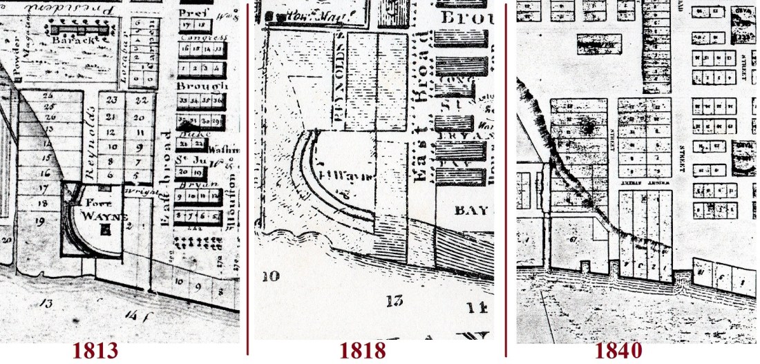
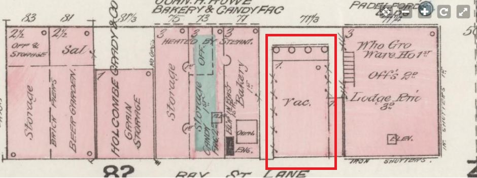
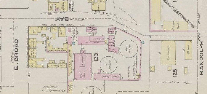
They are mysterious and old; the unexplained empty caverns beneath the plateau of Bay Street next to the 1905 City Hall where the ancient 1799 City Exchange once stood. They were referred to as stores, as vaults, as caves and as tombs; they were an embarrassment to the city and a curiosity to the public. They seem to have been viewed as a failure by both the architect that designed them and the man who took over their lease. They were erected to form the earliest retaining walls of today’s Factors’ Walk and seem to have been intended as general purpose (barrels, dray-cart, machinery, equipment or export) storehouses… but even as a later correspondent noted with derision, their purpose was never well-defined.
In February of 1839 City Council received a concerning report.
Savannah Republican, February 15, 1839
The old timber retaining wall east of the Exchange was rotting out. Over the next several months the idea of replacing the old wooden timbers with a more wall of greater permanence began to gain traction, encouraged by the local merchants.
In 1839 River Street was a newly-created, barely extant dead-end alley that was still only passable on its western half; the dray-cart alleyways of Factors’ Walk remained the most effective method of navigating the various wharf properties. This juncture in time found the Savannah Riverfront poised on the precipice between the quaint era of its early 19th century “stores” and “factors” vs. the more industrialized era of the mid-to-late 19th century River Street “ranges” and commercial superstructures, still fifteen years away. Where today we see vast stone walls and ramps in 1839 there was only sand and occasional timber retaining supports. In many ways, it was this endeavor that marked the beginning of the maturing era… but it came with its own set of growing pains.
On December 5, 1839, City Council authorized a committee to entertain “proposals to build a permanent wall of brick or stone at the public walk east of the Exchange and west of Drayton street.” In the early months of 1840 notice was printed in the newspapers that the city was accepting bids for the construction of a permanent wall. And not just a wall… hidden in the small print lay the creation of a ramp as well. “The design is to carry up a brick or stone wall from the north east corner of the Exchange to a point on Bay street, having a street-way to the northward down the bluff.” In other words, considering that in 1840 River Street was effectively impassable east of Drayton, this ramp was designed to create a thoroughfare access to Bay Street and the east.
Daily Republican, 1840
Charles Cluskey (c.1808-1871) submitted a bid. In 1840 Cluskey was an up and coming architect in Savannah; by 1839 he had already designed the Sorrell-Weed House, and he would soon thereafter design the Champion-McAlpin-Harper Fowlkes House and the Sisters of Mercy Convent.
The easternmost vault displays a plaque explaining what little we know of Cluskey
On March 19, 1840 the bid offered by Cluskey, “was accepted, being for the smallest sum.” Several weeks later Cluskey sweetened the deal and evidently impressed the Committee by proposing to construct a collection of general storage facilities, or “stores,” within the wall. On May 7, 1840 Cluskey was awarded the contract to “have four stores constructed in that portion.” A month later, on June 3, more details were forthcoming as Cluskey offered “to erect four stores 40ft deep & 20 ft front each for $3000… under the proposed extended walk with proper walls & arched roofs.”
Daily Republican, June 8, 1840
Vault interior, HABS Survey image, late 1960s (Library of Congress)
Something that should be understood even today: These stores were not excavations; they were instead free-standing structures, built from the ground up, later to be in-filled to create the promenade above. Cluskey was advanced $1000 by the city in July and another $300 in October, but the work and all of its initial promise stalled. On October 9 a letter to the editor of the Daily Republican was published by a confused bystander:
“Editors: —In one of my morning rambles toward the Exchange, I made the enquiry, why has the building of the stores about being erected to the East of and adjoining the Exchange, and upon which our merchants were promised a flat roof and promenade been suspended? An individual near at the time replied—‘there is another story to be raised above that.’ I said I did not understand…. [He said] that overtures had been made to some of our merchants, endeavoring to impress upon them, what a convenient thing it would be, to run a range of stores facing upon the foundation now laid; where Cotton samples might be deposited, and counting rooms established…. I cannot positively say it is so. But enough has leaked out to alarm me.”
Nothing more is said in the record of any plans for a second story; this may have just been a rumor arising from the work stoppage. But as 1840 dragged deep into 1841 the City became increasingly impatient with the unfinished structures; Cluskey, in the mean time, was distracted with other contracts like rebuilding the city’s cisterns and the construction of the new jail building south of Liberty Street.
The editors of Savannah Daily Republican chimed in by the late spring of 1841, remarking of the abandoned project east of the Exchange:
Savannah Daily Republican, May 2, 1841
In the Proceedings of Council on July 15, 1841 it was “Resolved, That if Mr. C. B. Clusky does not complete the work at the east end of the Exchange, so far as the filling over the arches of his stores and the completion of the work by the 30th July, that Council will order the work done at the cost of Mr. Clusky.”
Of varying sizes… due to the slope of the ramp the vaults taper in size from west to east; easternmost (left) is the smallest, westernmost (right) largest
The City Council and the newspapers weren’t the only parties to find the situation unacceptable; even average citizens were becoming annoyed over the stalled project. Days after City Council decided to act a correspondence to the Editors of the Republican was published, railing against the immense complexities of building “a simple Wall,” and making the first derogatory reference to the vaults as… “the tombs.”
Daily Republican, July 20, 1841
New York’s “Tombs,” 1870s engraving (Wikipedia)
The references above would not have been lost on a contemporary audience. In 1838 the City of New York had attracted national headlines with the erection of a highly-stylized prison; an over-budget and over-schedule architectural folly whose outward resemblance to an ancient Egyptian necropolis had elicited a nickname within the vernacular as “the Tombs.” The term had become something of a running joke across the nation to describe any architectural project subject to exorbitant cost overruns and work delays—in short, any wasteful architectural project exceeding its grasp. Now Savannah had its own example of the “tombs,” sometimes referred to in terms of the New York folly… but just as often referred to in the more literal context of the nearest graveyard.
Days following the above complaint, the July 31 Savannah Daily Republican received another letter they confessed that—due to language—they could not publish in full, but instead chose to carefully paraphrase: “The communication recommends that the caves at the east of the Exchange, should be made literally into tombs, in which to bury the present dynasty of Aldermen. As the writer reflects rather severely upon the Board, we must decline its publication. The manuscript will be returned or committed to the ‘barrel,’ as the author may desire.”
Vault #3
Cluskey appears to have not replied to the Aldermen’s demand (and evidently paid little heed to his newspapers), for by the September 23 Proceedings of Council it was “Resolved, That the Committee on Public Buildings be instructed to have an interview with Mr. Clusky, the contractor for the wall and buildings at the eastern end of the Exchange, and ascertain from him whether he intends completing said buildings and walls forthwith: and that said committee be instructed, in case that he does not give satisfactory evidence of completing said improvements as speedily as possible, then that said committee be authorized to contract with some other workman to finish it at the proper costs of Mr. Clusky.”
By October 7, the Committee had “had an interview with Mr. Clusky about completing the work on the brick buildings adjoining east of the Exchange, who promises to have the work all done and completed by the last of the present month (October).”
Yeah, that didn’t happen. Soon after the New Year rang in on 1842, the January 11 Savannah Daily Republican—waxing poetic with tongue firmly in cheek—published an editorial on the issue of certain city construction projects that seemed “forever in progress….”
“We are compelled to refer again to the catacombs near the Exchange, commonly called ‘THE TOMBS.’ These structures are chiefly remarkable for their antiquity, and the date of their commencement is almost lost in the mystery of past time. The Arab, when he makes his evening fire against the fallen columns of Palmyra and Balbeck, fancies that it was a race of giants who erected such imposing wonders…. Are we pygmies that we cannot take up our hammers and chisels, and complete what a race of people have begun who will be pronounced our superiors unless we show our prowess at once? Let them be finished, and these ‘doleful sounds’ shall be heard no more.”
By January 27, 1842 the Committee on Public Buildings noted with exasperation that there was nothing in the contract with Cluskey to compel an end date to the endless project. “They had several interviews with Mr. Clusky on the subject of the work he contracted to do for the City East of the Exchange. The Committee have also examined the memorandum of agreement between the Mayor and Aldermen of the City of Savannah and C.B. Clusky to do said work, and they find nothing in that instrument to compel Mr. Clusky to complete the work within any definite time. The Committee have endeavored to remedy the defect in the original agreement, but have not succeeded as well as they could wish. A note addressed to the Committee is all they could get from him. In that note Mr. Clusky promised to have the work complete within ninety days from date.”
This also did not happen. It seems that Cluskey was otherwise overdrawn; a month later, in March of 1842, he was essentially sued by John Dillon, and a lien was placed Cluskey’s twenty-year lease on the stores.
Daily Republican, March, 1842
In the wake of the forced sale of his lease, Cluskey officially abandoned the project he had essentially abandoned two years earlier. By August 25, 1842 the Committee remarked that the work “east of the Exchange has not been performed,” and was now considering “said contract or understanding null and void.”
On August 31 another infuriated Letter to the Editor appeared in the Republican:
“Improvement East of the Exchange, or more familiarly known as the tombs. Ah! here is indeed something to boast of, a monument like the Egyptian Pyramids, the wonder of the present age and a puzzle to the future. These tombs, however, cost $2,367 without any useful purpose to the city; the builder has the use of them for 20 years, and was paid this large sum to induce him to construct for his own private benefit these buildings on the public property!”
Two weeks later, by September 8, the City Council officially recognized a new contractor on the project: William Walker. “The Committee on Public Buildings, to whom was referred the matter of contract or understanding with Mr. C. B. Clusky, for furnishing materials, and building and completing the brick vaults East of the Exchange, and for furnishing and putting up an iron railing on the wall of said vaults, with powers to act: – Report, That the said Mr. C. B. Clusky has made a surrender of said job to Mr. Wm. S. Walker, who has given bond and security to complete said work by the first of September next.” Almost two and-a-half years after Cluskey had been awarded the original contract, Walker was now the chief builder and John Dillon now the holder of the lease.
Walker’s contract to complete the erection of the structures by September of 1843 seems to have been met; there does not appear to be any completion notice in the record, but neither was there further haranguing within the newspapers. The following year, in the July 25, 1844 Proceedings of Council, the “petition of John Dillon, asking Council to pave over the ground East of the Exchange, above the stores erected by C. B. Clusky was referred to the Streets and Lane Committee.” So by the late summer of 1844, the finishing touches were at last being placed upon the project as lessee Dillon was seeking to create and pave the surface level above the vaults.
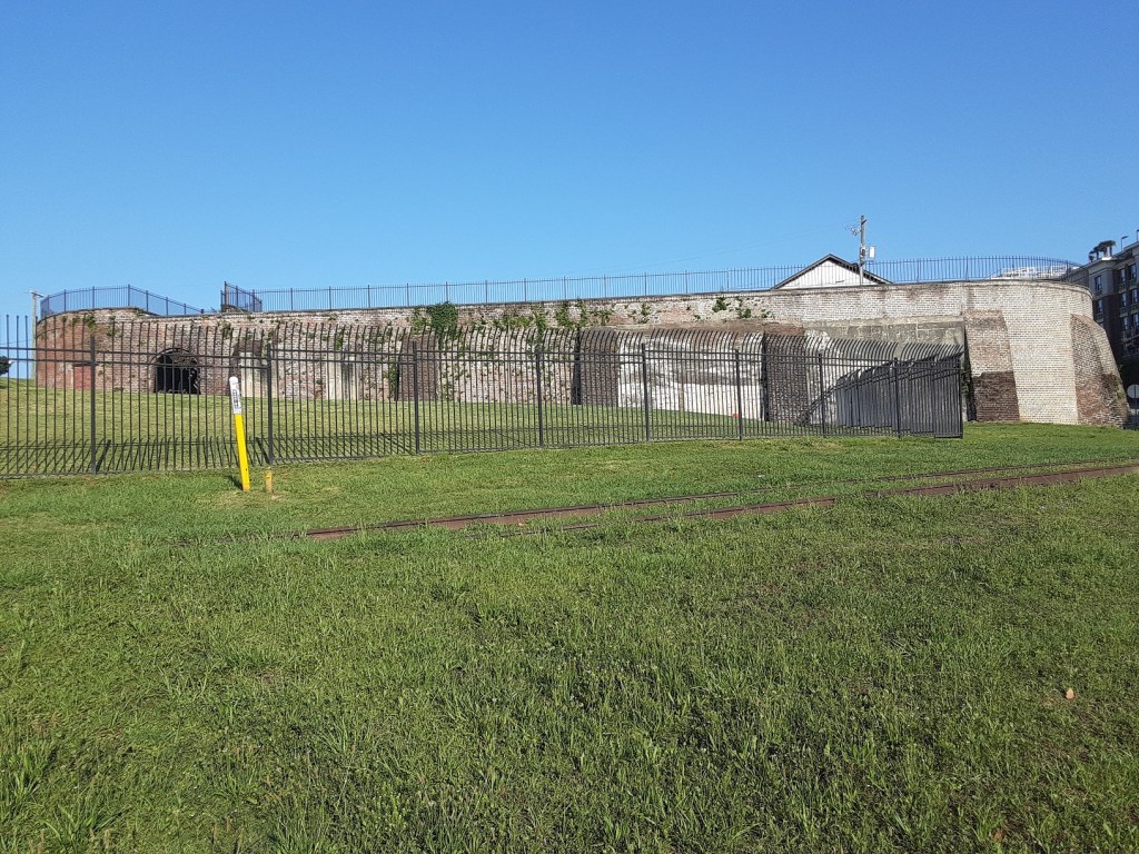
Cluskey Vaults as seen from the Gamble Building balcony, 2024
The end result (following the four-year saga) was not at all what the City Council had originally envisioned, and the general consensus was that the finished product—vacated by its own architect—was an unattractive series of holes in a wall. Four years earlier these curious structures had been maligned as “the tombs;” the nickname stuck. By 1845, “Tomb No. 4” had a working tenant.
Savannah Daily Republican, November 19, 1845
In the decades following their completion the “tombs” became an odd but unmistakable landmark of the town, fulfilling the 1842 prophesy that they would become “a puzzle to the future.” Under the heading of “Coast Survey”, the January 7, 1851 Savannah Daily Republican remarked that “Mr. Boutelle… has contracted with Mr. G. Butler to erect a small temporary observatory over the Tombs east of the Exchange, for the purpose of making observations for latitude and longitude.”
In 1855 and 1856 the vaults played a minor (but documented) role in the construction of the Abercorn and Barnard Street ramps, as the city paid John Dillon both years for the storage of barrels of lime used in the projects; the Mayor’s Annual Report of 1855 records payment of $30, and in 1856 $72. By the following year John Dillon had either surrendered or sold his lease; the 1857 Mayor’s Annual Report finds the tombs had prematurely defaulted back to the City. In 1857 the City recorded its first tenant of the tombs—no less than the US federal government, paying $225 for rent of the vaults. The US government continued its lease of the vaults until 1861.
The February 5, 1859 Savannah Morning News found “John Stoddard, owner of the wharf lots 7 and 8 (Stoddard Range), East of the Exchange, desirous of improving the stores by adding another story, asking the privilege ‘to throw a light and strong bridge from the terrace, now known as the Tombs, toward the platform of the store now occupied by Wm. Battersby & Co., said bridge to be 15 feet above the pavement below;’ also asking ‘a perpetual lease of two of the arches, at a nominal rent, in order to construct therein water closets, which will produce considerable revenue to the city.’”
So… had Stoddard just offered to turn two of the vaults into restrooms? There is no follow-up that I’ve found, so I think the answer to whether the Cluskey Stores ever became restrooms is probably no. While it is clear the city never knew what to do with the properties, they did not necessarily trust anyone else with them, either. It is important to point out that even when the vaults were under lease, they were still city-owned properties… which would have rendered the city criminally liable for any illegal activity conducted within.
In February of 1869 the City Council rejected an offer by Ketchum & Hartridge to buy the lot east of the Exchange, “including the tombs beneath.” While admitting the vaults and the promenade above were “an irregular, ill-looking affair,” this generation of the City Council was unsure it even had the right to sell this city property. Interestingly, the city’s nebulous claim to Factors’ Walk was challenged twenty years later, but it was not this block. In 1887, following a three-year legal standoff with the guano company of Wilcox & Gibbs, the city relented and sold the block of Factors’ Walk west of the Exchange. That action resulted in the prompt demolition of that block of Factors’ Walk, an act which proved controversial; the city did not repeat that error east of the Exchange.
Still around: detail of the vaults from the 1888 Sanborn Map, delineating them as “Storage Cellars”
The small, bricked-up vault to the east of the others
Over the subsequent decades the city made modest rents from the vaults east of the Exchange, as recorded in the Mayor’s Annual Reports. The “tenements in the tombs” fetched $273.58 in 1873, $291.63 in 1874, $175 in 1879, $250 in 1883, $150 in 1887, $275 in 1893; in 1888 they housed disinfectants while in 1899 Ferst, Sons & Co. were allowed to rent them “for the purpose of storing fireworks in original packages.”
Already mentioned is the tapering geography of the vault shrinking in size up the incline; the smallest vault today was not the end. Sometimes referred to as four in number and sometimes as five (recall the 1842 Sheriff’s Sale notice above), the vaults have indeed lost one of their number over time; the easternmost “mini vault” was subsequently bricked up, leaving today only the larger four. The footprint of this smallest vault, however, is still clearly visible in the wall today.
Were the Stores ever used to hold enslaved persons?
As a coda, it is worth taking a moment to address a bit of popular lore that grown spread around the vaults in recent years. Sometimes a story fits around a preconceived notion so beautifully the conclusion to be drawn is that it simply has to be true. I think of my friend Marcus, who years ago gleefully shared with anyone he met that “Daufuski” was derived from a Gullah pronunciation of “the first key,” meaning the first island of South Carolina’s coast. Of course years later I learned that Daufuski was a Creek name, so while Marcus’ explanation was really cool and made logical sense… it was simply wrong.
This analogy seems to me not unlike the specter of the Cluskey Stores. Pausing before them—much like standing at the door of an old ruin—one is overtaken by an ominous sense of wonder. People whisper tales of slaves possibly being held here, and it’s easy to believe… for a moment, anyway. But much like Marcus’ story, the facts stand in the way of a good story. So to answer the question above… did the Stores ever hold enslaved persons? My conclusion is no, for three reasons:
Wrong time period. The Cluskey Embankment Stores were erected more than four decades after Savannah’s Atlantic trade had ceased… essentially 45 years too late. Congress outlawed the United States’ involvement in the African slave trade effective 1808, but even by this date Georgia was no longer active. Savannah’s large-scale Atlantic slave trade lasted a total of 23 years, over two periods: from 1766-1774 (accounting for roughly 10,000 individuals) and again between 1784-1799 (roughly 7500); in 1798 Georgia’s State Constitution barred the Atlantic trade. More can be seen on Savannah’s role in the 18th century African Trade in a separate post, but to be clear, there is no part of Factors’ Walk that dates to this era; the riverfront that we see today arose entirely out of the next century—River Street, for example, didn’t have any beginning before the 1830s. With the Cluskey Stores erected in the 1840s, claiming that they held enslaved Africans is not unlike claiming a particular Model-T was the one that John Wilkes Booth made his getaway in… it conflates different time periods.
Never once in their recorded history does the word “slave” ever enter into connection with them. Because of the beleaguered construction history of the Cluskey Stores, in many ways this represents the best-documented single block of either Factors’ Walk or River Street. This was the first and oldest permanent Factors’ Walk retaining wall… and given this experience it would be another decade before the City Council would attempt to contract retaining walls for the bluff again. Archaeological surveys conducted within the structures have yielded no evidence to suggest occupation by enslaved persons, and never once in their recorded history is the word “slave” associated with them. Had such a public venue in so widely a used commercial thoroughfare held human beings this would have attracted attention somewhere in the record. No one was coy on the subject of slavery—there were numerous well-publicized sites in town where enslaved persons were kept and sold in this very time period, many of which are discussed at length in another post. I would suggest claiming this was a site where enslaved persons were held is a genuine disservice to still-existing sites that were.
Impractical, possibly even illegal.Even looking at the structures today, containing people within them seems somewhat impractical. Also, holding enslaved persons here might have been illegal. As mentioned above, regardless of who leased the properties over the years, the vaults remained city-owned properties… which would have rendered the city criminally liable for any activity conducted within. The commercial lockup at Bryan & Habersham, the Pulaski House Hotel basement and the Wright slave yard were documented places where interstate slaves were held, but these were commercial/private entities. As to any argument the vaults might have played a role in housing trafficked persons from the Wanderer in December 1858, I will point out that the vaults were actually leased by the US federal government between the years of 1857-1861… rendering them pretty much the worst conceivable place in Savannah to consider hiding illegal persons.
After researching these Cluskey Store vaults for years one conclusion is quite clear: these structures were viewed as a colossal blunder almost from the start; left unfinished and to serve no clear purpose. They remained something of a joke in subsequent decades, referred to as arches, vaults, holes, caves, tombs, “a melancholy monument of inefficiency,” or “an ill-looking affair”… possibly proposed in 1859 for restrooms; in subsequent decades storing disinfectants and fireworks. Ultimately, they remain enigmas to us as much as they did to the generation that witnessed their construction, fulfilling the prophesy of that 1842 correspondent that they were to become “a monument like the Egyptian Pyramids, the wonder of the present age and a puzzle to the future.”
The four surviving Cluskey Vaults in 2024Interiors of the two vaults to the eastInteriors of the two vaults to the west
One of the plaques greeting a visitor at the vaults today
One of the plaques greeting a visitor at the vaults today
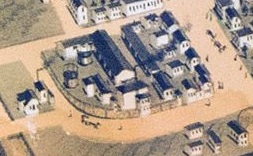
Riverfront depicted on the 1891 Birdseye View of Savannah
So what was a factor… or a factorage? How exactly were the buildings of today’s River Street used? How have they changed and what personalities once roamed their creaky floors? Come explore the true history of River Street and its buildings.
A long-gone structure on the north side of West River Street
Factors’ Walk at Drayton
In the short span between 1852 and 1859 five large industrial ranges were erected on the riverfront, joining, merging with or replacing seven iconic older ranges erected between 1806 and 1813.
In considering River Street it is important to recognize that the riverfront we see today was very much a creation of the 19th century; the 18th century riverfront has been utterly washed away by the tides of time. I’ve made this observation elsewhere, but it bears repeating; there is no current structure or element of construction north of the south side of Bay Street that predates 1800. No building, no wall, no foundations, no two stones glued together north of Bay Street date before the 19th century. Our conception makes it old—it feels old—but the Belgian block pavement was laid down in the 20th century; the train tracks are likewise 20th century and were used until 1999. And while the cobblestones on the ramps do date back to the 19th century, the pavement that runs the entire length of Factors’ Walk—though a nice homage—is modern stamped concrete.
20th and 21st century elements integrated into Savannah’s historic waterfront
But what about the buildings? The bulk of these buildings lining today’s River Street—superstructures more often referred to as ranges—were constructed between 1806 and 1877.
Active Riverfront, as depicted in an 1884 engraving
The 1850s left an indelible stamp on River Street, so much so that even the early 19th century riverfront is sometimes difficult to find beneath the superstructures. Rediscovering the early 19th century buildings relies on clues one finds in advertisements that are found by keywords, like “fire proof stores”—such was how all of the early brick and stone structures on the waterfront were described in newspaper advertisements of the day. While there may be nothing before 1800 represented in the brick and mortar of today’s River Street, there is an entire treasure trove of construction between 1800 and 1820 hiding in plain sight amidst the later structures, the remnant and record of what I call the “Stores Era.”
What is perhaps not understood today about these buildings of the riverfront and their use can be boiled down to two points….
When we speak today of the River Street warehouses we are often looking at the wrong side of the street. Outside of a few buildings on the western end of River Street, the buildings that stand today on River Street were not generally used for the storage of imports/exports. The genuine warehouses and storage sheds were on the wharves, on the north end of today’s River Street, in more utilitarian structures that are long gone today.
Take, for example, the 1884 Sanborn Map, depicting Commerce Row, which shows more square footage of development on the River side than the Bay Street side, and partly explains why the successor to Commerce Row—the 1890 Commercial Row and its eventual successor, 1981’s Hyatt—possessed the air rights to cross over River Street.
1884 Sanborn Fire Insurance Map, Commerce Row, west of City Exchange (River Street is compressed into the narrow space where the number 76 is printed)
While we’re examining maps let’s consider another from a few years later. Below is the complete Riverfront edited together from the 1898 Sanborn Maps, demonstrating nary an empty foot of space north of the street. The properties north of River Street were fully occupied with storage sheds, ladings and lumber and coal yards. From east to west (or left to right) the map below depicts a Guano storage warehouse, followed by the E.B. Hunting Lumber Yard, C.H. Dixon Coal Yard & Shed, Gibson’s Wharf structures, Georgia Lumber Company Lumber Yard, a collection of various unidentified wharves and sheds gathered as a compound, T.F. Johnson Coal Yard, unidentified freight shed, Dixon & Company Lumber Yard and Savannah Cotton Press Association Lumber Yard and storage sheds.
1898 Riverfront (yellow indicates wooden structures, pink brick, with white representing holding yards)
Turn of the 20th century on River Street, and there’s no place to park
This postcard image, a rough contemporary of the map above, drives the point home further, as we gaze down into the massive Georgia Lumber Company Yard compound, following it eventually to the Gibson Lading sheds before the horizon clusters into indistinguishable rooftops.
So if the buildings and structures crowding the north side of the street were the warehouses and sheds… what were the buildings that we see today on the south side of River Street used for? That leads us to the second point…
The buildings we see today were intended as commercial rental units. The buildings on the south side of today’s River Street were the administrative offices (the “counting rooms”) and commercial space. They were basically the strip malls of the early 19th century. Many of the merchants who had the buildings constructed never intended to occupy more than one or two rooms of the properties. These ranges were the commercial and business parks of their day, home to any variety of leasable commercial, mercantile or office space. Think of the shopping mart of today; a shopping plaza is typically built around some large anchor store—usually a grocery store—and the rest of the plaza is left as leasable retail space for ancillary and complimentary stores, all of these smaller properties help to offset the costs of the whole.
Meet the Factors
Consider, for example, the previously-mentioned ancient buildings of Commerce Row. In 1806 Joseph Habersham advertised his former office for lease:
The following year, in 1807, Robert and John Bolton posted a “for rent” notice within their Commerce Row property as well.
Georgia Republican, January 27, 1807
The advertisement above alluded to four small-business owners leasing within the property: John Jackson, William Woodbridge, Joseph Rice and Dr. Ewell… so what exactly did these four men do within the walls of the building… and were they factors? Yes, they were.
John Jackson began his store in 1804; it was something of a hardware store (with “ironmongery,” “crockery,” “window glass” and “paints”), crossed with a fabric store (with “superfine cloths,” “blankets and blanketing,” “hosiery” and “hats”), before he passed away abruptly in late 1807.
William Woodbridge sold hardware as well, but his store also specialized in liquor and groceries.
Joseph Rice, in the mean time, was a watchmaker and offered jewelry, swords, canes, pocket-books and elegant china.
Dr. James Ewell moved to Savannah from Virginia in 1801; he operated a pharmacy and had moved his wholesale “medical warehouse” into the Bolton building in 1803. An advertisement for James Ewell and his new warehouse:
Georgia Republican, April 21, 1803
Clearly, the clientele leasing these properties was as diverse as the merchandise, goods and services they tendered. The four factors above were not alone in Commerce Row; another tenant was Alexander Watt. If his name sounds familiar it’s because Watt was active in the Atlantic slave trade in Savannah during the late 1790s. As established in an earlier post, many of the Savannah merchants involved in the Atlantic slave trade were general importers, and not dedicated slavers. By 1799 the Atlantic trade had ceased in Georgia, and most of these vendors simply returned to promoting alcohol, produce, fine fabric, sugar and shoes.
This was what Watt’s advertisements looked like in 1800, post-slave trade:
Georgia Gazette, October 9, 1800
From selling “prime young Negroes” in 1799 to selling “prime Negro Shoes” in 1800, Watt showed no less enthusiasm in promoting his inventory. He died the following year, in November of 1801.
The commercial or business spaces within these stores—“tenements” was the common term for rental units—were short-term or long-term leases, and after a lease was up the lessee would choose either to re-up, expand, partner-up or move to a different retail location. The below advertisement from 1810 illustrated what could happen to deadbeat tenants, as William Sawyer and John Mingledorf found themselves in arrears.
Republican & Savannah Evening Ledger, April 17, 1810
In the late 18th/early 19th centuries Savannah newspapers were filled with advertisements headed “Factorage.” It’s a word and an industry that is lost today to the recesses of time. It made its earliest appearance in Savannah print in the summer of 1766, as William Moore took possession of “the wharf and stores formerly the property of Capt. Nicholas Horton.”
William Moore’s “Factorage business,” July 16, 1766 Georgia Gazette
Factors were wholesale retailers, taking advantage of anything and everything being offloaded from a vessel at port. Fruits, produce, alcohol, tobacco, fine linens and any type of exotica or item of interest would be taken in by a factor and offered to the public. This was the new economy, and in the late 18th century, a factorage was an easy business prospect that required little capital; one needed only to lease available space on these riverfront stores for a showroom and post an occasional ad in the paper offering practical items or exotica.
An advertisement claiming “a general assortment of goods” from a particular vessel usually meant the factor had entered into an agreement to take all of the remaining inventory from the vessel, effectively transferring its cargo hold to his shelves. This was exactly how David Sandidge began his factorage in 1796, emptying out what remained on the ship Tammany, moving it into a Commerce Row tenement he had just rented and calling it a shop.
Columbia Museum & Savannah Advertiser, November 22, 1796
Six months later he was advertising saddles, whips and canes swords; leaving the impression his shop’s inventory may have varied by the ship. Sandidge, however, proved successful in his factorage and later doubled his retail space to include tenement 5 as well. His advertisements fade away after 1800, and he died about 1803.
In the 1809 tax digest there are several individuals identified as “Factors.” Tellingly, many of these factors were shown to own little or no property of their own; few owned wharves or land or even their own homes. In my early years of studying Savannah history I had simply imagined these “factors of yore” to be some rarefied class of gentlemen like a long-forgotten secret society or guild; the reality was far less glamorous. For every factor or merchant with means who met with enough success to sustain and flourish—Robert Bolton, the Joneses, the Telfairs, Richard Richardson (listed below, pre-Owens-Thomas House) or any of the import “merchant princes” that dominated Savannah society by the 1810s—there were far more often flame-outs who came and went with the rent cycle.
Young white men owning little property but identified as “factors” in the 1809 tax digest
Some men abandoned carefully crafted careers—seemingly on a whim—to become factors. Take for example one John C. Lege; an established dance instructor who built his own dance and assembly hall at the corner of Bull and Broughton in 1822. In 1825 his hall even hosted a formal Masonic dinner for Lafayette in 1825. But the depression of the 1820s impacted his business; by 1828 Lege had shifted his career from dance instruction to a factor… only to return to his former profession some five years later, by 1833. It was a new economy, but only a few navigated it successfully.
The full circle of John Lege:
There and back again: From financially troubled dance instructor (November, 1824) to struggling factor (March, 1829) back to dance instructor (October, 1833)
The August 27, 1799 Columbia Museum & Savannah Advertiser exemplifies this daring new economy of factors and factorages. Here are six ads in sequence, all six either from factors advertising goods or introducing a new factorage businesses:
Columbia Museum & Savannah Advertiser, August 27, 1799
“Glazed chimney Tiles, Window Glass, 8 by 10, Madeira Wine,” “English cheese, pickles,” “shingles, 600 gallons fresh Orange Juice;” these were the diverse treasures offered by these factors of 1790s Savannah.
There are no elements of these factorage buildings surviving from the 1790s; the oldest surviving riverfront structure today is probably the William Taylor Stores, whose earliest elements date to 1806. In terms of physicality, the early riverfront “stores” of the 1806-1819 period shared a similar architectural profile; so many went up in a very brief span of time: the Taylor Stores, the Howard Stores, Commerce Row, the Archibald Smith Stores, one or more buildings of the Johnston Range, the Fraser Stores and elements of the Jones Stores and Hunter Stores all seem to have gone up between 1806 and 1819, and many overlapping with one another. These structures were typically two, three or four stories, with pitched roofs, often a mélange of stone and brick in construction. Two of these older properties stand intact today; the William Taylor Stores and the Archibald Smith Stores. On the western end of River Street the Johnston Range isn’t a single structure but three different buildings merged together on its wharf, while on the eastern end of River Street Anderson’s eastern mart—though today much altered—remains the only example of a two-story range not rising above the bluff. In many respects Commerce Row was the gold standard of this early 19th century architectural template; while it is gone, images remain. Originally three levels, portions of the 1809 Howard Stores and the Fraser Stores form the lower levels of today’s 1859 Stoddard’s Lower Range; similarly, portions of the earlier iterations of the Jones and Hunter Stores still exist within the later 1857/58 Jones Superstructure.
By the 1850s “factorage” was a largely archaic term, and the character of the riverfront had changed significantly. The wharf was no longer a speculative market of exotic world goods, but more practical staples for a town more poised towards large-scale industry; pitch, petroleum, guano and other fertilizer, grain, coal, lumber, ballast and industrial goods. To offer a more contemporary analogy, the stores on the Bay had transformed from World Market… to Home Depot.
Consider Commerce Row, which as we saw above hosted at the turn of the 19th century stores offering hardware, liquor, rare fineries and a pharmacy; 70 years later much of the entire block was given over to the importation and sale of guano, fertilizer from the excrement of bats and seabirds. From diverse exotic goods to manure in less than 70 years.
Of course, one cannot overlook the role of cotton played in the story of the riverfront. As a correspondent to the Newark Daily Advertiser noted in a January 18, 1851 letter: “The amount of business transacted here is very great, cotton is the great article of merchandise, and as you wander along the wharves, and examine the store-houses, you will see acre after acre covered with the great staple.” (quoted within Savannah Morning News, February 4, 1851)
Similarly, the buildings and expansions of the 1850s exhibited a different character… larger, more imposing, flat roofs, more urban and industrial. These were not the simple quaint “stores” of 1806-1820. There are no fewer than five range buildings on today’s River Street dating from the brief span between 1852 and 1859… an era which also coincided with the erection of the bluff’s retaining walls. In short, River Street began to adopt the profile we would recognize in the 1850s.
Really, today’s River Street is largely a product of three epochs, with five intact buildings or ranges from the “stores” era of 1806-1820 (the Taylor Stores, the Smith Stores, Anderson’s Wharf 5 mart, and the Johnston & Williamson ranges), the five large ranges built between 1852 and 1859 (Claghorn & Cunningham, the two Jones ranges and the two Stoddard ranges) and an additional six buildings erected between 1874 and 1910 (United Hydraulic Cotton Press, Kelly’s Stores, Savannah Cotton Exchange, Tidewater Oil Range, City Hall & the Lowden Building ).
A Survey of the Buildings of River Street
With a diverse mix of time periods, styles and building materials, River Street is a showcase of the 19th century. Today’s old commercial and industrial buildings span more than a century between 1806 and 1910; the buildings hold stories, the stones bear legacy and tales have seeped into the mortar and lime. Factor-merchants… while many of them had the vague description of “merchandise” attributed to them in the tax digests and were not actual landowners, those that did own a wharf often owned more than one. Some wharves were built on previous iterations and grew in prosperity, while others peaked in their early years and never recovered. One wharf building was constructed for a man who quickly failed as wharf owner only to encounter success creating a steam-boat company. One wharf building was constructed for a six-year veteran foot-soldier in the American Revolution, while the neighboring wharf was built for a man whose sister had married into the family of Georgia’s Royal Governor, Sir James Wright. One wharf was owned by a man killed in a duel with a former Savannah mayor, another was owned by a former Savannah mayor. From established Savannah names (Jones and Telfair) to friendly outside carpetbaggers (Kelly), the buildings of River Street have stories to tell that would “amaze indeed the very faculties of eyes and ears.”
So let’s take an opportunity to better examine the legacy left today in the surviving—and some not surviving—structures of River Street, beginning at the east and moving to the west….
Demolished eastern wharves (Wharves 8, 9 & 10 East of Lincoln)_
In looking at the 1884 Sanborn Map, it is clear that most of this eastern end of River Street is a construction that came long after publication of the map; not a single building depicted in the Sanborn image below still exists. Even the Tidewater Oil building—the most easterly building found on River Street today—did not yet exist and was a product of the 1890s. The Steam Rice Mill property, anchoring the east end of River Street since 1852, came up for sale in 1898. Its purchase and removal finally offered the opportunity to open River Street into a thoroughfare, a goal of the city for more than 60 years. “River Street to be Opened,” declared the March 24, 1898 Morning News. “The property is something which the city has been endeavoring to secure for the last several years and various attempts have been made, but always without success.” With no 19th century barrier left, River Street at last entered the 20th century fully traversable from end to end; no street in Savannah had taken so long or proved so challenging to open.
Peruse the map illustration below knowing that almost nothing illustrated on it exists today.
Nothing illustrated here exists today. Crazy
Eastern riverfront as depicted in the 1871 Birdseye View
Twenty years later (1891 Birdseye): Industrial congestion. The largest structures—the Rice Mill and the Rourke Iron Works (white building to the left with the cupola)—are long gone today.
Rourke Iron Works, destroyed in a hurricane, August, 1940 (GHS coll.#1361PH); location today of the Homewood Suites
East River Street in 2024… Morrell Park is a block-long park formerly occupied by buildings
The River Street Marketplace on the eastern end of River Street… while a fine place to find gifts, oddities and souvenirs, these two structures occupying the north side of the street are entirely a product of the 21st century, erected in 2011
504 – 516 East Bay Street, “Tidewater Oil Building” (Wharf Lot 7 & eastern portion of 6 East of Lincoln)
Bay Street side
River Street side
1892 – Built for Tidewater Oil Company
Staircase access on the western wall (left); February 14, 1892 Savannah Morning News (right)
The Tidewater Oil Company was incorporated in 1890, representing a merger between Savannah’s Blodgett, Moore & Co., Charleston’s Eber Blodgett & Co. and the Tidewater Oil Company of New York. But mergers maketh and mergers taketh away; by 1893—barely one year after the building was completed—the Standard Oil Company had taken over Tidewater Oil, and by 1897 all use of the 1892 building was surrendered.
504-516 East Bay Street in 2024
402 – 410 East Bay Street, “Anderson Stores” (Wharf Lot 4 East of Lincoln)
Bay Street side
River Street side
1835/36 – Built for George Anderson & Co.
1871 (top); 1891 (bottom)
George Wayne Anderson (c.1767-1847) was an active factor of the 1790s; displaced by the November 1796 fire, he and his family had moved into the home of his partner and co-factor Richard Wayne, until that too was consumed by the December 9 blaze just two weeks later. By November of 1797 the co-partnership dissolved but Anderson continued to rent the property on Wayne’s Wharf. Richard Wayne owned Wharf Lot 10 and the neighboring Yamacraw Wharf Lot 1; as we will see, through economics, estates or circumstance many of Savannah’s prominent merchants ended up in possession of multiple wharf lots, any two usually distinguished from one another as “Lower”—being the eastern property or “Upper”—being to the west.
On November 1, 1799 Smith, Sons, Douglas Anderson & Thomas Flint announced they had “removed from the Wharf and Stores they lately occupied, to Wayne’s large and commodious Stores, where they continue the SHIPPING, FACTORAGE and COMMISSION BUSINESS.”. The Smith, Sons, Anderson factorage is an interesting story; the company had begun in 1798 on the Johnston, Robertson & Co. wharf, the old Wharf Lot 16 West of Bull (which we will visit later). They added Thomas Flint to the partnership later in the year; he procured a ship called the Minerva for their commercial pursuits, only for its registration to quickly come under scrutiny. Flint claimed ownership and registered it under his name as a US citizen, only to have authorities suspect the Smiths owned it in part or in full. Given that the Smiths were identified in the charge as “aliens, and subjects of his Britannic Majesty, residing and carrying on a trade as merchants in the city of Savannah,” US District Court sought in injunction; the partnership did not survive and by 1801 had announced dissolution.
So in 1799, as Smith, Sons, Anderson & Flint were moving to the west onto Wayne’s Wharf, George Anderson moved to the east, effectively switching wharves with the former and moving either into or adjacent to the Johnston, Robertson & Co. mart on Lots 1 & 16 West of Bull. In December 3, 1799 Anderson posted an announcement in the newspapers that “The Subscriber has removed to the Wharf and Store, lately occupied by Messrs. Smith, Sons, Anderson and Flint, where he intends transacting business on COMMISSION, as herefore, and offers his services in that line, to his friends and others.”
A warning upfront… factors of this early era changed location almost as often as they changed partners.
By 1803 Anderson had graduated into ownership of his own wharf lot, neighboring Johnston, Robertson & Co., and advertisements of “Anderson’s Wharf” first appeared in the newspapers. This, however, was not the site today where the Anderson Range stands today; Anderson was another in that line of Savannah merchants ending up in possession of multiple wharf lots (because one wharf is never enough). This eastern, or “Lower,” wharf building of Lot 4 East of Lincoln was something of an afterthought; it was his upper Wharf Lot 2 West of Bull, site of today’s Lowden Building, that was his longer-held wharf and primary location. In the 1810 tax digest his Wharf Lot 2 was valued at a modest $13,000; his eastern wharf properties did not exist yet.
The story of his Lower Wharf property at today’s 402-410 East Bay Street began as Anderson expanded—at first even further to the east than Wharf Lot 4—coming into possession of Wharf Lot 5 East of Lincoln and the adjoining western half of 6 in 1817 or 1818.
1819 tax digest: “Whf Lot 5 & 1/2 6 & Bds, Washington [ward] $14,000″
This eastern lot & a half with buildings was valued at $14,000 in the 1819 tax digest, an inflated value typically consistent with a new construction on the site. The value dropped to $12,000 in the 1821 and fell precipitously thereafter. It was probably these c.1818 Anderson properties that were depicted years later on Wharf 5 as a two-story range on the 1871 and 1891 birdseye views.
Anderson properties of Wharf Lot 5 (“Wharf 5 mart,” or “Anderson’s eastern mart”)
Standing on the site today is a long, two-story range, composed of two adjoined buildings. The Morrison book does not address the property, nor does the 2011 MPC Survey mark the range as historic, but the two-story range standing today at 411-429 East River Street seems consistent with the one illustrated in the 1871 Birdseye and the 1891 Birdseye, and appears little changed across its depictions in the 1884 Sanborn, and the 1888, 1898, 1916 and 1950 editions. Though today heavily rehabbed, this low-profile, two-story, two-building range likely dates to 1818, was likely built for George Anderson—and as the only range today to not rise above the bluff—hearkens back to those earliest days of the 19th century riverfront before wharf properties were accessible above the bluff.
Wharf Lot 5 East of Lincoln today
Wharf Lot 4… Anderson’s last riverfront property
The value of his eastern wharf mart depreciated to $6000 by the 1826 tax digest, here it remained stagnant for the next six years, through the 1832 volume. Anderson expanded westward to Lot 4 by 1827, meaning that today’s 402-410 East Bay Street—which sits atop 4—was the last of his riverfront properties built.
1830 tax digest: Anderson owned “Whf Lot 4 & moiety No. 5 Washington”
In the tax digests of 1834 and 1835 the total of his eastern wharf holdings bumped up slightly to $7000, but by the 1836 digest the value had risen to $9000, and by 1837 $10,200. This was probably the period that saw the construction of today’s building on Wharf 4; this three-story brick building appears to have been built between 1835 and 1836. It should be pointed out, however, that his “2 Whfs & Marts & Impts Washington Ward” (1839 tax digest) of 4 and 5 still very much trailed the $18,000 valuation of his single Wharf 2 West of Bull.
In April, 1837, merchants Clark & Pelot were advertising from “Anderson’s new Stores” on Wharf 4.
Savannah Republican, April 7, 1837
Tenants William P. Clark and William Pelot began a partnership in November of 1836. “The Subscriber having this day taken Mr. Wm. M. Pelot into partnership, the business will in the future be conducted under the firm of Clark & Pelot,” Clark wrote in a November 22 advertisement printed in the Savannah Republican. “The Subscribers beg leave to inform their friends and the public, that they intend doing a Wholesale Grocery and Commission Business,” the partnership announced, running their business out of “Taylor’s Buildings,” on the west end of the riverfront.
Their business was not confined to groceries; at least one advertisement while they were housed in the Taylor Stores suggests their business was wide-ranging indeed…
Savannah Republican, January 16, 1837
On February 11, 1737 Clark & Pelot announced their removal from the Taylor Stores. “The undersigned have removed to Anderson’s new brick buildings on the Bay… where will be kept a constant and full supply of fresh and superior Groceries.” But Clark & Pelot was dissolved in December, 1837; today a one-night stand might last longer than some factorage partnerships of the 19th century.
The Wharf 4 Anderson Range depicted on the 1898 Sanborn, then Philip Daffin’s property
By 1840 the valuation of this Lower Wharf of 4, 5 and half of 6 had grown to $12,000, but it still trailed the $18,000 of Anderson’s Upper Wharf. According to the 1843 tax digest Anderson owned three different residential properties, one in Percival Ward, one in Decker Ward, but his residence was on Congress Street, overlooking Johnson Square, and there Anderson died in May of 1847; he is buried at Laurel Grove. In his last year of life his Lower Wharf holdings were valued at $15,000, still less than the $22,000 of his Upper Wharf.
In 1851 a man fell to his death from the third story of the Anderson Range.
Savannah Morning News, March 3, 1851
As a construction of the mid-1830s, the Anderson Stores represented a bridge—chronologically and architecturally—between the “stores” epoch of the 1800-1820 riverfront and the later, larger industrial ranges of the 1850s.
302 – 316 East Bay Street, “Scott & Balfour Stores,” and “Andrew Low Range” (Wharf Lot 1 & 2 East of Lincoln)
Bay Street side
River Street side (left); 1871 (top right); 1891 (bottom right)
1823 – Eastern half (Wharf Lot 2) Built for Robert Scott and John Balfour
1823 – Western half (Wharf Lot 1) Built for Andrew Low & Company
By 1858 – Additional level added
An old coal chute hides behind the bushes on the north side of the Wharf 2 building
“NOTICE, THE Copartnership of SCOTT, FISHER and SCOTT is this day disolved by mutual consent,” Robert Scott announced on November 5, 1805, adding that both of the Scotts could now to be found “at Messrs. MEIN, MACKAY & Co’s. counting house.” By May of 1809 William Mein and Robert Mackay went their separate ways, announcing the dissolution of Mein & Mackay; Mein partnered with his son Alexander for a decade, and in February of 1819, following the elder’s retirement, Alexander Mein partnered with Robert Scott, announcing that their “counting house is on Hunter’s range.” Margaret Hunter’s Range was a brand new structure at Reynolds Wharf Lot 5, which we will visit shortly. By June 1, 1822 even this partnership bit the dust as Alex Mein and Robert Scott announced that “The Co-partnership of the subscribers expires this day by its own limitation, and the same is hereby dissolved.” Scott wasted little time; six months later he announced another merchant partnership, this one with a one Mr. John Balfour.
The beginning of Scott & Balfour, January 9, 1823 Savannah Georgian
Scott & Balfour operated a counting house out of the Jones Range at Wharf Lot 4 in 1823, but it was a temporary lease while their own wharf was being built. Following more than two decades as a factor—but never owning any property—Robert Scott had finally ascended to the next level as a wharf owner. The 1823 tax digest recorded Warren Ward Wharf (or East of Lincoln Wharf) Lot 2 and buildings assessed at $15,000.
Meanwhile, Andrew Low & Company was a dry goods, mercantile and import company that existed in Savannah for more than 70 years. Curiously, the earliest reference to “Andrew Low & Co.” existing today is not one of his own advertisements, but rather an indirect reference found within a different factor’s advertisement in April of 1799.
Earliest reference to Andrew Low & Co., March 5, 1799 Columbia Museum & Savannah Advertiser
John Grieve and James Anderson announced their mercantile partnership, mentioning the site of their store “adjoining messrs. Andrew Low.” Oddly, the company belonging to Andrew Low seems to have existed at least three years before it advertised to the public in Savannah newspapers. Below marked the first advertisement of Andrew Low & Co., in May of 1802:
Georgia Gazette, May 6, 1802
Low’s new “Fire proof Stores,” Savannah Daily Republican, December 15, 1823
In 1810 Low established his company’s showroom at the southwest corner of Bull and Duke (now Congress), overlooking Johnson Square. The building burned in the Fire of 1820, but he rebuilt at this location, a brick structure he and his nephew would retain as their retail site for decades. On December 15, 1823 he began advertising his new “convenient wharf with Fire-proof Stores” on the River. The tax digest of 1824 listed Andrew Low’s properties on Johnson Square and his new Wharf Lot 1, each valued at $12,000. Andrew Low now owned the property on Lot 1 East of Lincoln while Scott & Balfour owned the adjoining Lot 2.
Wharf Lot 2 building (top) and Wharf Lot 1 building (bottom); both originally two levels, third level added 1850s
An accident on the Scott & Balfour Wharf, February 21, 1845 Savannah Daily Republican
In 1828 Low’s partner Robert Isaacs died; Low and James Taylor formed a partnership which lasted until 1834. In 1829 Low’s nephew and namesake came to America to work with his uncle; in 1839 the senior Andrew retired, leaving the 27 year-old to take charge of the business. The company already 40 years old as the younger Low took the reins, the Low empire continued to grow, becoming one of the most profitable and iconic commercial enterprises in 19th century Savannah.
A brick and stone melange peeks out from the stucco on the western wall
In the 1843 tax digest the Scott & Balfour Wharf was still valued at $15,000, the Andrew Low Wharf at $10,000. A rare success in factorage partnerships, the Scott & Balfour association endured for two decades, until John Balfour’s death in 1844. Robert Scott himself died the following year, in 1845. His widow and son advertised the wharf and stores for rent in 1846. Andrew Low seems to have exchanged wharves sometime thereafter; the tax digests of the 1850s switch from his previous association of Lot 1 to Lot 2.
In the following decade, as the massive ranges of John Stoddard and George Jones sprang up on the riverfront an additional level was added to the two buildings of this range; in 1851 Andrew Low’s Wharf Lot was assessed at $15,000, but by the 1853 tax digest it had risen to $30,000 and by 1858 $34,000, so it seems clear that the third level was in place by 1858.
The end of an era: Andrew Low & Co. dissolved , September 2, 1872 Savannah Morning News
The result of these 1850s improvements is that today the Wharf Lot 2 property stands about three feet taller than the western half at Lot 1. Both structures of the range today are stuccoed over; only occasional gaps or breaks in the stucco expose the brick and stone melange beneath the lower two levels.
The elder Andrew Low had overseen his company for 40 years, the younger Andrew Low continued the company for an additional 33 years before opting to retire at age 60. On August 31, 1872 Andrew Low & Co., an entity that the Morning News labeled as “identified with the history of Savannah for thee-quarters of a century,” came to an end.
208 – 230 East Bay Street, “Stoddard’s Lower Range” (Wharf Lots 1 & 2)
Bay Street side
River Street side
1871 (left); 1891 (right)
1809 – Eastern half (Wharf Lot 1) built for Samuel and Charles Howard, who promptly went broke (Lower three levels still extant)
1811 – Western half (Wharf Lot 2) built for Simon Fraser (Lower three levels still extant)
1858/59 – Superstructure consolidated both properties and added upper two levels
Conjectural configuration (in red) of the 1809-1811 buildings of Wharves 1 & 2
Undated 20th century view (Edward Henry Girard, GHS coll.#1374PH)
Georgia Gazette, September 6, 1798 (advertisement reprinted until May, 1799)
Eastern half of the property (230-220 East Bay): Alexander Watt’s Wharf, as early as 1794. Though no stone existing on the wharf today was in place to witness the event, in 1798 this Wharf Lot 1 marked the point of arrival for the ship Elizabeth, in the words of Watt, “the remarkably fast sailing copper-bottomed British Ship,” captained by Thomas Hall. Before its return to Liverpool the Elizabeth offloaded a cargo of some 330 African individuals in one of the last legal importations of Savannah’s Atlantic trade, a sale handled and promoted by Alexander Watt. From September of 1798 to May of 1799 his above newspaper advertisement was re-printed between two and three times a month, appearing in the Georgia Gazette a total of 18 times over an eight-month span as the human cargo of the Elizabeth was gradually whittled away and sold off until none remained.
Top level of the 1809 Howard Stores became the bottom level for the 1859 superstructure
In an 1800 advertisement offering a lease on the property Alexander Watt claimed there were two buildings present on this Wharf Lot 1, “one store 76 feet long, 30 feet wide, three stories high, and piazzas; likewise another store 74 feet long, 20 feet wide, and two stories high, both of which will be in complete order soon.” The structures were presumably frame, or perhaps some mix of materials today likely long erased by time.
Samuel Howard began his career as a factor 1801, answering Watt’s 1800 advertisement to lease part of the property, and from his earliest days Howard advertised his location on Watt’s Wharf, “near the coffeehouse.” Following Watt’s death in 1801 he appears to have bought the wharf lot; by 1803 it was identified in the newspapers as “Howard’s Wharf.” Six years later he seems to have replaced Watt’s old counting houses, for by March of 1809 Samuel Howard was advertising space for lease in his “Fire Proof Store” on the site. The tax digests reveal that in the year 1808 this Wharf Lot 1 with buildings was valued at $15,000; the 1810 tax digest valued the property at $27,000, suggesting that this fireproof building was indeed built in 1809.
But having been on the site for a decade—and having built new fire-proof stores while operating a small schooner fleet—he and his brother had bitten off more than they could chew. By June of 1810 legal notices were appearing in the Republican; there was a lien levied on this wharf property of Samuel Howard. He had overextended himself.
1812 tax digest; wharf lot valued at $27,300
By 1812 the wharf property had inched up to $27,300. Over the next few years various downtown properties owned by Howard were seized and sold off to satisfy the accruing back-taxes and legal complications, but it was a losing battle. By September of 1816, when former lawyer-turned-merchant Joseph Pelot began advertising produce within the complex it was still “Howard’s Wharf”… but in name only.
Savannah Republican, December 24, 1816
No longer in use today, a dilapidated staircase on the eastern end of the Howard Stores serves as a stark reminder of the property’s antiquity
By 1815 Samuel Howard had graduated from schooners and cargo transports to steam boats and passenger transportation. “Messrs. Samuel and Charles Howard are now building a steam-boat, for the purpose of towing vessels to or from Tybee, or boats from hence to Augusta and from that place hither,” the November 15, 1815 Savannah Republican reported. In June of 1816 a Charleston newspaper remarked: “We were gratified yesterday by the arrival of the steam-boat Enterprise, captain Howard from Savannah.” Though evidently the physical appearance was less than desired, as the newspaper noted: “Her external ornaments not being completed, she has, as yet, a rude appearance to the eye, but we understand, in a few days, will be fitted up with every accommodation.” (Quoted in the June 27, 1816 Savannah Republican)
August 31, 1816 Savannah Republican
The Enterprise had the misfortune to be struck by lightning on September 15, 1816 off of Sullivan’s Island, resulting in a boiler explosion that killed three and injured at least seven others. The vessel was soon repaired, however, and the Howard fleet grew to include the Charleston and even the Samuel Howard; the vessels made regularly runs between Augusta, Milledgeville, Savannah, Charleston and Darien. The Enterprise faded from the newspapers after 1827, the Samuel Howard at the end of 1829, but the Charleston seems to have still been running by the time Howard died in 1832.
Wall remnants possibly dating back to the Fraser Stores, c.1811
Western half of the property (214 – 208 East Bay): Similar to the Howard Stores, the Harden Stores of Wharf 2 also came on the block to satisfy unpaid back taxes; the difference being that Major Edward Harden had been dead since 1804, and the City was seeking to “satisfy the taxes of the estate of Edward Harden for the years 1808, 1809, 1810.” Historically, this property was known around town as “Coffee House Wharf,” because of the prior legacy of the Merchants and Planters Coffee House on the site during the 1790s; it seems to have been the site that hosted a large fete for George Washington during his last night in Savannah on May 14, 1791, an event attended by some 200 people and capped off with an impressive display of fireworks. Indeed, George Washington was here—whether below or overlooking this Wharf Lot 2—in the faintly-etched record of 1791.
Found frequently advertised between 1796 and 1798, the old Coffee House was a commercial building large enough to house meetings, social functions and businesses, and in those brief years before the City Exchange was built, it seems to have served as the center of commercial activity on the Bay. Descriptions of the building are sparse, only occasional references come down to us through newspaper advertisements in its waning days. From January of 1798:
Columbia Museum & Savannah Advertiser, January 12, 1798
Brick, stone and plaster on the west facade (Fraser end) of Stoddard Range
It was a spacious property, but years past its prime by the time 45 year-old Edward Harden had come into possession of this western lot of the recently-passed Alexander Watt in 1803. Hereafter, for much of the next decade Wharf 2 was known interchangeably as “Harden’s Wharf” and “the old Coffee House Wharf,” despite the fact that Harden spent most of the decade dead and by this point the coffee house was long gone. The lot was assessed at an unspectacular $15,000 in the tax digest of 1809 and $16,000 in 1810, and this Harden Wharf does not appear to have possessed any elements that remain today.
At some point between 1810 and 1811 Major Simon Fraser bought or leased this Wharf Lot 2, wasting no time in constructing elements which likely do come down to us today. The tax digest of 1812 saw the value of the property skyrocket from $16,000 to $27,000. Fraser died in October, 1812; his tenure over the property may have been brief but it was also incredibly productive. The Savannah Republican mourned his passing: “Another revolutionary character is gone, never to return.” A native of Scotland, Fraser “came over to America at the commencement of the revolutionary war. Without hesitation, and with great pleasure he joined in the common defense of the country in which he intended to spend his days, and freely participated in all the difficulties and dangers of a seven years war, which in a great measure shortened his days.”
The Continental officer’s passing at age 54 left the estate to his widow Margaret; her wharf lot remained valued at $27,000 in 1816, rose to $30,000 by the 1817. But by this point she too was facing back-taxes; by late 1816 former attorney-turned-factor Joseph Pelot mentioned above was managing real estate in both of these troubled Fraser and Howard properties.
Savannah Republican, December 3, 1816
Today’s Gallery 209, Fraser remnant of Stoddard Range
The 1819 and 1821 tax digests found Wharf Lot 2 valued at $35,000, now the property of John and Simon Fraser, but by 1821 John was dead and Simon ended the decade-long Fraser family management of the lot. The 1824 tax digest would find John David Mongin owning both wharf lots, valued at a combined $45,000.
Nearly five decades after the construction of the initial structures, in 1858 and 1859, John Stoddard remodeled and expanded these old Howard and Fraser properties of Mongin, joining them together into what we call today Stoddard’s Lower Range. Standing on the Factors’ Walk side of the building today there is no mistaking where the 1809 portions end and 1859 addition begins; its stone foundation giving way to a red brick facade, encapsulating the meeting of two disparate time periods. At one particularly visible suture the rather crudely erected “fire proof stores” of the 1810s meets the elegance and urbanity of the 1850s commercial riverfront.
Stoddard Range, south facade; circa 1930s (left, GHS coll.#1361PH) and 2024 (right)
Inheriting by marriage both of the Mongin wharves, John Stoddard became another Savannah merchant to own two range properties on the riverfront; to distinguish them this one on Wharf Lots 1 and 2 became known as Stoddard’s Lower Range; two blocks to the west on Wharf Lots 7 & 8 is Stoddard’s Upper Range.
Advertisement within Lee and Agnew’s Historical Record of the City of Savannah, 1869
Remnants of the former Howard and Fraser stores of today’s Stoddard Range
Stoddard Range, view from the plaza in 2022
202 – 206 East Bay Street, “Archibald Smith Stores” (Wharf Lot 3)
Bay Street side
River Street side (left); 1871 (top); 1891 (bottom)
Between 1810 and 1816 – Built for Archibald Smith
Archibald Smith House, 48 East Broad
Archibald Smith (c.1758-1830) was the son of John and Elizabeth Smith of Beaufort; his sister Sarah married into Georgia royalty (or rather, Loyalty) as she wed the son and namesake of Georgia’s Royal Governor James Wright in 1781. Archibald married Helena (Nelly) Zubly in October, 1796; she was the granddaughter of John Joachim Zubly, minister of Savannah’s First Presbyterian Church (and another notable Georgia Loyalist). Smith’s longtime primary residence was at the northeast corner of Abercorn Street and Bryan, a property occasionally threatened with sale for back taxes, while his mother Elizabeth owned the mirror properties across the lane facing Bay Street. He died on May 3, 1830; though the Reynolds Ward property is long lost to history today his house at 48 East Broad, willed to oldest son Archibald, still stands. His factorage building is the oldest in-tact structure on East River Street; the bulk of the structure likely dates to 1810. His Wharf Lot 3 more than doubled in value between the tax assessments of 1809 and 1811.
Wharf lot assessed at $15,600 in the 1809 Tax Digest
Wharf lot assessed at $32,000 by 1811
Smith Stores, 2024
Offices and storage: Smith Range depicted on the 1884 Sanborn Map
Seemingly unmolested by the extensive alterations of the 1850s that reshaped the ranges to the left and to the right of it, the Smith Stores stands like a time capsule hidden between the superstructures of the 1850s. It appears to mostly retain its original profile, and its only obvious alteration since the 1884 Sanborn illustration is the loss of two of its three upper trestle bridges.
Archibald Smith had owned his wharf since at least 1796; in December of 1810, Hugh Ross became the first advertised tenant in Smith’s new “Fire Proof Stores.”
Republican & Savannah Evening Ledger, December 11, 1810
This building, essentially concurrent with the buildings of Commerce Row, was probably the first east of the Exchange to rise above the bluff. In the spring of 1812 grocers Haven & Bilbo moved out of their previous location at Hunter’s Wharf, a block to the west, and into Archibald Smith’s new building:
Republican & Savannah Evening Ledger, May 14, 1812
August 7, 1823 Savannah Georgian
Staircase in the gap between the Smith Stores and Stoddard Range
By the tax digest of 1817 the Smith Wharf topped out in value at $40,000, suggesting further improvements or expansion on the lot by 1816. Whether the improvements were east or west (or up…), it is likely the range assumed its current dimensions, more or less, by 1816. The value settled back to $35,000 1818-1820, then $30,000 in the 1821 tax digest.
On August 3, 1823 there was a fire on the wharf. The blaze was suspected of being arson; a $500 reward was offered, but it seems no one was implicated. Whether or not the fire impacted this building, however, is unclear. What is clear, though, is that the property assessment of the wharf actually remained unchanged at $25,000 from the 1824 tax digest through the 1827 (covering the period of 1823-1826), and by January, 1824 a grocer by the name of William Russell was advertising his store in the upper floor… so if indeed there was any damage suffered by the building itself, it was addressed rather quickly.
In terms of Factors’ Walk, this Wharf Lot 3 and the Archibald Smith Building became the location at which Factors’ Walk splits from one level into upper and lower levels.
As if emerging from a birth canal of air conditioning units, Lower Factors Walk begins at the Smith Stores
View from the plaza in 2022
112 – 130 East Bay Street, “Jones/Derenne Range” or “Jones’ Lower Range” (Wharf Lots 4 & 5)
Bay Street side
River Street side (left); 1871 (top); 1891 (bottom))
Between 1810 and 1819 – Eastern half (Wharf Lot 4) built for George Jones (Portions still extant)
Between 1813 and 1825 – Western half (Wharf Lot 5) built for Margaret Hunter (Portions still extant)
1857/58 – Superstructure built over both properties for George Wymberly Jones
1812 Mossman Houstoun Map illustrating a building of substance on the Jones Wharf
Eastern half of the property (130 – 122 East Bay Street): This wharf of George Jones remained relatively constant in the tax digests between 1809 and 1817. The Mossman Houstoun Map, dated to 1812, depicts a large fire-proof structure on the Jones Wharf Lot (Lot 4), whether brick or stone in unclear, but it was this structure contributing to the lot’s valuation, which hovered at or around $26,000 until 1816.
The valuation exploded in the period between 1818 and 1820, suggesting a second wave of significant construction occurred on the wharf between 1817 and 1819.
Elements of the south facade of the 1857 superstructure suggesting earlier construction
1809 tax digest – $26,000
1810 – $27,000
1811 – $27,000
1812 – $27,000
1814 – $23,625
1815 – $27,000
1816 – $27,000
1817 – $28,000
1819 – $35,000
1820 – $45,000
Jones’ Lower Wharf first appears in advertisements in 1798. Elements of the current building standing could date as early as 1808-09; there is an August 24, 1809 Republican advertisement promoting a large cache of bricks. “For sale: 15,000 Philadelphia Bricks on George Jones’s Wharf,” read the announcement, a large import that very likely provided the materials for construction of the Jones’ building, a conclusion not difficult to reach given that some portion of the building was up and operational by the spring of 1810, and identified thereafter as “Jones’s brick buildings.” The first reference to the new building on the site appears in March of 1810, where Meliss & Taylor announced that they had “taken Fire Proof Stores on Jones’s Wharf, where they will be happy to attend to the commands of their friends.” A “yellow painted building” predated the 1810 fire proof structure; the “yellow store” continued to be advertised even after the 1810 structure was built, so it did not replace it. An advertisement in the July 31, 1810 Savannah Evening Ledger casually noted of John Morel’s Commerce Row Wharf 7: “There are several detached stores on the wharf, which will be set let separately.” This would have been similarly representative of the Jones Wharf; long before River Street, structures on the early 19th century wharves were scattered in a haphazard manner that would likely surprise modern eyes. In 1807 French aristocrat-turned Haitian émigré-turned Savannah merchant Petit de Villers had taken an office in the yellow store before moving out the following year. His name is found among those in the 1809 tax digest entries described as a “factor.”
In October of 1810 he returned to the Jones Wharf, this time upgrading to “Jones’s Brick Store,” where he remained for another two years; he was still advertising from “Jones’ brick stores” as late as May, 1812. Two years later, in February, 1814 Jones himself advertised commercial space available for rent in his “Fire-Proof Stores.”
River Street Inn atrium: western facade of the earlier Jones building
The fire proof structures erected or improved in this period between 1810 and 1819 topped out at two stories at their north façade, one story at Factors’ Walk; elements of the southern and western foundations (Factors’ Walk façade & River Street Inn atrium) would seem to still exist and were incorporated into the larger 1857 range built in the next generation for George Jones’ son.
Interestingly, the north façade of today—facing River Street—is entirely 1857/58, with no trace of the earlier building. All these years I had just assumed this was because the 1810-1819 construction did not extend outward to the length of the current structure. In other words, I presumed its footprint had been smaller…. Instead, just the opposite appears to have been true. Examine below.
Longhouses!
Houstoun Map (1812) detail of a longhouse on Fraser Wharf
Perusing the 1853 Vincent Map, the 1810-1819 Jones Stores appear to have been longhouses, extending far beyond the boundary of today’s River Street. In predating River Street, the stores became one of the later impediments to the development of the street. In the era of the 1810s, when these structures were built, there was no River Street and no conception that someday any public street would be thrown across the private wharf lots; again, buildings were thrown down in pretty much any manner that suited practicality of the moment. The 1857/58 Jones superstructure that replaced the longhouses reduced their footprint to the line of the street. Similarly, the Mossman Houstoun Map of 1812 depicts a longhouse structure on Reynolds Wharf 2; gone by the 1853 Vincent, it nonetheless demonstrates that the riverfront had a life long before a River Street imposed the conformity we see today.
Margaret Hunter, executor of her husband’s estate; notice in the May 10, 1803 Columbia Museum & Savannah Advertiser
Western half of the property (120 – 112 East Bay Street): Wharf Lot 5 of Reynolds Ward; in 1797 this had become the wharf of William Hunter, five years later Hunter was killed by the former mayor of Savannah in a duel which took place on the outskirts of town in August of 1802.
The details of this duel (“My wife! My children!”) may be found here. In the wake of his death his wharf lot fell to his widow Margaret.
Like the Habersham (“Pink”) House and the Houston-Screven House, the home built for William Hunter (seen here facing Congress Street) was one of the 18th century “grandes maisons” of Reynolds Square, surviving deep into the 20th century
Western end of the Hunter remnants, c.1813-1825
A view behind the open door in the picture above reveals western wall of the Hunter structure
In the first of the tax digests, in 1809, Margaret Hunter’s Wharf Lot 5 was assessed at $19,000; it retained this valuation, more or less, through the 1810s, modestly bumping up to $25,000 by 1824 through 1826. The structure or structures on this wharf likely exemplified the same building profile as the Jones stores (though probably no longhouse); which is to say a single story at the Factors’ Walk side and two levels on the wharf or river side. Today the entire length of Lower Factors’ Walk over the course of the Jones superstructure is a patchwork of older walls and stonework likely dating from these earlier structures.
Though it made no obvious mark in the tax digests, one Hunter property seems to have been completed in 1813, as an October, 1813 advertisement shows a tenant within the wharf’s “new fire proof stores.”
Columbia Museum & Savannah Advertiser, January 10, 1814
Lower Factors’ Walk at the Jones Range, likely remnants of the Hunter Stores, c.1813-1825
The tenant in question was Benjamin Norris; in March of 1814, Norris advertised “Prime Green Coffee and Cognac and Brandy” from “Hunter’s new stores.” As late as June that coffee and cognac was still being advertised; but by late July T.U.P. Charlton had posted in the newspaper “a meeting of the creditors of Mr. Benjamin B. Norris… at my house on Saturday next.” Concurrently—and probably not coincidentally—Norris seems to have been forced to auction off much of the furnishings in his house. He never again advertised from Hunter’s Wharf. Such was the rise and fall of a typical factor. Even Margaret Hunter was faced with the potential threat of forced sale in 1815 to answer for 1810 taxes.
But where one factor left off another always appeared to take his place. By October of 1816 Henry Hills sub-letted a portion of his situation:
River Street Inn atrium: likely remnants of the Hunter Stores exterior east wall
Hills excitedly offered “Cognac Brandy and Holland Gin, pure and of superior quality, being ten years old; door Malls. Colminar Wine and Chocolate; all of which will be sold low and on long credit, from the wharf.” (October 24, 1816) Concurrently in October of 1816, other factorages within the Hunter’s Wharf properties offered shoes, boots and hats (Charles Harmon & Co.); 4000 bushels of Liverpool Salt and 1000 bushels of corn (Whitney & Parkman); one ton of nails, two dozen saddles & bridles and a “quantity of thimbles” (J. Woodward); pickled codfish or 100 barrels Menhaden fish (James Bulloch); candles, sugar and soap (John Lathrop & Co.); looking glasses and walking canes (Kettell & Sewall)… while Isaac Course & Son was without inventory, a factorage just setting up in October of 1816 and advertising “in the new brick tenement, Hunter’s wharf.” Course was looking to enlist “a person to act as MATE of a vessel,” perhaps to start the inventory ball rolling. The relationships between ships and factors was nothing if not transactional.
This was also the range where Robert Scott partnered with Alex Mein for the three years between 1819 and 1822 as he worked his way to achieve his own wharf ownership.
From general factorage to alcohol to grocery store and dry goods, each wharf essentially contained its own stripmall of vendors; the line of factors begins to appear endless to any modern researcher.
Margaret Hunter died in or about 1834. In 1849, Wharf Lot 5—a holding of the Hunter family for more than 50 years—was purchased by George Wymberly Jones (later G.W.J. Derenne) as he prepared to expand his father’s old holdings, resulting ultimately in the 1857 superstructure pictured below. Stone wall remnants run the entire length of the old Wharf 5 on Factors’ Walk, suggesting that much of the Hunter Stores built between 1813 and 1825 still exists and was simply folded into this later Jones superstructure.
Eastern half of the range (old Wharf Lot 4) in 2022
The August 5, 1858 Morning News advertised retail or office space—still in the 1850s termed tenements—within the new superstructure, supposed to be completed by or around “1st of November,” 1858.
The new Jones property still had spaces available for rent; act now!
View from the plaza (old Wharf Lots 4 & 5), 2022
Ownership of Reynolds Ward Wharf Lots in 1812
102 – 110 East Bay Street, “Claghorn & Cunningham Range” (Wharf Lot 6)
Bay Street side
River Street side (left); 1871 (top); 1891 (bottom)
1857/58 – Built for Claghorn & Cunningham
Wharf Lot 6 East of Bull: It wasn’t always Wet Willies…. In the 1810 tax digest this was the wharf of Nicholas Anciaux and valued at $21,500. He was dead by 1812, but the lot continued to be known as Anciaux’s Wharf for decades thereafter. For a time between the 1820s and 1830s the lot was owned jointly by Ann Booth and Amos Scudder; the 1853 Vincent Map depicted most of this half-block as vacant. James Claghorn first appeared in Savannah’s commercial record in 1820 as one half of Claghorn & Bassett. Advertising from “No. 23, Bolton’s Range,” on the Commerce Row block, Claghorn & Bassett sold groceries, cider, jars and jugs, sugar, codfish, barley and tobacco until the partners’ dissolution in June of 1823.
By January of 1825, Claghorn had joined another partnership. Bradley, Claghorn & Wood proudly advertised the imports of “Prime Pork and Sperm Oil” from Anciaux’s Wharf, inaugurating Claghorn’s career-long association with Wharf 6. The partnership proved to be fruitful and long-lasting; on July 1, 1847 John Cunningham was added to the partnership between Orlando Wood and James Claghorn. Despite the company’s long association with the wharf, the company does not appear to have taken ownership of the Wharf Lot 6 before 1855, appearing in the tax digest of 1856 valued at $20,000.
In 1857 Claghorn & Cunningham began their superstructure, demolishing prior structures on the lot, resulting in a brief drop in wharf valuation, decreasing from $20,000 in the 1857 tax digest to $18,000 in the 1858, before seeing gradual increases in the 1859 to $24,000 and $29,000 in the 1860, peaking at $32,000 by the 1861. The construction was concurrent with the erection of the Jones superstructure next door to the east. In short, today’s entire block between Abercorn and Drayton was a product of 1857-1860—from its buildings to its retaining walls. From the Savannah Morning News, on September 4, 1857:
Savannah Morning News, September 4, 1857
Savannah Morning News, February 16, 1898
The Claghorn and Cunningham Range of 1857-60 arose out of the same frenzied epoch which saw other superstructures on River Street take shape; as we’ve seen already and will see again, the 1850s was a very busy decade. Unlike other examples from the 1850s, like Stoddard’s Lower Range and the Jones Range, this Claghorn & Cunningham Range was an entirely new construction not utilizing any prior construction remnants. The company owned a second wharf property at Wharf Lot 3 of Yamacraw.
In 1877 Claghorn & Cunningham dissolved. As the October 16, 1877 Savannah Morning News remarked of the company’s legacy: “We may refer briefly to the dissolution of the old and popular firm of Claghorn & Cunningham, of which many of our readers throughout Georgia and Florida will hear with regret. They have for more than a quarter of a century stood foremost among the leading merchants and business men of our city. Men of liberal enterprise and public spirit, they have been identified with all the important enterprises connected with the growth and prosperity of Savannah. To them more than any other of our citizens we were indebted in past years for the maintenance of steam connection with the ports of Florida, between which and our city they were chiefly instrumental in establishing an important trade.”
So respected was the legacy and savvy of the company that 20 years later, near the dawn of the 20th century, the newspaper celebrated one of the founders as he returned to visit the town at the age of 81.
Something in the water… several prominent wharf owners called Reynolds Ward home
View from the plaza, 2022
100 East Bay Street, “Cotton Exchange”
Cotton Exchange, Bay Street side
River Street side and 1891 depiction
2022
Begun June 1886, completed September 1887
Riverfront profile before the erection of the Cotton Exchange, c.1880
All things considered, a late addition to River Street’s distinctive profile, the Cotton Exchange was opened in 1887.
(Left) Savannah Morning News, September 17, 1887. (Right) Cotton Exchange, still new, depicted on the 1891 Birdseye
As the September 17, 1887 Savannah Tribune remarked: “It is one of the handsomest [buildings] in the city and cost $45,000.” The Morning News explained the structure’s unique design: “The building is built in the centre of a slip leading to the river, and is raised thirty-five feet or so from the ground by iron pillars, so as to give free access to River street.”
The opening beneath, circa 1940 (Library of Congress)
The May 28, 1886 Morning News printed a list of subcontractors for the building.
The construction had not been without its complications, as just months before the building’s completion Preston brought complaints against Chaplin for veering from his specifications.
Savannah Morning News, June 1, 1887
1884 Sanborn; before the Cotton Exchange1888 Sanborn; Cotton Exchange at “104 1/2” Bay Street
12 – 42 East Bay Street, “Stoddard’s Upper Range” (Wharf Lots 7 & 8)
Bay Street side
River Street side (left); 1871 (top); 1891 (bottom)
1858/59 – Built for John Stoddard
Left: Mongin House, built c.1797 (though his later primary was southwest corner Broughton & Lincoln) Right: Hull/Stoddard/Barrow House, home of John Stoddard, built 1844
July 27, 1879 Savannah Daily Evening Recorder
John Stoddard was born in Massachusetts on March 11, 1089. He married Mary Mongin, the orphaned granddaughter of John David Mongin in 1836, three years after the latter’s death, and in so doing came into possession of all of the Mongin wharf properties in Savannah.
At the time of his death in 1833 Mongin’s wharf holdings of lots 1, 2, 7 and 8 were valued in the tax digest at a combined total of $83,000. Some two decades later lots 7 & 8 were still depicted as the “Mongin Wharf” in the 1853 Vincent Map, and advertised as such as late as April of 1854; but it was with Stoddard’s subsequent rebuilding of the properties over the next five years that he indelibly placed his stamp upon the riverfront. Ambitiously, Stoddard built his Upper Range concurrently with his Lower Range; Wharf Lots 1,2, 7 and 8 all went up all at once. The December 8, 1859 Savannah Morning News made comment on the finished structure. “The new Stoddard Range, opposite our office, is now completed and occupied, and we think, the handsomest block in the Bay. The bridge, now in process of erection, from this block to the bluff near the exchange, will be found a very great convenience.”
The western portion of the superstructure (12 – 26 East Bay) saw damage in the September 1876 Kelly’s Store Fire (more on that below) and was immediately rebuilt.
Here’s a vintage view of Stoddard’s Range, circa 1940.
circa 1940 (Library of Congress)
2 – 10 East Bay Street, “Kelly’s Store Range” (Wharf Lot 9)
Bay Street side
River Street side (left); 1891 (right)
1877 – Built for Eugene Kelly
1871: A rare image depicting the original 1870 Kelly’s Stores building
Historically known as Moore’s Wharf. Ann Bolton Moore Booth (1772-1855) owned half of Wharf 9 for decades, first appearing in the tax digest of 1809 valued at a modest $12,500; she also later, for a time, owned half of Wharf 6. The sister of John Bolton, she assumed the property following first husband John Mauve Moore’s demise in 1797 and joined the ranks of Margaret Fraser and Margaret Hunter in representing the female wharf holders of the first half of the 19th century… as well as the contingent of the Bolton family owning wharf properties. By the 1840s Lot 9 was jointly owned by Booth and her brother Curtis Bolton, but nothing of the Bolton era today survives on the lot.
What should be understood about today the building at Wharf Lot 9 today is that it was the product of a friendly carpetbagger, and actually the second version of the Kelly Building on the site. In the era of Reconstruction a visitor from New York might have seemed an unlikely figure to be welcomed in Savannah, but as the Morning News noted on November 25, 1870, “the recent appearance of Mr. Eugene Kelly… has given much pleasure to many of his personal friends, and awakened a lively satisfaction in a larger number of persons, who, though without personal acquaintance, are his sincere well-wishers.” The item concluded: “New York has no leading man who has shown (since the war) a more truly friendly interest in Savannah than Mr. Kelly.” The original build of the Kelly’s Stores quad was begun in July of 1869 and completed early in 1870 (just in time to be depicted in the 1871 view).
Impressive though the structure had been, it did not last long. The Morning News of August 26, 1876 printed a real-time remark from a correspondent the day before: “At this writing, a very large fire is under way, and one of our largest commercial blocks is destined to be devoured.” On August 25, 1876, only six years after its completion, the structure was laid waste. According to the newspaper, the fire started “in a large shed on Kelly’s wharf… In this shed were stored about twenty-five bales of hay, a large lot of petroleum and a quantity of turpentine or rosin. This inflammable material was speedily licked up by the flames,” and carried across the street into the building, while also damaging some of Stoddard’s range and a ship docked near the Abercorn Ramp. In December, Savannah’s favorite New York benefactor set the wheels in motion for the structure’s replacement. “I have met Mr. Eugene Kelly, of New York, whose handsome building in your city was destroyed by fire some months ago,” an Atlanta correspondent reported in the December 6, 1876 Morning News. “He will leave for Savannah in a few days, and contract for the rebuilding of his burnt block.” This rebuild—call it “Kelly’s Stores 2” that we see today—was overseen by Kelly, whose visits to the Screven House hotel were recorded regularly by the newspaper, the replacement completed by the end of 1877.
City Exchange/City Hall
City Exchange: 1799-1802 – Adrian Boucher, architect (demolished)
City Hall: 1904/05 – Hyman Witcover, architect
Today’s City Hall stands atop the site of the previous City Exchange, built between 1799-1802, designed by French architect Adrian Boucher. Architecturally sparse in its earliest days, the building would see its distinctive clock steeple and bell tower added between 1803 and 1804. Already regarded as antiquated and ugly by the 1850s it only narrowly avoiding demolition in 1854. After a period of debate the City Exchange was instead treated to an overhaul and extensive renovation, resulting in the addition of what would become one of its most iconic features in its front-facing iron double-portico.
Savannah Daily Georgian, June 3, 1854
As a letter quoted within the July 8, 1854 Morning News remarked of the aging structure: “That unsymmetrical old pile is now undergoing what is called a ‘rejuvenating’ process, in a series of repairs and adornments. Some of the latter are pleasing by themselves, viz: cornices, and a cast-iron portico on the city-front. It was suggested that the building be entirely razed, and replaced by one of an improved style. But a majority decided to preserve the present fabric, in the same feeling probably recently expressed by a native Savannah lady, on board a steamer passing by the Exchange, who exclaimed, in reply to some unadmiring remarks made on the structure: ‘Oh! Let it stand. Don’t pull it down. I know it is ugly; but then it is so old, and I love old things. Spare it for its history.’”
As we have already seen, the 1850s saw such a revitalization and urbanization of the waterfront it is somewhat incredible to consider that the Exchange came away with only a modest remodeling. As the correspondent within the Morning News concluded: “They may dress it up in youthful fashion, and give it a smart cap, and false curls, and they may put on that silk apron with its pinked frills; they cannot make it handsome.”
On the latter point perhaps one might be allowed to agree to disagree; indeed, the structure took on the appearance we recognize today due only to these mid-1850s improvements. The spartan brick building once visited by Lafayette was completely stuccoed over and painted brown, with molded cornices and fronted with a wide, two-storied portico. In the 1890s the building saw its final renovation; it was whitewashed, adopting the bright coloration seen in so many of its surviving imaged of its last decade; but having already escaped the executioner once, by the turn of the 20th century its size and antiquity had at last sealed its fate. It was a relic of another era that had been designed to serve a much smaller town. Its ancient town of 5000 was now well over 50,000 and growing. The City Exchange was abandoned and its clock stopped on March 23, 1904. Replaced the following year by the current 1905 City Hall by Hyman Witcover. And sure, the current City Hall is an elegant structure, but the City Exchange was just adorable… and if this entirely too-small building still existed today, it would stand out as one of the oldest public buildings still existing in the South.
Much larger footprint: Same-scaled images from Sanborn maps, the City Exchange on the 1898 vs. City Hall on the 1916
All that remains of the City Exchange today: the old Exchange Bell, housed in a 1957 replica of the bell tower, Bay Street
Georgia Republican & State Intelligencer, June 1804: Bell ringers wanted! Please apply to George Sweet or Samuel Howard (…hey, we know him!)
The old Exchange clocks and bell hung for a number of years in the steeple of John Rourke’s Iron Works on the east end of River Street, until that too, was brought down by the hurricane of 1940.
City Hall plaque
Two pieces of reporting from the August 11, 1904 Savannah Morning News
2 – 36 West Bay Street, the lost block of “Commerce Row” and “Commercial Row” (Wharf Lots 7, 8 & 9 West of Bull)
Commerce Row (Luciana Spracher, “Lost Savannah”)
Commerce Row (demolished 1888/1889)
Commercial Row (demolished 1969)
The iconic steeple/cupola of Commerce Row, the very symbol of commercial industry in 19th century Savannah
No sooner had the Cotton Exchange completed the 19th century profile of the riverfront in 1887 when another of its crowned jewels began to come down. Two of the riverfront’s most iconic landmarks overlapped by less than two years.
Throughout the 19th century this block of Wharf Lots 7, 8 and 9 West of Bull Street was the beating heart of Savannah’s commercial riverfront. It is worth reposting that 1884 Sanborn Map image that we saw earlier, just to illustrate all that was there and subsequently lost.
Commerce Row and adjacent buildings on the 1871 Birdseye
Interestingly, even these ancient counting houses and offices of Commerce Row/Bolton Range were preceded by prior iterations. As Robert Mackay wrote to his wife in April of 1810: “The improvements going on are very great, Bolton is beautifying the Bay with ranges of most elegant & extensive warehouses—[the prior] Commerce row is pulled down & a superb edifice with a Steeple as high almost as the Exchange has suddenly been rear’d in its place.”
Robert Bolton (1757-1802) was the owner and developer of Wharf Lots 7, 8 & 9 West of Bull; in the years following his death the tax digest of 1809 found his Commerce Row Wharf to be the largest and most highly valued wharf on Savannah’s riverfront, valued at a $122,500. With the improvements on Commerce Row concluded, in 1811 the properties were valued at a whopping $200,000.
Here was the completed steeple to which Mackay was alluding:
Following the decline of the Boltons Robert Habersham came into possession of Commerce Row Lot 8 by about 1847. Image circa 1870s (Luciana Spracher, “Lost Savannah”)
The holdings of the Bolton family were enormous; in glancing at the tax digests one may be forgiven for imagining they owned half the town, as their assets often consumed half a page within the tax digests. Devastated in the depression of the 1820s, the Bolton holdings would fracture and fall like dominoes, but in the era prior to 1820 the Bolton family was the royalty of Savannah merchants and factors community. Possessing a commercial shipping line, the most desirous commercial space in town and an unrivaled bevy of real estate, the Boltons were the Lannisters of this King’s Landing.
The company of R & J Bolton owned no fewer than 25 lots in the 1815 tax digest
But not unlike Game of Thrones, there were darker machinations to be found within the family dynamic.. The company named R & J Bolton represented Robert Bolton Bolton III (1788-1857) and his distant relation/financial guardian John (1774-1838). Following his untimely death of patriarch Robert in 1802 at the age of 45—and his widow’s subsequent passing in 1806—Robert’s cousin John stepped forward as executor… as it was later learned, against the wishes of Robert or his widow. The wealth and commercial interests of the Bolton estate fell largely to eldest son Robert Bolton III, but with John pulling the strings. A later 1875 indictment claimed shenanigans, accusing John and his siblings of conspiring to defraud the elder Robert’s children; the indictment finding John, Curtis and Ann Booth “being in poor circumstances, and possessed of little or no estate at the time of the death of said testator [Robert II], wickedly contriving and conspiring together… to cheat and defraud” the younger Robert and his five siblings. It seems unlikely that the financial ruin of the Bolton family in the 1820s could have been prevented, but according to indictments in the 1870s it may have been hastened by faithless actors within their own family.
The earlier 1790s version of Commerce Row depicted on the 1796 map
c.1809 Bolton Range, 1870s/80s, view looking west, taken from a Kelly’s Stores bridge. This Bolton Range location is the Hyatt today. (Luciana Spracher, “Lost Savannah”)
Commerce Row first appeared in the advertisements of the Columbia Museum & Savannah Advertiser in September of 1796; the 1809-1810 complex seems to have been the second iteration. Serving as the western anchor of the Bolton Range, the distinctive Commerce Row cupola—already heralded above by Mackay—would become the icon of Savannah’s commercial industry in the 19th century. The eastern block of the Bolton Range (right), was a beautiful mélange of brick and stone; to what degree either building might have reused foundations from the prior 18th century Commerce Row is unclear.
Alas, this center of 19th century industry, this block of commercial enterprise, these structures which formed the heart of Savannah’s riverfront are gone today. Don’t blame the Hyatt… its absence today is no fault of the 1981 Hyatt. The days of Commerce Row were numbered; not only would it not make it to the 1980s, it would not see the 1890s. Even the 1888 Sanborn Map had the western half of the block—ending with “Ruins” in the 1884 image posted above—already demolished for a grocery store, “being built.”
1888 Sanborn; the landscape begins to change
The Ferst Building, completed in September of 1888 on the western half of the block, presaged the demolition of the eastern half of the block by only a year; as the May 15, 1888 Savannah Morning News suggested: “This building will be followed very soon, it is expected, by similar improvements extending to Bull street, thus restoring that entire block to its original pre-eminence as one of the chief business blocks in the city.” As predicted, by the summer of 1889 a $70,000 replacement for the old Bolton Range was announced.
Savannah Morning News, July 14, 1889
“Commercial Row,” 1890-1969
By the 1880s the structures once belonging to Bolton and Habersham had become antiquated and small; Commerce Row, with its unique turn of the 19th century treasures, was dismantled to make way for what would become known as Commercial Row. With six stories, “same style as the Ferst building” and conveniences such as “elevators driven by gas engines,” the 1890 Wilcox Building of Commercial Row was… big.
A noteworthy aspect was that this new complex extended over River Street (as seen in the Sanborn below), which resulted in the air rights of today’s Hyatt to similarly cross over River Street.
Detail from the 1898 Sanborn Map; nothing remained of Commerce Row (or Factors’ Walk)
Another noteworthy aspect of the transition from Commerce Row to Commercial Row was that this became the first and only block of the riverfront to lose its Factors’ Walk. While the question of whether “the Strand” was public domain had been debated as early as 1787, since the era of the Cluskey Vaults the city’s ownership of Factors’ Walk had gone virtually unquestioned. In 1884 Wilcox & Gibbs Guano Company—the owners of Commerce Row in the 1880s—openly challenged that assumption, closing off the property for its own use. When the city marshal was charged to reopen the block Wilcox & Gibbs countered with a temporary injunction. By 1887, with the debate over whether their alley was public property or private still unresolved, City Council was persuaded to accept a compromise by selling away any claims of ownership. It was a decision which the June 3, 1887 Morning News remarked caustically, “is a surprise to nine tenths of the people of this city,” and ignited a new round of legal challenges. “The compromise has awakened a good deal of opposition,” the newspaper reported three months later, on September 2, 1887, “and a number of the Bay street property owners have sent a memorial to the Legislature asking that the compromise should not be confirmed.” In April of 1888 the formal sale was finalized, in a decision which split even City Council and resulted in a rare majority/minority split public opinion. Wilcox & Gibbs wasted little time, and with their new buildings of 1888-1890 the block of Factors’ Walk was demolished. These replacement riverfront properties would abut the bluff without any sub-level.
Postcard images of West Bay Street featuring Commercial Row and City Hall
Commercial Row and City Hall, 1909
The subject of this lost block returns us to the building seen at the top of the post. It was one of the rear buildings of the Commerce Row/Commercial Row complex; a structure which survived the transition from the early 19th century Commerce Row to its late 19th century successor.
“Grinding mill,” 1930s HABS image (left), and illustrated in its heyday on the 1891 Birdseye View (right)
The 1884 Sanborn Map identified this structure as a “Grinding mill,” belonging then to Wilcox & Gibbs; in the 1898 Sanborn it was identified simply as “Storage.” Demolished sometime between 1950 and 1969, it stood at the north-west flank of the Hyatt today. As seen above and below, if it remained today it would block much of the street.
1884
The 1890 Commercial Row and all adjoining buildings were demolished in 1969. Formerly the most congested block of River Street, the entire block west of City Hall lay vacant for more than a decade; the 1970s riverfront had a sizable cavity that was not filled until the Hyatt was built in 1981.
1970s: before the plaza, before the Hyatt; a gaping hole in the profile of the riverfront
112 – 130 West Bay Street, “Jones/Telfair Range” or “Jones’ Upper Range”(Wharf Lots 4 & 5 West of Bull)
Bay Street side
River Street side (left); 1871 (top, erroneously depicted occupying full block ); 1891 (bottom)
Between 1852 and 1854 – Built for George W. Jones and Telfair/Hodgson families
The first of the 1850s superstructures.
Wharf Lots 4, 5 and 6 West of Bull Street were split down the middle between the Jones and Telfair families. Noble Wimberly Jones died in 1805, Edward Telfair in 1807; the tax digests recorded their properties as “estate of” these respective patriarchs in the years that followed. In 1809 the Jones Wharf of 4 and western half of 5 was appraised at $25,000, the Telfair Wharf of 6 and the eastern half of 5 at $28,000. By the 1815 tax digest both properties had seen modest improvements with Jones at $28,000 and Telfair $31,000. But on March 17, 1819 “a small grocery store on Telfair’s wharf, occupied by Mr. J.M. Carter, was discovered to be on fire.” The fire destroyed the entire riverfront block between Whitaker and Barnard, consuming all of the wooden storehouses on the Telfair and Jones wharves occupying Lots 4, 5 and 6 of Decker Ward. Only “Bolton’s fire-proof range at the East and Taylor’s at the West” contained the conflagration. By 1822 factors were advertising within the “Brick Building on Telfair’s wharf,” so at least part of the block in 1822 had been rebuilt in brick.
These lots marked the site not only of Jones’ Upper Wharf (Jones’ Lower Wharf being George Jones’ aforementioned Lot 4 of Reynolds) but Telfair’s Lower Wharf, given that the family also owned Wharf Lot 14 of Franklin Ward to the west.
On June 9, 1852 an extract from a letter from a Philadelphia traveler was published in the Morning News in which its correspondent opened: “Landing at Savannah from a northern port, there may be, at first sight, some disappointment to a traveler who has heard much of the beauty of the city. The warehouses along the wharves have a blackened, antiquated look.” And it was true that by 1852 very little had changed on the riverfront profile in decades. It was this new structure on the Upper Jones Wharf that would change that, ushering in that 1850s building spree which we’ve already seen displayed in the Stoddard Ranges, Claghorn & Cunningham and Jones’ Lower Range.
1891
On August 17, 1854 an advertisement appeared in the Morning News offering: “For Rent. The upper western counting-room, and the corner wharf store, of George Jones’ new brick building on Bay street.” By November of that year, Boston & Villalonga and Wm. King & Sons had posted notices of their removal to the property. If the documentation is correct, this Jones/Telfair Building may have represented the first large-scale construction on the Bay since the Anderson Stores of 1836, but this construction was so much larger, elegant and more modern than others then on the riverfront so as to usher in a new era. In the tax digest of 1858 the Jones portion of the new range at Lot 4 and half of Lot 5 was valued at $72,000; the Telfair portion of 5’s half-lot and all of Lot 6 was valued at $46,000. The Jones/Telfair Building was the shiny new object… at least for a couple of years. Over the next five years four more imposing superstructures would go up in those blocks east of the Exchange, all emulating the size and scope of this one.
Telfair/Jones Range on the 1884 Sanborn Map, host to grocery and naval stores, produce storage, “Self-raising Flour Storage”, “Grain Storage”, “Produce & Corn” storage and “Auction Commissioners, Skins & Hides”
View from the plaza in 2022
202 – 206 West Bay Street, “William Taylor Stores” (Wharf Lot 3 West of Bull)
Bay Street side
River Street side (left); 1871 (top); 1891 (bottom)
Between 1806 and 1818 – Built for William Taylor. Elements of the eastern half probably date to 1806, western half (and perhaps upper level) 1818-19
Oldest of the bunch. Though so many of these riverfront buildings were constructed in piecemeal over generations, this one’s oldest “pieces” would appear to date earlier than the other building’s pieces. With elements of its structure probably dating back to 1806, this likely represents the oldest remaining construction on today’s River Street.
As we’ll see shortly, the William Taylor stores comprise two adjoining structures which were probably erected about a decade apart. The Taylor Stores and the Archibald Smith Stores represent the earlier iteration of the riverfront, the riverfront of the early 19th century, largely unpolluted by the 1850s modernization.
The company of Taylor & Miller was advertising as early as 1796, at which time there clearly was a frame structure on the site known as “the red Store, on Taylor & Miller’s Wharf, facing the Bluff.” The company existed until Richard Miller’s death in 1800, at which time Taylor entered into partnership with William Scarbrough. Merchant William Timmon’s advertisements promoting his factorage referred to “Taylor’s new buildings” as early as November, 1803, but the first unmistakable reference to a “stone building” on the wharf came with the dawn of 1807.
From the Patriot and Commercial Advertiser, January 1, 1807:
Later the same year, from the Federal Republican Advocate and Commercial Advertiser, October 22, 1807, another reference to “the large stone building”:
Savannah Republican, September 24, 1811:
December 24, 1812:
Clearly, elements of the current building date to 1806, but this stone building advertised in print may or may not have been recognizable as the structure we see today. There is evidence to suggest that the current structures saw significant expansion at later dates. A February, 1817 survey map by John McKinnon displayed the eastern majority of the property (today’s 202 & 204 West Bay) but did not depict the western portion of the property (206 West Bay, depicted in red).
1817; western half (in red) did not exist yet
The two buildings of the Taylor Stores
So the Taylor Stores, as of this 1817 survey, consisted of only the eastern portion of today’s 202-204 West Bay, marked on the map “d” and in black… the red outline I added to illustrate the future footprint of 206, but did not yet exist.
There is also evidence to suggest the building/buildings originally did not immediately rise above the bluff, in which case the 1806 property was likely two stories with a pitched roof—one story on the Factors’ Walk side—with its additional levels added in 1818 or thereafter. In the September, 1818 advertisement below Taylor referred to his building as “lately erected,” which could be seen as its enlargement—either via the western portion, or additional levels (…or likely, both):
Below is a collection of Taylor’s wharf lot entries in the tax digests between 1809 and 1824. While the property remained largely static between 1809 and 1817, a dramatic increase occurred between the 1819 and 1820 volumes, lifting its valuation from $30,000 to $45,000. This suggests the building may have taken its current shape and form between 1818 and 1819. By 1824 the property had settled back to $25,000; due likely not to any tangible process, but more likely the general decrease in valuation as a result of the depression of the 1820s.
A big expansion between 1818 and 1819, before the depression knocked valuations back down
One Mr. C.C. Griswold seems to have been in early tenant in the finished property. Just to illustrate the point that these factors bought and sold virtually anything, here’s a Griswold 1821 advertisement offering to exchange a prime pew seat rental in the Presbyterian Church for the Episcopal… meaning, it appears, someone had just changed denominations.
Savannah Museum, January 3, 1822
You might recall from our examination of the Anderson Stores (410-402 East Bay Street) that the short-lived partnership of Clark & Pelot began here at the Taylor Stores, and that in addition to wholesale groceries, they also sold eight slaves in January of 1837 from this location. This was not the only time the property hosted slave sales. Henry Harford entered into the factorage business in 1809, in 1811 he moved his business to the Taylor Stores. From the March 3, 1812 Savannah Republican:
Later in the year another slave sale was offered.
Republican and Savannah Evening Ledger, October 22, 1812
In years past I had always dismissed the notion that slaves were sold within the current structures of River Street—and for the most part this is true—but these examples serve to remind that whatever the claim, whatever the certainty, there are always exceptions.
Here’s an image gallery of the Taylor Store; the first image is circa mid-1960s, the other two are circa 1940, I believe Library of Congress images. Whether originally two stories or four, this 1806 eastern portion of the building represents, in all likelihood, the oldest surviving construction of today’s Riverfront. From the view below it is very tempting to draw a line where the second story ends and imagine it with a pitched roof.
William Taylor Stores (Library of Congress)Rear juncture of the two structures, where 206 meets with 204Eastern portion (202 & 204)Historic American Building Survey (HABS) architectural rendering
View from the front in 2022
View from the plaza in 2022
208 – 218 West Bay Street, “Lowden Building” (Wharf Lot 2 West of Bull)
Bay Street side
River Street side
1909/1910 – Built for George Lowden
The end of Anderson’s Upper Wharf, March 25, 1856 Savannah Morning News
From 1803 through the 1850s Wharf Lot 2 West of Bull was known as George Anderson’s Upper Wharf. Though his building still stands on East River Street today, this Upper Wharf was his primary place of commercial business until his death in 1847. From the 1860s thereafter this wharf was referred to as Haywood & Gage’s “Ice House wharf.” The ice house building preceding today’s 1910 structure had a high-pitched roof and was illustrated on the 1891 Birdseye.
Ice House Wharf on the 1892 Birdseye and in the Morning News of August 25, 1882
220 – 230 West Bay Street, “Johnston Range” (Wharf Lots 1 & 16 West of Bull)
Bay Street facade of 220-224
River Street side (left); 1871 (top); 1891 (bottom)
Likely 1810s/1820s – Built for Colonel James Johnston and his heirs
Eastern building from Factors’ Walk
Wharf Lot 16 (or to be more accurate, “Wharf Lots 1 and 16 West of Bull”) today consists of three early 19th century buildings tethered together in a fashion demonstrating, perhaps better than any other surviving wharf property today, what the “stores period” probably resembled. Instead of a single consolidated range building we have different—slightly ramshackle—properties abutting one another, in this case rarely improved because its wharf economically peaked in the early 19th century and declined steadily thereafter. The Mary Morrison book suggests a date as early as circa 1821 for these properties, while I have no information to refute, I am also frustrated in my attempt to confirm this conclusion. The Johnston Range is difficult to date… but whereas my initial thought was that 1821 might be on the early end on the spectrum, I’m now considering 1821 might actually be on the later end.
The Johnston, Robertson & Co. buildings of Wharf 16 depicted in black on the Houston Map
Scotsman Andrew William Johnston (1735-1803) was a physician and an early merchant-factor in Savannah, his advertisements appeared in the earliest editions of the Georgia Gazette dating back to 1763. By 1796 he and sons Matthew (1763-1803) and James (1769-1822) were advertising their recent move to a store “in Mr. Wm. Taylor’s House, under the Bluff.” The following year the Johnstons advertised that they were accepting bids for “framing and raising a two-story, wooden frame Building, 60 feet front, by 36 feet depth,” on James Robertson’s Wharf (Columbia Museum & Savannah Advertiser, June 2, 1797).
Johnston, Robertson & Company quickly went on to become a juggernaut at the turn of the 19th century, so much so that the circa 1812 Houstoun Map depicted what may be inferred as a sizable mart existing on the wharf lot. The company of the Johnstons and James Robertson first appeared in the Columbia Museum & Savannah Advertiser in April, 1796, and for the next seven years it dominated advertising columns with tobacco, rice, pork, deer skins, indigo, lumber, shoes and Jamaican rum, while also offering a large cargo float that local planters could rent to transport.
Georgia Gazette, 1798
Kewans dead & sold off; January 17, 1799 Georgia Gazette
As an import company that existed in 1790s Savannah it did not regularly engage in slave sales, but strangely in 1798 it did host the final slave ship of Savannah’s Atlantic trade, a brig called the Aurora. As a result in October of 1798 the company hosted a sale of “ninety-six choice and healthy NEW NEGROES,” on the wharf, consisting of “men, women, boys and girls, imported in the Brig Aurora, William Kewans, Master, from Bance Island.” From the notorious slave castle at Bance Island to Wharf Lot 16 West of Bull, here was the final example of African importation of the Atlantic trade to the riverfront, even if no building on today’s wharf yet existed to witness the event. Captain Kewans likely arrived ill; he died in Savannah soon thereafter. His estate was sold off by the very firm that had assisted him in life, an auction administered by Matthew Johnston where “six very likely New Negro Men Boys” were to be auctioned away with “sundry other articles,” offered, as one might note, with a few bags of coffee.
While it is unclear how many slaves Matthew might have personally owned—it seems from one of the advertisements below he might have bought some from the Aurora offering—the record suggests his slaves ran away from him on a regular basis.
The Aurora was the last slave ship to come to the port of Savannah; there were no further slave importations appearing in the record, and Atlantic slave trade became illegal in Georgia by 1799.
Middle building of the Johnston Range, Factors’ Walk side
In 1803, at the peak of the company’s prosperity, Johnston, Robertson & Co. was fatally crippled by the deaths of three of its four partners. Wharf owner James Robertson died in March, and though the senior Johnston had earlier retired, on July 13, 1803 he really retired; the Columbia Museum & Savannah Advertiser eulogized him: “DIED–on Thursday the 13th inst. after a long illness, Mr. ANDREW WILLIAM JOHNSTON of this city, merchant.” In November elder son Matthew died as well, leaving only Andrew’s youngest son James, now 34. On November 23, the sole surviving partner advertised the dissolution of the company and announced that he was continuing business on the wharf alone. The name, fame and lot of Johnston, Robertson & Co. lingered on in spirit, but after 1803 it was only James M. Johnston at Wharf Lots 1 & 16.
Johnston owned the Houston-Screven House, which stood until demolished in 1920 for the Lucas Theater
Like William Hunter and Archibald Smith (…and Archibald Smith’s mom), Johnston was another wharf owner calling Reynolds Square home, claiming four of the five tything lots on Congress Street between Abercorn and Lincoln; in the 1809 tax digest he owned six slaves. Also like other wharf owners, by 1818 he had acquired an additional lower wharf; Wharf Lot 7 and the eastern half of 6, East of Lincoln (site today of the Tidewater Oil Building/Old Harbour Inn, which began this survey), meaning that by 1818 George Anderson was Johnston’s wharf neighbor to the west on Johnston’s Lower Wharf and his wharf neighbor to the east on his Upper Wharf.
James Johnston Building at Bay & Whitaker, the “non-wharf counterpart” to the Johnston Range, built 1819
While his house and lower wharf properties do not survive today, he also owned a property at the northwest corner of Whitaker and Bay streets, which does. Valued at $1500 in the 1816 tax digest, the property rose to $1800 by 1817 and $5500 by 1820, suggesting it was built in 1819. Sustaining damage in the 1820 Fire, the building was repaired and improved to a value of $6000 by 1823. This building, still standing today, was the non-wharf contemporary counterpart to the structures on the Johnston Wharf Lot just a few hundred feet away.
Of the three buildings that make up the Johnston Range on Wharf 16 today (the “Johnston Triptych,” if you will), the eastern and western buildings are three stories, while the middle is four stories.
The three adjoining—but different—buildings of the Johnston Range: east (top), middle and west (bottom)
Johnston’s fire proof stores, Savannah Republican, November 16, 1816
Between 1809 and 1820 factorages under Dimas Ponce, Laban Swain, Johnston & Hill and Rea & Butler all advertised from the wharf or counting house of James Johnston… and of course, it is important to note the property in question was no longer that simple two-story frame building of 1797. An 1812 advertisement of A. Richards referred to “colonel Johnston’s brick stores,” in November of 1816 Dimas Ponce proudly advertised that he had “rented colonel Johnston’s wharf and fire proof Stores,” and in 1820 Charles Levistone advertised “the lower Store in the brick building on Johnston’s upper wharf” for rent. Clearly, the wharf hosted quality brick structures by this period between 1812-1820, and it is tempting to believe those brick and fire-proof structures alluded to might be one or more of those still standing today. The A. Richards reference to “colonel Johnston’s brick stores” suggested the site bordered the Williamson Wharf, which offers the possibility that today’s western brick building could date to 1812.
The wharf began its tax assessment history valued at $22,000 in the 1809 tax digest; the following year it rose to $25,000 and there it more or less settled for most of the next decade. The value dropped slightly in 1817 to $24,000 before bumping up to $27,000 in the tax digests of 1819-1821. A colonel in the Georgia militia, James Johnston was a respected figure in Savannah society, passing away in July 1822 at the age of 53. Following his death the wharf—which had already represented a three-way split between James, brother Matthew’s estate and James Robertson’s widow Jane—was now a six-way split including Johnston’s son-in-law William R. Waring, Johnston’s young daughter Louisa (1806-1837) and even younger son William (1812-1876). The Johnston children’s interests were managed by their older brother George Johnston. The Robertson estate holdings were confined only to the wharf lot; the buildings upon were owned by Waring and the Johnston heirs. The 1828 tax digest defined Waring’s holding as “1 Tenement of Bdgs Johnston Whf;” Louisa’s property was identified in the same volume as the “western tenement” on the property.
The walkway gap between the Lowden (left) and Johnston (right) buildings
In 1824 the wharf lot bumped up again to the value of $32,000; it remained fairly stagnant in that $30,000 – $33,000 valuation over the next decade, rendering it difficult to reconcile any later date of construction for the buildings now standing. Under different circumstances it would be easy to suggest a later construction date, but the wharf spent the post-James Johnston era in a dramatic commercial decline from its early century prominence; and as the wharf was overseen by increasingly fragmented and less interested parties it seems difficult to imagine that any of the parties would have been encouraged or had the freedom to make dramatic improvements. By 1860 the next generation found the wharf lot valued at $36,000 but still fragmented among multiple parties of Johnston and Robertson descendants, and no merchant had regularly advertised from Johnston’s Wharf since the 1830s. In 1871 William Remshart came into possession of the Lot 1 portion; by 1876 much of the lot was offered at county sale, with Johnston heirs retaining only a “remaining fraction… of the wharf property.”
Today a circa-1963 sheet metal addition obscures one half of the range’s Bay Street/Williamson Street facade and bridges Factors’ Walk. The eastern building and half of the middle building (220-224 East Bay Street) retain the range’s original 19th century facade, while the western building and half of the middle structure (addresses spanning 226-230 East Bay) remain obfuscated behind a two-story 1960s portico/retail space of sheet rock and metal.
220-230 West Bay Street in 2024 (226-230 covered by 1960s retail space)
Johnston Range, River Street, circa 1948 (GHS coll.#1360PH)
Johnston Range, River Street, 2024
302 – 310 Williamson Street, “Williamson Range” (Wharf Lot 15 West of Bull)
Williamson Range, Williamson Street view
River Street side (left); 1871 (top); 1891 (bottom)
Likely 1819 (improvements, 1850-53) – Built for John P. Williamson and his sons
John Postell Williamson (1778-1843) was a grocer, factor, businessman, multiple-plantation owner, judge, alderman, Mayor of Savannah and father to 15 children. It was during his 1808-09 tenure as mayor that tax digests came into being, making every 1809 resident groan but every 21st century researcher’s life easier. Originally partnered with John Morel on the latter’s Commerce Row Wharf 7 lot, Williamson advertised in 1804 that following Morel’s retirement he was now partnering with John Cowling and continuing his factorage/grocery. Seven years later he advertised the dissolution of Williamson & Cowling and took possession of Wharf Lot 15 West of Bull (described as “late George Scott’s” property), appearing promptly in his newspaper advertisements of January, 1811 and first appearing under his ownership in the 1812 tax digest valued at $20,000. He also owned “Strand Lot & Builds.,” valued at $7000, which is to say he owned the lot and buildings above the bluff immediately south of the wharf. The configuration of Williamson’s properties is still visible today.
Williamson’s Wharf Lot 15 and Strand Lot, 1812 Houstoun MapWharf and Strand lots, 1820 McKinnon Map
The Jefferson Street Staircase descends from Williamson Street to River Street; Williamson Range on the left, western building of the Johnston Range on the right
Our current Williamson Street emerged out of this particular situation, a lane providing access and effectively dead-ending at the Williamson properties. “Williamson Street” would not appear in print until after the Civil War; it was never really formally named, but following two generations of association with the Williamson properties its unofficial title had simply taken hold.
Following his years as a factor in the Jones Stores, Petite de Villers co-partnered with John Williamson in August of 1815; for the next four years the two maintained a factorage on the wharf. Williamson’s personal residence was on the north end of Liberty Square, in fact, across the street from William Taylor’s residence; it may be inferred that in the early 19th century the 1799 Liberty Square neighborhood, though largely lost to us today, was like Reynolds Square—a coveted neighborhood for Savannah’s up-and-coming merchant class.
Left: Williamson’s residential properties on Liberty Square (red) and Taylor’s residential properties (blue). Right: the following generation would see son John Williamson build his 1870 home overlooking Forsyth Park at 509 Whitaker
Valued at $20,000 in the 1816 and 1817 tax digests, the Williamson wharf properties topped out at $45,000 with the 1820 tax digest. Given this valuation—more than the $40,000 valuation of the Smith Stores in 1817 and equal to the $45,000 assessment of the Taylor Stores in 1820—I am forced to contend with the real possibility that the range could trace its construction to 1819. The Morrison book attributes its date to 1850, but if one is to believe that the neighboring Johnston Range dates to or prior to the 1820s—a range so similar in look and construction, and whose commercial prospects likewise peaked pre-1820—it invites a re-evaluation and argues a similar early date for the Williamson Range.
In digging deeper it becomes clear that at some point early in 1819 the wharf did experience a fire; a February 10 notice in the Daily Republican referred to “the late fire on Messrs Williamson & De-Viller’s wharf,” and the City’s Treasurer’s Report recorded that in April of 1819 the city had repaid various parties for “sundry articles furnished at the fire on Williamson’s Wharf.” Perhaps more tellingly, a hand-scribbled note in the tax digest of 1819 indicated that Williamson’s wharf valuation had been remitted by one half after the fact, implying serious property damage. This same protocol would be applied the next year to properties damaged or destroyed in the Fire of 1820.
“Remitted by Council 14 June 1819 one half” reads the appended note
The March 30 Daily Republican listed a ship arrival of bricks to J.P. Williamson; seven weeks later another ship arrived, the Sarah & Hannah, “with bricks—to Williamson & de Villers.” It seems likely the wharf stores were entirely rebuilt, resulting in the massive $45,000 valuation the following year. Tellingly, as we’ll see later, in 1889 the Morning News presumed that the Williamson Building “was probably 75 years old,” an estimate which in 1889 would correspond better to 1819 than it would to 1850. In August of 1819 Williamson advertised his new “fire-proof stores,” which would be open and available for business in the next three weeks.
Williamson’s new fire proof stores; Savannah Daily Republican, August 28, 1819
While the lot was still valued at $40,000 in 1821, following the Savannah fire and economic depression of 1820s the lot valuation settled back to $25,000 by 1826, and there it remained unchanged for the next two and a half decades. Williamson gradually retired from public life during the 1830s; he died in 1843 with his wharf lot still valued at $25,000.
Strand warehouses, Savannah Daily Republican, October 30, 1848
A few years after his death, in 1848 the estate of John Williamson advertised “New Fire Proof Ware Houses, near the West end of the Bay,” a reference to the Strand warehouses (pictured below) on the south side of Williamson Street. These properties were built between 1847 and 1848. Curiously, the tax digest valuations for this Strand lot failed to reflect any improvements, their valuation reading unchanged at $5000 throughout the 1844-1849 period.
The Strand warehouses on the south side of Williamson Street. Structure at the far left was an 1893 rebuild for H. Myers & Bro., but the more rustic warehouses in the foreground date to 1847-48 and were owned by the Williamson brothers
Williamson’s holdings were so extensive and complicated that, somewhat famously, the distributions of his estate were still being litigated by heirs 53 years later in 1896; it took some seven years for the wharf properties to be distributed. In 1850 Wharf Lot 15 and its rear Strand buildings were divided in thirds among his sons John Williamson, from his first marriage, and the much younger William Henry Williamson and James Potter Williamson, from his second.
1852 tax digest recording Wharf Lot 15 divided amongst John, William and James
Eastern wall at the base of the Williamson Range
By the 1853 tax digests the valuations for each of the heirs bumped up to $12,000 each and by 1854 to $15,000, elevating the total valuation for Lot 15 from $25,000 in 1850 to $45,000 in 1854 and suggesting serious improvements on the wharf. If the range that stands today is not from 1819 then it likely saw its construction in this 1850-53 period; likewise, if it was built in 1819 then it clearly saw generous improvements. By 1856 James Potter came into possession of brother William’s property; John and James held the lot between them for the next decade as the lot value settled back to $32,000.
According to the 1868 tax digest Ira Sturges came into possession of the western 2/5 of the lot in 1867. Valued at $8000, the following year Haywood & Gage bought this 2/5 property, advertising in 1869 space available within No. 10, the westernmost tenement.
Savannah Morning News, October 23, 1869
The access between the Johnston Range (left) and the Williamson Range (right)
This same year of 1869 found James financially in arrears for back taxes, likely frustrating brother John, who was serving at the time as City Treasurer; in 1869 James’ holding was offered up at auction. He retained his interest in the rear Williamson Street lots for another decade until that too was seized and offered at auction; by 1881 only John remained, holding his 1/5 share.
In 1871 the United Hydraulic Cotton Press bought the western 2/5 lot from Haywood & Gage; improvements on the lot in the 1872 tax digest were valued at $11,000.
The eastern three tenements of the Williamson brothers:
301 West River Street303 West River Street305 West River Street
The western 2/5 of the range (307-309 River Street), distinguished by its cresting roof line:
Williamson Range western tenements, Wharf Lot 15
1884 Sanborn detail
In 1879 this western 2/5 of the range suffered a fire; five years after the conflagration the 1884 Sanborn Map still referred to the westernmost tenement “Ruins” and described the second westernmost “open to roof.” Whether the differing appearance today of this western 2/5 arose as a result of the fire and subsequent reconstruction or was originally intended is unclear.
Another fire a decade later impacted the eastern half and resulted in similarly extensive damage. “All the floors of the eastern half of the building were gutted except the first two, and the floors of the third, fourth, and fifth stories gave way,” the July 10, 1889 Morning News reported. With portions of the building reduced to external walls, the newspaper concluded: “The building was owned by Capt. John Flannery and was uninsured. It was known as the Williamson building and was probably 75 years old. The estimated damage by the fire is $10,000.”
Following the fires of 1879 and 1889 another fire threatened in 1898, destroying the Hydraulic Cotton Press warehouse to the west, but the Williamson Range survived to see another day. In 1892 the “Williamson sheds” (the 1848 Strand warehouses) on the south side of Williamson Street were sold off in a court house sale to Herman Myers for $10,000 (June 8, 1892 Morning News).
Williamson Street side
Williamson/Factors’ Walk side
Williamson range, River Street side, circa 1948 (GHS coll.#1360PH)
In 1874 the (mostly) vacant lots to the west of the Williamson property were sold off to the United Hydraulic Cotton Press, as they continued their empire to the west. On April 6, 1874 the Savannah Morning News published an article remarking of an increased demand for cotton storage facilities, celebrating the fact that the western end of River Street was soon to be in store for another one; the UHCP was expanding its warehousing facilities all the way to West Broad.
United Hydraulic Cotton Press Building, 1874/1898
1874/1898 – Built for the United Hydraulic Cotton Press Company
United Hydraulic Cotton Press Building, circa 1948 (GHS coll.#1360PH)
In quick succession Wharf Lot 14 (Upper Telfair Wharf) had gone from the Telfairs to the Wetters to Purse & Thomas before being bought in 1869 by the United Hydraulic Cotton Press Company. Merging this property with Wharf Lots 10-13—which they had previously owned—and portions of Lot 15—which they added in 1871—the company was now poised to dominate the western end of River Street. Marking the last of the buildings on the western end of River Street east of West Broad, the United Hydraulic Cotton Press Building officially opened for business just months after the above announcement. “The splendid new cotton warehouse of the United Hydraulic Cotton Press Company, corner of River and Montgomery, was yesterday formally opened for business,” the September 30, 1874 Morning News reported.
In 1898 the building caught fire; what we see today was a rebuild later that year within its shell. The 1898 Sanborn Map captured that snapshot of time between the fire and the rebuild, referring to the shell as “Ruins of fire”. By the next edition of the map in 1916 the property had be rebuilt.
Sanborn Map of 1898 (left) vs Sanborn Map of 1916 (right)
In the decades that lead up to the Civil War, where were enslaved persons sold? Where were they held… and do any of these sites still exist?
Savannah in the 1850s was a bustling center of commerce, and in many ways the embodiment of the Antebellum South. The prosperity owed its existence to an underclass visible on every street of Savannah, as anyone with a darker shade of skin was greeted differently or expected to walk on one particular side of the street, and some were simply sold away while others watched. Welcome to the world of the commission brokers, a class of businessmen who dealt in slavery as easily as real estate and bonds.
In a previous post we examined the origins of the slave trade in Savannah. But as we all know, the story of the purchase and sale of enslaved persons in Savannah did not end with the closing of the Atlantic trade; it simply changed form, altering and morphing to keep up with changing economics. To be sure, the numbers of enslaved persons to be brought to the auction block was smaller two generations later… but the individual lives impacted were no less important.
1833 Court House, site of sheriff’s sales and slave auctions
By 1790 the Chatham County court house on Wright Square had become a regular locale for slave auctions. Hosting monthly sheriff’s sales, it gradually became recognized as a place for all estate-related sales. After the turn of the 19th century, with the days of the Atlantic trade over, auctions became smaller and less frequent. As other sites ceased being used or were torn down, the platforms around the court house remained. Forget what you might think of any other potential site; for 75 years (1790-1865)—by far, longer than any other slave sale venue in Savannah—the Chatham County court house endured as a site of sale for enslaved persons. Through two iterations—the circa-1773 building and the 1833 building, a neo-Classical structure (pictured) which preceded the current 1889 W. G. Preston building standing today—the court house at the corner of Bull and President streets hosted three generations of human sale.
From the Savannah Daily Republican, March 4, 1856:
Sales at the court house
“When I was nine years of age Father took me down town to see the slave trading post, where he purchased a house girl for Mother, she having had considerable trouble with the white girls who went out to work. There was a high platform, which partly surrounded the Chatham County Court House, upon which the slaves were placed for sale. We looked them all over until presently we saw one who looked as if she would be just the one we wanted.
“‘Hey… what’s your name?’ asked Father.
“‘Elsie, Sur,’ answered she.
“‘What’s that scar on your leg and that scratch on your face?’ continued Father as he gave her the once over.
“‘That ‘er scar on my face is where My Missus done hit me with the strup, and I run away from her, this here hole on my leg is where a snake bite me and I took a knife and cut the bite out – and boss if you buy me an’ be good to me, I promise to work ‘til I die,’ screamed old Elsie.
“And so Elsie was our choice and Father paid $2500 for her in Confederate money. As we took her down off of the platform a storm of voices filled the air saying: ‘Buy Me, buy Me, boss, please do,’ while thin black arms waved to us as we drove off with old Elsie on the back seat of our carriage.”
– William H. Ray, undated
Recorded for posterity is the end to the County court house slave stands in 1865. Reduced in an instant to kindling, it was an event noted by the not-unbiased presses of the Savannah newspaper, which was now printed under the direction of Sherman’s army.
“In front of the Court House in this city there has been for many years a number of tables which were used by negro brokers as auction blocks for the display and sale of slaves. The stands have disappeared with the advance of civilization–Sherman’s Army–and have been used to warm Abolition bodies.”
– Savannah Republican, January 6, 1865
It should be understood that the men who engaged in the sale of slaves in this late period of 1840-1864 were not exclusively slave traders. Nor were they quite the “import merchants” we encountered in the 18th century… who rather cluelessly fell into the business of selling slaves. These men were “commission brokers,” agents who specialized in the buying and selling of any kind of property, whether it be real estate, stock notes, bank notes, commodities… or people. Commission brokers sponsored open auctions at the court house platforms and advertised private sales within the newspapers. To be clear, not all commission brokers engaged in the sale of enslaved persons; in viewing the records and advertisements today it is evident that many brokers chose to steer clear of this aspect of the profession; others however, were not so discerning. Some Savannah brokers of the 1850s who did demonstrably—and repeatedly—engage in trafficking included John S. Montmollin, George W. Wylly, William Wright, T. J. Walsh, Joseph Bryan, J. A. Stevenson, David R. Dillon and Charles Augustus Lafayette Lamar… many of whom had offices on the same block.
Derby Ward graphic: Commission brokers on Johnson Square
Within the Georgia Historical Society’s library at Hodgson Hall, the printed volumes of Savannah’s City Directories begin in 1858, and within them one does not find any business listings therein for “slave sales,” or anything so straightforward. Instead, one must follow the trail of these commission brokers.
GEO. W. WYLLY
AUCTION & COMMISSION BROKER
Office corner of Drayton Street and Bay Lane
Savannah, Geo.
ATTEND TO THE PURCHASE AND SALE OF
REAL ESTATE, BANK STOCK, NEGROES, &c.
HAS CONTANTLY ON HAND
CARPENTERS, BLACKSMITHS, COOKS, SEAMSTRESSES,
AND FIELD HANDS
Liberal advances made on Properties consigned to him for sale
-Opening leaf of the 1860 Savannah City Directory
The advertisement above alludes to George Wylly’s location at the corner of corner of Drayton and Bull Lane (“e” on the Derby Ward graphic above). George Wylly and John Montmollin began a partnership in June, 1852.
Savannah Daily Republican, June 3, 1852
Their leased office was listed at the “corner of Bay Lane and Bull st, rear of the post office.” (“a” on the above graphic) This description would suggest offices at the back of the Custom House, facing the lane, literally just feet from the slave yard and public holding pen that William Wright began in 1853 (“c”).
Rear of the Custom House today
The advertisements of Wylly and Montmollin in the Morning News grow from infrequent in 1852 to a daily column by early 1856. Advertisements from 1855:
Savannah Morning News, May 22, 1855
Savannah Daily Republican, July 21, 1855
The partnership between Wylly and Montmollin dissolved effective March 1, 1856, at which time George Wylly moved his office a block to the east, entertaining a brief partnership with Thomas Collins before buying him out in March of 1858. Now occupying the “SE corner of Drayton and Bull Lane,” (“e” on the Derby Ward graphic) Wylly was located just across the lane from the offices of another brokerage, owned by C.A.L. Lamar (“f”). Lamar, in 1858, was the secret owner of a certain racing yacht by the name of the Wanderer, a vessel which would achieve infamy by the end of the year. Wylly’s former partner, John Montmollin was co-owner of the Wanderer. With the dissolution of his partnership with Wylly in 1856, Montmollin maintained an office on “Bull St. opposite Pulaski House,” (“b” on the graphic) and opened in 1856 an enormous storehouse next to the brokerage of David Dillon, where he advertised corn, wheat and slaves “at Montmollin’s Building, west side of Market Square.”
The Montmollin warehouse as it stands today, 21 Barnard Street
Below are some examples of Montmollin’s advertisements; private sales were handled within his properties while public sales were conducted at the stands by the court house:
Savannah Daily Republican, March 4, 1856
Savannah Morning News, April 16, 1856
Savannah Daily Republican, December 2, 1856
Montmollin was a vocal proponent of reopening the Atlantic Trade, an idea by the 1850s gaining political traction in certain circles. In the last weeks of 1858, hushed rumors began spreading around town.
Daily Morning News, December 14, 1858
In October of 1858 the Wanderer left the coast of West Africa with human cargo aboard and authorities in pursuit. It swiftly outran its pursuers, landing on Jekyll Island on November 28 with more than 400 Africans—the last major slave ship to reach the shores of this country. Between December 1 and December 3 its cargo of men and women was dispersed among several smaller vessels and tugs and fanned out in multiple directions; C.A.L. Lamar employed his own tugboat, the Lamar, to ferry a group up the Savannah River. It crept past town in the dark of night December 3 and landed its captives at a dark water crossing some fourteen miles upriver from Savannah… by the South Carolina plantation of one John S. Montmollin.
“If Africans are to be imported, we hope in Heaven that no more will be landed on the shores of Georgia,” remarked the Savannah Republican in the months that followed. The extent of John Montmollin’s role in the Wanderer remained mostly unrecognized during his lifetime; in April of 1859 a federal court grand jury declined to indict him on the charge of “holding African negroes” at his plantation. Only months later he came to a grisly end; killed in June of 1859 at the age of 51 in a boiler explosion on a steamship while conducting business on the river. From the June 11, 1859 Morning News:
With the death of one commission broker, however, another simply took his place. Alexander Bryan leased the old Montmollin storehouse in Decker Ward and continued offering slaves as “A. Bryan’s Negro Mart” without missing a beat. In September, 1859 the following advertisement appeared:
Savannah Morning News, September 30, 1859
The property still stands today. The story of the Montmollin/Bryan warehouse would go on to become one of the most fascinating in Savannah’s history as the Civil War drew to its closing days; its thread may be picked up in a companion post on this blog.
The William Wright “Slave Yard”
Like satellites revolving around a common star, Wylly, Montmollin, Bryan, Dillon and Lamar all seem to have relied on—and maintained their offices around—the Wright slave yard (“c” on the graphic). Maintaining a large holding pen on Bryan Street, by 1858 the Wright slave yard had grown into a behemoth of a property, occupying an entire 60 x 90 foot lot in Derby Ward.
From the December 9, 1858 Savannah Morning News:
The establishment that Joseph Bryan took over was extensive. One finds it listed in the newspapers variously as “near Monument Square,” and “next to Merchants’ & Planters’ Bank,” while the 1860 City Directory lists its location on “Bryan opp. Johnson square.” The sobering fact is that this “negro yard” begun by William Wright a few years before faced Johnson Square.
William Wright’s ledger, 1857 (Georgia Historical Society)
Perhaps the most active of the slave brokers during the 1850s, Wright’s announcements advertising his current offerings were a longtime daily feature in the Morning News. Wright obtained the 30 x 90 foot western half of Jekyll Tything Lot 8 of Derby Ward in 1853, inclusive on the site was an old frame house, circa 1830 and visible in Cerveau’s 1837 painting, “A View of Savannah”.
1853 Vincent Map: Wright slave yard begins (red), expands in 1855 (orange)
The 1853 map of Savannah by Edward Vincent depicts the half lot of No. 8 that Wright purchased that year, which I have marked in red.
Two years later Wright purchased the entire neighboring Lot 7 from Samuel Dayton on November 1, 1855. Wright quickly sold the western half of Lot 7 to the Merchants & Planters Bank, but he maintained his “eastern 7/western 8 combo” as a slave yard and holding pen, encompassing both the orange and red squares.
Savannah Morning News, August 29, 1857
Though no physical trace of Wright’s establishment still exists today, to give its location some context, the Wright/Bryan property occupied today’s 14 to 22 East Bryan.
14 – 22 East Bryan today
“William Wright, now owning all of lot 7 and part of lot 8, enclosed the area and used it as a Negro holding yard. The property had a wooden frame building standing on the premises. On December 1, 1858, Wright sold the above property including the frame house extending from the east side of the Merchants and Planters Bank building to Joseph Bryan.”
– C. Berry, “Site of the European House,” Demolished Buildings notebook, coll. #1320, GHS
Joseph Bryan’s previous place of business had been at J. Bryan & Son, 117 Bay Street (old address system), a location he first advertised from in November, 1852, a lease within the Central Railroad Bank building (“h” on the Derby Ward graphic). While one does find in the newspapers slave sales advertised from his 117 Bay Street location, it was with the purchase of William Wright’s slave yard that Joseph Bryan entered the big leagues. In the category of wasting no time, the same day he advertised his purchase of the Wright property Bryan also posted the following three ads in a row:
Savannah Morning News, December 9, 1858
Not long after his 1858 retirement William Wright died in 1860, and in an estate sale on the first Tuesday of March, 1861 Wright’s remaining properties were auctioned off on the very same court house steps where he had sold so many other lives away.
Joseph Bryan, in the meantime, continued his business in the yard north of Johnson Square until 1863.
Savannah Republican, May 28, 1863
Bryan’s headstone in Bonaventure says nothing of his role as one of Savannah’s most notorious slave traders
It is not hyperbole to claim that Joseph Bryan probably sold more enslaved persons than any other individual broker in 19th century Savannah. His fortunes peaked in 1859 as he took consignment of the Great Slave Auction of the Butler plantations (also known as the Weeping Time), whose saga we’ll examine momentarily. But even fortune fades to mortality, and “after a long illness” (Morning News, December 7, 1863), Bryan died in December of 1863. His widow leased the old slave yard property to A. H. Sadler and James Hines, who reopened the yard one more time in July of 1864.
Below is an image of Bryan Street, looking north from Johnson Square, circa 1865, which happens to capture a glimpse of the old site. The three-story structure at the forefront of the image was the aforementioned 1856 Merchants & Planters Bank building, which by 1865 was serving as the headquarters for the provost marshal (the blurry object at the center of the image seems to be an American flag being waved from the individuals in the second floor window). It is to the right of that building that I will draw the readers’ attention.
1865 East Bryan Street (Image: Georgia Historical Society)
The office of the provost marshal was advertised within the newspapers on “Bryan street, three doors from Bull street.” In the 1857 “A Card” advertisement pictured above Wright described his own office as the “first door east of the Merchants’ and Planters’ Bank,” syncing up the geography and making his the fourth door from Bull Street. The Wright/Bryan office in question appears to have been a modest one-story brick building, adjoined to the east by a large and featureless wall with a heavy door. To be blunt, one would not find any advertisements encouraging a visit to the fifth door from Bull Street. If my interpretation of the image is correct, there was no visibility into the premises from the square, nor vice versa. The pen was behind the wall with the door (see detail below).
Detail of above
Nearly a decade after the Civil War, on November 2, 1874, Jane Bryan sold the former slave yard property to one John Ryan. The site remained virtually in-tact as late as 1881, when Daniel Purse purchased the property “to the east end of the wooden frame building now standing on the premises.” (GHS coll. #1320) Soon thereafter he demolished the old 1830 frame dwelling depicted in Cerveau’s painting and the office & wall depicted in the 1865 image, erecting instead a new brick range running the full length of the eastern 7/western 8 combo. The 1884 Sanborn Map finds the old slave yard site gone.
By this 1884 Sanborn Map, the slave yard is gone, but the red square marks the spot where it had been (next door, 114 still stands today)
The Stevenson mart (“d” on the Derby Ward graphic) was on the same block of Bryan Street as the Wright/Bryan slave yard. Short-lived though it may have been, surprisingly, a small portion of the building appears to still exist today.
“The undersigned will open on the 1st January next, a mart for the reception and sale at Auction of Negro property.
J. A. Stevenson”
– Savannah Morning News, December 3, 1862
From January 1, 1863 to the end of 1864, J. A. Stevenson ran a slave mart just a few additional doors down from the old slave yard, in a property at 108 Bryan Street (old style), or today’s 34 East Bryan Street. Promoting “Negroes for sale privately at my mart,” (Morning News, March 17, 1863)
Savannah Republican, March 17, 1863
Savannah Republican, April 23, 1863
Not even the waning days of the Civil War broke his stride; Stevenson evidently joined the Confederate army—a September 12, 1864 Morning News mentions “Col. J. A. Stevenson’s command” near Atlanta—and left the business in the hands of his associate, J. Kesterson.
“Lot of Prime Negroes for sale at J.A. Stevenson’s, No. 198 Bryan street.
J.G. Kesterson, Agent”
-Savannah Morning News, October 17, 1864
A mere nine weeks later, the Union Army was in Savannah. The 1867 City Directory finds Col. Stevenson back in Savannah and operating a more traditional commission brokerage, sans slaves, at 190 Bay Street (old style), leaving his old leased slave house to other tenants. In 1896 the Citizens’ Bank building was erected on the site; all that survives today of the former building is an exterior stairwell and remnants of a western property wall, now the east wall of 32 East Bryan; the stairs are between the buildings. Depicted in the 1884 Sanborn Fire Insurance Map illustration above, the staircase afforded egress to the basement.
The “staircase predating the buildings,” 34 East Bryan
Enslaved persons brought to Savannah for sale were often temporarily housed in the commercial brokerage houses sponsoring the auction, or the oversized Wright slave yard… or possibly beneath the Pulaski House Hotel on Johnson Square. In 1958, workmen demolishing the old hotel building were startled to discover the sub-grade basement. It was speculated that this was where guests to the hotel might keep their slaves, a theory seemingly confirmed by this undated account by a former slave named George Carter.
“There was a pen under the Pulaski House where they lock up [slaves] whenever they got there in the night, and the man what have them in charge done stop at the hotel. The regular jail weren’t for slaves, but there was a speculator jail at Habersham and Bryan Street. They lock up the slaves in the speculator jail when they brought them here to the auction. Most of the speculators come in the night before the sale and stop at the Pulaski House. The slaves was took to the pen under the hotel.”
– George Carter, undated
Carter referred to a jail at Habersham and Bryan; for the record, this author has never been able to find evidence of such a jail at this site. I might humbly suggest he might have meant instead Barnard and Bryan, the location of the aforementioned Montmollin/Bryan warehouse. As Alexander Bryan boasted of the property in his 1859 advertisements: “The building is in condition and order for the safe keeping of negroes.”
By 1856 there were two large buildings in Decker Ward for the selling or holding of slaves
The Weeping Time
With 1859 came the fall of a titan. Following a massive reversal of fortune, Pierce Butler was forced to sell off his estate’s slaves in one of the largest slave auctions in history. And Joseph Bryan acted as its broker.
Daily Morning News, February 26, 1859
The enslaved populace could be viewed and inspected before the auction, and some may have even been held on the premises of Bryan’s slave yard on Johnson Square. As the advertisement below boasted, “The Negroes will be sold in families, and can be seen on the premises of Joseph Bryan in Savannah, three days prior to the day of sale, when catalogues will be furnished.”
Daily Morning News, February 17, 1859
The Daily Morning News may have printed the advertisements of the sale, but the newspaper does not appear to have covered the actual event. Unbeknownst to anyone at the time, however, another source quietly did.
In 1863 Fanny Kemble’s Journal of a Residence on a Georgia Plantation was published. Written by the English actress (1809-1893) and former wife of Pierce Butler, whose marriage had crumbled under the strains of their two different worlds and her inability to reconcile the institution of slavery, the book was taken from her 1838-39 observations of plantation life on Butler Island and included glimpses of the population that would be sold off twenty years later. The Journal painted a grim picture—a real-life Uncle Tom’s Cabin. Its 1863 publication was followed the same year by the printing of a quasi-sequel, “What Became of the Slaves on a Georgia Plantation? Great Auction Sale of Slaves, at Savannah, Georgia, March 2d & 3d, 1859,” a 20-page expose pamphlet authored by Mortimer Neal Thomson (1832-1875). A journalist, Thomson attended the 1859 sale with his own agenda in mind, recording for publication the particulars of the event while posing as a potential buyer. As he claimed, “your correspondent was present at an early date; but… he did not placard his mission and claim his honors.”
“The office of Joesph Bryan, the Negro Broker, who had the management of the sale, was thronged every day by eager inquiries in search of information, and by some who were anxious to buy,” Thomson later reported. “For several days before the sale every hotel in Savannah was crowded with negro speculators from North and South Carolina, Virginia, Georgia, Alabama, and Louisiana.” (Thomson, p. 3) Bryan was described by the correspondent as “a dapper little man, wearing spectacles and a yachting hat, sharp and sudden in his movements… as earnest in his language as he could be without actually swearing, though acting much as if he would like to swear a little at the critical moment.” (p. 10)
This sale in March of 1859 was an example of the unthinkable… one of the great Georgia sea-island “plantation societies” forced to sell off, piece-meal, the residents of its community. With 436 slaves listed to come onto the block, the proceedings were too large to be carried out in the isolation of Butler Island and even too large to be carried out in Savannah. The event was conducted at the Tenbroeck race track, three miles west of town, the only venue large enough to accommodate it. Constructed in 1856, the Tenbroeck Course held its maiden horse race in January, 1857; it also served as host for the annual fair of the Agricultural Club of Chatham and Effingham County, which lauded its “fine enclosure, halls, stables, &c., for the convenience of exhibitors and visitors.” (Republican, October 27, 1857) The event held here in March of 1859, however, was unique… it was referred to at the time as the “Great Sale,” and it’s true, there was nothing else to compare. Held on a dismal and enduring rain on Wednesday, March 2 and Thursday, March 3, 1859, the Great Sale was better remembered by history and by those who endured it as “the Weeping Time.” None had ever been sold before.
“Some of them [those to be auctioned] regarded the sale with perfect indifference, never making a motion, save to turn from one side to the other at the word of the dapper Mr. Bryan, that all the crowd might have a fair view of their proportions, and then, when the sale was accomplished, stepped down from the block without caring to cast even a look at the buyer, who now held all their happiness in his hands. Others, again, strained their eyes with eager glances from one buyer to another as the bidding went on, trying with earnest attention to follow the rapid voice of the auctioneer. Sometimes, two persons only would be bidding for the same chattel, all the others having resigned the contest, and then the poor creature on the block, conceiving an instantaneous preference for one of the buyers over the other, would regard the rivalry with the intensest interest, the expression of his face changing with every bid, settling into a half smile of joy if the favorite buyer persevered unto the end and secured the property, and settling down into a look of hopeless despair if the other won the victory.”
– Mortimer Thomson, 1863
As Thomson explained: “The negroes came from two plantations,” owned by Butler, “one a rice plantation near Darien… the other a cotton plantation on the extreme northern point of St. Simon’s.” Thomson remarked that the men, women and children were “brought to Savannah in small lots… the last of them reaching the city the Friday before the sale.” Most, upon arrival, “were taken to the Race-course, and there quartered in the sheds erected for the accommodation of the horses and carriages,” where they were “huddled together on the floor, there being no bench or table.” (p. 4-7) The auction premises were partly sheltered from the rain; “the [auction] room was about a hundred feet long by twenty wide,” and “open to the air on one side, commanding a view of the entire Course. A small platform was raised about two feet and a-half high, on which were placed the desks of the entry clerks, leaving room in front of them for the auctioneer and the goods.” (p. 10)
In addition to describing the surroundings, Thomson’s pamphlet attempted to chisel a human face on the tragedy. Included in his narrative were various episodes of those who were to be sold, including the story of Jeffrey—chattel No. 319, and Dorcas—chattel No. 278, who “had told their loves, and exchanged their simple vows, and were betrothed.” [Editor’s note: I have cleaned up Thomson’s inflections of Jeffrey’s speech that have not aged well]
“Jeffrey, chattle No. 319, marked as a ‘prime cotton hand,’ aged 23 years, was put up. Jeffrey being a likely lad, the competition was high. The first bid was $1000, and he was finally sold for $1310. Jeffrey was sold alone; he had no incumbrance in the shape of an aged father or mother, who must necessarily be sold with him; nor had he any children, for Jeffrey was not married. But Jeffrey, chattle No. 319, being human in his affections, had dared to cherish a love for Dorcas, chattle No. 278; and Dorcas, not having the fear of her master before her eyes, had given her heart to Jeffrey. Whether what followed was a just retribution on Jeffrey and Dorcas, for daring to take such liberties with their master’s property as to exchange hearts, or whether it only goes to prove that with black as with white the saying holds, that ‘the course of true love never did run smooth,’ cannot now be told. Certain it is that these two lovers were not to realize the consummation of their hopes in happy wedlock. Jeffrey and Dorcas had told their loves, had exchanged their simple vows, and were betrothed to each other as clear, and each by the other as fondly beloved as their skins had been a fairer color….
“Be that as it may, Jeffrey was sold. He finds out his new master, and, hat in hand, the big tears standing in his eyes, and his voice trembling with emotion, he stands before that master and tells his simple story, praying that his betrothed may be bought with him. Though his voice trembles, there is no embarrassment in his manner, his fears have killed all the bashfulness that would naturally attend such a recital to a stranger, and before unsympathizing witnesses; he feels that he is pleading for the happiness of her he loves, as well as for his own, and his tale is told in a frank and manly way.
“‘I love Dorcas, young Master; I love her well and true; she says she loves me, and I know she does; the good Lord knows I love her better than I love any one in the wide world—never can love another woman half so well. Please buy Dorcas, Master. We’ll be good servants to you long as we live. We’re to be married right soon, young Master, and the children will be healthy and strong, Master, and they’ll be good servants, too. Please buy Dorcas, young Master. We love each other a heap—do, really true, Master.’
“Jeffrey then remembers that no loves and hopes of his are to enter into the bargain at all, but in the earnestness of his love he has forgotten to base his plea on other ground till now, when he bethinks him and continues, with his voice not trembling now, save with eagerness to prove how worthy of many dollars is the maiden of his heart.
“‘Young Master, Dorcas prime woman—A woman, sir. Tall gal, sir, long arms, strong, healthy, and can do a heap of work in a day. She is one of the best rice hands on the whole plantation, worth $1200 easy, Master, and a first rate bargain at that.”
“The man seems touched by Jeffrey’s last remarks, and bids him fetch out his ‘gal, and let’s see what she looks like.”
“Jeffrey goes into the long room, and presently returns with Dorcas, looking very sad and self-possessed, without a particle of embarrassment at the trying position in which she is placed. She makes the accustomed curtsy, and stands meekly with her hands clasped across her bosom, waiting the result. The buyer regards her with a critical eye…. Then he goes to a more minute and careful examination of her working abilities. He turns her around, makes her stoop, and walk; and then he takes off her turban to look at her head that no wound or disease be concealed by the gay hankerchief; he looks at her teeth, and feels of her arms, and at last announces himself pleased with the result of his observations, whereat Jeffrey, who has stood near, trembling with eager hope, is overjoyed, and he smiles for the first time. The buyer then crowns Jeffry’s happiness by making a promise that he will buy her, if the price isn’t run up too high. And the two lovers congratulate each other on their good fortune.…
“At last comes the trying moment, and Dorcas steps up on the stand.
“But now a most unexpected feature in the drama is for the first time unmasked: Dorcas is not to be sold alone, but with a family of four others. Full of dismay, Jeffrey looks to his master, who shakes his head, for, although he might be induced to buy Dorcas alone, he has no use for the rest of the family. Jeffrey reads his doom in his mater’s look, and turns away, the tears streaming down his honest face.
“So Dorcas is sold, and her toiling life is to be spent in the cotton fields of South Carolina, while Jeffrey goes to the rice plantation of the Great Swamp….
“In another hour… I see Jeffrey, who goes to his new master, pulls off his hat and says: ‘I’m very much obliged, Master to you for trying to help me. I know you would have done it if you could—thank you, Master—thank you—but—it’s—very—hard’ – and here the poor fellow breaks down entirely and walks away, covering his face with his battered hat, and sobbing like a very child.”
– Thomson, p. 16-18
The total proceeds for the Butler family estate sale brought in $303,850 for 429 men, women and children. In a somewhat surreal parting scene, Thomson recorded a throng of Butler’s former slaves gathering around their former owner as he bade them farewell and gave each one the parting gift of a silver dollar. As Thomson remarked: “To every negro he had sold, who presented his claim for the paltry pittance, he gave the munificent stipend of one whole dollar.”
“That night, not a steamer left that Southern port, not a train of cars sped away from that cruel city, that did not bear each its own sad burden of those unhappy ones, whose only crime is that they are not strong and wise.Some of them maimed and wounded, some scarred and gashed, by accident, or by the hand of ruthless drivers—all sad and sorrowful as human hearts can be.”
Transcription and additional commentary by Jefferson Hall
“The PRESIDENT of the UNITED STATES, it is expected, will honor the City of Savannah this afternoon with his presence. A boat elegantly fitted set out yesterday forenoon, having on board five of the principal gentlemen of this place, who are to receive him at Purysburgh, from whence he is to be rowed by nine Captains of vessels, neatly dressed in blue silk jackets, and round hats with black ribbons having the words, “LONG LIVE THE PRESIDENT,” wrought in gold. The Mayor and Aldermen have requested the citizens illuminate their houses, and every preparation is making to welcome this truly illustrious Character to the metropolis of Georgia. An account of the reception he meets with from the inhabitants of the lower parts of the state we hope to be able to lay before our readers in our next.”
– Gazette of the State of Georgia, May 12, 1791
The spring of 1791 saw President George Washington bring his goodwill tour of the states to the south.On Thursday, May 12, 1791, following a week-long stay in Charleston, Washington arrived in Savannah, the first stop of his tour of Georgia.He stayed at Brown’s Coffee House, aka Brown’s Tavern, at the northwest corner of Barnard and State streets, overlooking St. James (today Telfair) Square.The building survived into the photographic era, here is an image:
Brown’s Coffee House, torn down 1886 (GHS coll. 1361PH)
January 22, 1886 Savannah Morning News
Nearly a century later, in the early days of 1886, this old coffee house/tavern structure was torn down (see right).It was replaced by the Odd Fellows Hall building, a massive structure which was ultimately leveled just three years later when the Fire of 1889 swept through.So while it is a shame to think such a Washington-related landmark could be deliberately torn down, the reality is that it would not have survived calamity anyway.
“Savanna stands upon what may be called high ground for this Country,” Washington remarked in his Diary following his visit.“It is extremely Sandy wch. makes the walking very disagreeable; & the houses uncomfortable in warm & windy weather, as they are filled with dust whenever these happen.”
In 1860 Benson Lossing published a transcription of Washington’s diaries; in it one may find in Washington’s own words describing his Savannah visit in May of 1791.
The Diary of George Washington, Benson Lossing, 1860
The three-and-a-half day festivities of Washington’s visit in 1791 may be summed up as a whirlwind of feasts, celebratory artillery fire and endless toasts; no fewer than 32 toasts were made within the first 24 hours… most were made twice, but perhaps they didn’t remember… or couldn’t hear, given that the Chatham Artillery actually fired off volleys for each. An itinerary for the events described in the larger article below:
Thursday, May 12: Washington’s arrival; a formal dinner at Brown’s Tavern with toasts.
Friday, May 13: Another formal meal at Brown’s Tavern with a multitude of toasts; a ball in the evening at the Filiture House on Reynolds Square.
Saturday, May 14: A tour of the old battlements still on Savannah’s west side and an ornate arbor fete probably erected on the Coffee House Wharf (Reynolds Ward Wharf), attended by 200 or more people, followed by fireworks and a concert.
Sunday, May 15:Sunday service at Christ Church on Johnson Square; his departure for Mulberry Grove and ultimately his next destination, Augusta.
A quick aside, “Correcting Bad History” before we begin:
George Washington never slept… here
I know this is an “In Their Own Words” post and not a “Correcting Bad History” post, but I beg your patience; I have to address misconceptions where I find them.
Basically, every single claim on this marker is wrong
For the record, I can find nothing to support the claim that George Washington visited today’s 110 East Oglethorpe; the property near the corner of Drayton and Oglethorpe more commonly known (and probably erroneously) as the Eppinger-McIntosh House. This claim is based on a colloquial family legend by one Harris MacLeod King (1860-1943), who maintained the house pictured to the right was “the old home of General McIntosh” where “my great-grandmother was born…. She was a little girl when Washington was entertained there, and she told me of having met him and sitting in his lap.” This second (orthird) hand recollection seems a confused attribution, as Lachlan McIntosh did not live here. He lived and died in Heathcote Ward, on Barnard Street, on the same square and only several feet from where Washington was staying… despite the 20th century plaque on the Eppinger House, I’ve never found any evidence to suggest that the Eppinger property was ever associated in any way with McIntosh.
(All I’m suggesting is… caveat emptor…)
The following is from the May 19, 1791 Gazette of the State of Georgia and reprinted within the June 1 and June 4, 1791 editions of the Gazette of the United States.
SAVANNAH, May 19.
Having announced in our last paper the expected arrival of the President of the United States, we shall now lay before the public an account of his reception in this city.
On Thursday morning the President arrived at Purysburgh, where he was received by the Committee who had been deputed by a number of the citizens of Savannah and its vicinity for that purpose, and to conduct him to the city in a boat which had been equipped and neatly ornamented for the occasion. The President, with the Committee, his Secretary Major Jackson, Major Butler, Gen. Wayne, and Mr. Baillie, embarked at Purysburgh between 10 and 11 o’clock, and was rowed down the river by nine American Captains, viz. Capts. Putnam, Courter, Rice, Fisher, Huntingdon, Kershaw, Swaine, McIntire, and Morrison, who were dressed in light blue silk jackets, black satin breeches, white silk stockings, and round hats with black ribbons having the words “LONG LIVE THE PRESIDENT” in letters of gold. Within ten miles of the city they were met by a number of gentlemen in several boats, and as the President passed by them, a band of music played the celebrated song, “He comes, the Hero comes,” accompanied with several voices. On his approach to the city, the concourse on the Bluff, and the crowds which had pressed into the vessels, evinced the great joy which had been inspired by the visit of this most beloved of men, and the ardent desire of all ranks and conditions of people to be gratified by his presence. Upon arriving at the upper part of the harbor he was saluted from the wharves and by the shipping, and particularly by the ship Thomas Wilson, Capt. White, which was beautifully decorated with the colors of various nations. At the foot of the stairs where the President landed he was received by Col. Gunn and Gen. Jackson, who introduced to him the Mayor and Aldermen of the city. The Artillery company saluted him with 26 discharges from their field pieces, and he was then conducted to a house prepared by the Corporation for his accommodation, in St. James’s Square, in the following order of procession: Light Infantry Company. Field Officers and other Officers of the Militia. Marshal of the City. Treasurer and Clerk. Recorder. Aldermen. Mayor. President and Suite. Committee of citizens. Members of the Cincinnati. Citizens two and two. Artillery Company.
The President and Suite were conducted to Brown’s Coffee-house by the Mayor of the city and President of the Cincinnati, and dined with the Corporation at six o’clock the same day. The following gentlemen were invited to partake of the entertainment prepared: The Judges of the Superior Courts of the state and Inferior Courts of this county, Clergy, Members of the Legislature, Members of the Cincinnati, Field Officers of the Militia, President of the Union Society, the Recorder and Treasurer of the city; when the following toasts were drank, each succeeded by different charges from the field pieces of the Artillery Company: 1. The United States. 2. The State of Georgia; may she increase in population and wealth, (By the President.) 3. The happy Occation. 4. The Governor of the state. 5. The Vice President. 6. Louis XVIth. 7. The National Assembly. 8. The Congress of the United States. 9. Agriculture and Commerce. 10. Arts and Sciences. 11. The fair Daughters of America. 12. The Sons of Freedom in every part of the globe. 13. The Marquis de la Fayette. 14. The Memory of Gen. Greene. 15. The Memory of those brave Men who fell in defense of American Liberty. The President then retired, and a 16th toast was given, viz. The President of the United States. In the evening the city was beautifully illuminated, and the ship Thomas Wilson, with a great number of lanthorns with lights made a fine appearance.
Illustration of the McIntosh House, Heathcote Ward, within Lee and Agnew’s Historical Record of the City of Savannah (1869)
The President of the United States dined with the Society of the Cincinnati on the 13th day of May inst. at Brown’s Coffeehouse, when the following toasts were drank under the federal salutes from the Artillery Company of this city. 1. The United States of America. 2. The Memory of our worthy deceased Brother Gen. Greene (By the President). 3. The Governor and State of Georgia. 4. May the virtues which inspired the Revolution continue to support the present Establishment. 5. May the principles of a free government be universally disseminated. 6. Agriculture and Commerce. 7. Louis XVI and the French Nation. 8. The Powers in alliance with the United States. 9. The Vice-President. 10. The Memory of Dr. Franklin. 11. The Non-Commissioned Officers and Soldiers of the late American Army. 12. The Memory of those brave Men who fell in defense of American Liberty. 13. The Members of the Society of the Cincinnati throughout the globe (By the President). 14. The American Fair. 15. The Marquis de la Fayette. The President retired, and a 16th toast was drank, “The President of the United States.”
In the evening a Ball in honor of the President, was given at the Long Room in the Filature. At half past 8 o’clock the President honored the company with his presence, and was personally introduced by one of the Managers to 96 ladies, who were elegantly dressed, some of whom displayed infinite taste in the emblems and devices on their sashes and head dresses, out of respect to the happy occasion.
The room, which had been lately handsomely fitted up, and was well lighted, afforded the President and excellent opportunity of viewing the Fair Sex of our city and vicinity, and the ladies the gratification of paying their respects to our Federal Chief. After a few minuets were moved, and one country dance led down, the President and his Suite retired about 11 o’clock. At 12 o’clock the supper room was opened, and the ladies partook of a repast, after which dances continued till 3 o’clock. The company retired with the happy satisfaction of having generally contributed towards the hilarity and gaiety of the evening.
On Saturday morning the President, attended by Gen. McIntosh and several other gentlemen, took a view of the remaining traces of the lines constructed by the British for the defense of Savannah in 1779; the General having been second in command under Gen. Lincoln at storming them had an opportunity of giving an account of every thing interesting during the siege and in the attack.
In the afternoon the President honored the Citizens with his company at a dinner prepared for him under a beautiful arbor, supported by three rows of pillars, entirely covered with laurel and bay leaves, so as to exhibit uniform green columns. The pillars were higher than the arbor, and ornamented above it by festoons, and connected below by arches covered in the same manner. The place on which it stood was judiciously chosen, presenting at once a view of the city and of the shipping in the harbor, with an extensive prospect of the river and rice lands both above and below the town. But the principal advantage which resulted from its situation and structure was the opportunity which it afforded to a great body of people to have a distinct and uninterrupted view of that object to which all eyes and hearts appeared to be attracted.
A company of nearly 200 citizens and strangers dined under it, and the satisfaction which each one enjoyed in paying this personal tribute to the merit of a man who is, if possible, more beloved for his goodness than admired for his greatness, produced a degree of convivial and harmonious mirth rarely experienced.
Every one beheld with delight in the person of our President, the able General, the virtuous Patriot, the profound Politician; in a word, one of the most shining ornaments that ever dignified human nature.
The Artillery Company dined under another arbor erected at a small distance, and received merited applause for the great dexterity which they displayed in firing at each toast. Their fires were returned by Fort Wayne, and the ship Thomas Wilson, which was moored opposite to the arbor; her decorations through the day, and illumination at night, had a fine effect.
The following toasts were given: The United States of America. Prosperity to the citizens of Savannah and its vicinity (By the President). The Fair of America. The Vice-President of the United States. The memorable Era of Independence. The Count d’Estang. The memory of Gen. Greene. The Arts and Sciences. The memory of those brave men who fell before the lines of Savannah on the 9th of October, 1779. The Friends to free and equal government throughout the globe. All Foreign powers in Friendship with the United States. May Religion and Philosophy always triumph over Superstition and Prejudice in America. The present dexterous Corps of Artillery (The President’s toast). After the President retired, the President of the United States.
The construction of the arbor, and the manner in which the entertainment was provided and conducted, did great honor to the gentlemen to whose direction the whole was committed.
In the evening there was a handsome exhibition of fireworks, and the amusements of this day of joy and festivity were concluded by a concert.
On Sunday morning the President attended divine service in Christ Church, and soon after set out on his way to Augusta. On taking his leave of the Mayor and committee of the Citizens he politely expressed his sense of the attentions shewn him by the Corporation and every denomination of people during his stay in Savannah. He was attended out of the city by a number of gentlemen, and escorted by a detachment of Augusta dragoons commanded by Major Ambrose Gordon. At the Spring Hill the President was received by Gen. Jackson, where the Artillery and Light Infantry Companies were drawn up, and was there saluted by 39 discharges from the fieldpieces and 13 vollies of platoons. After which he proceeded with several gentlemen to Mulberry Grove, the seat of the late Major General Greene, where he dined, and then resumed his tour.
It is highly pleasing to a grateful and patriotic mind to reflect upon the happy consequences which will probably flow from the tour which the President is now performing. His admirable qualities had long since extended his fame to the utmost limits of civilization, but it is only by personal interviews that a just idea can be acquired of the amiableness of his temper and his engaging manners. The intelligent serenity of his countenance, the unaffected ease and dignity of his deportment, while they excite the most profound respect, naturally rivet the affections to him. As the most unlimited confidence is reposed in his prudence, abilities, and patriotism, this effect must have essential influence in giving energy to that government in the administration of which he has so considerable a part.
It’s tantalizing to assume that Tomochichi’s burial mound might have survived into the photographic era… but the reality is that this mound depicted in various 19th century images was part of a much larger trend of the 1870s which saw ornamental mounds erected in multiple squares
Two views of the mound in Wright Square, circa 1880
Popular lore: The mound pictured above was Tomochichi’s old burial mound.
The reality: Nope, that was just another one of Alderman John Ferrill’s mound projects.
So everyone considers the question at one point or another, if they’re in Savannah long enough or gaze at the monument of William Washington Gordon I in Wright Square for slightly too long. If the Gordon monument stands at the center of the square, whatever became of Tomochichi, who—according to tradition—had been buried on the site nearly a century and a half before? Photographic images from the 1870s do decidedly show us, after all, a “monument before the monument.” So what was this mound, so exotically adorned, and did it have anything to do with Tomochichi?
On Monday, October 22, 1739, John Martin Bolzius, lead minister to the Salzburgers at Ebenezer, freshly returned from a weekend visit to Savannah, took a moment to make mention of a curiosity he had just encountered in the middle of Bull Street.
“Here in Savannah, right in the middle of the street between the city hall [court house] where church is now held and the churchyard [graveyard], I found the grave of the Indian King Tomochichi, around which a square fence of thin boards has been made and on which a stone epitaph is to be erected in the future.”
– John Martin Bolzius, Daily Register (within Urlsperger’s Detailed Reports on the Salzburgers, vol. 6, p. 256)
Bolzius concluded: “He had been sick for a long time, and finally died, in his house on Pipemaker’s Bluff, where a few Indians live together.” Tomochichi died on Friday, October 5, 1739. His passing was solemnly noted by the Trustees’ dedicated scribe William Stephens. “The most material Thing which happened abroad, and I thought worth noting, was the Death of the old Mico Thomo Chichi, said to be upwards of ninety Years of Age.” (Colonial Records of Georgia, vol. IV, p. 428)
“And as the General always esteemed him a Friend of the Colony, and therefore showed him particular Marks of his Esteem, when living; so he distinguished him at his Death, ordering his Corpse to be brought down; and it was buried in the Centre of one of the principal Squares, the General being pleased to make himself one of his Pall-Bearers, with five others, among whom he laid his Commands on me to be one, and the other four were military Officers.”
– Oct. 6, 1739
He concluded: “At the depositing of the Corpse, seven Minute Guns were fired, and about forty Men in Arms (as many as could instantly be found) gave three Vollies over the Grave.” The Gentleman’s Magazine contained a more detailed description of the occasion:
“King Tomo-chi-chi died on the 5th at his own town, 4 miles from hence, of a lingering illness, being about 97. He was sensible to the last minutes, and when he was persuaded his Death was near, he showed the greatest Magnanimity and Sedateness, and exhorted his people never to forget the Favours he had received from the King when in England but to persevere in their Friendship with the English. He expressed the greatest tenderness for Gen. Oglethorpe and seemed to have no concern at dying but its being at a Time when his Life might be useful against the Spaniards. He desired his Body might be buried amongst the English in the Town of Savannah, since it was he that had prevailed with the Creek Indians to give the Land, and had assisted in the founding of the Town. The Corpse was brought down by Water. The General, attended by the Magistrates and People of the Town, met it upon the Water’s Edge. The Corpse was carried into Percival Square. The pall was supported by the General, Col. Stephens, Col. Montaigut, Mr. Carteret, Mr. Lemon, and Mr. Maxwell. It was followed by the Indians and Magistrates and People of the Town. There was the Respect paid of firing Minute Guns from the Battery all the time during the Burial, and Funeral… The General has ordered a Pyramid of Stone… to be erected over the Grave, which being in the Centre of Town, will be a great Ornament to it, as well as a testimony to Gratitude.”
A letter from “Savannah in Georgia, Oct. 10, 1739” to the Gentleman’s Magazine
This burial plot of Tomochichi returns within the records of the next generation. In 1759, upon Governor Wright’s suggestion, the first City Market was placed around the site.
“Tues, Sept. 18, 1759 “His Excellency proposed to the Board that the public market intended to be built round the public Pump should be removed to Thomoe Chichi’s Burial Place Which the Board approved as a more convenient Station. “ORDERED That the Clerk do publish an Advertisement setting forth that is was now resolved by his Excellency in Council to build a Market House round TomoeChichi’s burying Ground, sixty Feet Square, consisting of four Buildings twelve Feet Square each, the Interspaces to be covered with a Shed of the same Breadth supported in the Centre by Cedar Posts.”
– Colonial Records of Georgia, vol. VIII, p. 135
There the market remained for three years, then in the December 10, 1762 the “Motion was made that the Market be removed from the place where it is now in Wright’s Square to the Center of Ellis’s Square.” (CRG XIII, p. 755) The market was relocated to Ellis Square over the course of 1763, by February 1764 it was noted that “a further Sum is necessary for the compleating” of the market. (CRG XVIII, p. 572)
Tomochichi’s burial site is never mentioned again beyond the 1770s. By the 1790s City Council began the process of placing cisterns at the center of many of the squares, and Wright Square was no exception.
According to William Stephens’ account of the burial in 1739, Oglethorpe hoped to dignify the grave “with some Obelisk, or the like, over it, as an Ornament to the Town, and a Memorial to the Indians.” Similarly, the correspondent to the Gentleman’s Magazine noted that Oglethorpe “has ordered a Pyramid of Stone… to be erected over the Grave.” In the following generation John Gerar William DeBrahm, who shared his Savannah surveyor duties with Henry Yonge, captured an image of the site. The DeBrahm Map, which probably dates to 1771 (not 1757; see another post for more), denotes “Tamachaychy’s Tomb” in the center of Wright Square:
1771 DeBrahm map detail
And importantly, a very close study in his elevation plan of Savannah at the bottom of the map does seem to clearly indicate a monument on the site:
But this simple sketch seems to be the clearest depiction of Tomochichi’s memorial ever recorded. It is difficult from this to glean much detail.
So was DeBrahm’s illustration the mound we see in the images such as this one, circa 1880?
Wright Square, also known informally as Court House Square
Girvin Family Collection Savannah Stereographs (Courtesy of City of Savannah Municipal Archives)
At first glance it seems pretty cut-and-dry; the only illustration of Tomochichi’s burial site does seem to bear a resemblance to the mound found in photographic images. There is a hitch, however, else I would not have undertaken this post. The 1870s mound that is pictured above and twice at the top of this post had nothing to do with Tomochichi. Nada. Lest one forgets, there was a water pump at the middle of the square for eighty years. Don’t believe it? Allow me to present another image… this one older than the others above.
Wright square, looking north, circa 1870
Wright Square, circa 1870. Same location, same view, facing the same direction, but ten years before. There clearly was no mound, only the water pump, which had been there since City Council authorized its installation in the 1790s. A closer view:
So where did the mound come from? To find the answer to that we must understand the 1870s.
The engineering fad of the 1870s… mound building
What are these, more images of Wright Square? No. You’re looking at Madison Square in the 1870s.
That’s right; these two images are from a different square altogether. (Note: You can always tell Wright Square by its unique fencing; the other squares had more traditional wooden post & rails.) The images above are stereoscopic views facing north, the Sorrell-Weed House to the left, the Oglethorpe Barracks to the right. In short, the 1870s saw one of the most curious chapters of monument erection in the city’s history… Savannah’s “mound-building fad;” a strange epoch in which man-made, city-approved mounds were erected to enhance the beauty of various squares. The mound in Madison Square predated the one in Wright Square and was the first of these public mounds to be erected. As the Savannah Morning News reported on January 17, 1872, “At the suggestion of Alderman Ferrill, a mound was built some weeks ago in Madison Square.”
“The Mound Builders”
“The mound built some weeks ago in Madison square in accordance with the suggestion of Alderman Ferrill, Chairman of the Committee on Parks, is generally regarded as a decided improvement. The large and gilded vase by which it is surmounted is a very appropriate ornament. “The mound builders are now working in Wright’s square…. We are under the impression that a similar improvement might be made in Columbia and St. James, and Chatham square. Washington and Warren squares are pastures for a number of goats.”
– Savannah Morning News, January 17, 1872
Savannah Morning News, January 17, 1872
I’ve included the image of the article to the left, though it’s a little difficult to read.
The idea of the mounds seems to have sprung entirely from the mind of Major John Oliver Ferrill. A member of City Council and Chairman of the Committee on Parks, he stepped down in February, 1872 for personal reasons, but his vision shaped the squares of the 1870s. In 1878 the Morning News reminded the casual reader where credit was due.
“We may mention that Major O. Ferrill is due the credit of conceiving the idea… of subdividing the squares by iron and wooden railings, and erecting the beautiful mounds that adorn the centers.”
– Savannah Morning News, March 26, 1878
The mound in Madison Square had been erected at the end of 1871, by the beginning of 1872 Alderman Ferrill had already cast his gaze toward Wright Square. In the January 4 meeting of City Council, Ferrill adopted a resolution “recommending the removal of the pump from the centre of Wright square.” Hence, the water pump which we see in the 1870 image was relocated to the western end of the square, and within days the Savannah Morning News proudly boasted of a unique ornament which had been purchased for the new Wright Square mound: “The mound in Wright Square is surmounted by a Warwick vase. We believe it is the first ever imported to this country.” The January 22, 1872 Morning News paid tribute to Ferrill’s growing contributions to Savannah’s parks, including the sphinxes at the entrance to Forsyth Park and in the last paragraph, the new mound in Wright Square.
January 22, 1872
A week later, the finishing touches on the new mound were being put in place.
January 31, 1872
The cost of the vase and the work to complete the mound came to $150.50, inventoried the following month within the minutes of City Council.
Published within Savannah Morning News, February 19, 1872
Close-ups of the vase within the above images
The following year Ferrill went to the additional expense of having the vase gilded. “The vase upon the mound in the square,” remarked the April 21, 1873 Morning News, “presents a greatly improved appearance having been handsomely gilded, recently under directions from Major John O. Ferrill, Ordinary.”
Though by 1873 Ferrill was no longer on Council, the work he had begun continued with others who had been clearly inspired by his ideas.
October 27, 1873
By 1874 Oglethorpe Square had a mound as well, similarly inspired by the efforts of Ferrill.
February 19, 1874
Two weeks later the March 2, 1874 Morning News complimented “a neat mound” being erected in Columbia Square. In total, no fewer than six squares (Madison, Wright, Columbia, St. James, Chatham and Oglethorpe) and Forsyth Park had ornamental mounds during the 1870s.
Squares containing ornamental mounds during the 1870s
And the trend continued; as the March 8, 1875 Savannah Morning News noted without further comment: “Another mound is being erected in Forsyth Place.” The December 10, 1874 Morning News noted that someone had been charged with “taking shrubbery or vines from the mound in Madison square.”
Mounds as ornamentation may be understood as a post-Civil War legacy, as civil engineering—developed within the military sphere of the 1860s—transitioned in a post-War setting with an intent to alter and beautify public landscapes. Even today, the surviving Savannah monuments of the 1870s—whether it be the Monument to the Confederate Dead in Forsyth Park or the Jasper Monument in Madison Square—share that same trademark, not seen before or since, of being placed upon the grassy knolls of earthen-work mounds.
By the end of the decade, however, the era of the mounds was coming to a close. The September 15, 1879 Morning News reported that the mound in Madison Square, “Jasper ward, has been removed and the ground is being prepared for the laying of the corner stone of the Jasper monument.” Further, neglect and abuse was taking a toll on the Wright Square mound. In March of 1880 it received a new fencing enclosure, but the mounds had always proved magnets for mischief and manhandling—the December 10, 1874 Morning News reported of an arrest of an individual for “taking shrubbery or vines from the mound in Madison square”—sadly, the Wright Square mound was no exception.
Savannah Morning News, November 15, 1881
A year later, in 1882 the Wright Square mound was removed in preparation for the Gordon Monument that occupies the site today. If the image below is a bit harder to read I provided a transcription to the right.
“The familiar mound in Court House Square is being rapidly removed. A force of workmen, under the direction of the Chairman of the Streets and Lane Committee, Alderman Alysworth, yesterday morning, commenced its demolition. The mound is being removed preparatory to the erection of the monument to the late W. W. Gordon, first President of the Central Railroad. It [the mound] was constructed by the city in 1871, through the instrumentality of Hon. John O. Ferrill, then a member of the Board of Aldermen and Chairman of the Committee on Parks and Squares.”
– Savannah Morning News, December 6, 1882
The mound in Wright Square existed just shy of eleven years. The Gordon monument placed on the site in the ensuing months is a soaring spectacle that still graces the square today, honoring William Washington Gordon I, founder of the Central of Georgia Railroad, whose buildings and warehouses still adorn the western end of town. Ironically, this monument quickly fell victim to much of the same abuse that its predecessor had witnessed. “Considerable complaint has been made that the grass plot at the base of the new Gordon Monument is being damaged by the trampling of children who climb over the curbing and romp on the green sod,” the April 11, 1883 Morning News complained. And again: “The green sod at the base of the Gordon monument in court house square is used as a romping ground for young boys and girls, who are permitted to trample the grass at will without any prohibition,” the newspaper protested again just three days later. Some things never change….
Even after examining the bizarre trend of mound-building in the 1870s, the question remains—and it is a difficult one to shake—whatever became of Tomochichi? Presumably, the foundations for the Gordon Monument only required four feet, however, the water pump stood atop the site for nearly 80 years, leaving the questions of Tomochichi’s present whereabouts unknown.
In April of 1899, as the 160th anniversary of Tomochichi’s death approached, preparations were being finalized for the dedication of his granite memorial which still graces the corner of the square today. The Morning News, now some years removed from the bygone era of the old mounds, wistfully reflected on the practice, explaining: “Mr. Ferrill undertook to beautify the squares of the city by erecting in each square a stone mound, crowned with grass, ivy and flowering plants. One stood at the center of the Court House square, and was removed to make room for the Gordon monument.”
The newspaper concluded its reflection returning to the matter of Tomochichi:
Savannah Morning News, April 23, 1899Wright Square, circa 1902 (Courtesy of City of Savannah Municipal Archives)
Timeline
1739 – Tomochichi died, Oglethorpe voiced a desire for a monument
1759 – The Market was moved “round TomoeChichi’s burying Ground”
1771 – DeBrahm map depicted some geographical marker as the site of Tomochichi’s tomb
1791 – 1795 – Cisterns were placed in the middle of the squares, including Wright, never another mention of Tomochichi at the site
1871/1872 – Pump moved, mound erected to showcase a $150 Warwick Vase
1874 – Similar mounds in six different squares now, with similar ornamentation
1882 – Mound dismantled for the foundations of the Gordon Monument
1883 – Gordon Monument completed
1899 – Tomochichi Memorial installed and dedicated
A confession: On occasion, back in 1991 and ’92 I and other curious SCAD students would pay a visit to the mysterious old subterranean tunnel beneath the parking lot of the old Candler Hospital. Not often, and no harm was ever done; we respected the place with the ancient reverence that—whatever purpose it served—we knew it deserved.
Making our pilgrimage to the parking lot, we would pull away the old steel plate (which at the time was the only obstacle), revealing a hole. One by one we would descend the ladder into the unknown and find ourselves at the beginning of a hallway—ceiling arched with rusted iron trestles—running a span of twenty feet or so, underneath the modern-day parking lot, the hallway eventually opening up into a small room of ten by twelve feet. We would gape in awe, explaining to whatever guest we had brought down that evening what little we knew… and the more that we didn’t. We would emerge again from the ancient site humbled, our multiple heads filled with multiple questions. What was this thing…? What was its purpose…? The hospital building was completed in October, 1877… was the tunnel that old? Then again, there had been a prior iteration of the hospital on that site dating back to 1819… so could the tunnel perhaps be THAT old?
In 1959, the Savannah Evening Press published a feature entitled: “Questions Remain Unanswered About City’s Mystery Tunnel,” by Staff Writer Araminta “Mitzi” Bythewood:
“A new flashback into Savannah’s history flared today with the first public exposure of a mysterious old tunnel adjoining Warren A. Candler Hospital. The tunnel, long known to exist but no one is sure of its purpose and somehow it escaped the scrutiny of historians.”
The above statement is not entirely accurate, and unbeknownst to Ms. Bythewood, the answer to “its purpose” actually lay within the archives of her old Savannah News Press building. Consulting the Savannah Morning News index books under the heading of “hospital,” (as I eventually did with the copies at Hodgson Hall) would ultimately answer all questions.
Here are the accompanying images within the feature.
When I visited in 1992 the sink & retractable iron supports were still there, the plaque and “marble desk top” were not
“Rumors about the tunnel’s origin and its use are amazing,” Ms. Bythewood continued. “One story tells us about how the bodies of yellow fever victims were spirited through the tunnel in the dark of night to prevent panic in the city. Another concerns the use of the tunnel during the War Between the States to aid newly freed slaves.” Elsewhere she suggested, “Strong evidence points to the tunnel’s use in both the yellow fever epidemic of 1854 and the more serious one of 1876.”
Bodies being secreted away in attempt to mitigate panic has long been the rationale for those believing in Savannah tunnels; of course, the flaw in this argument is that in all of Savannah’s epidemics—1820, 1854 and 1876—the numbers of dead were printed daily in the newspapers…. To be blunt, people were not only encouraged to panic, they were urged to leave.
After considering the lore and rumors of this bizarre subterranean oddity in 1959, Ms. Bythwood concluded:
“Actually, no one can really be sure just when and why the old tunnel was built. There are no written records of its construction. This fact alone leads to two possible conclusions, one that the tunnel was too insignificant to be mentioned, or that it was built for some secret purpose.”
“De Mortuis Nil Nisi Bonum.”
Okay, so anyway, in case you’re still wondering, here’s what the thing really was…
Translation of the above is “Speak no ill of the Dead.” It’s a sign that was once down there.
On February 7, 1884, the Savannah Morning News printed an article entitled “The Hospital Grounds – the Improvements Now in Progress.” The closing paragraph is of special interest:
Savannah Morning News, February 7, 1884
The text of the article makes the purpose of the facility very clear… it was the hospital’s new morgue, replacing the old, outdated and unsightly above-ground “dead-house.” On June 15, 1884, with the project complete, the Savannah Morning News returned to the hospital grounds, boasting of the underground facility that “there is probably no superior morgue… in the United States. It is cool, absolutely clean and perfectly ventilated.” As seen in the article below, the facility is today essentially as it was described in 1884. It was not part of a labyrinth, nor was it any larger than it is today. It had two entrances, the smaller hospital-side entrance into the hallway, and the larger Drayton Street side, which was used to gurney bodies/caskets directly into the room. The only architectural feature mentioned below today absent is the western gurney ramp access into the room.
Ultimately, far from a secret or a mystery, the project was executed in the light of day, a pride of the hospital and documented extensively in the newspapers of 1884. We even know the name of its architect: John Daly.
Savannah Morning News, June 15, 1884
“The Savannah Hospital is one of the handsomest public buildings in the city,” the Morning News boasted two months later under the heading of “The Savannah Hospital,” an article which once again featured a reference to this new morgue.
August 10, 1884
Far from mysterious, but no less creepy, the old underground morgue of the Savannah/Candler Hospital is a time capsule… like so many other archaic structures in the town, inspiring wonder and curiosity long after its original purpose had ceased.
From ghost stories to opera, Alice Riley (or Alice “Ryley”) has inspired bemusement and sympathy… but for all the embellishment of her tale we are left with more legend than fact; we know virtually nothing about her.
In December of 1734, Thomas Christie wrote to Oglethorpe:
“[As to] The Unfortunate Mr. Wise his Effects was Sold Except Papers & Manuscripts remaining in a Trunk in ye Store & those things mentioned to be Left with Your Honnour remain in the Store house till farther Orders.” The inventory of the late Will Wise’s possessions was a small one. “Ye Amount of his Effects Sold was about 20 Stg.,” he wrote, lamenting that so little was raised by the sale, and adding: “No doubt great many were Stolen by that Villian that Murdered him.”
As his remaining goods were sold off and his papers left to moulder in a trunk in a corner of the Store, Wise had already been dead longer than he had been alive in Georgia, the victim of the colony’s first murder some nine months earlier. The murder of Will Wise had taken place in the unlikeliest of places, not that any place was likely, but Hutchinson Island seems today an unheralded spot for such a barbarous act. For generations the story of Alice Riley and the murder of Will Wise has captivated the imagination and attracted lore. Who was she? Who was he? What was the reason for the murder? Was Riley even guilty?
While the title of this post is “The True Story of Alice Riley,” a more apt title might be “The True Story of Will Wise’s Murder,” in that, really, we know very little about either Riley or Wise, only the fateful act which forever entwined them to history and lore. For anyone looking for an explanation or motive, the record does not enlighten. For all the fantastic lore that has arisen around Alice Riley in the subsequent centuries—ghost stories, legends, even a 2015 opera—there is surprisingly little meat to be found on this bone. The reality is that nothing is known of her time before Georgia and almost nothing of her time in Georgia. She is something of a blank slate—a murderer, a wrongly accused woman, a femme fatale, or simply a desperate mother—all depends on the observer.
In 1733 Hutchinson Island became the site of an ambitious engineering effort; an attempt to clear-cut a line of trees, creating a vista which might provide a view to the north channel of the river from the town. In early 1734 Oglethorpe described the effort to the Trustees.
“Over against the Town lyes Hutchinson’s Island one of the most delightfull Spots of Ground I ever saw…. In that Island on the farther Side which commands the Northern Branch of this River opposite to the Town there is a House built and an Overseer lodged with four Servants belonging to You with Orders to cut a Walk through the Wood in a strait Line the breadth of this Town which will serve as a Meadow for feeding of Cattle and give a beautifull Prospect of the other River.”
– James Oglethorpe, January 22, 1734
By the penning of that letter Will Wise had been in Savannah a month and had been given the task of overseeing the work by the four servants. It was this house on the north end of the island that would see his death on March 1, 1734.
Wise first appears in the Georgia record in the pages of Percival’s Diary in June of 1733. A gentleman evidently once of means, he had fallen on hard times, though Percival was clearly concerned about sending him beneath his status.
“Wednesday, 6 [June, 1733]…. Mr. Wise, an unfortunate gentleman, brought me letters from the Bishop of Salisbury, Lichfield and London, to recommend him to Georgia. I told him unless he had money to carry him over and subsist servants to cultivate lands, he must go on the charitable list, which was the meanest foot that could be, and what I feared he could not bear with. He said better do anything than starve, and would desire to go in a future embarkation if he could not do better for himself before.”
– John Percival, Diary of Viscount Percival, vol. 1, p. 384
His luck evidently did not improve over the next three months and Wise was mustered as a Charity passenger on the Savannah. Wise, despite Percival’s concern, proved to have no reservations about going on the charitable list; so much, in fact, that he brought his daughter too… only to have the Trustees discover that Wise didn’t have any children. As the Trust’s Secretary Benjamin Martyn bristled in a letter to Oglethorpe, Wise “went in the Savannah, having misbehaved himself, and imposed on the Trustees by carrying a Woman of the Town on board the Ship, whom he had recommended to the Trustees as his Daughter.” Martyn further elaborated in his next correspondence to Oglethorpe as the situation escalated from bad to worse:
“The Trustees were afterwards inform’d, as the Ship put into different Ports, that there were great Differences and Distractions among the People, chiefly, if not entirely owing to him. They sent their Orders for him to be set on Shore, but the Ship sail’d before these were receiv’d.”
– Benjamin Martyn, October 18, 1733 (Colonial Records of Georgia, vol. XXIX, p. 22)
Martyn concluded: “As the Trustees are apprehensive he may be the Cause of Disturbances among the People in Georgia, they think it improper that he should be permitted to have a Settlement there.” But Wise was welcomed in Savannah before these correspondence were received; the Savannah’s speed had worked in Wise’s favor—he was not only welcomed but granted a prominent position, overseeing the clearing of the Hutchinson Island vista. Whatever became of his consort “daughter” was not recorded.
Wise’s behavior evidently quickly tempered, for by the time he was murdered, just two and a half months after arrival, he was ill. The record on his murderers is equally as light; Riley is referred to (briefly) in only three surviving correspondence of the 1730s… one by Edward Jenkins and two by Thomas Christie, and until and unless the Georgia court records emerge out of a forgotten London cache—a feat after three hundred years not without precedent, but increasingly unlikely—so begins and ends the record of Alice Riley.
Alice Riley and Richard White were two of a shipload of Irish transport servants… historically speaking, these Irish transports were the dislocated and destitute, essentially chattel, sold off as indentured servants for the price of their passage. The ship, whose name is lost to history, limped into the Georgia waters in either late December, 1733 or the first few days of 1734, and its cargo of forty persons was purchased by Oglethorpe at the beginning of January 1734. According to Patrick Tailfer, the “forty transported Irish convicts… had been refused at Jamaica,” (Tailfer, p. 48) but as Percival countered: “The best and most human actions are by these malicious writers calumniated. That these Irish were Transports convict is more than we know, or that they were refused at Jamaica. Thousands of Irish at that time transported themselves to Plantations, to be indentured servants to Masters who should pay their passage, and these were probably of that sort.” (Notes within Tailfer, p. 48) Given Tailfer’s poorly disguised contempt for servants in general and poor record in dealing with his own servants in particular—which included beatings, sexual misconduct and even a 1735 indictment for murder—it is unlikely that five years’ worth of opportunity for direct contact with these Irish gives Tailfer any more credence than Percival, a man an ocean away. In point of fact, Percival later remarked in his Journal that the forty “put into Savannah in their way to Pensilvanea being in the utmost distress, which the Trustees allow’d of. But” —as even Percival admitted— “most of them proved to be vile rogues.” (Egmont Journal, p. 40) The author of A New Voyage to Georgia recorded seeing in the Savannah River on January 10 “a Sloop for Barbadoes, which was forc’d in by the Badness of the Weather” (p. 3) but does not record the name. While this could be the vessel in question, fellow correspondent Hector de Beaufain recorded the Two Brothers at harbor in Savannah at the same time, which could just have likely been the vessel bound for Barbados. The South Carolina Gazette was on hiatus following its founder’s death, so any attempt to consult that as a source of arrivals and departures is not possible.
Wherever they had come from, and wherever the ship had been bound for, Oglethorpe proudly remarked:
“A Sloop loaded with Servants was forced in here through Stress of Weather and want of Victuals many of them were dead, 40 only remain’d as they were likewise to perish through Misery. I thought it an Act of Charity to buy them which I did giving £ 5 a head. I gave one of them to each of the Widows which will render them able to cultivate their Lands and maintain their families. I let each of the Magistrates have one at prime Cost…. Of the rest I have allotted Mr. Lafond five to help him in building a Saw Mill, Four to the Gardens and four to the [Hutchinson] Island.”
– James Oglethorpe, January 22, 1734 (CRG XX, p. 41)
Thomas Causton sent the Trustees the £ 200 bill for the servants, dated Jan. 9, acknowledged by the Trustees in the Minutes of their March 27 meeting: “Read a Letter from Mr T. Causton (by order of Mr Oglethorpe) with advice of Bills drawn for two hundred Pounds sterling paid for forty Servants.” (CRG II, p. 65) As the Trustees later remarked in their 1734 recap of finances, “[40] Servants bought in Georgia 9 January….” (CRG XXXII, p. 138) The colonists from the Anne had typically been referred to as the ‘first forty;’ well this unnamed ship at the end of the year had brought what could only be described as the ‘felonious forty,’ given their penchant for brushing up against the law. As Court Recorder, an exhausted Thomas Christie wrote to the Trustees by the summer of 1735: “The many surprising Attempts made to disturb the peace of the Colony & the irregular life of many of Its Inhabitants has required Our utmost Effort.” (CRG XX, p. 455)
By October, Samuel Eveleigh wrote from Charlestown to Oglethorpe:
“The Irish Convicts give him [Thomas Causton] a great deal of Disturbance. They are constantly playing their Roguish Tricks, stealing from their Masters and carrying the Goods to Some Others, whc gives him trouble, for he punishes both the Thief and the Receiver. Tis the General Vogue; That the buying of these Convicts, was the worst Action you did whilst there, and the Opinion is as General, That you did it with a good design.”
– Samuel Eveleigh, October 19, 1734 (CRG XX, p. 87)
The Irish Transport
[ compiled from the List of Early Settlers ]
The following is a reconstructed list of the Irish servants, with relevant comments. John Percival’s List of Early Settlers features 42 persons described as a servant “arrived 10 Jan. 1733-4.” (All remarks regarding subsequent bad behavior are from Percival’s List of Early Settlers unless otherwise noted).
Edward Campbell
Richard Clancey… (Percival remarked: “Sentenc’d 100 lashes for assault, abusing the constable, & profaningthe Sabbath 16 Sept. 1734.”)
Edward Cruise… (“Whipt 60 lashes for misprison of treason March 1734-5.”)
Peter Delany
Patrick Denys
John Dodding
Mary Fitzgerald
John Flin
Isaac Fling… (“condem’d 100 lashes for stealing 31 May 1735.”)
Denis Fowler… (Thomas Causton, March 24, 1735: “accused before me of lying with Carwall’s Wench in his Master’syard… in the time of Divine Service.”)
John Fox… (“sentenc’d 60 lashes for stealing 31 May 1735. Also for falseimprisonment, and combination to extort money… 12 July 1735.”)
Michael Gaffney… (“Convicted of theft and running away 26 March 1734.”)
Owen Hayes… (“run away”)
Edward Jackson
Bridget Jones
Daniel Joy… (“dead 29 Oct. 1734.”)
Michael Kilcannon
James King
Barrow Macdermot
Peter Macgowran
Thomas Merrick… (“run away or lost.”)
Catherine Morison
John O’Bryan
Catherine Ongy… (“She married Michl. Welsh 16 Feb. 1734-5.”) (Robert Potter, December 16, 1734: “Tis certaine ye wicked & vile behavior of ye Servt ocation’d me to sell her. I could not endure her, in my house.”)
Sarah Roach
Henry Rone…. (“Fyn’d 5 shillings for stealing clapboards & selling them 4 July 1734.”)
Joseph Rone… (“Fyn’d same time for the same crime.”)
Richard Rone… (“Fyn’d same time for the same crime.”)
Alice Ryley… (“Condem’d for the murder of Will. Wise.”)
John Ryley… (“Sentenc’d 30 lashes for breaking open a door being drunk 19 May1734.”)
William Shale… (“run away to Carolina.”)
Robert Storey… (“dead 3 March 1733-4.”)
John Sullivan
George Thompson… (“On the expiration of his service in 1738 a lot was granted him at Abercorn.”)
John Timberman… (“Dead 13 Feb. 1733-4”)
John Wade
William Wallis
Simon Welsh… (“Condem’d to be hang’d for robery 6 Oct. 1733 [sic] but broak jayl andfled the Colony.”)
Steven Welsh
John White
Nicolas White… (“hang’d for murder.”)
Richard White… (“hang’d for murdering Will. Wise.”)
By April, 1734, as he prepared to sail back for London, Oglethorpe was still pleased with his purchase, boasting somewhat curiously: “the Ship Load of Servants which I bought, who must otherwise have perished… are now grown very usefull to the Colony.” (CRG XX, p. 53) Indeed, how “usefull” they were was already debatable, given the fact that at least two had already collaborated in a murder the month before; a murder of which Oglethorpe could not have been ignorant. The murder occurred on March 1, 1734, as Oglethorpe was in transit to Charlestown, but he was back in Savannah between March 14 and 23, before returning to Charlestown for departure to England on May 7… just four days, in fact, before the conviction of White and Riley.
In December Thomas Christie refreshed Oglethorpe’s memory of the incident. “The manner of his Murder was thus, wch you have no doubt been acquainted with:”
“He [Wise] Lay over in the Island a Considerable time in a very weak Condition and kept his Bed. He Used to Call for Some Water in the Morning to Wash himself & White Used to Assist him in Combing out his hairs in which he took a great deal of Pride & Used to lay his head Leaning out of the Bed to have it Easier done. Alice Riley by ye Direction & Influence of White brought a pail of Water wch She Set down by his Bed Side. White came in also pretending to Assist him in Combing his hairs. He Usually wore a handkerchief about his Neck, & while he was Leaning over the Bed Side, instead of Combing his hairs White took hold by that handkerchief which he twisted till he was almost Suffocated. Alice Riley at the Same time took hold of ye Pole of his head & plunged his Face into the Pail of Water & he being very weak it Soon Dispatched him.”
– Thomas Christie, December 14, 1734 (CRG XX, p. 125-6)
Convicted of murder on May 11, 1734, Alice Riley and Richard White actually escaped jail before sentence could be carried out. Attempting to lay low in the Georgia woods these Irish escapees did not make it far.
“I have paid Mr [Edward] Jenkins Mr Henry Parker and his Brother fifty pounds Currency in equall Portions, as a Reward for Retaking the Murderers of Mr Wise.”
– Thomas Causton, July 25, 1735 (CRG XX, p. 452)
Edward Jenkins, who had come to Georgia on the Susannah in September, 1733, wrote to Oglethorpe in January of 1735, explaining the capture of Richard White, which left Riley lost in the woods without a provider:
“Sir
“I did not think to have Given your Honour an account how [Richard] White was Taken that Murdered Mr Wise My self but thought Mr Christie or Mr Causton had doon it, but I understand they have not. The truth of it is as follows.
“Mr Henery Parker and his Brother william was at woork at my Lot to pay me for what woork I had doon for him. As we was woorking one of my men Sd yonder Goes a man very fast. I Looked & saw ye man & said I beleve its White that Brook out of Prison, If it is him Let us Go & take him. The two Parkers agreed not knowing where [whether] it was he or no, Left ye men at woork. All the wepons we had was two hooks & an ax we was at woork with. I desired one of them to be about 10 yards at my right hand & other at my Left keeping that distance without speaking a word. And as soon as we Came to him I would Cease him & if he offered to reble they should kill him immediately. So we persued him till we came into about twenty yards of him. At first sight of us [he] was much Surprised. I told him your Name is white[;] its in vain to Attempt & immediately I Cesed him. He fell on his nees & with many Blows on his Breast baged his life. So I took him by one side of Coller & Mr Henery Parker by ye other & William walked behind. We heald him very fast for we had often heard that the sarvant bid defience two [to] ten men to take him. As we was Leding him to Town, we asked him where he had been & where he was Going. He said he had been Looking for some house out of Town to Get some Provitions but find any one [none]. And he then was Looking after ye woman. He thought he Left her a little to ye right hand where we then was. As we was Leding him along he would often beat his breast & bage his Life. We told him if we Let him Go he must perish In ye woods. He said he woud Joyfull to perish in ye woods rather than dye on the Gallows. We told him If any [thing] coud turn to his Safety it woud be if he knew of any other vilony that ye Irish Sarvants or any one els had been doon or was inventing. He then Ernestly Declard before God that some of the Irish sarvants was at him to Contrive to break open ye Store, & for fear of his speeking of it they had Taken away his Life. And if thair oaths must be Taken he did not doubt but thay woud sarve many others the same. We Coud Get nothing more from him but Carryed him into Town.”
– Edward Jenkins, January 20, 1735 (CRG XX, p. 182-83)
It is interesting to note that White was interrogated by Jenkins and Parker as to what other mischief the Irish were up to, especially given that the Red String Plot was only months away. Jenkins concluded of his narrative regarding White: “He was had immadiately to ye Gallows & Declared to ye last he was not Guilty of ye Murder & by all apperance dyed a Roman.” And with that, still pleading his innocence, Richard White was gone, the colony’s first execution.
Riley was eventually recaptured, but no one recorded the event. As to her execution, Jenkins noted:
“The woman was Hanged yesterday, & denyed ye Murder of wise & the most that She had to answer for was by her being so wicked to Confese a thing that She was not Guilty of by which She Imagined was the Death of White. She seme to be of ye same principle as White was.”
– CRG XX, p. 183
With that, Alice Riley became the first woman hanged in Georgia, on January 19, 1735… four weeks after she had given birth to a son. Two months later Thomas Christie made what final comments he could in his March 19, 1735 letter to the Trustees:
“Alice Riley was hang’d Some Months agoe within Six weeks after her being brought to Bed pursuant to her Sentence of the 11th day of May Last and the Child is Since dead.”
– Thomas Christie, March 19, 1735 (CRG XX, p. 273)
Alice Riley’s son, James, followed her death by four weeks, on or about February 15. With Thomas Christie’s March 19th reference, the documentary record of Alice Riley comes to an end. Percival summed mother and child in his encapsulated entries within his List of Early Settlers:
1045. Ryley, Alice – Servt. to Ri. Cannon;
arrived 10 Jan. 1733-4. An Irish
Transport. Condem’d for the murder
of Will. Wise her master 1 Mar. 1733-
4. Hang’d 20 Jan. 1734-5.
1046. Ryley, James, son – Born in Georgia
21 Dec. 1734; dead 15 Feb. 1734-5.
William Grickson may have been the hangman. A man with a checkered past himself, by 1734 he had taken up lot 107 on the south end of Percival Ward, facing what is today’s Oglethorpe Avenue. Grickson arrived on the Georgia Pink in August of 1733 an apprentice to a tailor and was punished for attempting to escape in April of 1734. After his term of service was over, as Percival noted, he “was made hangman.”
547. Grickson, Will. – Apprentice to Hugh
Frazer; embark’d 15 June 1733; ar-
rived 29 Aug. 1733; Lot 107 in Sa-
vannah. Sentenc’d 50 lashes for de-
serting and again attempting to run
away 29 April 1734. After his dis-
charge from service he marry’d Janet
Colstong May 1734, took this lot, and
was made hangman.
The tradition that White and Riley were hanged in Wright Square—not found in any source—certainly begs closer scrutiny, given the fact that neither the court house nor the log house would be in Percival Ward until Oglethorpe ordered their placement there in 1736. Even after the court and jail were established in Percival Ward, executions were not necessarily carried out there. For example, in an execution carried out in a capital case in August, 1739 William Stephens noted that a “Gallows should be erected on the Bluff, towards the Extremity of it.” (CRG IV, p. 377) So while there is documentation of the Bluff being used as an execution site, the same is not true for Wright Square… the location of Georgia’s first capital execution is unknown.
Duels and the City Pound… The Rogers House and the story of his “twin daughters”… Was the Pink House always Pink? Did Sherman have a girlfriend? Did Washington really visit the Eppinger House? How many squares did Oglethorpe intend? Why do some squares have moss while others do not? What was the strange building by today’s Cultural Arts Center? And while we’re here let’s clean up some misconceptions about old Ft. Wayne and the DeBrahm Map, too…. Stories swirl around Savannah’s history and too often go unquestioned. Time to bust some myths!
Old City Pound lot
Popular lore: The City Pound, south of the cemetery, was where duels were sometimes fought.
The reality: Only if duels were fought by cows.
Despite all the lore, there is no recorded instance of any duel ever being fought on the City Pound, and frankly, neither the timing nor the location would have made a (cow)lick of sense. The City Pound was exactly what the name would suggest… it was an impound lot where recovered stray animals were kept and auctioned off. It was a public lock-up for lost or misplaced horses, goats and mostly cows.
Runaway or loose animals were taken to–and auctioned from–the City Pound
Looking east from Abercorn Street today
The City Pound arose out of an April, 1810 ordinance which made it illegal for large animals to roam the streets free. Owners of cows, horses and goats were expected to keep their animals on premises and were to be subject to seizures and fines of their animals if caught by authorities. Confiscated animals would be repeatedly listed in the newspapers; if unclaimed after a certain period they were sold at public auction on the same Pound lot. In an 1817 advertisement the City Pound had been located on Lot 23 of Franklin Ward, but by the time it next appears in advertisements in 1824, the Pound had moved to its current location south of the Cemetery, where it remained an active impound lot for loose animals for the next seven decades. The last recorded sale was a “fine draft horse” on August 1, 1896. On October 9, 1896 the City Council formally turned the City Pound into a park. From the Proceedings: “Be it ordained… that the tract or parcel of land in the City of Savannah, known as the city pound lot, now adjoining Colonial park to the south… is hereby dedicated to park purposes.”
There was a stable and tenement on premises; a 1852 Savannah Daily Republican made reference to “a stable attached to the city pound, near the old cemetery.” The 1853 Edward Vincent Map depicts the stables and other structures on the Pound lot.
Four years later, in a September 1, 1856 news item the Republican recorded the tenement’s destruction by fire.
So there was an attendant and
caregivers on premises; it wasn’t a secluded spot even in the 1820s, and given
all the manure any “duelist” surely would have had to have watched their step if
taking paces. Also, by the time this lot
had become the City Pound dueling had long been outlawed, and given that it was
city property, such would not have been looked upon favorably.
This was not a site where honor was decided; it was where cows pooped.
110 East Oglethorpe Avenue
Popular lore: This is the Eppinger McIntosh House, where George Washington stayed.
The reality: It is the Eppinger House… probably nothing else above is correct.
The property standing at today’s 110 East Oglethorpe was not McIntosh’s house. Lachlan McIntosh (1727-1806) lived and died in Heathcote Ward on Barnard Street. As far as I can tell McIntosh never had anything to do with this property; the house remained within the Eppinger family from the time it was built until decades after McIntosh’s death.
Nor can I find no evidence that this property was visited by Washington during his 1791 visit. To be clear, the house did exist then; the original configuration of the house—which is to say the lower two levels of the property—was built for John Eppinger in or prior to 1784, so it’s not impossible… but the fact that it is one of the few properties still existing from the time of Washington’s visit it does not necessarily follow that he did. A colloquial family legend maintained Washington visited McIntosh’s house, but if this wasn’t McIntosh’s house then it is difficult to reconcile this property as the site.
Even three years after his death the first tax digest in 1809 records McIntosh’s sole property as 1/2 Trust Lot O (Heathcote Ward) & buildings upon, valued at $6000
Same 1809 tax digest: Eppinger House (Lot 9 Anson Ward) owned by Eppingers, valued at $3000
1829 tax digest: Lot 9 and building in Anson Ward still owned by the Eppinger family; McIntosh still dead
What a mess….
I blame this 1919 plaque on the house, misinforming people for a century and counting. Not a claim on this marker seems correct. Washington stayed at Brown’s Coffee House on today’s Telfair Square, not here. The “Long Room” in question was in the Filature on Reynolds Square, not here. And McIntosh does not appear to have lived here at any point between “1782 and 1806.”
Despite later Eppinger family legends, referring to the house as “Eppinger’s Tavern,” and claims, in the words of one publication, that “the extent to which it became part of Savannah’s social scene can be judged by the newspaper advertisements of the period” (https://www.savannahga.gov/DocumentCenter/View/18576/1121-073_Anson_acc [page 55]), there is not a single advertisement or reference to any “Eppinger Tavern” in any Savannah newspaper between 1763 and 1810, and there is no reference to the Eppinger House at all before 1799, when it hosted a dance class of Mr. Francis, and again in 1802, when James Eppinger offered a room in the house for rent.
Popular lore: The Charles Rogers House on Monterey Square was built for his two competitive daughters (or twin daughters [story variant])
The reality: So silly.
423 and 425 Bull Street
Bluntly, this was just pulled out of someone’s arse; I mean, there are numerous duplexes in town; why this one is saddled with such a silly story and not every other duplex in town is a mystery. (Or how about a row house and competing quintuplets?)
Presbyterian minister Charles Rogers owned multiple properties downtown. He obtained the full lot that would become his dwelling in 1858, yet like so many other property owners, he did not require the entire lot. Rogers had not two but three children—one son and two daughters (no twins). Did either of the daughters ever own one of the properties? Well, yes… one did, after everyone else was dead. Charles died in May of 1861, and the northern half of the duplex was ultimately sold to Algernon Hartridge in 1862. Younger daughter Caroline had already married into the Stiles family but died in 1863; Widow Caroline left the southern half to sole surviving child Anna in her will as of 1885, and Anna died the following year.
Popular lore: The Old Pink House was built in 1771 and has always been… pink.
The reality: It’s a little complicated. The structure dates to about 1789 and has only demonstrably been pink since the early 20th century.
circa 1928
The lot in question was purchased by
James Habersham, Jr.(1745-1799), on September 7, 1771; I’ve seen a copy of the
deed, and there were already frame structures on the site, so the house that we
see today came about some years later.
Litigation initiated by Joseph Clay concerning the property in 1789 would
suggest that the house we see today was begun in or just before 1789.
Undated article by Mary Rolls Dockstader in the Southern Architect and Building News:
“It appears that James Habersham, Jr., did not immediately build on this property. At the time of building the house, the records show that Joseph Clay built it and financed it for James Habersham and that up to 1789 no brick buildings stood on the lot, but there is evidence of some frame structures. Mr. Habersham evidently built beyond his means as the court records tell. Clay levied on the east half of the lot and the brick building thereon in 1789. So it is well established that this house was not actually built until shortly before 1789.”
Retired attorney Shelby Myrick to
Walter Charlton Hartridge, January 28, 1965:
“With reference to the Pink House in my statement that it was not pink when I had an office there from 1897 to about 1906 or 1907, I still have the distinct impression that the building was a very light brown. The garden was enclosed in walls, and I am positive they were not pink on the outside. I never heard this building referred to as the ‘Pink House’ until the last few years.”
Interesting tidbit: In 1927—with the demolition of the Pink House a very real prospect that year—the Lane family created a replica of the Habersham House across the street from their home on Gaston Street; standing today at the northeast corner of Drayton and Gaston Streets, this “Gray House” at 102 East Gaston represents the Pink House’s original design, before its 1812 northern addition.
Two images of the “Pink House Replica”, 102 East Gaston (taken by the author): 1991 (left), 2021 (right) … Digital photography; so much better than Polaroids, right?
Popular lore: Sherman didn’t burn Savannah because of some old girlfriend or acquaintance.
The reality: No.
Sherman was a pragmatist. While Sherman had visited Savannah back in 1840, no… he had no girlfriend here and few acquaintances. Sherman’s behavior towards Savannah reflected his pragmatism. Simply, there was simplyno strategic value in burning Savannah. Atlanta, of course, was a town of major strategic, industrial and manufacturing value—only Richmond turned out more war-time materials for the Confederacy than Atlanta. Savannah, however, held no such strategic value—even as a port Savannah had already been effectively blockaded with the taking of Fort Pulaski two-and-a-half years before, and Sherman’s army completed the job by taking Fort McAllister in December, 1864. Sherman’s stated intention as early as December 24, 1864—his second day in Savannah—was to leave a garrison behind. Savannah was to be an occupied town. As Sherman wrote to Grant on December 24, 1864:
“I feel no doubt whatever as to our future plans. I have thought them over so long and well that they appear as clear as daylight…. I will have to leave in Savannah a garrison, and if Thomas can spare them, I would like to have all detachments, convalescents, etc., belonging to these four corps, sent forward at once.”
On January 4, Admiral John Dahlgren remarked in a letter to Gideon Welles, the Secretary of the Navy, that “since the occupation of the city General Sherman has been making arrangements for its security after he leaves it for the march he meditates.”
On January 18 General John Gray Foster officially took over control of the Savannah garrison as Sherman resumed his march.
Popular lore: Oglethorpe had the foresight to lay out Savannah with 24 squares in a grid, and intended the squares as parks.
The reality: Oglethorpe never designed, intended, or even imagined the need for more than six… and parks were not really on his mind.
Really, Oglethorpe laid out just the one square (Johnson), the others simply followed the template of the first. While Oglethorpe himself never explained the purpose or inspiration for the squares, to him a square seems to have been intended as empty space, a conclusion suggested in the Journal of William Stephens, as Oglethorpe put the colonists to work in 1739, removing the growth that had appeared within during his absence.
“The General observing, that since the Land of the Common being cleared of Trees, Abundance of Shrub-Wood was daily growing up, which filled the Ground; and that the publick Squares, and most open Parts of Town, were filled with an offensive Weed, near as high as a Man’s Shoulders, both which were a great Annoyance, and… harboured and increased many troublesome Insects and Vermin; and moreover, if set on Fire when dry, might endanger the Burning of the Town. For these Reasons he was pleased over Night to send out Orders, that upon the Beat of Drum this Morning, all Persons inhabiting the Town… should appear at Sun-rising this Morning, and go to Work clearing this great Nuisance: Which accordingly they readily did.”
– Colonial Records of Georgia, vol. IV, p. 433
So exactly why did he intend his squares to be empty spaces? It’s important to consider one small detail in above account that might help address this question. Stephens remarked—and it is easy to infer that the following was based on Oglethorpe’s own words—that the growth in question not only “harboured and increased many troublesome Insects,” but “moreover if set on Fire when dry, might endanger the Burning of the Town.” This seemingly-throwaway, secondary-sourced comment offers us a crucial insight: As a man born a generation after the Great London Fire, Oglethorpe was not oblivious to the damage fire could wreak on a town; the above suggests that fire-prevention was one of Oglethorpe’s conscious and deliberate reasons for Savannah’s open spaces.
Speaking of the squares, I used to get this one a LOT as a tour guide….
Question: “Why does [fill in the blank] Square not have any moss?”
Popular lore:Ghosts!
The reality: Park and Tree Department.
Certainly spookier than any ghostly entity, the City of Savannah is to blame for such an unnatural inequity. Listen, as an alumnus of the Savannah College of Art and Design I can recall well (and can offer artistic proof) that Reynolds Square had Spanish moss in abundance in 1989, as I illustrated the negative space and could barely discern the John Wesley statue from the hanging moss around it. Sometime thereafter, though, the City made a deliberate decision to clear all squares north of Oglethorpe Avenue (aka, the business district). John Wesley has not seen moss in decades. Simply, today one will not find Spanish moss in any of the eleven squares north of Oglethorpe Avenue… a result less based on spectral activity than on economics; the stuff gets everywhere and is still often regarded as a nuisance. Sure, Spanish moss may be seen by some as majestic, mysterious and haunting, but it also may be regarded as messy and an unpleasant find on one’s windshield after shopping. It may change in the future, but for now, Oglethorpe Avenue is the dividing line between a square with moss and… not.
Question: So, wait… what exactly IS this thing?
The reality: Not appearing on maps before 1898, this was an outbuilding belonging to the Augustus Wetter House.
Near the corner of Oglethorpe Avenue and Martin Luther King Blvd, tucked away within the compound of the 2019 Cultural Arts Center, stands a rather odd and mysterious, hollowed-out structure. Its barred windows alone beg questions… was this some old 18th century jail? It looks imposing and stirs the imagination… but honestly, the reality is a bit underwhelming. The bars were added to the windows in 2019(!), and the structure first appears on the 1898 Sanborn Insurance Map, an outbuilding simply described as “shed.” Bluntly, its value today is derived from the fact that it is last remaining vestige of one of the most lamented demolitions of the 20th century… even if this fruit fell rather far from the tree.
The Augustus Wetter House appears to have had its beginnings in or about 1822, but it was in 1857 that the house began to assume the more iconic appearance found in surviving images today. Built at the corner of South Broad (today Oglethorpe) and West Broad (today MLK) the house remains one of the lost treasures of Savannah, though its distinctive balcony fence-work survived and may still be found around town at Chippewa Square or around the gryphon statue at the Cotton Exchange. Having previously occupied sites on Greene Square and Madison Square, by 1891 the Savannah Female Orphanage purchased the property, remaining in possession of the lot until 1950, at which point the lot was bought by a Chevrolet dealership. The house was demolished, and until 2016 all that remained on the empty, former car lot was the old outbuilding at the back used in the day as a sales office.
Image: Savannah Morning News, 2014
In the 2010s, as plans developed to build the Cultural Arts Center, it was decided to save the one remaining 19th century structure on the lot, while also restoring it as closely as could be ascertained to its original configuration. This entailed reducing it to its 19th century footprint and resorting to Sanborns to determine its original size.
In considering the Sanborn Maps it is important to note some factors upfront. These were fire insurance maps and were intended to accurately reflect every property extant on any particular lot. The first of these maps was published in 1884; these were not yearly publications, instead the next followed in 1888 and thereafter, 1898. Using these tools is a rather imprecise tool for dating properties, but the shed—not visible in 1884 or 1888—was clearly extant by 1898 and again in the 1916. One will note in the figure the considerable improvements made to the lot between the gap of 1888 and 1898, this followed the purchase of the lot by the Savannah Female Orphanage in 1891. This suggests the shed likely did not predate the Orphanage but was probably erected early in its tenure, during the period between 1891 and 1898. One might also note that the shed was built into the older compound wall enclosing the lot, resulting in the fact that its southern wall features different construction materials. Facing the lane, this wall was far less polished than the sides facing South and west Broad Streets.
Today the building stands as a curio, a somewhat ill-defined and austere structure sitting in the shadow of the more avant garde Cultural Arts Center, but the structure’s history is a bit… underwhelmingly utilitarian.
Rear of the structure featuring the older compound wall
Question: Where was the Mariners’ Church, also known as the “Bethel on the Bay”?
The answer: It stood where the parking lot for the East Bay Inn is today.
So in early 2025 a colleague asked me if I knew where the Penfield Mariners’ Church was. I did not, but an intense dive through the newspapers quickly revealed its secrets. “Bethel mariners’ church”, or “Penfield Mariners’ Church”, or the “Seamen’s Church”, or “Seamen’s Bethel” had its beginnings in the 1820s. By 1851 an annual report by the Port Society remarked that “the Marine Church, properly s0-called, comprizes 56 names,” and saw a modest weekly attendance varying “from 20 to 100 persons;” a healthy mix of rotating seamen and a scattering of local Savannah residents who found themselves unaffiliated with other downtown churches.
The early days: January 22, 1829 Savannah Georgian
By the early 19th century these mariners’ churches were popping up in seaports up and down the coast, giving traveling captains, their officers and seamen an opportunity to attend worship no matter what port they visited. In 1822 the Lutheran Church of the Ascension on Wright Square was “procured as a Permanent place of Worship for Seamen,” and designated with the Bethel flag, but this permanence ultimately proved less-than; by 1829—as seen in the Georgian article above—a room in one of the riverfront bluff buildings was set aside, “in the upper part of the building occupied by L. Petty, commission merchant as a place of worship,” until a standalone structure could be realized.
In December of 1830 the Georgia State Legislature passed a bill to formally incorporate a Mariners’ Church in Savannah, clearing the way for the construction of a proper edifice. As a silversmith, jeweler and downtown merchant, Josiah Penfield had been an active civic leader in Savannah, also serving as a deacon of the First Baptist Church. He died late 1828; it was his bequest that allowed for the construction of a church building, completed by December, 1833. From the December 4 Daily Republican: “Through the liberality (by donation) of the late Josiah Penfield a very neat and permanent building has been erected on the Bay, as a place of worship for seamen, which is called ‘Penfield Mariner’s Church’… It will be observed by the following notice, that it is completed.”
December 4, 1833 Georgian
The designer of the Penfield Mariners’ Church building was Gilbert Butler, a well-known local architect/artisan whose other Savannah contributions included the 1838 Christ Church, the 1833 version of the Court House on Wright Square and the 1833 iteration of the First Baptist Church on Chippewa. Gilbert died in 1875 at the age of 78; his body was discovered drowned near the second lock of the Savannah-Ogeechee Canal. His widow moved to Augusta, where she survived another two decades; upon her passing the Morning News paid tribute to her, her husband and his legacy.
September 20, 1895 Savannah Morning News
Two of Gilbert Butler’s other 1833 contributions to downtown: First Baptist Church on Chippewa Square (since remodeled) and the Chatham County Court House on Wright Square (since replaced)
The Penfield Mariners’ Church building on Bay Street hosted its first service December 8, 1833.
So clearly, it was somewhere on the Bay… but where? At the time of Penfield’s 1829 death he owned properties in Derby, Columbia and Decker Wards; only his Decker Ward/Carpenter Tything properties would have fronted Bay Street, but it is a leap to suggest it would have been built on any of his existing lots to begin with. Further complicating the issue… tax digests aren’t usually much help researching a church.
In the newspapers the Mariners’ Church regularly advertised its weekly services from 1829 to 1840, however it seemed to lapse into inactivity shortly thereafter. By January of 1842 a correspondent to the Daily Republican complained that “the splendid building” was now “cold, and silent, with its closed-up doors unhallowed and untenanted!” He remarked that “It was once well known, and still is faintly remembered in this community.” Another correspondent in the same Jan. 15, 1842 issue called it a “beautiful but useless building (useless as it now stands).”
The following year, remarking that “every attempt to have continuous preaching in the Mariners’ Church has hitherto failed,” the Savannah Port Society was formed in November of 1843, ushering in the second epoch of the church, making use again of the 1833 building.
Two months later, in January of 1844, a realtor offered the lot next door for sale. T.J. Walsh ran an advertisement in the newspapers offering the sale of “Lot No. 3, and one quarter of Lot No. 4, second Tything, Reynolds Ward, with improvements—Bounded east by the Mariners’ Church, north by Bay Street,” etc. This suggests the church was located on Lot 4, Second Tything, Reynolds Ward.
The July 10, 1865 Savannah Daily Herald offered a description confirming this as the site of the “Mariners’ Church, on the south side of Bay street, between Abercorn and Lincoln streets,” further remarking: “The Mariners’ Church was erected in the year 1831, by Mr. Josiah Penfield, a jeweller in Savannah.”
A distinctive, church-like (dare we say, even Gilbert Butler-like) edifice is still visible on this Lot 4 site in both the 1871 and 1891 Birdseye illustrations of the town.
The building also appeared in the 1884 and 1888 Sanborns, and was described by the authors—who rarely offered commentary—as “Old & Unsightly” in the 1888. By the 1898 Sanborn the building had been demolished and replaced. The congregation, in the mean time, in search of a quieter neighborhood for the purposes of hosting a Sunday school, had relocated in early 1874 to the south east corner of Congress and Montgomery, leaving the “Bethel on the Bay” after 40 years.
1884 Sanborn; by this time the congregation had moved away a decade before, leaving the building unoccupied
1888 Sanborn: “Old & Unsightly”
Popular lore: The walls visible from General Macintosh Blvd are remnants of Ft. Wayne.
The reality:But it had no walls… Fort Wayne (versions 1 and 2) was entirely an earthen-works structure; the walls we see today were from the Gas Works compound, and post-date 1853.
Back in the 1990s I frequently rode my bike to the old Pirates’s House/Trustees’ Garden/Fort Wayne neighborhood. Tucked away at the wall’s edge there existed at the time a small retinue of four or five non-historical houses—the Hillyer Compound, a mid-20th century residential development of Mary Hillyer. Perhaps better known as Trustees’ Garden Village, it was a tiny, self-contained cul-de-sac enjoying a lovely eastern view over the wall. Rusted cannons were perched over the precipice, facing east as though poised to combat some equally rusted enemy. In walking these “battlements” one could see an opening in the ground near the south-east corner of the wall, an unexpected “downstairs,” if you will, which led to a ground-level exit through the wall’s only external archway. Though the access to the opening in the ground was fenced off and unapproachable I would often crane my neck to better view what we all believed was the old powder works or some secret entrance to whatever remained of the fort beneath. One day while I was visiting and participating in this practice, a stranger appeared beside me. “It’s a nice view, isn’t it?” he asked, as we watched the cars on General McIntosh Blvd go about their business. I agreed, and our conversation continued for a few minutes before he politely concluded: “You know, this is private property.”
Terribly embarrassed, I never again set foot on the compound of the Trustees’ Garden Village. A few years later the houses were removed; today not a trace of the Hillyer Compound remains, even aerial views reveal not a hint… an example of how quickly and entirely the topography—Savannah in general, but more specifically, the old fort hill—can alter without a trace. Even those old cannons are gone, eventually re-homed at Fort Jackson.
Archway to the lime furnace
So sure, nothing of the old Fort Wayne remains today. But ironically, even as I rode my bike there in the 1990s nothing had remained, though the cannons and the lower archway had me believing otherwise. What I had then assumed a powder magazine or secret entrance is found identified on the 1884 Sanborn Map as simply a “lime shed” next to the “Furnace for burning oyster shells underground,” all part of the later Gas Works. The reality is that Fort Wayne was never brick, and though the cannons were genuine, they were found there, buried relics uncovered during the 1850 excavation and later staged on the subsequent Gas Works walls. Alas, nothing is as it seems. So let’s dive in with a brief history of Ft. Wayne and the Gas Works.
The late 18th century Ft. Wayne fortifications were earthen-work and timber; this old fort area was ceded to the federal government upon a petition by George Jones on January 12, 1808, following a request by the US Secretary of War. Though no renovation work was undertaken right away, City Council resolved on June 19, 1812 (ironically, the same day that war was declared, though no one knew it at the time) that “it is deemed expedient immediately to commence the rebuilding of Ft. Wayne.” While not depicted on an 1812 city map, “Ft. Wayne 2.0”—that is to say, the Ft. Wayne of the 19th century—makes its first appearance by the 1813 Map. GHS Collection #1018 contains a beautiful c.1821 surveyor’s depiction. A very fluid design, erected between 1812 and 1814, entirely earthen-works platforms, this “Fort Wayne 2.0” appears on a handful of maps over the next several years until gradually fading away through neglect. A barracks, which had been built a few hundred feet to the south, was active until the mid-1820s, but ultimately replaced by the Oglethorpe Barracks on Liberty Street in the 1830s.
The deterioration of Ft. Wayne over three decades
Fort Wayne had effectively ceased to exist by the 1842 Stephens map; Charles Olmstead (1837-1926) recalled from childhood that beyond East Broad Street was “a grassy slope, (site of the Trustees’s Garden in Colonial times) and the remains of an old earth-work erected, I believe, during the War of 1812.” Really, by November of 1839, the Daily Republican rejoiced that what remnants of the old fort still existed were being graded into Reynolds Street.
Savannah Morning News, March 15, 1850
A decade later, by January of 1850, the Savannah Gas Light Company was created and, following brief negotiations with the Federal government officially purchased the property. In March leveling of the remaining slopes began. The March 15 Morning News remarked that workers were “excavating the earth yesterday at old Fort Wayne, for the foundations of the Savannah Gas Works.” It was during the excavations that they uncovered a surprise. As the March 15 Republican noted: “Three large iron guns, stated to be 32 pounders, were disentered at the old Fort yesterday, while excavating for the foundations of the gas works.” Thus marked the origin of the old orphaned cannons which would eventually find their way atop the walls of the Gas Works.
By April 5 the Morning News remarked of the progress on the east end of town: “The old Fort is rapidly undergoing a change, and in a few days the old Magazine will also disappear.” The following week the Republican boasted of “the metamorphosis of the old fort,” with buildings being erected and gas complex compound taking shape. “There, all old things are being done away, and all things are fast becoming new.” By July the bulk of the new compound had been completed.
Savannah Republican, July 20, 1850
So does that mean the outer walls we see today date to 1850? Well, not exactly. In discussing the new Gas Works compound, the July 20, 1850 Republican observed that it was to be bounded on the east side by an artificial wall of green sods… in other words, more earthworks. The 1853 Vincent Map offers us the oldest glimpse of the gas company’s complex and depicts the new slope wall.
1853 Vincent Map; all traces of Ft. Wayne are gone, there is a new slope wall created in 1850
1871 Birdseye
Often referred to thereafter as “Gas House Hill,” the property was next illustrated in the 1871 Birdseye View of Savannah. By this time it had clearly delineated outer walls. In short, not only do the walls we see today not date back to Ft. Wayne, but they don’t even date to the earliest iteration of the Gas Works compound.
The Savannah Gas Light Company enjoyed a monopoly in Savannah until 1884 and continued to incrementally alter, enlarge and improve the compound between the 1850s and the 1890s, but the last vestiges of tiny Ft. Wayne had been long cleared away. The March 14, 1850 Morning News reported that “150 men” were “employed in removing the earth, and laying the foundation of the buildings.” To be blunt, much like the Hillyer Compound cul-de-sac I would encounter on the same site in the 1990s, by 1850 Ft. Wayne was reduced to a memory.
Gas Works compound as depicted on the 1884 Sanborn, displaying brick (denoted pink) “retaining wall, 25′”
Rotated detail of above
1849 Wormsloe Press reproduction of the “Plan of the City Savannah and Fortification”
Popular lore: The DeBrahm Map to the right dates to 1757.
The reality: It appears to correspond to 1771 and emerged from a manuscript he penned in the 1770s.
Anyone who has ever done a deep dive into Savannah history has encountered this familiar illustration. Known informally among many of us as “the DeBrahm Map,” its formal title is “Plan of the City Savannah and Fortification,” and it depicts the town in overhead and profile views, both featured on the same leaf. But really, what you’ve seen is a copy—either the copy produced by the Wormsloe Press in 1849, or a copy made from that copy. Every iteration we have of the map today derived from one original 18th century source, which came to light in 1848. Below is the original of our “Plan of the City Savannah and Fortification,” by John Gerar William DeBrahm. A unique item, it is located in the Houghton Library at Harvard and housed within the collection of the Colonial North American Project at Harvard University.
De Brahm, J. G. W. (1771). History of the three provinces South Carolina, Georgia, and East Florida : manuscript, [after 1771]. Title page (MS Am 824, Houghton Library, Harvard University). Entire manuscript viewable online athttps://iiif.lib.harvard.edu/manifests/view/drs:433897976$1
The illustration accompanied DeBrahm’s hand-written manuscript, History of the Three Provinces: South Carolina, Georgia and East Florida, an enormous folio containing his two decades of research between 1751 and 1771, and addressed on its opening page “To the King’s Most Excellent Majesty,” King George III. The seventeen-chapter, three-volume work represented his final report and the end of DeBrahm’s tenure as surveyor. With many of its graphs, figures and annual tables terminating at 1771, the report was current to his departure from the New World. Although there is no precise year of authorship attributed to the manuscript, it is evident the manuscript was brought to completion between 1771 and 1773. For example, within the Appendix of the manuscript (pages 343-44), while discussing the “foregoing seventeen Chapters… of the three Provinces,” DeBrahm referred to 1763 being “just ten years ago,” and one of the tables in the manuscript’s Florida volume is visibly dated to 1773 (page 261). Prudently, Harvard’s own current citation dates the manuscript to simply “after 1771”.
Screenshot of the current (2021) manuscript description page
Soon after the manuscript was acquired by Harvard in 1848; relevant parties were made aware of its existence. In the summer of 1849 the mayor of Charleston inquired of Harvard President Jared Sparks, whose reply was published in the Savannah Daily Republican on August 11, 1849:
Savannah Daily Republican, August 11, 1849
It seems that George Wymberly Jones (later George W. Jones DeRenne) was unwilling to wait for coordination among various legislatures; later in 1849 he produced a copy of the Georgia volume (excluding the South Carolina and Florida volumes), printing the History of the Province of Georgia as a standalone publication (one might notice even in the above images the faded pencil notes as to what Jones was copying). Not to be left out, in South Carolina Plowden Weston did the same for the South Carolina volume. Published by his Wormsloe Press as a limited edition of 49 copies, Jones’ version faithfully transcribed the text and recreated the illustrations from the original manuscript, with the “Plan of the City Savannah and Fortification” suffering only an occasional typographical/transcribing error (i.e. – “Indept. Meeting” was mis-transcribed as “Indian Meeting” and the original’s “Basilica” references became “Basilua” [As a frustrated later correspondent remarked in the December 2, 1900 Morning News: “I can find no such word in the dictionaries, and must plead ignorance as to what the map maker meant.”]). Typographical errors notwithstanding, it was Jones’ 1849 publication of the History of the Province of Georgia that reintroduced DeBrahm to Savannah and brought to light his illustration of the “Plan of the City Savannah and Fortification.”
But where did the attribution of 1757 come from if the illustration in question is undated? The Savannah Morning News articles of April 23, 1899, June 4, 1899, December 2, 1900 and June 2, 1902 cited 1757 as the date, and in trying to understand the assumption there are potential reasons for this.
Arguments FOR 1757
A Map of South Carolina and a Part of Georgia, 1757
In 1757 DeBrahm published his definitive “A Map of South Carolina and a Part of Georgia, Containing the Whole Sea-Coast,” which is the map to the right… and clearly dated 1757. This survey was updated and reprinted in 1780, and regarded as so authoritative that it even played a role in settling a property dispute between South Carolina and Georgia in a 1990 US Supreme Court case. As his most famous cartographic work, to the world outside of Savannah, this was (and is) “the DeBrahm Map.”
But this 1757 map does not include—and should not be confused with—the “Plan of the City Savannah and Fortification,” which does not seem to appear anywhere outside of the 1770s manuscript, and like the other graphs/tables/illustrations within the manuscript, seems current to his departure.
1757… or later?
In July of 1757, Georgia’s Colonial Legislature authorized the “Security and Defence of the Province by Erecting Forts in the Several Parts thereof” Act, in reaction to the French/Indian War; in short, 1757 marked the year that the colony was put on defensive footing. As DeBrahm wrote, “when the Author in 1757 returned… to Savannah” he was approached by Governor Ellis and Council regarding the creation of defensive works around the town, adding that “the Author’s Advice met with general approbation.” (History of the Three Provinces, pp. 124, 127)
The problem with this argument is that it’s not clear from the record what DeBrahm suggestions were implemented immediately and what were held off until 1760. In April of 1760 the Legislature authorized an “Act for… better securing the Town of Savannah by erecting a Fort round the Magazine and block Houses within the Lines of said Town.” (Colonial Records of Georgia, vol. 18, p.452) It is possible that the fortifications around Savannah—as illustrated—were not fully realized before 1760.
Lots Z and X, Anson Ward
•The lot of John Reynolds is depicted intact; if Reynolds was only governor between 1754-1757 how could a lot be attributed to him after 1757?
The problem with this argument is that properties were still associated with him years after he left. The lot in question (Lot Z, Anson Ward) was granted in 1755; in a flurry of grants between 1755 and 1756 virtually all of the town’s public lots were granted to individuals (Colonial Records of Georgia, vol. 7, passim) as the Colonial government rejected the necessity for public lots. Whether Reynolds ever built on the lot is unclear; as seen to the left, DeBrahm himself was granted half of the neighboring Lot X in March of 1755, but by his own admission did not build on it before 1760 (History of the Three Provinces, p. 123). I cannot find any record of when Lot Z was relinquished, forfeited or sold to anyone else. Not to call out the 18th century elite, but all three of the Royal Governors were granted numerous Georgia properties during their respective tenures (Reynolds was granted 1.] “an Island containing Thirteen hundred Acres” 2.] “Five hundred Acres of Land in the district of Ogechee,” 3.] “Two Thousand Acres of Land situate between the Great Ogechee and Midway Rivers” in 1755, 4.] “Ten Acres to the Eastward of the Town of Savannah,” 5.] “Two Lotts in Hardwicke” and his aforementioned number 6.] “Lot in Savannah Letter Z” [Colonial Records of Georgia, vol. 7, p.283-84, 294, 312, 329]); when the governors eventually relinquished the properties is not always as clear as when granted. Consider the 1765 Georgia Gazette notice below; even eight years after Reynolds had left Georgia the Ogeechee land grant was still associated with “Governor Reynolds.”
Georgia Gazette, November 7, 1765 still referred to Governor Reynolds’ property
Importantly, though… the “Plan of the City Savannah and Fortification,” also depicts a few features of the town that would not have existed in 1757:
Arguments for LATER
Lot N, Heathcote Ward
• Governor’s house – Long before the recognizable home of the Telfairs was built in Heathcote Ward, Lot N where today’s Telfair Academy stands had been occupied by the Governor’s house, the site where James Wright resided. But there was no official residence in 1757 Savannah; both Reynolds and successor Henry Ellis were determined to move Georgia’s seat of government to Hardwicke. It was Governor Wright who favored Savannah as the seat of government; a governor’s house in Savannah wasn’t even authorized by Georgia’s Colonial Legislature until 1760. On April 24, 1760, concluding that “it is highly expedient and Necessary that a proper and convenient dwelling-House should be provided” for the “Present and every future Governor,” the Legislature finally authorized a contract for one. (Colonial Records of Georgia, vol. 18, p.389) There was no governor’s house on Lot N in 1757.
A market in Ellis Square?
• The Market is depicted in Ellis Square, a situation that did not occur before 1763 – The Market was created in 1755 (CRG vol. 13, p.63; also: CRG vol. 18, p.85), but in Derby Ward (Trust Lot B)… it was relocated to Wright Square “around TomoeChichichi’s burying Ground” by a September 18, 1759 act of Legislature. (CRG vol. 8, p.135) On December 10, 1762 the Legislature considered the motion to move it “to the Centre of Ellis Square” (CRG vol. 13, p.755). By February of 1764 the “Market Place and Buildings have lately been removed into Ellis Square;” the new market was nearly finished, “a further Sum… necessary for the compleating thereof.” (CRG vol. 18, p.572) Even so, a petition was presented in 1764 to return the Market to “the centre of the Town,” some folks finding its location “to one end thereof very inconvenient” (CRG vol. 14, p.88). The petition proved unfruitful, and Ellis Square would remain the host of the Market for the next 190 years. But to be clear: there was NO Market in Ellis Square before 1763-64.
Lots H and F, Percival Ward… complicated scenario, narrow window
• “Old Basilica”/“New Basilica” – This was a (slightly archaic) distinction between the old court house building and its replacement, and while “basilica” is not necessarily a term we associate today with court houses, it is not completely without historical precedent (feel free to google “court house basilica”). In February of 1764 the Legislature authorized a replacement for the 1736 court house building (CRG vol. 18, p.577-80); in 1766 a committee was formed and financial strategy implemented to raise funds for a new court house. The new court house was built on Lot F as Lot H was too congested (already Lewis Johnson’s petition to be granted the eastern half of Lot H had been rejected due to the presence of ancillary buildings of the court house on the back half of the lot [CRG vol. 7, p. 650]), meanwhile, the 1736 court house remained in tact with the intention of its sale to defray the cost of the new structure. In 1768 “One Hundred & fifty pounds” was paid “for Defraying the Expences of & Finishing” the replacement court house (CRG vol. 19, part 1, p.132). The committee overseeing the construction attended a meeting of the House on January 17, 1770 to report on the “state of their proceedings and Accounts” of the project (CRG vol. 15, pp.75, 91), and the Legislature reimbursed parties for construction costs in the 1773 Tax Act (which reimbursed expenditures back to 1770), suggesting the new court house was probably not completed before 1770. By 1772, the fledgling Lutheran congregation—whose members already had claims on Percival Ward’s Lot F and whose legacy grant of property by Rebecca Lloyd was contingent upon a house of worship being erected on the lot—purchased the 1736 court house building (for between 17 or 18 pounds, sources vary). Subsequently, the structures switched lots as the buildings were moved; the 1736 building was converted into the Lutheran Church and moved to Lot F, while the 1770 court house returned to its legacy Lot H. The DeBrahm Map makes no reference to the Lutheran meeting house—or the switch—but seems to correspond to the situation precisely as it would have existed in the window between c.1768 and c.1772.
So… 1757 or 1771 (…or some combination of both/neither)? DeBrahm’s “Plan of the City Savannah and Fortification” does display features that would seem to date the illustration later than 1757. The manuscript it accompanied—the only source for this image—was otherwise current to 1771-73. Might the image have been based on an earlier, original, c.1757 illustration? One might imagine it was based on many prior iterations of the same illustration, but ultimately the argument is rendered somewhat abstract if every existing copy we have came… from this one.
Savannah’s Tourism Leadership Council Tour Guide Manual was last updated in 2016 (three years before this post). Having recently (~August, 2019~) pulled up their PDF I was mildly disappointed to find they still had not addressed a single correction I had politely suggested in June of 2016 and are still misinforming tour guides, so I have no reservations presenting to you the email I sent exposing the factual flaws found in what was intended to be the benchmark for elite Savannah tour guides. Make no mistake, many of these errors are slight or suffer from muddled wording, but some of these are egregiously wrong.
So let’s dive in. The following is the email text that I sent in 2016, demonstrating factual and historical errors in the TLC manual. First I present a screen grab from the manual, then present the quote of the “claim” that I will refute; the “reality” rebuttals are verbatum responses from the email.
TLC Manual, p. 7:
Claim: “Not a single person who came to the New World with Oglethorpe in the original voyage shows any evidence of being in debtor’s prison.”
The reality: Technically, this is not correct. There were at least two passengers on the Anne who had indeed spent recent time in prison for debt, John West and William Kilberry. No, not many people would know this and it is awfully obscure, but I’ve written a 470 page manuscript on those first few years. I know these people.
TLC Manual, p. 12:
Claim: “Roughly half of the 114 that landed at Yamacraw Bluff in February 1733 were still alive in the New Year of 1734.”
The reality:Minor quibble, but only one fourth were dead by Jan. 2, 1734 (thirty persons) out of 117. I’ve got their names, if you’re curious. And I say 117, because in addition to the 114 Charity Colonists, three others paid their own way on the Anne and are often neglected by history.
TLC Manual, p. 12:
Claim: “The Anglican Reverend Henry Herbert fell extremely ill, and passage was booked for him to return to England. This left Savannah without spiritual guidance. Oglethorpe sent for John and Charles Wesley”
The reality: But this does kinda ignore Samuel Quincy, who was the colony’s minister for nearly three years (July, 1733 – March, 1736). And neither John nor Charles had any intention to be minister, John was drafted well after he had arrived in the colony, given that the intended minister, Wesley Hall, chose not to board the Simmond at the last minute. The above glosses over too much (and the colony wasn’t really without a minister).
TLC Manual, p. 13:
Claim: “Originally, Jews were also banned…. While Roman Catholics were allowed in the colony…” “According to the Colonial charter, the colony was not to allow Jews.”
The reality: Just so you know, this is completely backwards. It was Catholics who were expressly forbidden in the Charter, there’s never any reference to Jews. From the Charter:
“Wee do by these Presents for us our Heirs and Successors Grant Establish and Ordain that for ever hereafter there shall be a liberty of conscience allowed in the Worship of God to all persons Inhabiting or which shall Inhabit or be Resident within our said Province And that all such persons Except Papists shall have a Free Exercise of their Religion so they be contented with the quiet and peaceable Enjoyment of the Same not giving Offence or Scandal to the Government.” [Emphasis added]
In fact, the Jewish embarkation that would result in the William and Sarah was given the unofficial go-ahead in a lightly attended September 21, 1732 meeting of the Trustees, which Oglethorpe himself chaired; it was two and-a-half months later that the more “religious wing” of the Trustees learned of an imminent departure, opened the issue for debate and voted it down… by which time the sponsors of the voyage simply sent it anyway.
TLC Manual, p. 17:
Claim: “He [Pulaski] died several days later.”
The reality: That’s okay, you can say “two days later.” No one disputes WHEN the man died (Oct.11), only WHERE he died. 🙂
TLC Manual, p. 18:
Claim: “By 1800, the congregation was large enough to split to two locations. The Bryan Street congregation took the name of First Bryan Baptist Church, while the congregation on Montgomery Street would become First African Baptist Church.”
The reality: Yeah, this is all kind of a hot mess. This baptist church in question just organizing in 1800 on Montgomery Street was the White Baptist Church… true, First African would LATER take over that building, but not until the white congregation moved away to the current Chippewa Square church in 1832, selling the Montgomery church to First African. The observation above that “By 1800, the congregation was large enough to split to two locations” however, is correct in that this period marked the coordinated and deliberate creation of the Second Colored Church (later Second African Baptist Church) on Greene Square in 1802. Make no mistake, 1832 is the year of the (acrimonious) split between First African and First Bryan, as some of the congregation revolted against Rev. Marshall and returned to the former site on Bryan, reorganizing as the Third Colored Church before becoming known as First Bryan. First African and First Bryan have long had a contentious relationship, but the truth is that they were the same church and share the same history for the first 50 years. A lot of churches & timelines are kinda shoehorned and mixed up in the above, but the 1800 date given for the FAB/FBB split is just wrong. Pages 21 and 46 of the TLC manual pick up some of these threads again, but in these other instances the history is correct.
TLC Manual, p. 21:
Claim: “The members of the First Bryan Church finished the sanctuary in 1859.”
The reality: This is not right. If you mean First African (I think you do) the current sanctuary was built 1859-1861, so it was finished 1861. First Bryan Baptist Church’s sanctuary, in the meantime, was built in 1873.
TLC Manual, p. 24:
Claim: “In December 1864, Union General William Tecumseh Sherman burned Atlanta and traveled east with his army to the outskirts of Savannah in his “March to the Sea.””
The reality: Little thing, but this compression of narrative glosses over the fact that Atlanta was burned in November.
TLC Manual, p. 33:
Claim: “The DeSoto was demolished in 1968”
The reality: 1966. Demolition began Jan. 2, 1966. A May 7, 1966 Savannah Morning News carried a headline with accompanying photo, “Aerial View Shows Old Desoto Almost Gone.” The current Desoto Hilton was opened/completed in 1968.
TLC Manual, p. 38:
Claim: “Ellis Square, originally known as Market Square, was the site of 4 public markets between 1733 and the 1950s.”
The reality: This is where “being vague” is your friend. By my count, there were no fewer than SIX iterations of the market on Ellis Square over 191 years (and those are just the ones I’m sure about), and “1733” is not correct because Ellis Square was not the original location of the market. The first market was in a Trust Lot of Johnson Square, the second was in Wright Square (1759); it moved into Ellis Square in 1763. Helpful suggestion: “In 1763 the city market building was moved to Ellis Square, a site that would be become known as Market Square, as a succession of market buildings occupied the space.”
TLC Manual, p. 38:
Claim: “Barnard Street is named either for a French engineer named Bernard or a family named Barnard who lived on the street in the Colonial period.”
The reality: No, no, this is silly. Barnard Street goes all the way back. It was named for Sir John Barnard, member of Parliament, financial contributor and enthusiastic supporter of the Trustees and Lord Mayer of London in 1737 and 1740.
TLC Manual, p. 39:
Claim: “Greene was buried first in Colonial Cemetery, then reburied along with his son, George Washington Greene, under the monument in 1901.”
The reality: Under the monument in November, 1902. (But the excavation from Colonial Park was indeed 1901.)
TLC Manual, p. 47:
Claim: “The home located at 426 East St. Julian Street was moved from Price Street, where it was home to Jane Deveaux, who operated a secret school for students of color.”
The reality: Oh HOLY SHIT, this is egregious. The “pupils arrived with” text is derived from Susie King Taylor’s description of her experience at the school of Mary Woodhouse, not Jane Deveaux, and the building and address reflected in the text were a white dude’s property. Wow… at least remove the picture. And I may be wrong, but I don’t think Jim Williams had anything to do with this restoration; I know it was moved by Mills B. Lane….
TLC Manual, p. 48:
Claim: “21 Houston Street, which was built in 1852 for Simon Mirault, a free person of color. Mirault was an émigré from Haiti who became a successful tailor in Savannah. The property was originally located in Troup Ward and was subsequently relocated to its current location.”
The reality: You’ve confused son and father here. Yes, the house was the home of Simon Mirault, formerly in Troup Ward, but Simon was born in Savannah, lived 1812-1875 and owned a confectionary/bakery. His father Louis (d.1827) was the emigre from Haiti and was the tailor.
TLC Manual, p. 54:
Claim: “The community consisted of 42 Jewish emigrants who were largely refugees from Spain and Portugal and arrived aboard the second ship to reach Savannah in 1733.”
The reality: So this is TECHNICALLY not incorrect, in that the William and Sarah was the second vessel to successfully navigate the Savannah River (the James was the first to pull off that feat two months before), but the above leaves the impression that it was the second vessel that brought colonists in 1733, when there were no fewer than 14 ships bringing colonists in 1733, dumping groups anywhere from Charlestown to Port Royal to Yamacraw Bluff. Chronologically, the William and Sarah was the fifth ship to bring colonists. (Also, a few lines later, the “Dr. Nunez, who was one of the passengers on the first ship to arrive in Georgia” doesn’t make any sense. He came on the William and Sarah.)
TLC Manual, p. 55:
Claim: “Jasper Ward was laid out in 1837.”
The reality: Well, it’s complicated. It’s a bit subjective, but these wards are more 1839 than 1837. Believe it or not, Pulaski, Jasper and Lafayette Wards were laid out in a two-step process, separated by two years! Only the northern tythings, from Liberty to Harris were laid out in 1837… the squares, the trust lots and southern tythings to Jones Street were not created until March of 1839.
Claim: “John Norris’s Unitarian Church, a congregation initially comprised of African Americans. Originally built on Oglethorpe Square in 1853, the building itself was moved to Troup Square as St. Stephens Episcopal Church in 1860.”
The reality: Two things: the Unitarian Church was completed in 1851, not ’53, and its congregation was white, not black! In 1859 the sanctuary was sold to the black congregation of St. Stephens, moved to Troup in 1860 on log rollers. A black congregation would not have been tolerated in such prime real estate of Oglethorpe Square (hence the move).
TLC Manual, p. 73:
Claim: “It [the Beach Institute] served as the first school for African-Americans in Savannah.”
The reality: No. It was the third. The Bryan Free School was the first, opened in January of 1865 with 450 students and James Porter as principal. Surprisingly, this building still stands (the Montmollin Building in City Market… the former slave mart. From slave house to school house, yes, it’s quite a story.). The Oglethorpe Free School opened two months later in March, 1865. Both schools were operated by the Savannah Educational Association. The Beach Institute opened in 1867, but with this third school, the (black) SEA was effectively “merged” (read: gobbled up) by the (white) AMA. Alfred Beach was the editor of the Scientific American, a white guy from New York; never came here. He donated money that was used to purchase the lot.
TLC Manual, p. 42:
Claim: “Two monuments are located in the square. One monument honors William Washington Gordon, founder of the Central of Georgia Railroad, and the other monument is dedicated to Tomochichi, leader of the Yamacraw Indians. Tomochichi died in 1737 and was buried in the center of the square in a ceremony held by the colonists. Appropriate to his nation’s custom, his interment was beneath a mound over which Oglethorpe had placed a pyramid. By the late 1870s, the mound and pyramid had been severely damaged by vandals. Additionally, it was unclear where Tomochichi was buried. In the early 1880s, the mound was removed in order to make way for the monument to William Washington Gordon at the behest of the Central of Georgia Board of Directors who wished to commemorate W.W. Gordon’s contributions to Georgia. Unfortunately, workers discovered the grave too late to halt the erection of the Gordon Monument.”
The reality: I was saving this one for last because I really don’t know what to do with this. Another hot mess. Other than killing off Tomochichi two years early (died 1739), the first part of the paragraph is okay. But it becomes more and more muddled as we go, collapsing into complete fan fiction with that last line. Here’s the bottom line… strangely, the mound pictured in Wright Square photos of the 1870s had nothing to do with Tomochichi. People make the association because it makes sense, but in this case the reality of history does not follow a straight line. I’ve studied this one for years. In a nutshell…
1739 – Tomochichi dies, Oglethorpe voices desire for a monument
1759 – Market is moved “round TomoeChichi’s burying Ground”
1771 – DeBrahm map depicts some object as the site of Tomochichi’s tomb
1791 – Cisterns placed at the middle of the squares, including Wright, never another mention of Tomochichi there
1871/1872 – Pump moved, mound erected to showcase a $150 Warwick Vase
1874 – There are similar mounds in six different squares now, with similar ornaments
1882 – Mound is dismantled for the foundations of the Gordon Monument
There is no mention of Tomochichi after the 1771 DeBrahm map, and by the 1880s it was mostly forgotten that Tomochichi had ever been there. The foundations for the Gordon monument only required four feet, but given the fact that there was a well pump on the site for 80 years, it seems highly unlikely that much of Tomochichi would have still been there, regardless. One thing I can say is that no one “discovered the grave too late to halt the erection of the Gordon Monument.”
Ever heard two different stories about a place and realized, hey, wait… both can’t be true? The tradition of the 1845 Willink House in Savannah as a school seems to be a 20th century instance of myth-making. The irony in this case of mistaken identity is that the actual property is standing in plain sight just a few corners away.
All research and commentary by Jefferson Hall
Popular lore: The house on the left was the property and clandestine school of Jane Deveaux.
The reality: No, this is legend that seems to have emerged wholesale from tour guide tales of the 1980s… the real deal is the house on the right.
One of these properties above was owned by a slave-owning white man, one was owned by a free woman of color whose family ran a clandestine school. Unfortunately, in attempting to celebrate the achievements of the one, most books of the past several decades about Savannah will present a photo of the wrong one.
The Willink House at 426 E. St. Julian Street has benefited from a few decades of, let’s say, mistaken identity. My own knowledge of the property was initially spotty; I knew it had been built for a shipbuilder and later moved to its current location, and yet was also led to believe by a more recent tradition that it might have served as the site of the school run by Catherine and Jane Deveaux. These conflicting (and chronologically overlapping) histories were difficult to reconcile, so I studied the tax digests at the Georgia Historical Society in February of 2003 to get to the bottom of this one. In summary, this investigation left me scratching my head as to where the notion that this was a school ever could have come from. Not only was the Willink House built a full decade after Catherine Deveaux’s death, but no member of the Deveaux family occupied the house between its construction in 1845 to the time I stopped checking records post-Civil War in 1866. To be blunt, characterizing the Willink House—the property of a white man who owned 17 slaves in the 1849 tax digest—as a pioneering underground school for children of color seems a gross misrepresentation of history and ought to be corrected.
The 1979 Mary Morrison Book, Historic Savannah Building Survey, and the GHS Collection #1320 on which the Morrison Book was based, and tax digests (GHS Collection #5600CT 70) upon which the latter was based, indicate that the Henry F. Willink House—today’s 426 E. St. Julian Street—was built in 1845.
Both properties, as documented in Mary Morrison’s, Historic Savannah Buildings Survey, pages 40 and 86
Willink House on the 1891 Birdseye, Price Street at McDonough
One might notice above the reference to the Willink House having been “moved”. Until 1964 the Willink House was located in Crawford Ward, Lot 37, on the western side of Price Street, bounded between McDonough and Perry Streets. This is where it was found in the 1891 Birdseye View, depicted on the 1853 Vincent Map and on the Sanborn maps of 1898 and 1916. Its address in today’s terms was 231 Price Street. This property clearly appears in the possession of Henry F. Willink in the tax digests.
Henry Willink properties in the 1850 tax digest included today’s “Willink House,” Lot 37 Crawford WardWillink properties in the 1851 tax digest
Catherine Deveaux, too, was well-represented in the tax digests (as I will demonstrate momentarily) but a few pages away from Willink’s 1850 digest entries, allow me to offer a peek at her 1850 properties. Spoiler: no Crawford… in 1850 her estate was in possession of two half-lots, one in Greene Ward and one in Warren Ward.
Deveaux-owned properties in the 1850 tax digest were 31 Greene Ward and 35 Columbia Ward
The November 19, 1964 Savannah Morning News published a picture (below) of the Willink House being moved north on Price in preparation for it resettlement in Warren Ward, a restoration project of Mills B. Lane.
Willink House being moved; November 19, 1964 Savannah Morning News
The caption accompanying the image:
“Getting To Be a Habit”
“With all the restoration currently under way in the downtown area, the movement of houses from one place to another is getting to be almost commonplace. This one is pictured on Price street en route from McDonough and Price to St. Julian and Price for restoration by Atlanta banker Mills B. Lane Jr.”
This is where the relocation issue comes into play: the house spent 120 years in Crawford Ward. Not only did Catherine Deveaux never own any property in Crawford Ward, but… Crawford Ward didn’t even exist in her lifetime. She appears to have died in 1834… Crawford Ward was not laid out until 1841 and the house not built before 1845.
Really, it is no mystery what properties the Deveaux family owned; these are easily found in the property tax digests.
Deveaux House, 513 East York Street (east half of Lot 31 Greene Ward), 2024
Born about 1785 in the West Indies (probably Antigua), Catherine (sometimes spelled “Catharine”) Deveaux was an industrious woman; the Savannah newspapers between 1814 and 1820 regularly printed advertisements in which she promoted her occupations as a cook and the proprietor of a small boarding house. (Some of these advertisements may be found on another post within this blog.) By the March 11, 1828 Georgian she was identified as a 43 year-old seamstress, with two daughters—Elizabeth (aged 18) and Jane (aged 14); by the September 22, 1829 Georgian only she and Jane were still listed in Savannah. Sometime thereafter, according to the July 10, 1952 Savannah Tribune, Jane “was sent by her father to Albany, New York, to live with her sister and receive her education.”
After death Catherine’s estate thrived under the stewardship of Jane (c.1814-1885). The family owned long-term real estate in three wards between 1809 and 1866—properties in Warren Ward (Lot 11 and possibly Lot 10 between 1835-1837), Greene Ward (Lot 31) and Columbia Ward (Lot 35); she also briefly held a land-swap property in Reynolds Ward. Notably, the Lot 10/Lot 11 of Warren Ward property either adjoined—or was a shared property—with Mary Woodhouse; Susie King Taylor wrote of attending the school of Mary Woodhouse here in Warren Ward during the 1850s. The tax digests suggest the Deveaux family’s association with the Warren Ward lot ended by 1848, leaving only the family properties in Greene Ward and Columbia Ward. Savannah’s tax digests began in 1809; I checked every year of the tax digests between 1809 and 1866 and have appended below a transcription for every entry between 1809 and 1860.
The property in question on Lot 37 of Crawford Ward, in the meantime, appeared regularly in the ownership of Henry Willink in the tax digests.
1861 tax digest: Henry Willink still owned Lot 37 Crawford (…and no fewer than 26 slaves—16 over the age of 12 and 10 under the age of 12)
Not to be redundant, but this man owned no fewer than 26 slaves in 1860; associating him with a free school is just all kinds of… yikes. The tradition of the Willink House serving as an underground school appears to be fairly recent, as far as I can tell emerging during the 1980s as tour guide lore. I first learned of it from other tour guides in the summer of 1991, it was only the next year as I began to work at the Georgia Historical Society that I came to realize that there are dual histories to some of the iconic downtown properties…. one legit and one very much legend. Books written about Savannah history prior to the 1980s make no reference to the legend, while books of the 2000s seem unable to steer away from the rocks.
A 2015 Savannah book fell under the sway of the legend (note too that 1760s typo… and am I mistaken or did they confuse Mills Lane with Jim Williams?)
The Malcolm Bell Savannah book from 1977 appears to have known nothing about the Deveaux association (…or to be fair, even the house itself).
A house that WAS clearly associated with the Deveaux family was their home at 513 East York.
Deveaux House, 513 East York Street, current iteration probably built 1853
Quoted from Charles L. Hoskins’ Yet With a Steady Beat, p. 164:
“…she [Jane Deveaux] conducted her school in a ‘story and a half house at the corner of Price and York streets.’ [Internal quote: Robert Gadsden lecture, Negro Savannah, 1952]”
This is a description of Catherine and Jane Deveaux’s primary real estate at today’s 513 E. York Street, and there’s no reason to believe Professor Gadsden didn’t have it right when he referenced this location in 1952. The July 10, 1952 Savannah Tribune appears to have concurred with his assessment in speaking of Jane Deveaux, stating that: “Her school was located at or near the corner of York and Price Streets.”
Whittingdon Johnson suggested the Columbia Ward location may have been the family’s slave property (the family owned two slaves by 1841), and the Warren Ward lot was a shared property that last made its appearance in the 1848 tax digest. The only Deveaux-owned property still standing today, 513 East York Street—a property acquired by Catherine Deveaux c.1818 and whose current 1853 house was the family’s second or third version on the lot—appears the obvious site of the Deveaux school.
Here is a complete transcription of 50 years’ worth of entries in the tax digests recording the Deveaux family’s properties that I compiled back in 2004:
Here’s a visual recap I also put together…
Other posts within this site featuring Catherine Deveaux and her legacy:
Popular lore: Sherman, annoyed by the constant ringing of St. John’s bells, ordered the bells removed to be melted into armament.
The reality: Kinda the opposite… the bells were actually incapable of being rung, and the Union officials wondered aloud if they’d been melted down… by Confederates.
St. John’s Episcopal Church, Madison Square
So here’s another unlikely tale that has led numerous tour guides to be dashed against the rocks of credulity by its siren song. The bells hanging in the steeple of St. John’s Episcopal Church were a gift presented to its congregation in November of 1854 by Massachusetts-native Joseph Story Fay (1812-1897), who lived in Savannah between 1838 and 1861. In the era following the Civil War these bells would come to feature in a spurious myth involving Sherman and the need for Northern armament.
According to the tale Sherman—annoyed at the commotion the bells caused in this church neighboring his headquarters—ordered them taken down and sent north to be melted into Union cannon. As the story goes, the bells were saved, either by an impassioned plea by several Savannah women or a letter written by Fay himself to President Lincoln.
This has always struck me as a particularly silly story, and yet for years it has persisted, despite no evidence to suggest it. Nowhere does the incident described appear in Sherman’s (otherwise fairly detailed) Memoirs, nor does any such “Fay letter” exist within the prodigious volumes of the War of the Rebellion compendium series. Simply, if there were any letter to or from the president, it would have been preserved for the record. Hidden away in a corner of the Union-run Savannah Republican of January 19, 1865 is a small article about the bells, proving conclusively that the longtime myth is entirely fiction. These bells—far from being a nuisance—were actually entirely SILENT during Sherman’s stay.
In an interesting inverse of the legend, the Union forces “chiming in” within the below commentary suspected the bells in question had been melted down for Confederate armament….
From the Savannah Republican, January 19, 1865
“St. John’s Church, (Episcopal,) in this city, was presented with a fine set of chiming bells upon its completion, by Mr. Joseph S. Fay, a liberal Boston merchant, who resided several years in this city. Since the outbreak of this rebellion these bells have ceased to chime out their merry peals. What is the cause of this silence? Have these bells, the generous gift of a loyal man, been surreptitiously purloined from their proud positions and cast into rebel cannon, used to deal death and destruction upon the hosts who struggle to maintain the true principles of the donor? We hope not for the honor of our city, for it would be a lasting disgrace, a burning shame, that time could not efface. Let us hear from those bells:
“Those bells, those bells,
Those evening bells;
How many a tale of sadness tells;
Of youth and home, and that sweet time
When last I heard their soothing chime!”
“We want to hear these bells, the gift of a loyal man, ring out a loyal peal for our national victories.”
In short, it appears unlikely that the Union troops removed the bells because they were under the impression that the bells weren’t even there. Not until March did the issue reappear in the newspapers, when it was revealed to the Union editors that the bowls of the church bells were incorrectly hung and had not been rung for ages due to the racket they caused. So to be clear, not only did the bells NOT ring during Sherman’s time in Savannah… frankly, they were INCAPABLE of being rung.
Savannah Daily Herald, March 21, 1865
The bells were rehung correctly in time to ring out for July 4 observances.
Savannah Daily Herald, July 3, 1865
Sherman, in the meantime, had left Savannah back on January 22, 1865… never having heard a single chime.
Hello, I’m Jefferson; a shy and somewhat-reclusive Savannah historian & thirty-year veteran (retired) tour-guide. Since 1991 I have been, by both profession and hobby, a fact-checker of Savannah history. While others engaged in age-appropriate activities of going to the beach or the clubs, I wiled away my 20’s endlessly researching in the Georgia Historical Society’s reference library at Hodgson Hall, losing myself in vertical files, notebooks, images and microfilm until 4:59 most afternoons. So often was I in there studying that one day in April, 1992 as I was reading a book on the balcony Director Anne Smith came upstairs and asked me if I wanted a job. At the time I didn’t appreciate enough what she offered to me… but I do now.
From April of 1992 to October of 1993 I was privileged to work as a part-time assistant archivist, helping to pre-process, process or re-process manuscript and photographic collections—on my own or under the supervision of others far more experienced. I often worked the reference desk and as Anne would say, attended to “other duties as assigned,” and frequently served in addition as the unofficial, “in-house” fact-checker.
An excerpt from the GHS newsletter “Footnotes,” Summer, 1992
In hindsight, I was hardly qualified for any such position (I was on sabbatical from pursuing my art history degree at SCAD), but my enthusiasm was not lacking. I assisted Bobbie Bennett in processing the Hartridge Collection (#1349) in that whirlwind summer of ’92 and helped the sweet, generous and amazing Lee Alexander to process the Minis Collection in ’93, alongside its Levy/Cohen/Phillips offshoot. I learned every nook and cranny, every alcove and Hollinger box in the “stacks;” I was there when the library had the old Lilla Hawes-era orange carpeting, I was there when it transitioned to green carpeting of the Anne Smith era. Today GHS is financially secure, but in the ’80s and ’90s it was funded in part as a branch repository for the State Archives; as such I probably held the distinction of being the lowest possible ranking employee of the Georgia Department of Archives and History, but I was awestruck each and every day.
1993: Younger Me at GHS, using the Morrison Book to identify images as I reprocessed collection 1361PH (Photo by Lee Alexander)
Anne Smith was a remarkable mentor I still admire to this day, and whose wisdom and patience I can only hope to one day emulate (Seriously, I think I gave her reason to doubt her choice of me at least once every other week). GHS had a tiny staff back in those days; coworkers Jan and Eileen still daily stand behind the reference desk of my mind, my fellow part-timers Barbara and Nancy were my buddies. It’s not much of an exaggeration to claim that between 1991 and the end of 1993 I spent more time in Hodgson Hall than I did my own apartment… which itself was conveniently (and literally) next door on Gaston.
The important disclaimer to be made here is that in no way today am I associated with GHS, speak in any way for GHS or represent any party but myself. No, my experiences at that place and with that institution are many decades passed, but that wonderful opportunity exposed me to a particular work ethic. I learned quickly that primary sources are the only dependable sources. Stories snowball, myths gain traction, it’s just what they do—as the old saying goes, our love of stories outweighs our love of facts. Secondary sources perpetuate secondary sources, just like most tour guides learn from other tour guides… the inevitable result draws us further and further from whatever truth there was in a given story. I find tour guides far too eager to believe anything they are told; when really, the job as a tour guide should be to question everything they hear. I like to say there’s always a grain of truth in the sandbox of embellishment, and the granular detail of separating fact from fiction is something I’ve always enjoyed. Granular minutia is my jam.
If you want to know the truth about Savannah history, ask; I might know. If you want to know about tunnels or ghosts or anything equally made up (*cough*), well… don’t. Listen, if something sounds a little too fantastical, it probably is… but that doesn’t mean there aren’t other amazing stories still out there.
So it’s time for me to give back; I need to share what I’ve learned before I forget it all or die… and the Internet is forever. My objective here was to create an archive that anyone could spend an afternoon perusing or coming back to, much as I did in my 20’s as a hungry researcher. And if you’re still eager for more after looking at this blog, keep in mind I’ve written an unpublished 476 page book on Savannah’s founding and first seven years, which is free and downloadable as a pdf, link below!