Tucked away beneath the shadow of City Hall, embedded in the hollows over which trucks roar past, hides a forgotten anamoly of 19th century industry. Curious structures, which even in their day drew comment, today they stand as portals into the past, inviting us to see whatever we imagine. Let’s examine the long, sordid and frustrated history of the Cluskey Embankment Stores… or as one 19th century correspondent described them: “The wonder of the present age and a puzzle to the future.”
So you know that time you hired a contractor to do the closet and three years later the work was still unfinished? Think larger….
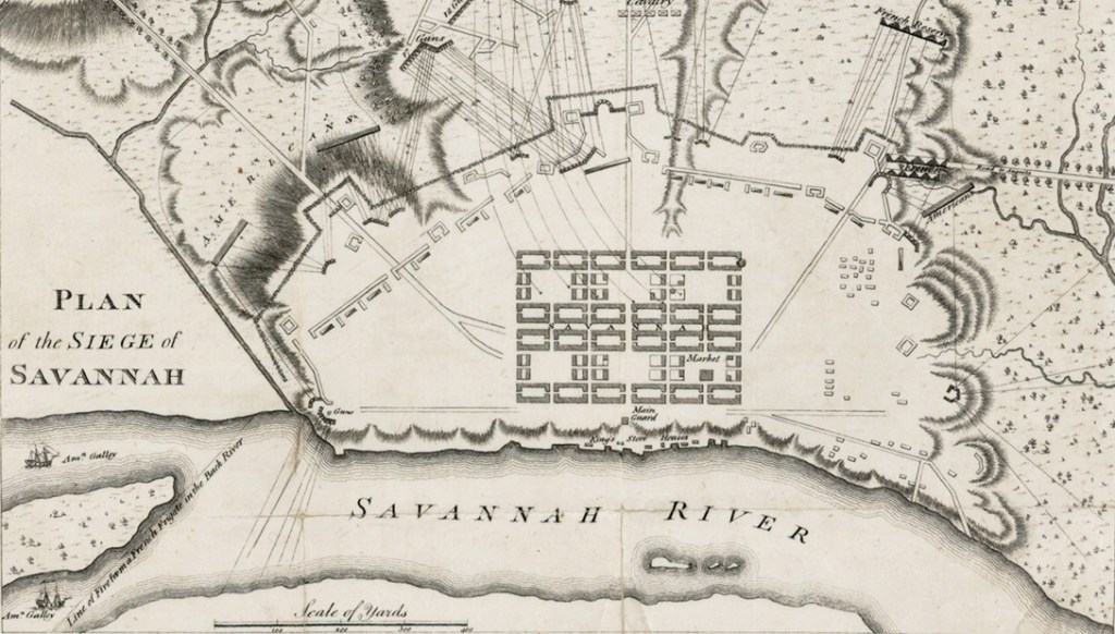
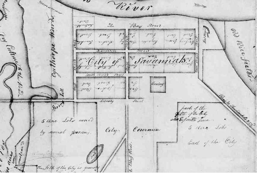
They are mysterious and old; the unexplained empty caverns beneath the plateau of Bay Street next to the 1905 City Hall where the ancient 1799 City Exchange once stood. They were referred to as stores, as vaults, as caves and as tombs; they were an embarrassment to the city and a curiosity to the public. They seem to have been viewed as a failure by both the architect that designed them and the man who took over their lease. They were erected to form the earliest retaining walls of today’s Factors’ Walk and seem to have been intended as general purpose (barrels, dray-cart, machinery, equipment or export) storehouses… but even as a later correspondent noted with derision, their purpose was never well-defined.
In February of 1839 City Council received a concerning report.
Savannah Republican, February 15, 1839
The old timber retaining wall east of the Exchange was rotting out. Over the next several months the idea of replacing the old wooden timbers with a more wall of greater permanence began to gain traction, encouraged by the local merchants.
In 1839 River Street was a newly-created, barely extant dead-end alley that was still only passable on its western half; the dray-cart alleyways of Factors’ Walk remained the most effective method of navigating the various wharf properties. This juncture in time found the Savannah Riverfront poised on the precipice between the quaint era of its early 19th century “stores” and “factors” vs. the more industrialized era of the mid-to-late 19th century River Street “ranges” and commercial superstructures, still fifteen years away. Where today we see vast stone walls and ramps in 1839 there was only sand and occasional timber retaining supports. In many ways, it was this endeavor that marked the beginning of the maturing era… but it came with its own set of growing pains.
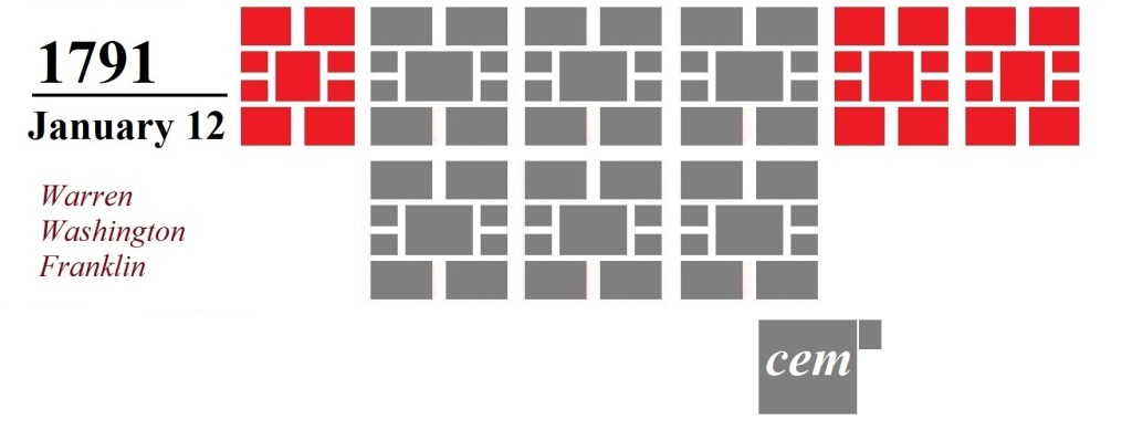
On December 5, 1839, City Council authorized a committee to entertain “proposals to build a permanent wall of brick or stone at the public walk east of the Exchange and west of Drayton street.” In the early months of 1840 notice was printed in the newspapers that the city was accepting bids for the construction of a permanent wall. And not just a wall… hidden in the small print lay the creation of a ramp as well. “The design is to carry up a brick or stone wall from the north east corner of the Exchange to a point on Bay street, having a street-way to the northward down the bluff.” In other words, considering that in 1840 River Street was effectively impassable east of Drayton, this ramp was designed to create a thoroughfare access to Bay Street and the east.
Daily Republican, 1840
Charles Cluskey (c.1808-1871) submitted a bid. In 1840 Cluskey was an up and coming architect in Savannah; by 1839 he had already designed the Sorrell-Weed House, and he would soon thereafter design the Champion-McAlpin-Harper Fowlkes House and the Sisters of Mercy Convent.
The easternmost vault displays a plaque explaining what little we know of Cluskey
On March 19, 1840 the bid offered by Cluskey, “was accepted, being for the smallest sum.” Several weeks later Cluskey sweetened the deal and evidently impressed the Committee by proposing to construct a collection of general storage facilities, or “stores,” within the wall. On May 7, 1840 Cluskey was awarded the contract to “have four stores constructed in that portion.” A month later, on June 3, more details were forthcoming as Cluskey offered “to erect four stores 40ft deep & 20 ft front each for $3000… under the proposed extended walk with proper walls & arched roofs.”
Daily Republican, June 8, 1840
Vault interior, HABS Survey image, late 1960s (Library of Congress)
Something that should be understood even today: These stores were not excavations; they were instead free-standing structures, built from the ground up, later to be in-filled to create the promenade above. Cluskey was advanced $1000 by the city in July and another $300 in October, but the work and all of its initial promise stalled. On October 9 a letter to the editor of the Daily Republican was published by a confused bystander:
“Editors: —In one of my morning rambles toward the Exchange, I made the enquiry, why has the building of the stores about being erected to the East of and adjoining the Exchange, and upon which our merchants were promised a flat roof and promenade been suspended? An individual near at the time replied—‘there is another story to be raised above that.’ I said I did not understand…. [He said] that overtures had been made to some of our merchants, endeavoring to impress upon them, what a convenient thing it would be, to run a range of stores facing upon the foundation now laid; where Cotton samples might be deposited, and counting rooms established…. I cannot positively say it is so. But enough has leaked out to alarm me.”
Nothing more is said in the record of any plans for a second story; this may have just been a rumor arising from the work stoppage. But as 1840 dragged deep into 1841 the City became increasingly impatient with the unfinished structures; Cluskey, in the mean time, was distracted with other contracts like rebuilding the city’s cisterns and the construction of the new jail building south of Liberty Street.
The editors of Savannah Daily Republican chimed in by the late spring of 1841, remarking of the abandoned project east of the Exchange:
Savannah Daily Republican, May 2, 1841
In the Proceedings of Council on July 15, 1841 it was “Resolved, That if Mr. C. B. Clusky does not complete the work at the east end of the Exchange, so far as the filling over the arches of his stores and the completion of the work by the 30th July, that Council will order the work done at the cost of Mr. Clusky.”
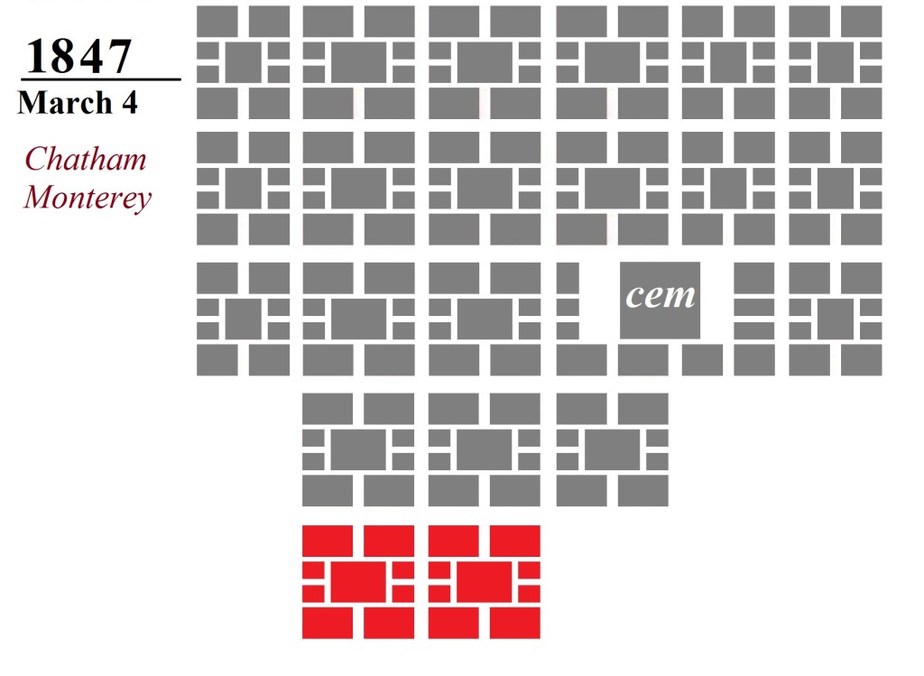
Of varying sizes… due to the slope of the ramp the vaults taper in size from west to east; easternmost (left) is the smallest, westernmost (right) largest
The City Council and the newspapers weren’t the only parties to find the situation unacceptable; even average citizens were becoming annoyed over the stalled project. Days after City Council decided to act a correspondence to the Editors of the Republican was published, railing against the immense complexities of building “a simple Wall,” and making the first derogatory reference to the vaults as… “the tombs.”
Daily Republican, July 20, 1841
New York’s “Tombs,” 1870s engraving (Wikipedia)
The references above would not have been lost on a contemporary audience. In 1838 the City of New York had attracted national headlines with the erection of a highly-stylized prison; an over-budget and over-schedule architectural folly whose outward resemblance to an ancient Egyptian necropolis had elicited a nickname within the vernacular as “the Tombs.” The term had become something of a running joke across the nation to describe any architectural project subject to exorbitant cost overruns and work delays—in short, any wasteful architectural project exceeding its grasp. Now Savannah had its own example of the “tombs,” sometimes referred to in terms of the New York folly… but just as often referred to in the more literal context of the nearest graveyard.
Days following the above complaint, the July 31 Savannah Daily Republican received another letter they confessed that—due to language—they could not publish in full, but instead chose to carefully paraphrase: “The communication recommends that the caves at the east of the Exchange, should be made literally into tombs, in which to bury the present dynasty of Aldermen. As the writer reflects rather severely upon the Board, we must decline its publication. The manuscript will be returned or committed to the ‘barrel,’ as the author may desire.”
Vault #3
Cluskey appears to have not replied to the Aldermen’s demand (and evidently paid little heed to his newspapers), for by the September 23 Proceedings of Council it was “Resolved, That the Committee on Public Buildings be instructed to have an interview with Mr. Clusky, the contractor for the wall and buildings at the eastern end of the Exchange, and ascertain from him whether he intends completing said buildings and walls forthwith: and that said committee be instructed, in case that he does not give satisfactory evidence of completing said improvements as speedily as possible, then that said committee be authorized to contract with some other workman to finish it at the proper costs of Mr. Clusky.”
By October 7, the Committee had “had an interview with Mr. Clusky about completing the work on the brick buildings adjoining east of the Exchange, who promises to have the work all done and completed by the last of the present month (October).”
Yeah, that didn’t happen. Soon after the New Year rang in on 1842, the January 11 Savannah Daily Republican—waxing poetic with tongue firmly in cheek—published an editorial on the issue of certain city construction projects that seemed “forever in progress….”
“We are compelled to refer again to the catacombs near the Exchange, commonly called ‘THE TOMBS.’ These structures are chiefly remarkable for their antiquity, and the date of their commencement is almost lost in the mystery of past time. The Arab, when he makes his evening fire against the fallen columns of Palmyra and Balbeck, fancies that it was a race of giants who erected such imposing wonders…. Are we pygmies that we cannot take up our hammers and chisels, and complete what a race of people have begun who will be pronounced our superiors unless we show our prowess at once? Let them be finished, and these ‘doleful sounds’ shall be heard no more.”
By January 27, 1842 the Committee on Public Buildings noted with exasperation that there was nothing in the contract with Cluskey to compel an end date to the endless project. “They had several interviews with Mr. Clusky on the subject of the work he contracted to do for the City East of the Exchange. The Committee have also examined the memorandum of agreement between the Mayor and Aldermen of the City of Savannah and C.B. Clusky to do said work, and they find nothing in that instrument to compel Mr. Clusky to complete the work within any definite time. The Committee have endeavored to remedy the defect in the original agreement, but have not succeeded as well as they could wish. A note addressed to the Committee is all they could get from him. In that note Mr. Clusky promised to have the work complete within ninety days from date.”
This also did not happen. It seems that Cluskey was otherwise overdrawn; a month later, in March of 1842, he was essentially sued by John Dillon, and a lien was placed Cluskey’s twenty-year lease on the stores.
Daily Republican, March, 1842
In the wake of the forced sale of his lease, Cluskey officially abandoned the project he had essentially abandoned two years earlier. By August 25, 1842 the Committee remarked that the work “east of the Exchange has not been performed,” and was now considering “said contract or understanding null and void.”
On August 31 another infuriated Letter to the Editor appeared in the Republican:
“Improvement East of the Exchange, or more familiarly known as the tombs. Ah! here is indeed something to boast of, a monument like the Egyptian Pyramids, the wonder of the present age and a puzzle to the future. These tombs, however, cost $2,367 without any useful purpose to the city; the builder has the use of them for 20 years, and was paid this large sum to induce him to construct for his own private benefit these buildings on the public property!”
Two weeks later, by September 8, the City Council officially recognized a new contractor on the project: William Walker. “The Committee on Public Buildings, to whom was referred the matter of contract or understanding with Mr. C. B. Clusky, for furnishing materials, and building and completing the brick vaults East of the Exchange, and for furnishing and putting up an iron railing on the wall of said vaults, with powers to act: – Report, That the said Mr. C. B. Clusky has made a surrender of said job to Mr. Wm. S. Walker, who has given bond and security to complete said work by the first of September next.” Almost two and-a-half years after Cluskey had been awarded the original contract, Walker was now the chief builder and John Dillon now the holder of the lease.
Walker’s contract to complete the erection of the structures by September of 1843 seems to have been met; there does not appear to be any completion notice in the record, but neither was there further haranguing within the newspapers. The following year, in the July 25, 1844 Proceedings of Council, the “petition of John Dillon, asking Council to pave over the ground East of the Exchange, above the stores erected by C. B. Clusky was referred to the Streets and Lane Committee.” So by the late summer of 1844, the finishing touches were at last being placed upon the project as lessee Dillon was seeking to create and pave the surface level above the vaults.
Cluskey Vaults as seen from the Gamble Building balcony, 2024
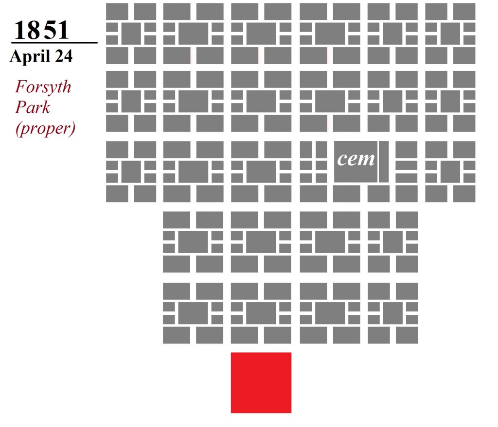
The end result (following the four-year saga) was not at all what the City Council had originally envisioned, and the general consensus was that the finished product—vacated by its own architect—was an unattractive series of holes in a wall. Four years earlier these curious structures had been maligned as “the tombs;” the nickname stuck. By 1845, “Tomb No. 4” had a working tenant.
Savannah Daily Republican, November 19, 1845
In the decades following their completion the “tombs” became an odd but unmistakable landmark of the town, fulfilling the 1842 prophesy that they would become “a puzzle to the future.” Under the heading of “Coast Survey”, the January 7, 1851 Savannah Daily Republican remarked that “Mr. Boutelle… has contracted with Mr. G. Butler to erect a small temporary observatory over the Tombs east of the Exchange, for the purpose of making observations for latitude and longitude.”
In 1855 and 1856 the vaults played a minor (but documented) role in the construction of the Abercorn and Barnard Street ramps, as the city paid John Dillon both years for the storage of barrels of lime used in the projects; the Mayor’s Annual Report of 1855 records payment of $30, and in 1856 $72. By the following year John Dillon had either surrendered or sold his lease; the 1857 Mayor’s Annual Report finds the tombs had prematurely defaulted back to the City. In 1857 the City recorded its first tenant of the tombs—no less than the US federal government, paying $225 for rent of the vaults. The US government continued its lease of the vaults until 1861.
The February 5, 1859 Savannah Morning News found “John Stoddard, owner of the wharf lots 7 and 8 (Stoddard Range), East of the Exchange, desirous of improving the stores by adding another story, asking the privilege ‘to throw a light and strong bridge from the terrace, now known as the Tombs, toward the platform of the store now occupied by Wm. Battersby & Co., said bridge to be 15 feet above the pavement below;’ also asking ‘a perpetual lease of two of the arches, at a nominal rent, in order to construct therein water closets, which will produce considerable revenue to the city.’”
So… had Stoddard just offered to turn two of the vaults into restrooms? There is no follow-up that I’ve found, so I think the answer to whether the Cluskey Stores ever became restrooms is probably no. While it is clear the city never knew what to do with the properties, they did not necessarily trust anyone else with them, either. It is important to point out that even when the vaults were under lease, they were still city-owned properties… which would have rendered the city criminally liable for any illegal activity conducted within.
In February of 1869 the City Council rejected an offer by Ketchum & Hartridge to buy the lot east of the Exchange, “including the tombs beneath.” While admitting the vaults and the promenade above were “an irregular, ill-looking affair,” this generation of the City Council was unsure it even had the right to sell this city property. Interestingly, the city’s nebulous claim to Factors’ Walk was challenged twenty years later, but it was not this block. In 1887, following a three-year legal standoff with the guano company of Wilcox & Gibbs, the city relented and sold the block of Factors’ Walk west of the Exchange. That action resulted in the prompt demolition of that block of Factors’ Walk, an act which proved controversial; the city did not repeat that error east of the Exchange.
Still around: detail of the vaults from the 1888 Sanborn Map, delineating them as “Storage Cellars”
The small, bricked-up vault to the east of the others
Over the subsequent decades the city made modest rents from the vaults east of the Exchange, as recorded in the Mayor’s Annual Reports. The “tenements in the tombs” fetched $273.58 in 1873, $291.63 in 1874, $175 in 1879, $250 in 1883, $150 in 1887, $275 in 1893; in 1888 they housed disinfectants while in 1899 Ferst, Sons & Co. were allowed to rent them “for the purpose of storing fireworks in original packages.”
Already mentioned is the tapering geography of the vault shrinking in size up the incline; the smallest vault today was not the end. Sometimes referred to as four in number and sometimes as five (recall the 1842 Sheriff’s Sale notice above), the vaults have indeed lost one of their number over time; the easternmost “mini vault” was subsequently bricked up, leaving today only the larger four. The footprint of this smallest vault, however, is still clearly visible in the wall today.
Were the Stores ever used to hold enslaved persons?
As a coda, it is worth taking a moment to address a bit of popular lore that grown spread around the vaults in recent years. Sometimes a story fits around a preconceived notion so beautifully the conclusion to be drawn is that it simply has to be true. I think of my friend Marcus, who years ago gleefully shared with anyone he met that “Daufuski” was derived from a Gullah pronunciation of “the first key,” meaning the first island of South Carolina’s coast. Of course years later I learned that Daufuski was a Creek name, so while Marcus’ explanation was really cool and made logical sense… it was simply wrong.
This analogy seems to me not unlike the specter of the Cluskey Stores. Pausing before them—much like standing at the door of an old ruin—one is overtaken by an ominous sense of wonder. People whisper tales of slaves possibly being held here, and it’s easy to believe… for a moment, anyway. But much like Marcus’ story, the facts stand in the way of a good story. So to answer the question above… did the Stores ever hold enslaved persons? My conclusion is no, for three reasons:
Wrong time period. The Cluskey Embankment Stores were erected more than four decades after Savannah’s Atlantic trade had ceased… essentially 45 years too late. Congress outlawed the United States’ involvement in the African slave trade effective 1808, but even by this date Georgia was no longer active. Savannah’s large-scale Atlantic slave trade lasted a total of 23 years, over two periods: from 1766-1774 (accounting for roughly 10,000 individuals) and again between 1784-1799 (roughly 7500); in 1798 Georgia’s State Constitution barred the Atlantic trade. More can be seen on Savannah’s role in the 18th century African Trade in a separate post, but to be clear, there is no part of Factors’ Walk that dates to this era; the riverfront that we see today arose entirely out of the next century—River Street, for example, didn’t have any beginning before the 1830s. With the Cluskey Stores erected in the 1840s, claiming that they held enslaved Africans is not unlike claiming a particular Model-T was the one that John Wilkes Booth made his getaway in… it conflates different time periods.
Never once in their recorded history does the word “slave” ever enter into connection with them. Because of the beleaguered construction history of the Cluskey Stores, in many ways this represents the best-documented single block of either Factors’ Walk or River Street. This was the first and oldest permanent Factors’ Walk retaining wall… and given this experience it would be another decade before the City Council would attempt to contract retaining walls for the bluff again. Archaeological surveys conducted within the structures have yielded no evidence to suggest occupation by enslaved persons, and never once in their recorded history is the word “slave” associated with them. Had such a public venue in so widely a used commercial thoroughfare held human beings this would have attracted attention somewhere in the record. No one was coy on the subject of slavery—there were numerous well-publicized sites in town where enslaved persons were kept and sold in this very time period, many of which are discussed at length in another post. I would suggest claiming this was a site where enslaved persons were held is a genuine disservice to still-existing sites that were.
Impractical, possibly even illegal.Even looking at the structures today, containing people within them seems somewhat impractical. Also, holding enslaved persons here might have been illegal. As mentioned above, regardless of who leased the properties over the years, the vaults remained city-owned properties… which would have rendered the city criminally liable for any activity conducted within. The commercial lockup at Bryan & Habersham, the Pulaski House Hotel basement and the Wright slave yard were documented places where interstate slaves were held, but these were commercial/private entities. As to any argument the vaults might have played a role in housing trafficked persons from the Wanderer in December 1858, I will point out that the vaults were actually leased by the US federal government between the years of 1857-1861… rendering them pretty much the worst conceivable place in Savannah to consider hiding illegal persons.
After researching these Cluskey Store vaults for years one conclusion is quite clear: these structures were viewed as a colossal blunder almost from the start; left unfinished and to serve no clear purpose. They remained something of a joke in subsequent decades, referred to as arches, vaults, holes, caves, tombs, “a melancholy monument of inefficiency,” or “an ill-looking affair”… possibly proposed in 1859 for restrooms; in subsequent decades storing disinfectants and fireworks. Ultimately, they remain enigmas to us as much as they did to the generation that witnessed their construction, fulfilling the prophesy of that 1842 correspondent that they were to become “a monument like the Egyptian Pyramids, the wonder of the present age and a puzzle to the future.”
The four surviving Cluskey Vaults in 2024Interiors of the two vaults to the eastInteriors of the two vaults to the west
One of the plaques greeting a visitor at the vaults today
One of the plaques greeting a visitor at the vaults today
Of trains & tracks, of stones & pavers, of walls & ramps, of River Street & Factors’ Walk… Here’s the truth about today’s riverfront: whatever building you’re looking at, whatever wall looms before you, whatever stone that catches your foot, it probably came a little later than you think.
Once upon a time—not long ago—there was a train to be found on River Street. The River Street Rambler was a full-sized diesel engine which would appear with little warning at the eastern or western parameters of River Street, slowly and politely squeezing its way through the length of the street twice a day on its delivery errand to or from the industries near Ft. Jackson, then disappearing as abruptly as it had manifested, a psychedelic blur of colors leaving every passer-by unsure of what he or she had just witnessed. A restored, brightly multi-colored engine; in lieu of a horn it blared out amiable dixieland or country music while its conductor waved to the bystanders like a beauty pageant contestant in a slow passing parade. Behind the engine followed the familiar (though abbreviated) array of freight and gas tanks, the latter of which were plastered with all the standard toxic and flammable label warnings… I was always amused by the dichotomy of this schizophrenic train with its happy engine and toxic pull-behinds. Twice a day it slowly wreaked havoc on River Street, forcing cars on the narrower eastern end of River Street to back up entirely, finally retired on March 31, 1999.
Images of the River Street Rambler in action
River Street’s streetcar, 2009-2015 (Flickr image by ciambellina)
A decade later the city purchased an old Australian streetcar and retro-fitted it to run on the tracks, and for a few years it too traveled up and down River Street, offering free public transport… a convenience, in the words of Hamlet, “more honored in the breach than in the observance.” Mechanical issues more often than not kept it sidelined and inside its little western-end housing compartment almost as often as it was allowed out. Encountering many of the same logistical and traffic difficulties as the train, the trolley was quietly retired in 2015. In the wake of the the Plant Riverside development between 2016 and 2020 the tracks on the western end of River Street were removed altogether.
Tracks and pavement, both 20th century
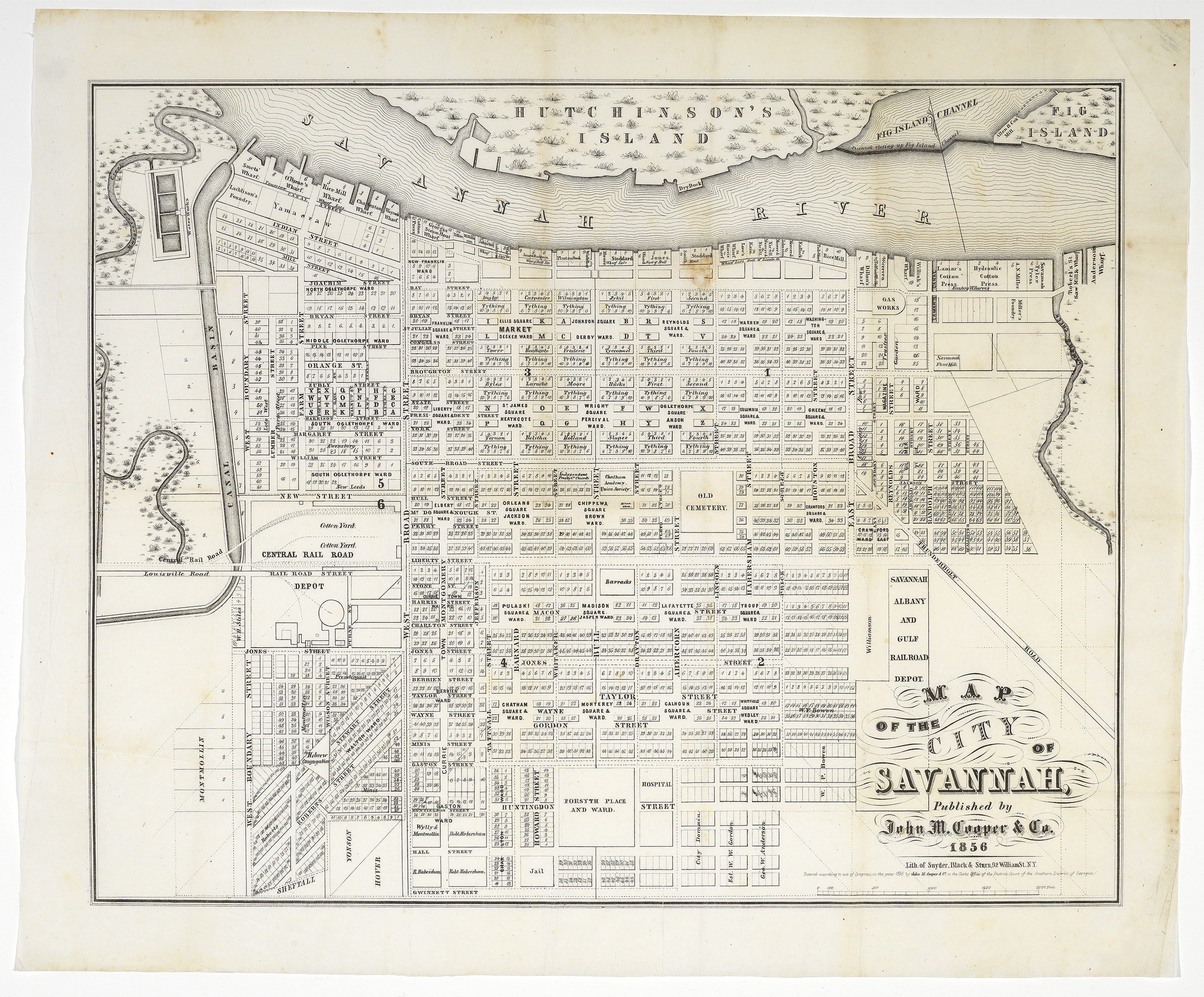
The tracks we encounter today are remnants of the 20th century. The Central of Georgia first laid tracks on River Street in 1889, but only from West Broad to Bull Street, terminating behind the City Exchange. “The ringing of the bells of the locomotives as they pass along the river front as far as Bull street is a new sound in the old business portion of the city,” boasted the September 28, 1889 Morning News. “A siding has been put in on River street, between Barnard and Whitaker, and another between the latter street and Bull Street.” The tracks remained a terminus at the City Exhange until 1898, when rights were finally secured to traverse the Rice Mill at the East Broad Ramp and River Street at long last became a passable thoroughfare, but even these 1898 tracks were not the ones we see in place today. Instead of any one single line, the River Street was a loading and switching zone; multiple tracks diverged, ran parallel to one another, merged or stopped altogether.
Choo-choo! 1898 Sanborn Map demonstrating some of the parallel, merging, diverging & terminating rail lines on River Street
The Belgian block pavement that today spans the length of River Street is also 20th century. Portions of the street were paved with cobblestones between 1878 and 1881; as the August 1, 1881 Morning News reported, the city was “engaged in paving River street where needed and have it in thorough order as far east as Lincoln street.” In 1905 the city engaged in a more expansive repavement of cobblestones on River Street, but by the mid 20th century that pavement had largely gapped, washed out or simply gone to cobblestone heaven, leaving the street barren or reduced to gravel. The 1973-1977 era saw the birth of our current River Street, with the construction of Rousakis Plaza and a complete physical rehabilitation and commercial revitalization of Savannah’s waterfront; this era was when River Street saw the bulk of its current Belgian block pavement installed. Simply, in the modern epoch there was a River Street before the 1970s renewal and a River Street after the renewal; below are some images taken during the renovation era. All three images are from the Savannah Morning News.
River Street renewal project in progress, 1970s (all images: Savannah Morning News)
Modern stamped flooring of Factors’ Walk
Similar to River Street, Factors’ Walk was also over the years reduced to a floor of gravel, weeds and displaced stones. Today the street is paved end to end with stamped concrete sheets replicating the appearance of cobblestones. Much like the tracks and the Belgian blocks on River Street, the current Factors’ Walk pavement is not old, but hearkens back to an earlier antecedent.
So if the track isn’t old, the River Street pavements not old and the Factor’s Walk flooring little more than an embossed stamp, what is old?
Cobblestones! The cobblestone pavements on the ramps to River Street, carefully maintained (and occasionally relaid here and there) by the city. Initially laid down with the creation of the ramps in the 1850s, these pavements have been removed, altered, restored and relaid on any number of occasions but still may be considered the oldest existing pavements in Savannah.
Cobblestone pavements: Lincoln Ramp (left), Abercorn Ramp (right)
In my SCAD Intro to Video class we would classify this as a jump-cut: Barnard Ramp, where the 19th century cobbles intersect with the modern stamped concrete pavement of Factors’ Walk, 2024
Chatham County-Savannah Metropolitan Planning Commission images of the Factors’ Walk flooring being laid down (Courtesy of City of Savannah Municipal Archives)
Light & Dark…
West Factors’ Walk, 2024
River Street and Factors’ Walk… two sides of the same coin. One bathes in the sunlight on the north side of the old factorage buildings, while the other seems to hide away in the shadows and the narrows on the south side of the structures. One is visited, the other is passed by. One features stores, bars, art galleries and every commercial delight, the other houses leaky air conditioning units, back-alley doors and an occasional misplaced business that look like it got lost on the way to River Street. One is a street with pleasant smells, the other is a lane with frequently cantankerous odors. These two conflicting personalities form Savannah’s historic riverfront and beg the questions: Exactly what is River Street and how did it come to be? On the other side of the buildings, what is Factors’ Walk and what role did it play in Savannah’s history?
First of all, some perspective.
Savannah was founded in 1733
River Street didn’t exist before 1833, and doesn’t appear in any advertisement before 1849
Factors’ Walk doesn’t appear in print before 1810
West Factors’ Walk can be as dark as night: 100 block west on a bright June day in 2024
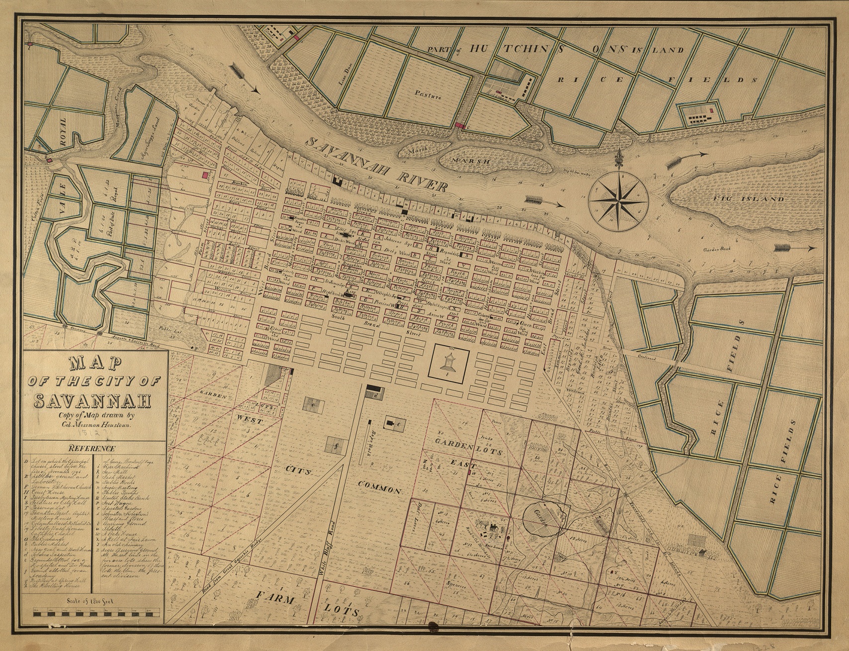
As far as I can tell and far as research would suggest, there is no physical vestige of any building, wall or construction north of today’s Bay Street predating 1800. The riverfront we see today was a creation of the 19th and 20th centuries, without a trace remaining of its first seven decades. The next seven decades, however, saw a constantly churning, ever-changing and breathing entity morphing from the quaint simplicity of stores to the peak of 19th century industry in enormous commercial ranges. Savannah’s 19th century riverfront was a constant work in progress, witnessing economics and priorities shift by the generation. Buildings came and went and River Street evolved from a notion, to a dead-end street, to a fully fledged thoroughfare by 1898. While it might seem impossible to imagine our riverfront without River Street today, to anyone in 1800 a street running cleanly through the disparate and privately owned commercial wharf-lots would have been equally unthinkable.
Undated (c.1890s) William E. Wilson view of Factors’ Walk at the Archibald Smith Stores, looking west to the Abercorn Ramp and Jones Building (GHS coll. #1375PH)
1734 Gordon map detail
At Oglethorpe’s arrival in 1733, the would-be Savannah settlement was poised upon a 40 foot cliff. Below the bluff was a shore line evident only at low tide, referred to shortly thereafter as “Yoakley Bank,” named for James Yoakley, captain of the James, which was the first ship to successfully navigate the river, claiming a prize offered by the Trustees.
100 block west; East Factors’ Walk is largely open and airy, but West Factors’ Walk can be dark and claustrophobic
But while the 40-foot elevation proved in advantage in the consideration of defense, important at the founding of any settlement, it was an “uphill battle” in the attempt to develop commercial trade. “The Town of Savannah is Subject to several Disadvantages, in its Trade, from the want of a Wharf & Landing Place,” John Brownfield remarked soberly in 1737. (Colonial Records of Georgia, vol. XXI, p. 325) In 1739 Andre Duchee, a potter, was the first to attempt a storehouse below the bluff. But while the man knew his clays such an expertise did not necessarily extend to construction. The Trustees’ loyal scribe William Stephens was not impressed with the result, writing at the time that the structure “did not promise any long Duration, for divers Reasons which I thought were apparent.” (CRG IV, p. 353)
In 1744 Habersham & Harris became the first private enterprise in Savannah to establish a trans-Atlantic commercial trade, planting the seed of commercial buildings that would eventually take root beneath the bluff. A generation later, by the 1790s, the first buildings of Robert Bolton’s Commerce Row rose above the bluff, and in the years that followed, the area around it gradually began developing into commercial wonderland of wharves and stores.
In 1804, however, a hurricane showed how vulnerable the city’s trade was to the wrath of mother nature.
“On Saturday last we experienced one of the severest gales of wind that has happened within the recollection of our oldest inhabitants. In fact few, very few of us, can recollect ever to have seen anything, the effects of which was so destructive, as has been the late Hurricane…. The wharves from one end of the city to the other were torn up, and almost every store which was erected at any distance from the foot of the bluff, was either totally destroyed, or much torn to pieces, as to spoil everything contained within them. Every vessel in the harbor was thrown upon the wharves, except such as were totally destroyed, and large ships are laying on some of the highest wharves. There was no passing from one wharf to another; lumber, cotton, tobacco, hogsheads of rum, sugar, and in fact every article of domestic and foreign produce were strewed from one end to the other.”
– Colonial Museum & Savannah Advertiser, September 12, 1804
Undated (c.1890s) Wm. E. Wilson image of the Smith Stores (Abercorn Ramp) looking east (GHS coll. #1375PH)
How it differs today: similar view in 2024… a few less trestle bridges
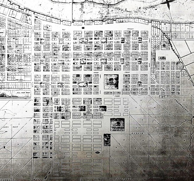
The hurricane of 1804—and more importantly, a reliance on frame structures—helps to explain why nothing from the 18th century riverfront still exists. The block of Commerce Row—including the old Habersham & Harris structure, the riverfront’s early 19th century most recognizable building—was torn down in the summer of 1889, and with that the last stones even potentially dating to the 18th century riverfront were wiped away before the advent of the 20th. The bulk of the range buildings lining today’s riverfront date to between 1809 and 1877, which we will see in part 3.
The Riverfront, as depicted in an engraving featured in a George Nichols advertisement in the 1884 City Directory
Factors’ Walk: the original River Street
Light emerges at the western end of Factors’ Walk, 2024
As Savannah began to emerge from the depression of the 1820s, the spark of industry and commerce began to glow again over the decade of the 1830s. In 1800, only one building beneath the bluff was unquestionably made of brick or stone. By 1846 all but one of the Bay Street/River Street buildings were made of stone or brick.
“Let the most superficial observer of events for the last five years, who has resided in Savannah, look about him and see the changes which individual enterprise has made…. Five years ago, you might have rambled along the Bay, and seen many of the then existing stores closed and unoccupied… almost every building in a state of decay. Now you can see the finger of improvement busy at every turn you make.”
– Georgian, February 28, 1839
So what, exactly… is Factors’ Walk?
In the summer of 1884 the Savannah Morning News wrestled with this very quandary. As ownership of the Factors’ Walk block between Bull and Whitaker and the old Commerce Row was being challenged in court the newspaper approached Savannah historian Isaac Beckett to learn more of this already-ancient thoroughfare and to better understand its place in riverfront history. “Mr. Beckett was found in his office, seated as his desk, surrounded by a dozen voluminous books of record and a map of the city spread out before him,” the July 6, 1884 Savannah Morning News reported. “’Factors’ Walk,’ he said, after listening to the reporter’s inquiry and consulting his memmoranda, ‘is that narrow street below the edge of the bluff, in the rear of the wharf lots. It derived its name from the fact that in former years many of the leading factors and commission merchants had their principle business offices opening upon it.’” This was an apt description in 1884 and remains so today… though as will be seen in the next post, ultimately met, these factors of old can’t help but disappoint a bit.
The old alleyway of Factors’ Walk may be better understood to us today as a prototype of River Street, a commercial thoroughfare quickly rendered obsolete as River Street was carved out of the privately-owned wharf lots in the following generation. Frankly, it quickly outlived its usefulness, only to become something mysterious, romanticized and little understood only two generations after is creation.
“Factors’ Walk” first appeared in print in a September, 1810 Savannah Republican advertisement.
Earliest reference to Factors’ Walk: Republican and Savannah Evening Ledger, September 11, 1810
Factors’ Walk 100 block east, taken from Upper Factors’ Walk (lower level left), 2024
At the time of the above advertisement in 1810 the riverfront was an impassable mass of wharves, with no access to cross from one property to the next; even the north ends of the buildings were of varying depths, making egress below the bluff from any one property to the next impractical and at some locations impossible. Factors’ Walk developed as a commercial alleyway on the south side of the buildings—a thoroughfare passageway affording egress to the other wharves—a modest dray-cart alley that gradually evolved into dual levels and catwalks, platforms and fragile trestle bridges as the modest buildings of the early 19th century began to give way to the more complex superstructures of the mid-19th. So Factors’ Walk was River Street in the generation before River Street existed.
The street today known as River Street was only slowly carved out of the wharf lots at the bottom of the bluff. It does not appear in any advertisement before 1849. Here’s the first advertisement to reference River Street, by a manufacturer either within or behind Commerce Row:
Savannah Republican, August 30, 1849
Even as late as the 1853 Vincent Map, Factors’ Walk was depicted, but River Street was not; the latter a space occasionally still blocked by longhouses and dead-ending entirely at the Steam Rice Mill. It took several decades of realigning these property lines to result in the River Street we see today.
1853 riverfront; no walls and ramps fall steep & straight. FACTORS’ WALK is depicted; River Street is… just not a thing anywhere here
One crucial observation about the riverfront presented by the 1853 Vincent Map above is that all of the ramps leading down from Bay Street run straight. This is weird and deserves additional comment… the CURVED RAMPS we see today seem to have been created after 1853 with the Cash ramps.
By the 1884 Sanborn Fire Insurance Maps, much had changed, and this engineering effort included the massive retaining walls we see today. One thing that remained was that Rice Mill, still blocking River Street, thirty years later. Not until 1899 was the street opened through the Rice Mill property.
1884 Sanborn, west riverfront… (CURVES!) so, curved ramps and retaining walls were now a thing1884 Sanborn, east riverfront… so River Street still dead-ended at the Steam Rice Mill
The riverfront began to assume the profile we recognize today with the 1850s, a decade which saw no fewer than five of the current superstructures erected, the ramps take on their current form and the entirety of the bluff walled from one end to the other. The retaining walls of the bluff are imposing. Anyone who walks the length of Factors’ Walk can’t help but be impressed—even a little bit intimidated—by them. When were they built? Who built them? And whose idea was it to alter the earlier straight ramps leading down to the wharves into curved descents?
Tucked away within the oldest Factors’ Walk wall, east of today’s City Hall, are a series of peculiar cavernous openings—the Cluskey Embankment Stores. Much like Superman’ s alter-ego, this reversed, oddly (today) westward ramp stands out today as the one outlier, the one and only alternative to the eastward-running ramps of the 1850s that would follow… but this was the first and the model that the 1850s Cash Ramps would ultimately embrace.
In February, 1839 a special committee reported to City Council that the old retaining wall east of the Exchange—made of timbers—had rotted out and urged a more permanent form of retaining wall. On December 5, 1839 the City Council authorized a committee to accept “proposals to build a permanent wall of Brick or Stone,” which gave birth to the first and earliest permanent walls for the bluff, as well as the first graded ramp connecting Bay Street to River Street. We’ve already visited the complicated history of the Cluskey Stores in the previous post; I include a brief recitation here because one of the consequences of the debacle of the Cluskey Stores’ never-ending construction was that it would be a full decade before City Council opted again to build retaining walls for the bluff (and perhaps the reason it later adopted—literally—the opposite direction for the subsequent ramps).
But by 1852 the embers of industry were alighting. The April 2, 1852 Savannah Republican called for action in an editorial under the banner of “City Affairs.”
“The River.—We are glad to perceive that the River begins to attract the serious attention of our citizens. It is full time it should—for, if something effectual is not soon done, there may be those now living who will be enable to point out in after years where the River ‘once was.’ It is a subject in which the present property-holders in the city are more interested, than in any other that is now or can be brought before them…. Now is the time to direct our thoughts earnestly to this great and important undertaking…. Let us go to work, and accomplish it, no matter at what cost.”
Riverfront, circa 1901 (Library of Congress)
The retaining walls on today’s ramps were works of civil authority, and as such, many of the walls bear the mark of the mayor that green-lit these public works. The fact that almost all of the walls bear the imprint of Mayor Edward C. Anderson (1854-56, 1865-69, 1873-77) speak to the relatively narrow windows in which most of today’s walls were erected. As mayor he presided over the only two periods that seem to have seen significant constructions of Factors’ Walk walls.
ECA gone crazy; okay, yeah, we gotcha, Ed Anderson
These retaining walls were contracted public-works projects, found only sporadically within the Proceedings of City Council or Mayors’ Annual Reports. The first references to retaining walls are subtle. Some early work building stone walls was carried out in 1853, the same year of the Vincent Map, and the year after the Republican urged action. One full decade after the completion of the Cluskey Wall, in April, 1853, the City Council authorized the building of a “stone wall along Bay-street.” By December, the city recorded an expenditure of “$1128.12 for continuation of stone wall under the Bluff.” (Savannah Daily Georgian, December 6, 1853) What this 1853 work was, and where, is unclear.
Some of the historic staircases (or “scare–cases”) of River Street and Factors’ Walk…
The winding staircases of Factors’ Walk, 2022
East end: From River Street to Factors’ Walk, 2024West end: From Factors’ Walk to Williamson, 2024
The majestic (and occasionally terrifying) Jefferson Street Staircase on West River Street to Williamson Street, 2024
The earliest ramps: Lincoln, Abercorn and Barnard…
Panoramic view of Factors’ Walk at the Lincoln Ramp
Factors Walk at Lincoln Ramp
The Lincoln Ramp represents the first, oldest and smallest of the 1850s ramps, but it established the design the others would follow. The walls for the Lincoln hill were begun in 1854, a contract won by Irish stonemason and contractor Michael Cash, a man whose documentary record—despite his name appearing on so many of the walls—is rather light. He was born in County Wexford, Ireland in 1833 and emigrated to Savannah in or about 1852. By 1867 The Daily News and Herald remarked that Cash produced mason work that was “performed the work in the most substantial style, and of the best material.” In addition to the walls he later would win city contracts for various street pavings and sewer construction, but his public works career in Savannah began with the Lincoln Street Ramp. In November of 1854, the Street and Lane Committee’s report for the year recorded: “Paid Michael Cash, work on stone wall foot Lincoln – $1577.86.” (Savannah Daily Georgian, November 22, 1854) The Lincoln Wall’s railing was produced the following year; it cost $243.50 and was supplied by Stibbs & Davis, blacksmiths who maintained a shop at Bull & State Streets on Wright Square. “Paid Stibbs & Davis, for Rail’g around Wall, Lincoln street.” (Mayor’s Annual Report, 1855)
The Lincoln Ramp: the first (and smallest) of the Michael Cash ramps, in 2022
The full cost breakdown shows just how much ballast and lime was required for the task of one ramp wall. The expenditures, as recorded in the November 22, 1854 Savannah Morning News:
The above reveals that no less than 1957 tons of ballast were required for the walls; even $34 went into the expense of “hauling out dead animals.” One might also notice the reference to the Abercorn Street wall: “Paid Michael Cash, work on stone wall foot Abercorn street – $418.61” By this it is clear that by late 1854 the Abercorn wall was just beginning. A week later the Street and Lane Committee urged “the continuance of the work on the stone wall, foot of Abercorn street.” (November 30) By the Mayor’s Report for the year 1855, the “completion of the stone wall at the foot of Abercorn street,” resulted in a cost of $6,047. (November 23, 1855 Savannah Morning News)
No less than 1968 tons of ballast went into the Abercorn Wall, and probably no less than 4000 tons for both ramps. Carlton & Parsons was paid $215 for 200 barrels of lime; for anyone curious, that’s about 8400 gallons of lime. The cost breakdown for the Abercorn Ramp in the Mayor’s Annual Report for 1855, pages 26-7 is mostly identical to the above, just a bit easier to read.
One will note above that John Dillon was paid $30 for the storage of lime. As the leasee of the Cluskey Stores in 1855, it’s not hard to guess where that lime was probably stored….
Factors Walk at Abercorn Ramp
The stones used to create the walls and pavements were purchased ballast from ships, a fact certainly well known and oft-repeated by most tour guide these days, but here we are provided with a list of vessels from which individual stones came. The Sardinia provided 115 tons, the Silas Green contributed 240 tons to the Abercorn Ramp, the Chaos arrived at an agreement to sell 170 tons to the city for $47.50. In understanding these small points and appreciating this context, the walls of today become more than simple stones. There is something intriguing about the idea of pointing to any random stone on the ramp and realizing that there is an 8% chance that it came from the Eli Whitney, or a 16% chance it came from the accumulated stash of one J.G. Mills.
Panoramic image of the Abercorn Ramp, 2022
In regards to the Barnard Street hill, in both March and November of 1854 Adam Short was named as its contractor; he was paid $1500 “on account of his contract for building wall foot of Barnard.” In 1853, Adam Short was listed as a “Contractor and Builder,” with an office on “Broughton st., next to St. Andrew’s Hall.” (Savannah Evening Journal, June 15, 1853) His advertisements as a “master builder” appeared daily within the newspapers of 1853 and 1854.
Savannah Daily Georgian, April 20, 1853
It seems that any work he contributed was ultimately unfinished, for by February 7, 1856 City Council “Resolved, that the Committee on Street and Lane be authorized to progress and complete the stone wall and improvements at the foot of Barnard street.” What might remain today of Short’s 1854 wall is unclear; however, there is a section of western slip wall that is clearly different from the other ramp walls.
Not like the rest… the highlighted section came either before or after the rest of the current ramp
Whether this is a remnant of Short’s wall, or whether any portion of Short’s contributions still exist is unclear. It is important to note that Short’s wall may not have even conformed to today’s curved ramp. With the exception of the Cluskey Ramp east of the Exchange all of the ramps depicted in the Vincent Map of 1853 ran straight… so were the “curved ramps” of today—a method employed to reduce the steep angle of incline—inspired by the earlier example of the 1840s Exchange Ramp, Michael Cash or City Council? It is hard to say, but regardless, following the failure of Adam Short Cash was awarded the contract for Barnard. Coming fast off the heels of his Lincoln and Abercorn ramps, this 1856 Barnard hill would follow the same curve as its predecessors; a pattern emerging with each ramp slightly larger than the one preceding. He and his workers were paid regularly throughout the year by the City Treasurer for the improvements being made.
March 21: $200
April 4: $389
May 1: $453
May 30: $197.31
June 13: $265.32
On August 2, 1856 tragedy occurred on the Barnard wall as a man fell to his death. George Rankin was not a worker, just a dutiful father trying to carry out his ill son’s paper route.
“He had a little son of ten or eleven years, who, to eke out his scanty means, carried a route for one of the morning papers. His son having been taken ill with fever, the father determined, rather than that there should be dereliction of duty, to take his place and fulfill his contract with his employer. In passing along the Bay, probably unaware of the improvements made at the foot of Barnard street, he was precipitated from the stone wall in that locality, and his neck instantly broken. He was discovered quite dead after daylight.”
– Savannah Daily Georgian, August 5, 1856
By November of 1856 the city had paid Cash $3483.84 in construction costs for the Barnard wall. As the Mayor’s Annual Report boasted: “Construction of stone walls, etc., at the head of Barnard, Lincoln, and East Broad sts., $10,416.37” in total. So clearly, Abercorn, Lincoln and Barnard were completed or largely completed by the end of 1856; East Broad was just beginning. As the City Council remarked in 1856: “The walls already built along the bluff [have] been of incalculable benefit to the city, by preventing the washing of the banks.” (Savannah Morning News, October 17, 1856)
Panoramic image of the Barnard Ramp, 2022
The work moves to East Broad…
East Broad Ramp, 2022
On February 7, 1856 the City Council “Resolved, that the Committee on streets and lanes be authorized to… have the unfinished wall near the foot of East Broad street, which runs parallel with Bay street, finished as far as the line of East Broad, and continued up said street to a proper point, so as to prevent the working of the hill into the dock.” Michael Cash was again put to work for the East Broad wall—by November of 1856 he had been paid $1097.84 for that year’s work, but it was still in its early stages. One month before, in October of 1856, the City Council ceded 20 square feet atop the bluff to the federal government in the interest for creating a “light-house,” the light beacon that still stands atop the bluff today.
From the Mayor’s Annual Reports of 1856 (top) and 1858 (bottom):
Views of the beacon today
As 1857 dawned the eastern end of the bluff was beginning to take the characteristics that we see today. In February of 1857 City Council contracted with John Scudder to essentially link the Lincoln walls with the ones being built at East Broad.
Shortly thereafter, the trees of today’s Emmet Park were planted. Technically, “Emmet Park” didn’t exist before 1899, but the form and shape began some forty years before with these tree plantings. This also presents us a unique opportunity to give a secure date for the original layout of trees in today’s park; its avenues of oaks were first planted in 1857. In an article under the heading of “City Improvements,” the September 7, 1857 Savannah Morning News took a tour of the eastern end of the bluff.
The view atop the East Broad Ramp today looking west into Emmet Park; this avenue of oaks was originally planted in 1857
“We stopped to notice the work being done at the foot of East Broad street. The approach to the river, when finished, will be similar to those at the foot of Whitaker, Abercorn and Lincoln streets; but the distinguishing feature of this work is the improvement of the entire bluff, from East Broad street to the counting house of Messrs. A. Low & Co.—Alderman Falligant, the chairman of the Street and Lane Committee, has paid a great deal of attention to this improvement, and very justly feels a pride in the beautifying of the bluff, which has been the result of his labors. A substantial wall has been built for the whole distance, a good railing put on it, and the whole bluff graded, so as to present a pleasant promenade. When the trees, which have been planted, have attained to a respectable size, that part of the bluff will be one of the most pleasant places in the city. The present Street and Lane Committee, under the careful supervision of Alderman Falligant, have, perhaps, done more than any previous Committee of Council towards the permanent improvement and beautifying of our bluff; and yet it has all been done so quietly that few knew any change had been made, except those whose daily business led them in that direction.”
Work on the eastern bluff, however, soon stalled. As the Street and Lane Committee remarked in their submitted annual report to the city on October 15, 1857: “The wall at the Eastern end of the city, though sufficiently completed for purposes of business, is still in an unfinished state. This results from a strike among the workmen and the impossibility of procuring additional hands. If labor and material can be obtained, its completion in a couple of months is beyond doubt.” Yes, the workmen on the East Broad Ramp had gone on strike. The Mayor’s Annual Report, printed in the Daily Morning News on October 21, 1857, glossed over such details: “The sustaining wall, along the bluff, extending West from East Broad street, has been finished. The grading, paving and sustaining walls of masonry, along the descent of East Broad street to the river, are nearly completed.” Strike notwithstanding, the Street and Lane Committee’s estimate that only a couple of months’ work remained proved accurate, as their report for 1858 remarked that: “The Wall and Hill at the eastern end of the city has been completed during the year…. Stone Wall and Paving Hill East Broad street… $2189.64” from “1st October, 1857, to September 16, 1858, inclusive.” (Savannah Morning News, October 16, 1858) Considering the $1097.84 already paid out in 1856 and the whopping $17,876 for “Stone Wall & Pavement” recorded in the 1857 Mayor’s Annual Report (not exclusive to East Broad Street), it’s hard to separate East Broad from this to know exactly how much the ramp ultimately cost.
The extinct “straight ramps”: Drayton, Whitaker and the Jefferson Street Staircase…
Concurrently, 1857 also saw the entire riverfront block between Abercorn and Drayton take shape, which is to say, walls and warehouses alike. Today there is a ramp beneath the 1887 Cotton Exchange Building, a ramp that abruptly ends at a wall instead of proceeding up to Bay Street… but as illustrated in the 1853 map, this was once an uninterrupted ramp that fell down to the river, steep and straight. If today’s “Drayton Ramp” is walled off, what happened to the original ramp? The access to the Drayton Ramp was gradually chipped away, first by Claghorn & Cunningham—which restricted its vehicle access—then thirty years later with the design of the Cotton Exchange.
In October of 1856 Claghorn & Cunningham petitioned City Council “to order the erection of a stone wall at the foot of Drayton-street, to stop the flow of sand from the bluff, as they intend erecting stores at that point.” (Republican, October 17, 1856) The business owners “proposed putting up a building 100 by 75 feet, and five stories in height, on wharf lot foot of Drayton street. The petition sets forth that there is an excellent dray way on each side, and therefore the one at the foot of Drayton street is but little used, and praying Council to build a wall, and to close the dray way, leaving steps on the eastern side similar to those now on the western side. Accompanying the petition was a plan of the building, walls, &c.” (Morning News, October 17, 1856) As members of Council observed, “the site of this proposed building is now a complete sand bank, and needs a wall to prevent its washing.” In examining the plans, members were encouraged to move forward. “An examination of the plan showed that it would require 182 feet of wall, at a cost of about $5,000. The wall would vary in height from 12 ft. 9, to 23 ft. 8. After some further conversation in regard to it… it appeared that the Aldermen were in favor of having the work done at once.”
By May, the Street and Lane Committee found itself unable to reach a decision on the matter and kicked it back to City Council. Claghorn & Cunningham resubmitted their proposal two months later, in July, for “closing the approach to the bluff, at the foot of Drayton street, as it was not needed for vehicles, and a set of steps for foot passengers would answer every purpose,” (Morning News, 7/24/1857) but this too was returned “adversely” by the Committee.
By November, whatever hurdles had been in the way were evidently cleared, for on November 12, 1857 the resolution was adopted “authorizing the Street and Lane Committee to build the wall.” A year later, in October of 1858, the Street and Lane Committee reported to the city that the sealing off of the ramp had been successful. The “Drayton Street Hill has been improved during the present year and completed.” (October 16, 1858)
“Among the city improvements we notice the foundations of a new store under the bluff, at the foot of Drayton street, by Messrs. Claghorn & Cunningham, which we understand is to front and have offices on the Bay, the story fronting on the river is to be used for their store-rooms. Messrs. Hone & Connery’s store is to be rebuilt in the same way.”
– March 27, 1857
Six months later, on September 4, 1857, the Savannah Morning News returned to the subject.
The Drayton Ramp after Claghorn & Cunningham, but prior to the construction of the Cotton Exchange
A generation later, with the ramp already left impractical for use and little more than a vestigial remnant, the concourse was redesigned to accommodate the “gryphon garden” fronting William Gibbons Preston’s ambitious Cotton Exchange. Already reduced, the Drayton Ramp now shrank further as much of it was built over to support the garden.
A new wall was built, further recessing the ramp and resulting in the configuration we see today.
The 1880s Drayton Wall today
A panoramic view of Factors’ Walk at Drayton Wall on a damp 2022 day
Another ramp that no longer exist today is the one which once led from Whitaker Street. On February 7, 1856 City Council “Resolved, that the Committee on streets and lanes be authorized to progress and complete the stone wall and improvements at the foot of Whitaker street.” By the time of the Mayor’s Annual Report in November, he remarked that “the cost of paving Whitaker street and the causeway leading to the Exchange Dock” amounted to $3,738.93. In early June of 1859, Chairman Falligant published in the newspapers an advertisement: “Estimates will be received until Monday, 13th instant at 12 o’clock… for building a Cross Wall at Whitaker street hill, the city furnishing the stone only, contractor furnishing everything else.” Given that the wall which stands today is of brick and not stone, it could be inferred that the stone was used as infill, or perhaps today’s wall may be from a later time period. In 1887 Wilcox & Gibbs Guano Company—which owned the old Commerce Row buildings to the east—bought the rights to demolish the block of Factors’ Walk fronting their properties, and in 1888 the alleyway access ceased to exist, the only block of Factors’ Walk to be removed.
Nonetheless, whether 1859 or 1888, the Whitaker Wall of today appears mostly unchanged from its depiction in the 1891 Birdseye View or the similarly dated William Wilson photo.
1891 Birdseye
Whitaker Wall, early 1890s (Wm. E. Wilson image, GHS coll. #1375PH)
Whitaker Wall in 2024
In 2011 the 19th century cobblestone pavements of the Whitaker Ramp were replaced with the modern, stamped facsimile pavement we’ve seen elsewhere on Factors’ Walk. As the old cobbles were removed a surprise was discovered, underscoring the notion that the ballast stones that came to Savannah could derive from any corner of the earth. For years an 18th century Chinese grave marker had lain hidden amongst the cobblestone pavements of the Whitaker Ramp.
Artifact in the Municipal Archives at City Hall: portion of a 1798 Chinese grave marker laid down as ballast pavement
Farther to the west, on the block beyond the Barnard Street Ramp, one may find a case of a ramp that failed to evolve in the example of the Jefferson Street Staircase. The development of this open accessway between wharf lots 15 and 16 was complicated first by geography—being farther to the north of Bay Street and subject to Williamson Street’s development; and further likely impacted by the reality that these Johnston and Williamson wharves peaked relatively early in River Street’s commercial era (pre-1820), spending the ramp-building era in decline. These two factors likely contributed to the fact that—instead of a ramp—the Jefferson Street access would evolve into a grand staircase.
Other current views of Factors’ Walk….
300 block East Factors’ WalkPeering down from a bridge at the 100 block, East Factors’ Walk
Repaired wall section, 300 block East Factors’ Walk
Undated wall segment, 300 block West Factors’ Walk
Panoramic view of Upper Factors’ Walk at the Barnard Ramp
Considering the workforce and completing the walls…
“Use at own risk!”
In contrast to the Cluskey Stores wall—which had taken four years to complete—the work of the Michael Cash contracts of Lincoln/Abercorn/Barnard/East Broad ramps had taken place in short of five… a window between 1854 and 1859. It was this flurry of activity, short of half-a-decade, that produced most of the ramps and retaining walls we see today. It’s a fair question to ask how much of this work was achieved with the toil of enslaved labor; the simple answer is we don’t know. Unlike the helpful record inventorying which vessels contributed to the Abercorn Ramp wall, there is no similar record breaking down the labor force. Much as the city contracted with Michael Cash, he himself had subordinates and subcontractors beneath him; the resulting workforce would not be found in the paper trail, nor would it likely be monolithic. If other construction projects of the time are any indication, such a workforce would have likely included an assortment of Slave, Nominal Slave and Free, Black and white, short-termers and long-termers, with duties ranging from higher-skilled specialized tasks to loading dray carts and the “hauling out dead animals.” The fact that the workmen on the East Broad Ramp went on strike in the fall of 1857, however, is an important clue suggesting that these men were not without agency or voice.
City Council resolutions in the spring of 1856 authorizing the city marshal to pay the “workmen,” and “the hands employed” are the closest we get to meeting any of these workers.
Daily Morning News, March 7, 1856
Daily Morning News, April 4, 1856
Additional work on the walls and ramps continued after the Civil War. While most—if not all—of the ramps were paved and graded at the time the walls were constructed, any pavements that existed were all taken up during the war and used to sink timbers into the river as blockade obstructions. To be clear, the pavements leading down to River Street on the ramps that we see today were re-pavements that date to 1866 and thereafter. The Mayor’s Annual Report of 1866 remarked of “the rebuilding of the stone causeways leading down under the bluff, which, during the war were entirely destroyed, and the materials carried away and sunk in the obstructions.”
Repaving commencing on the Abercorn Ramp, January 8, 1866 Savannah Daily Herald (transcription right)
Work on the Abercorn Ramp completed: March 30, 1866 Savannah Daily Herald (transcription right)
The work never ends: Abercorn Ramp being “re-cobbled,” June, 2024
Similarly, 1866-67 saw additional work on at least two of the ramp walls, with the Mayor’s Report of 1867 alluding to “the building of retaining walls at the foot of East Broad and Lincoln streets; the purchase of 2,868 tons of ballast, etc.” In the process, following a gap of a decade, Edward Anderson got his name on more walls, and Michael Cash & company were once again put to work.
By 1868 part of the Abercorn Ramp wall collapsed. “The retaining wall at this dock broke from its foundation… endangering the base of the adjoining buildings and threatening for a time to cut off the communication along the line of River street.” Similarly, in the wake of the collapse of the Barnard ramp bridge, more substantial bridges were being built across the ramps. “A substantial iron foot-bridge has been erected across the slip at the head of Abercorn street. The Barnard street bridge having given way, proposals for iron footways across this and Drayton street slips have been called for.” (Mayor’s Report, 1868)
By 1869 “the retaining wall at the head of the slip on Lincoln street has been finished, making complete this entire line along the Bay.” (Mayor’s Report, 1869) And with that, it appears the retaining walls were largely completed.
The first: Cluskey Stores wall, 1840-1844; Charles Cluskey, William Walker
The last: Lincoln Ramp inner slip, 1869; Michael Cash
The bulk in-between: Lincoln, Abercorn, Barnard and East Broad; all overseen by Michael Cash
Dates for each wall
In the summer of 1880 Michael Cash died. The father of the ramp walls left behind a son and an enduring legacy left in stone.
August 18, 1880 Morning News
Lower Factors’ Walk, 100 block east
Bricked-up Lower Stoddard Range stores, 200 block east
Upper Factors’ Walk at the Taylor Stores
But what about the buildings…? The next post is an epic narrative as we meet the mysterious “factors” and break down the history of all 18 (yes, 18) historic structures of River Street….
Riverfront depicted on the 1891 Birdseye View of Savannah
So what was a factor… or a factorage? How exactly were the buildings of today’s River Street used? How have they changed and what personalities once roamed their creaky floors? Come explore the true history of River Street and its buildings.
A long-gone structure on the north side of West River Street
Factors’ Walk at Drayton
In the short span between 1852 and 1859 five large industrial ranges were erected on the riverfront, joining, merging with or replacing seven iconic older ranges erected between 1806 and 1813.
In considering River Street it is important to recognize that the riverfront we see today was very much a creation of the 19th century; the 18th century riverfront has been utterly washed away by the tides of time. I’ve made this observation elsewhere, but it bears repeating; there is no current structure or element of construction north of the south side of Bay Street that predates 1800. No building, no wall, no foundations, no two stones glued together north of Bay Street date before the 19th century. Our conception makes it old—it feels old—but the Belgian block pavement was laid down in the 20th century; the train tracks are likewise 20th century and were used until 1999. And while the cobblestones on the ramps do date back to the 19th century, the pavement that runs the entire length of Factors’ Walk—though a nice homage—is modern stamped concrete.
20th and 21st century elements integrated into Savannah’s historic waterfront
But what about the buildings? The bulk of these buildings lining today’s River Street—superstructures more often referred to as ranges—were constructed between 1806 and 1877.
Active Riverfront, as depicted in an 1884 engraving
The 1850s left an indelible stamp on River Street, so much so that even the early 19th century riverfront is sometimes difficult to find beneath the superstructures. Rediscovering the early 19th century buildings relies on clues one finds in advertisements that are found by keywords, like “fire proof stores”—such was how all of the early brick and stone structures on the waterfront were described in newspaper advertisements of the day. While there may be nothing before 1800 represented in the brick and mortar of today’s River Street, there is an entire treasure trove of construction between 1800 and 1820 hiding in plain sight amidst the later structures, the remnant and record of what I call the “Stores Era.”
What is perhaps not understood today about these buildings of the riverfront and their use can be boiled down to two points….
When we speak today of the River Street warehouses we are often looking at the wrong side of the street. Outside of a few buildings on the western end of River Street, the buildings that stand today on River Street were not generally used for the storage of imports/exports. The genuine warehouses and storage sheds were on the wharves, on the north end of today’s River Street, in more utilitarian structures that are long gone today.
Take, for example, the 1884 Sanborn Map, depicting Commerce Row, which shows more square footage of development on the River side than the Bay Street side, and partly explains why the successor to Commerce Row—the 1890 Commercial Row and its eventual successor, 1981’s Hyatt—possessed the air rights to cross over River Street.
1884 Sanborn Fire Insurance Map, Commerce Row, west of City Exchange (River Street is compressed into the narrow space where the number 76 is printed)
While we’re examining maps let’s consider another from a few years later. Below is the complete Riverfront edited together from the 1898 Sanborn Maps, demonstrating nary an empty foot of space north of the street. The properties north of River Street were fully occupied with storage sheds, ladings and lumber and coal yards. From east to west (or left to right) the map below depicts a Guano storage warehouse, followed by the E.B. Hunting Lumber Yard, C.H. Dixon Coal Yard & Shed, Gibson’s Wharf structures, Georgia Lumber Company Lumber Yard, a collection of various unidentified wharves and sheds gathered as a compound, T.F. Johnson Coal Yard, unidentified freight shed, Dixon & Company Lumber Yard and Savannah Cotton Press Association Lumber Yard and storage sheds.
1898 Riverfront (yellow indicates wooden structures, pink brick, with white representing holding yards)
Turn of the 20th century on River Street, and there’s no place to park
This postcard image, a rough contemporary of the map above, drives the point home further, as we gaze down into the massive Georgia Lumber Company Yard compound, following it eventually to the Gibson Lading sheds before the horizon clusters into indistinguishable rooftops.
So if the buildings and structures crowding the north side of the street were the warehouses and sheds… what were the buildings that we see today on the south side of River Street used for? That leads us to the second point…
The buildings we see today were intended as commercial rental units. The buildings on the south side of today’s River Street were the administrative offices (the “counting rooms”) and commercial space. They were basically the strip malls of the early 19th century. Many of the merchants who had the buildings constructed never intended to occupy more than one or two rooms of the properties. These ranges were the commercial and business parks of their day, home to any variety of leasable commercial, mercantile or office space. Think of the shopping mart of today; a shopping plaza is typically built around some large anchor store—usually a grocery store—and the rest of the plaza is left as leasable retail space for ancillary and complimentary stores, all of these smaller properties help to offset the costs of the whole.
Meet the Factors
Consider, for example, the previously-mentioned ancient buildings of Commerce Row. In 1806 Joseph Habersham advertised his former office for lease:
The following year, in 1807, Robert and John Bolton posted a “for rent” notice within their Commerce Row property as well.
Georgia Republican, January 27, 1807
The advertisement above alluded to four small-business owners leasing within the property: John Jackson, William Woodbridge, Joseph Rice and Dr. Ewell… so what exactly did these four men do within the walls of the building… and were they factors? Yes, they were.
John Jackson began his store in 1804; it was something of a hardware store (with “ironmongery,” “crockery,” “window glass” and “paints”), crossed with a fabric store (with “superfine cloths,” “blankets and blanketing,” “hosiery” and “hats”), before he passed away abruptly in late 1807.
William Woodbridge sold hardware as well, but his store also specialized in liquor and groceries.
Joseph Rice, in the mean time, was a watchmaker and offered jewelry, swords, canes, pocket-books and elegant china.
Dr. James Ewell moved to Savannah from Virginia in 1801; he operated a pharmacy and had moved his wholesale “medical warehouse” into the Bolton building in 1803. An advertisement for James Ewell and his new warehouse:
Georgia Republican, April 21, 1803
Clearly, the clientele leasing these properties was as diverse as the merchandise, goods and services they tendered. The four factors above were not alone in Commerce Row; another tenant was Alexander Watt. If his name sounds familiar it’s because Watt was active in the Atlantic slave trade in Savannah during the late 1790s. As established in an earlier post, many of the Savannah merchants involved in the Atlantic slave trade were general importers, and not dedicated slavers. By 1799 the Atlantic trade had ceased in Georgia, and most of these vendors simply returned to promoting alcohol, produce, fine fabric, sugar and shoes.
This was what Watt’s advertisements looked like in 1800, post-slave trade:
Georgia Gazette, October 9, 1800
From selling “prime young Negroes” in 1799 to selling “prime Negro Shoes” in 1800, Watt showed no less enthusiasm in promoting his inventory. He died the following year, in November of 1801.
The commercial or business spaces within these stores—“tenements” was the common term for rental units—were short-term or long-term leases, and after a lease was up the lessee would choose either to re-up, expand, partner-up or move to a different retail location. The below advertisement from 1810 illustrated what could happen to deadbeat tenants, as William Sawyer and John Mingledorf found themselves in arrears.
Republican & Savannah Evening Ledger, April 17, 1810
In the late 18th/early 19th centuries Savannah newspapers were filled with advertisements headed “Factorage.” It’s a word and an industry that is lost today to the recesses of time. It made its earliest appearance in Savannah print in the summer of 1766, as William Moore took possession of “the wharf and stores formerly the property of Capt. Nicholas Horton.”
William Moore’s “Factorage business,” July 16, 1766 Georgia Gazette
Factors were wholesale retailers, taking advantage of anything and everything being offloaded from a vessel at port. Fruits, produce, alcohol, tobacco, fine linens and any type of exotica or item of interest would be taken in by a factor and offered to the public. This was the new economy, and in the late 18th century, a factorage was an easy business prospect that required little capital; one needed only to lease available space on these riverfront stores for a showroom and post an occasional ad in the paper offering practical items or exotica.
An advertisement claiming “a general assortment of goods” from a particular vessel usually meant the factor had entered into an agreement to take all of the remaining inventory from the vessel, effectively transferring its cargo hold to his shelves. This was exactly how David Sandidge began his factorage in 1796, emptying out what remained on the ship Tammany, moving it into a Commerce Row tenement he had just rented and calling it a shop.
Columbia Museum & Savannah Advertiser, November 22, 1796
Six months later he was advertising saddles, whips and canes swords; leaving the impression his shop’s inventory may have varied by the ship. Sandidge, however, proved successful in his factorage and later doubled his retail space to include tenement 5 as well. His advertisements fade away after 1800, and he died about 1803.
In the 1809 tax digest there are several individuals identified as “Factors.” Tellingly, many of these factors were shown to own little or no property of their own; few owned wharves or land or even their own homes. In my early years of studying Savannah history I had simply imagined these “factors of yore” to be some rarefied class of gentlemen like a long-forgotten secret society or guild; the reality was far less glamorous. For every factor or merchant with means who met with enough success to sustain and flourish—Robert Bolton, the Joneses, the Telfairs, Richard Richardson (listed below, pre-Owens-Thomas House) or any of the import “merchant princes” that dominated Savannah society by the 1810s—there were far more often flame-outs who came and went with the rent cycle.
Young white men owning little property but identified as “factors” in the 1809 tax digest
Some men abandoned carefully crafted careers—seemingly on a whim—to become factors. Take for example one John C. Lege; an established dance instructor who built his own dance and assembly hall at the corner of Bull and Broughton in 1822. In 1825 his hall even hosted a formal Masonic dinner for Lafayette in 1825. But the depression of the 1820s impacted his business; by 1828 Lege had shifted his career from dance instruction to a factor… only to return to his former profession some five years later, by 1833. It was a new economy, but only a few navigated it successfully.
The full circle of John Lege:
There and back again: From financially troubled dance instructor (November, 1824) to struggling factor (March, 1829) back to dance instructor (October, 1833)
The August 27, 1799 Columbia Museum & Savannah Advertiser exemplifies this daring new economy of factors and factorages. Here are six ads in sequence, all six either from factors advertising goods or introducing a new factorage businesses:
Columbia Museum & Savannah Advertiser, August 27, 1799
“Glazed chimney Tiles, Window Glass, 8 by 10, Madeira Wine,” “English cheese, pickles,” “shingles, 600 gallons fresh Orange Juice;” these were the diverse treasures offered by these factors of 1790s Savannah.
There are no elements of these factorage buildings surviving from the 1790s; the oldest surviving riverfront structure today is probably the William Taylor Stores, whose earliest elements date to 1806. In terms of physicality, the early riverfront “stores” of the 1806-1819 period shared a similar architectural profile; so many went up in a very brief span of time: the Taylor Stores, the Howard Stores, Commerce Row, the Archibald Smith Stores, one or more buildings of the Johnston Range, the Fraser Stores and elements of the Jones Stores and Hunter Stores all seem to have gone up between 1806 and 1819, and many overlapping with one another. These structures were typically two, three or four stories, with pitched roofs, often a mélange of stone and brick in construction. Two of these older properties stand intact today; the William Taylor Stores and the Archibald Smith Stores. On the western end of River Street the Johnston Range isn’t a single structure but three different buildings merged together on its wharf, while on the eastern end of River Street Anderson’s eastern mart—though today much altered—remains the only example of a two-story range not rising above the bluff. In many respects Commerce Row was the gold standard of this early 19th century architectural template; while it is gone, images remain. Originally three levels, portions of the 1809 Howard Stores and the Fraser Stores form the lower levels of today’s 1859 Stoddard’s Lower Range; similarly, portions of the earlier iterations of the Jones and Hunter Stores still exist within the later 1857/58 Jones Superstructure.
By the 1850s “factorage” was a largely archaic term, and the character of the riverfront had changed significantly. The wharf was no longer a speculative market of exotic world goods, but more practical staples for a town more poised towards large-scale industry; pitch, petroleum, guano and other fertilizer, grain, coal, lumber, ballast and industrial goods. To offer a more contemporary analogy, the stores on the Bay had transformed from World Market… to Home Depot.
Consider Commerce Row, which as we saw above hosted at the turn of the 19th century stores offering hardware, liquor, rare fineries and a pharmacy; 70 years later much of the entire block was given over to the importation and sale of guano, fertilizer from the excrement of bats and seabirds. From diverse exotic goods to manure in less than 70 years.
Of course, one cannot overlook the role of cotton played in the story of the riverfront. As a correspondent to the Newark Daily Advertiser noted in a January 18, 1851 letter: “The amount of business transacted here is very great, cotton is the great article of merchandise, and as you wander along the wharves, and examine the store-houses, you will see acre after acre covered with the great staple.” (quoted within Savannah Morning News, February 4, 1851)
Similarly, the buildings and expansions of the 1850s exhibited a different character… larger, more imposing, flat roofs, more urban and industrial. These were not the simple quaint “stores” of 1806-1820. There are no fewer than five range buildings on today’s River Street dating from the brief span between 1852 and 1859… an era which also coincided with the erection of the bluff’s retaining walls. In short, River Street began to adopt the profile we would recognize in the 1850s.
Really, today’s River Street is largely a product of three epochs, with five intact buildings or ranges from the “stores” era of 1806-1820 (the Taylor Stores, the Smith Stores, Anderson’s Wharf 5 mart, and the Johnston & Williamson ranges), the five large ranges built between 1852 and 1859 (Claghorn & Cunningham, the two Jones ranges and the two Stoddard ranges) and an additional six buildings erected between 1874 and 1910 (United Hydraulic Cotton Press, Kelly’s Stores, Savannah Cotton Exchange, Tidewater Oil Range, City Hall & the Lowden Building ).
A Survey of the Buildings of River Street
With a diverse mix of time periods, styles and building materials, River Street is a showcase of the 19th century. Today’s old commercial and industrial buildings span more than a century between 1806 and 1910; the buildings hold stories, the stones bear legacy and tales have seeped into the mortar and lime. Factor-merchants… while many of them had the vague description of “merchandise” attributed to them in the tax digests and were not actual landowners, those that did own a wharf often owned more than one. Some wharves were built on previous iterations and grew in prosperity, while others peaked in their early years and never recovered. One wharf building was constructed for a man who quickly failed as wharf owner only to encounter success creating a steam-boat company. One wharf building was constructed for a six-year veteran foot-soldier in the American Revolution, while the neighboring wharf was built for a man whose sister had married into the family of Georgia’s Royal Governor, Sir James Wright. One wharf was owned by a man killed in a duel with a former Savannah mayor, another was owned by a former Savannah mayor. From established Savannah names (Jones and Telfair) to friendly outside carpetbaggers (Kelly), the buildings of River Street have stories to tell that would “amaze indeed the very faculties of eyes and ears.”
So let’s take an opportunity to better examine the legacy left today in the surviving—and some not surviving—structures of River Street, beginning at the east and moving to the west….
Demolished eastern wharves (Wharves 8, 9 & 10 East of Lincoln)_
In looking at the 1884 Sanborn Map, it is clear that most of this eastern end of River Street is a construction that came long after publication of the map; not a single building depicted in the Sanborn image below still exists. Even the Tidewater Oil building—the most easterly building found on River Street today—did not yet exist and was a product of the 1890s. The Steam Rice Mill property, anchoring the east end of River Street since 1852, came up for sale in 1898. Its purchase and removal finally offered the opportunity to open River Street into a thoroughfare, a goal of the city for more than 60 years. “River Street to be Opened,” declared the March 24, 1898 Morning News. “The property is something which the city has been endeavoring to secure for the last several years and various attempts have been made, but always without success.” With no 19th century barrier left, River Street at last entered the 20th century fully traversable from end to end; no street in Savannah had taken so long or proved so challenging to open.
Peruse the map illustration below knowing that almost nothing illustrated on it exists today.
Nothing illustrated here exists today. Crazy
Eastern riverfront as depicted in the 1871 Birdseye View
Twenty years later (1891 Birdseye): Industrial congestion. The largest structures—the Rice Mill and the Rourke Iron Works (white building to the left with the cupola)—are long gone today.
Rourke Iron Works, destroyed in a hurricane, August, 1940 (GHS coll.#1361PH); location today of the Homewood Suites
East River Street in 2024… Morrell Park is a block-long park formerly occupied by buildings
The River Street Marketplace on the eastern end of River Street… while a fine place to find gifts, oddities and souvenirs, these two structures occupying the north side of the street are entirely a product of the 21st century, erected in 2011
504 – 516 East Bay Street, “Tidewater Oil Building” (Wharf Lot 7 & eastern portion of 6 East of Lincoln)
Bay Street side
River Street side
1892 – Built for Tidewater Oil Company
Staircase access on the western wall (left); February 14, 1892 Savannah Morning News (right)
The Tidewater Oil Company was incorporated in 1890, representing a merger between Savannah’s Blodgett, Moore & Co., Charleston’s Eber Blodgett & Co. and the Tidewater Oil Company of New York. But mergers maketh and mergers taketh away; by 1893—barely one year after the building was completed—the Standard Oil Company had taken over Tidewater Oil, and by 1897 all use of the 1892 building was surrendered.
504-516 East Bay Street in 2024
402 – 410 East Bay Street, “Anderson Stores” (Wharf Lot 4 East of Lincoln)
Bay Street side
River Street side
1835/36 – Built for George Anderson & Co.
1871 (top); 1891 (bottom)
George Wayne Anderson (c.1767-1847) was an active factor of the 1790s; displaced by the November 1796 fire, he and his family had moved into the home of his partner and co-factor Richard Wayne, until that too was consumed by the December 9 blaze just two weeks later. By November of 1797 the co-partnership dissolved but Anderson continued to rent the property on Wayne’s Wharf. Richard Wayne owned Wharf Lot 10 and the neighboring Yamacraw Wharf Lot 1; as we will see, through economics, estates or circumstance many of Savannah’s prominent merchants ended up in possession of multiple wharf lots, any two usually distinguished from one another as “Lower”—being the eastern property or “Upper”—being to the west.
On November 1, 1799 Smith, Sons, Douglas Anderson & Thomas Flint announced they had “removed from the Wharf and Stores they lately occupied, to Wayne’s large and commodious Stores, where they continue the SHIPPING, FACTORAGE and COMMISSION BUSINESS.”. The Smith, Sons, Anderson factorage is an interesting story; the company had begun in 1798 on the Johnston, Robertson & Co. wharf, the old Wharf Lot 16 West of Bull (which we will visit later). They added Thomas Flint to the partnership later in the year; he procured a ship called the Minerva for their commercial pursuits, only for its registration to quickly come under scrutiny. Flint claimed ownership and registered it under his name as a US citizen, only to have authorities suspect the Smiths owned it in part or in full. Given that the Smiths were identified in the charge as “aliens, and subjects of his Britannic Majesty, residing and carrying on a trade as merchants in the city of Savannah,” US District Court sought in injunction; the partnership did not survive and by 1801 had announced dissolution.
So in 1799, as Smith, Sons, Anderson & Flint were moving to the west onto Wayne’s Wharf, George Anderson moved to the east, effectively switching wharves with the former and moving either into or adjacent to the Johnston, Robertson & Co. mart on Lots 1 & 16 West of Bull. In December 3, 1799 Anderson posted an announcement in the newspapers that “The Subscriber has removed to the Wharf and Store, lately occupied by Messrs. Smith, Sons, Anderson and Flint, where he intends transacting business on COMMISSION, as herefore, and offers his services in that line, to his friends and others.”
A warning upfront… factors of this early era changed location almost as often as they changed partners.
By 1803 Anderson had graduated into ownership of his own wharf lot, neighboring Johnston, Robertson & Co., and advertisements of “Anderson’s Wharf” first appeared in the newspapers. This, however, was not the site today where the Anderson Range stands today; Anderson was another in that line of Savannah merchants ending up in possession of multiple wharf lots (because one wharf is never enough). This eastern, or “Lower,” wharf building of Lot 4 East of Lincoln was something of an afterthought; it was his upper Wharf Lot 2 West of Bull, site of today’s Lowden Building, that was his longer-held wharf and primary location. In the 1810 tax digest his Wharf Lot 2 was valued at a modest $13,000; his eastern wharf properties did not exist yet.
The story of his Lower Wharf property at today’s 402-410 East Bay Street began as Anderson expanded—at first even further to the east than Wharf Lot 4—coming into possession of Wharf Lot 5 East of Lincoln and the adjoining western half of 6 in 1817 or 1818.
1819 tax digest: “Whf Lot 5 & 1/2 6 & Bds, Washington [ward] $14,000″
This eastern lot & a half with buildings was valued at $14,000 in the 1819 tax digest, an inflated value typically consistent with a new construction on the site. The value dropped to $12,000 in the 1821 and fell precipitously thereafter. It was probably these c.1818 Anderson properties that were depicted years later on Wharf 5 as a two-story range on the 1871 and 1891 birdseye views.
Anderson properties of Wharf Lot 5 (“Wharf 5 mart,” or “Anderson’s eastern mart”)
Standing on the site today is a long, two-story range, composed of two adjoined buildings. The Morrison book does not address the property, nor does the 2011 MPC Survey mark the range as historic, but the two-story range standing today at 411-429 East River Street seems consistent with the one illustrated in the 1871 Birdseye and the 1891 Birdseye, and appears little changed across its depictions in the 1884 Sanborn, and the 1888, 1898, 1916 and 1950 editions. Though today heavily rehabbed, this low-profile, two-story, two-building range likely dates to 1818, was likely built for George Anderson—and as the only range today to not rise above the bluff—hearkens back to those earliest days of the 19th century riverfront before wharf properties were accessible above the bluff.
Wharf Lot 5 East of Lincoln today
Wharf Lot 4… Anderson’s last riverfront property
The value of his eastern wharf mart depreciated to $6000 by the 1826 tax digest, here it remained stagnant for the next six years, through the 1832 volume. Anderson expanded westward to Lot 4 by 1827, meaning that today’s 402-410 East Bay Street—which sits atop 4—was the last of his riverfront properties built.
1830 tax digest: Anderson owned “Whf Lot 4 & moiety No. 5 Washington”
In the tax digests of 1834 and 1835 the total of his eastern wharf holdings bumped up slightly to $7000, but by the 1836 digest the value had risen to $9000, and by 1837 $10,200. This was probably the period that saw the construction of today’s building on Wharf 4; this three-story brick building appears to have been built between 1835 and 1836. It should be pointed out, however, that his “2 Whfs & Marts & Impts Washington Ward” (1839 tax digest) of 4 and 5 still very much trailed the $18,000 valuation of his single Wharf 2 West of Bull.
In April, 1837, merchants Clark & Pelot were advertising from “Anderson’s new Stores” on Wharf 4.
Savannah Republican, April 7, 1837
Tenants William P. Clark and William Pelot began a partnership in November of 1836. “The Subscriber having this day taken Mr. Wm. M. Pelot into partnership, the business will in the future be conducted under the firm of Clark & Pelot,” Clark wrote in a November 22 advertisement printed in the Savannah Republican. “The Subscribers beg leave to inform their friends and the public, that they intend doing a Wholesale Grocery and Commission Business,” the partnership announced, running their business out of “Taylor’s Buildings,” on the west end of the riverfront.
Their business was not confined to groceries; at least one advertisement while they were housed in the Taylor Stores suggests their business was wide-ranging indeed…
Savannah Republican, January 16, 1837
On February 11, 1737 Clark & Pelot announced their removal from the Taylor Stores. “The undersigned have removed to Anderson’s new brick buildings on the Bay… where will be kept a constant and full supply of fresh and superior Groceries.” But Clark & Pelot was dissolved in December, 1837; today a one-night stand might last longer than some factorage partnerships of the 19th century.
The Wharf 4 Anderson Range depicted on the 1898 Sanborn, then Philip Daffin’s property
By 1840 the valuation of this Lower Wharf of 4, 5 and half of 6 had grown to $12,000, but it still trailed the $18,000 of Anderson’s Upper Wharf. According to the 1843 tax digest Anderson owned three different residential properties, one in Percival Ward, one in Decker Ward, but his residence was on Congress Street, overlooking Johnson Square, and there Anderson died in May of 1847; he is buried at Laurel Grove. In his last year of life his Lower Wharf holdings were valued at $15,000, still less than the $22,000 of his Upper Wharf.
In 1851 a man fell to his death from the third story of the Anderson Range.
Savannah Morning News, March 3, 1851
As a construction of the mid-1830s, the Anderson Stores represented a bridge—chronologically and architecturally—between the “stores” epoch of the 1800-1820 riverfront and the later, larger industrial ranges of the 1850s.
302 – 316 East Bay Street, “Scott & Balfour Stores,” and “Andrew Low Range” (Wharf Lot 1 & 2 East of Lincoln)
Bay Street side
River Street side (left); 1871 (top right); 1891 (bottom right)
1823 – Eastern half (Wharf Lot 2) Built for Robert Scott and John Balfour
1823 – Western half (Wharf Lot 1) Built for Andrew Low & Company
By 1858 – Additional level added
An old coal chute hides behind the bushes on the north side of the Wharf 2 building
“NOTICE, THE Copartnership of SCOTT, FISHER and SCOTT is this day disolved by mutual consent,” Robert Scott announced on November 5, 1805, adding that both of the Scotts could now to be found “at Messrs. MEIN, MACKAY & Co’s. counting house.” By May of 1809 William Mein and Robert Mackay went their separate ways, announcing the dissolution of Mein & Mackay; Mein partnered with his son Alexander for a decade, and in February of 1819, following the elder’s retirement, Alexander Mein partnered with Robert Scott, announcing that their “counting house is on Hunter’s range.” Margaret Hunter’s Range was a brand new structure at Reynolds Wharf Lot 5, which we will visit shortly. By June 1, 1822 even this partnership bit the dust as Alex Mein and Robert Scott announced that “The Co-partnership of the subscribers expires this day by its own limitation, and the same is hereby dissolved.” Scott wasted little time; six months later he announced another merchant partnership, this one with a one Mr. John Balfour.
The beginning of Scott & Balfour, January 9, 1823 Savannah Georgian
Scott & Balfour operated a counting house out of the Jones Range at Wharf Lot 4 in 1823, but it was a temporary lease while their own wharf was being built. Following more than two decades as a factor—but never owning any property—Robert Scott had finally ascended to the next level as a wharf owner. The 1823 tax digest recorded Warren Ward Wharf (or East of Lincoln Wharf) Lot 2 and buildings assessed at $15,000.
Meanwhile, Andrew Low & Company was a dry goods, mercantile and import company that existed in Savannah for more than 70 years. Curiously, the earliest reference to “Andrew Low & Co.” existing today is not one of his own advertisements, but rather an indirect reference found within a different factor’s advertisement in April of 1799.
Earliest reference to Andrew Low & Co., March 5, 1799 Columbia Museum & Savannah Advertiser
John Grieve and James Anderson announced their mercantile partnership, mentioning the site of their store “adjoining messrs. Andrew Low.” Oddly, the company belonging to Andrew Low seems to have existed at least three years before it advertised to the public in Savannah newspapers. Below marked the first advertisement of Andrew Low & Co., in May of 1802:
Georgia Gazette, May 6, 1802
Low’s new “Fire proof Stores,” Savannah Daily Republican, December 15, 1823
In 1810 Low established his company’s showroom at the southwest corner of Bull and Duke (now Congress), overlooking Johnson Square. The building burned in the Fire of 1820, but he rebuilt at this location, a brick structure he and his nephew would retain as their retail site for decades. On December 15, 1823 he began advertising his new “convenient wharf with Fire-proof Stores” on the River. The tax digest of 1824 listed Andrew Low’s properties on Johnson Square and his new Wharf Lot 1, each valued at $12,000. Andrew Low now owned the property on Lot 1 East of Lincoln while Scott & Balfour owned the adjoining Lot 2.
Wharf Lot 2 building (top) and Wharf Lot 1 building (bottom); both originally two levels, third level added 1850s
An accident on the Scott & Balfour Wharf, February 21, 1845 Savannah Daily Republican
In 1828 Low’s partner Robert Isaacs died; Low and James Taylor formed a partnership which lasted until 1834. In 1829 Low’s nephew and namesake came to America to work with his uncle; in 1839 the senior Andrew retired, leaving the 27 year-old to take charge of the business. The company already 40 years old as the younger Low took the reins, the Low empire continued to grow, becoming one of the most profitable and iconic commercial enterprises in 19th century Savannah.
A brick and stone melange peeks out from the stucco on the western wall
In the 1843 tax digest the Scott & Balfour Wharf was still valued at $15,000, the Andrew Low Wharf at $10,000. A rare success in factorage partnerships, the Scott & Balfour association endured for two decades, until John Balfour’s death in 1844. Robert Scott himself died the following year, in 1845. His widow and son advertised the wharf and stores for rent in 1846. Andrew Low seems to have exchanged wharves sometime thereafter; the tax digests of the 1850s switch from his previous association of Lot 1 to Lot 2.
In the following decade, as the massive ranges of John Stoddard and George Jones sprang up on the riverfront an additional level was added to the two buildings of this range; in 1851 Andrew Low’s Wharf Lot was assessed at $15,000, but by the 1853 tax digest it had risen to $30,000 and by 1858 $34,000, so it seems clear that the third level was in place by 1858.
The end of an era: Andrew Low & Co. dissolved , September 2, 1872 Savannah Morning News
The result of these 1850s improvements is that today the Wharf Lot 2 property stands about three feet taller than the western half at Lot 1. Both structures of the range today are stuccoed over; only occasional gaps or breaks in the stucco expose the brick and stone melange beneath the lower two levels.
The elder Andrew Low had overseen his company for 40 years, the younger Andrew Low continued the company for an additional 33 years before opting to retire at age 60. On August 31, 1872 Andrew Low & Co., an entity that the Morning News labeled as “identified with the history of Savannah for thee-quarters of a century,” came to an end.
208 – 230 East Bay Street, “Stoddard’s Lower Range” (Wharf Lots 1 & 2)
Bay Street side
River Street side
1871 (left); 1891 (right)
1809 – Eastern half (Wharf Lot 1) built for Samuel and Charles Howard, who promptly went broke (Lower three levels still extant)
1811 – Western half (Wharf Lot 2) built for Simon Fraser (Lower three levels still extant)
1858/59 – Superstructure consolidated both properties and added upper two levels
Conjectural configuration (in red) of the 1809-1811 buildings of Wharves 1 & 2
Undated 20th century view (Edward Henry Girard, GHS coll.#1374PH)
Georgia Gazette, September 6, 1798 (advertisement reprinted until May, 1799)
Eastern half of the property (230-220 East Bay): Alexander Watt’s Wharf, as early as 1794. Though no stone existing on the wharf today was in place to witness the event, in 1798 this Wharf Lot 1 marked the point of arrival for the ship Elizabeth, in the words of Watt, “the remarkably fast sailing copper-bottomed British Ship,” captained by Thomas Hall. Before its return to Liverpool the Elizabeth offloaded a cargo of some 330 African individuals in one of the last legal importations of Savannah’s Atlantic trade, a sale handled and promoted by Alexander Watt. From September of 1798 to May of 1799 his above newspaper advertisement was re-printed between two and three times a month, appearing in the Georgia Gazette a total of 18 times over an eight-month span as the human cargo of the Elizabeth was gradually whittled away and sold off until none remained.
Top level of the 1809 Howard Stores became the bottom level for the 1859 superstructure
In an 1800 advertisement offering a lease on the property Alexander Watt claimed there were two buildings present on this Wharf Lot 1, “one store 76 feet long, 30 feet wide, three stories high, and piazzas; likewise another store 74 feet long, 20 feet wide, and two stories high, both of which will be in complete order soon.” The structures were presumably frame, or perhaps some mix of materials today likely long erased by time.
Samuel Howard began his career as a factor 1801, answering Watt’s 1800 advertisement to lease part of the property, and from his earliest days Howard advertised his location on Watt’s Wharf, “near the coffeehouse.” Following Watt’s death in 1801 he appears to have bought the wharf lot; by 1803 it was identified in the newspapers as “Howard’s Wharf.” Six years later he seems to have replaced Watt’s old counting houses, for by March of 1809 Samuel Howard was advertising space for lease in his “Fire Proof Store” on the site. The tax digests reveal that in the year 1808 this Wharf Lot 1 with buildings was valued at $15,000; the 1810 tax digest valued the property at $27,000, suggesting that this fireproof building was indeed built in 1809.
But having been on the site for a decade—and having built new fire-proof stores while operating a small schooner fleet—he and his brother had bitten off more than they could chew. By June of 1810 legal notices were appearing in the Republican; there was a lien levied on this wharf property of Samuel Howard. He had overextended himself.
1812 tax digest; wharf lot valued at $27,300
By 1812 the wharf property had inched up to $27,300. Over the next few years various downtown properties owned by Howard were seized and sold off to satisfy the accruing back-taxes and legal complications, but it was a losing battle. By September of 1816, when former lawyer-turned-merchant Joseph Pelot began advertising produce within the complex it was still “Howard’s Wharf”… but in name only.
Savannah Republican, December 24, 1816
No longer in use today, a dilapidated staircase on the eastern end of the Howard Stores serves as a stark reminder of the property’s antiquity
By 1815 Samuel Howard had graduated from schooners and cargo transports to steam boats and passenger transportation. “Messrs. Samuel and Charles Howard are now building a steam-boat, for the purpose of towing vessels to or from Tybee, or boats from hence to Augusta and from that place hither,” the November 15, 1815 Savannah Republican reported. In June of 1816 a Charleston newspaper remarked: “We were gratified yesterday by the arrival of the steam-boat Enterprise, captain Howard from Savannah.” Though evidently the physical appearance was less than desired, as the newspaper noted: “Her external ornaments not being completed, she has, as yet, a rude appearance to the eye, but we understand, in a few days, will be fitted up with every accommodation.” (Quoted in the June 27, 1816 Savannah Republican)
August 31, 1816 Savannah Republican
The Enterprise had the misfortune to be struck by lightning on September 15, 1816 off of Sullivan’s Island, resulting in a boiler explosion that killed three and injured at least seven others. The vessel was soon repaired, however, and the Howard fleet grew to include the Charleston and even the Samuel Howard; the vessels made regularly runs between Augusta, Milledgeville, Savannah, Charleston and Darien. The Enterprise faded from the newspapers after 1827, the Samuel Howard at the end of 1829, but the Charleston seems to have still been running by the time Howard died in 1832.
Wall remnants possibly dating back to the Fraser Stores, c.1811
Western half of the property (214 – 208 East Bay): Similar to the Howard Stores, the Harden Stores of Wharf 2 also came on the block to satisfy unpaid back taxes; the difference being that Major Edward Harden had been dead since 1804, and the City was seeking to “satisfy the taxes of the estate of Edward Harden for the years 1808, 1809, 1810.” Historically, this property was known around town as “Coffee House Wharf,” because of the prior legacy of the Merchants and Planters Coffee House on the site during the 1790s; it seems to have been the site that hosted a large fete for George Washington during his last night in Savannah on May 14, 1791, an event attended by some 200 people and capped off with an impressive display of fireworks. Indeed, George Washington was here—whether below or overlooking this Wharf Lot 2—in the faintly-etched record of 1791.
Found frequently advertised between 1796 and 1798, the old Coffee House was a commercial building large enough to house meetings, social functions and businesses, and in those brief years before the City Exchange was built, it seems to have served as the center of commercial activity on the Bay. Descriptions of the building are sparse, only occasional references come down to us through newspaper advertisements in its waning days. From January of 1798:
Columbia Museum & Savannah Advertiser, January 12, 1798
Brick, stone and plaster on the west facade (Fraser end) of Stoddard Range
It was a spacious property, but years past its prime by the time 45 year-old Edward Harden had come into possession of this western lot of the recently-passed Alexander Watt in 1803. Hereafter, for much of the next decade Wharf 2 was known interchangeably as “Harden’s Wharf” and “the old Coffee House Wharf,” despite the fact that Harden spent most of the decade dead and by this point the coffee house was long gone. The lot was assessed at an unspectacular $15,000 in the tax digest of 1809 and $16,000 in 1810, and this Harden Wharf does not appear to have possessed any elements that remain today.
At some point between 1810 and 1811 Major Simon Fraser bought or leased this Wharf Lot 2, wasting no time in constructing elements which likely do come down to us today. The tax digest of 1812 saw the value of the property skyrocket from $16,000 to $27,000. Fraser died in October, 1812; his tenure over the property may have been brief but it was also incredibly productive. The Savannah Republican mourned his passing: “Another revolutionary character is gone, never to return.” A native of Scotland, Fraser “came over to America at the commencement of the revolutionary war. Without hesitation, and with great pleasure he joined in the common defense of the country in which he intended to spend his days, and freely participated in all the difficulties and dangers of a seven years war, which in a great measure shortened his days.”
The Continental officer’s passing at age 54 left the estate to his widow Margaret; her wharf lot remained valued at $27,000 in 1816, rose to $30,000 by the 1817. But by this point she too was facing back-taxes; by late 1816 former attorney-turned-factor Joseph Pelot mentioned above was managing real estate in both of these troubled Fraser and Howard properties.
Savannah Republican, December 3, 1816
Today’s Gallery 209, Fraser remnant of Stoddard Range
The 1819 and 1821 tax digests found Wharf Lot 2 valued at $35,000, now the property of John and Simon Fraser, but by 1821 John was dead and Simon ended the decade-long Fraser family management of the lot. The 1824 tax digest would find John David Mongin owning both wharf lots, valued at a combined $45,000.
Nearly five decades after the construction of the initial structures, in 1858 and 1859, John Stoddard remodeled and expanded these old Howard and Fraser properties of Mongin, joining them together into what we call today Stoddard’s Lower Range. Standing on the Factors’ Walk side of the building today there is no mistaking where the 1809 portions end and 1859 addition begins; its stone foundation giving way to a red brick facade, encapsulating the meeting of two disparate time periods. At one particularly visible suture the rather crudely erected “fire proof stores” of the 1810s meets the elegance and urbanity of the 1850s commercial riverfront.
Stoddard Range, south facade; circa 1930s (left, GHS coll.#1361PH) and 2024 (right)
Inheriting by marriage both of the Mongin wharves, John Stoddard became another Savannah merchant to own two range properties on the riverfront; to distinguish them this one on Wharf Lots 1 and 2 became known as Stoddard’s Lower Range; two blocks to the west on Wharf Lots 7 & 8 is Stoddard’s Upper Range.
Advertisement within Lee and Agnew’s Historical Record of the City of Savannah, 1869
Remnants of the former Howard and Fraser stores of today’s Stoddard Range
Stoddard Range, view from the plaza in 2022
202 – 206 East Bay Street, “Archibald Smith Stores” (Wharf Lot 3)
Bay Street side
River Street side (left); 1871 (top); 1891 (bottom)
Between 1810 and 1816 – Built for Archibald Smith
Archibald Smith House, 48 East Broad
Archibald Smith (c.1758-1830) was the son of John and Elizabeth Smith of Beaufort; his sister Sarah married into Georgia royalty (or rather, Loyalty) as she wed the son and namesake of Georgia’s Royal Governor James Wright in 1781. Archibald married Helena (Nelly) Zubly in October, 1796; she was the granddaughter of John Joachim Zubly, minister of Savannah’s First Presbyterian Church (and another notable Georgia Loyalist). Smith’s longtime primary residence was at the northeast corner of Abercorn Street and Bryan, a property occasionally threatened with sale for back taxes, while his mother Elizabeth owned the mirror properties across the lane facing Bay Street. He died on May 3, 1830; though the Reynolds Ward property is long lost to history today his house at 48 East Broad, willed to oldest son Archibald, still stands. His factorage building is the oldest in-tact structure on East River Street; the bulk of the structure likely dates to 1810. His Wharf Lot 3 more than doubled in value between the tax assessments of 1809 and 1811.
Wharf lot assessed at $15,600 in the 1809 Tax Digest
Wharf lot assessed at $32,000 by 1811
Smith Stores, 2024
Offices and storage: Smith Range depicted on the 1884 Sanborn Map
Seemingly unmolested by the extensive alterations of the 1850s that reshaped the ranges to the left and to the right of it, the Smith Stores stands like a time capsule hidden between the superstructures of the 1850s. It appears to mostly retain its original profile, and its only obvious alteration since the 1884 Sanborn illustration is the loss of two of its three upper trestle bridges.
Archibald Smith had owned his wharf since at least 1796; in December of 1810, Hugh Ross became the first advertised tenant in Smith’s new “Fire Proof Stores.”
Republican & Savannah Evening Ledger, December 11, 1810
This building, essentially concurrent with the buildings of Commerce Row, was probably the first east of the Exchange to rise above the bluff. In the spring of 1812 grocers Haven & Bilbo moved out of their previous location at Hunter’s Wharf, a block to the west, and into Archibald Smith’s new building:
Republican & Savannah Evening Ledger, May 14, 1812
August 7, 1823 Savannah Georgian
Staircase in the gap between the Smith Stores and Stoddard Range
By the tax digest of 1817 the Smith Wharf topped out in value at $40,000, suggesting further improvements or expansion on the lot by 1816. Whether the improvements were east or west (or up…), it is likely the range assumed its current dimensions, more or less, by 1816. The value settled back to $35,000 1818-1820, then $30,000 in the 1821 tax digest.
On August 3, 1823 there was a fire on the wharf. The blaze was suspected of being arson; a $500 reward was offered, but it seems no one was implicated. Whether or not the fire impacted this building, however, is unclear. What is clear, though, is that the property assessment of the wharf actually remained unchanged at $25,000 from the 1824 tax digest through the 1827 (covering the period of 1823-1826), and by January, 1824 a grocer by the name of William Russell was advertising his store in the upper floor… so if indeed there was any damage suffered by the building itself, it was addressed rather quickly.
In terms of Factors’ Walk, this Wharf Lot 3 and the Archibald Smith Building became the location at which Factors’ Walk splits from one level into upper and lower levels.
As if emerging from a birth canal of air conditioning units, Lower Factors Walk begins at the Smith Stores
View from the plaza in 2022
112 – 130 East Bay Street, “Jones/Derenne Range” or “Jones’ Lower Range” (Wharf Lots 4 & 5)
Bay Street side
River Street side (left); 1871 (top); 1891 (bottom))
Between 1810 and 1819 – Eastern half (Wharf Lot 4) built for George Jones (Portions still extant)
Between 1813 and 1825 – Western half (Wharf Lot 5) built for Margaret Hunter (Portions still extant)
1857/58 – Superstructure built over both properties for George Wymberly Jones
1812 Mossman Houstoun Map illustrating a building of substance on the Jones Wharf
Eastern half of the property (130 – 122 East Bay Street): This wharf of George Jones remained relatively constant in the tax digests between 1809 and 1817. The Mossman Houstoun Map, dated to 1812, depicts a large fire-proof structure on the Jones Wharf Lot (Lot 4), whether brick or stone in unclear, but it was this structure contributing to the lot’s valuation, which hovered at or around $26,000 until 1816.
The valuation exploded in the period between 1818 and 1820, suggesting a second wave of significant construction occurred on the wharf between 1817 and 1819.
Elements of the south facade of the 1857 superstructure suggesting earlier construction
1809 tax digest – $26,000
1810 – $27,000
1811 – $27,000
1812 – $27,000
1814 – $23,625
1815 – $27,000
1816 – $27,000
1817 – $28,000
1819 – $35,000
1820 – $45,000
Jones’ Lower Wharf first appears in advertisements in 1798. Elements of the current building standing could date as early as 1808-09; there is an August 24, 1809 Republican advertisement promoting a large cache of bricks. “For sale: 15,000 Philadelphia Bricks on George Jones’s Wharf,” read the announcement, a large import that very likely provided the materials for construction of the Jones’ building, a conclusion not difficult to reach given that some portion of the building was up and operational by the spring of 1810, and identified thereafter as “Jones’s brick buildings.” The first reference to the new building on the site appears in March of 1810, where Meliss & Taylor announced that they had “taken Fire Proof Stores on Jones’s Wharf, where they will be happy to attend to the commands of their friends.” A “yellow painted building” predated the 1810 fire proof structure; the “yellow store” continued to be advertised even after the 1810 structure was built, so it did not replace it. An advertisement in the July 31, 1810 Savannah Evening Ledger casually noted of John Morel’s Commerce Row Wharf 7: “There are several detached stores on the wharf, which will be set let separately.” This would have been similarly representative of the Jones Wharf; long before River Street, structures on the early 19th century wharves were scattered in a haphazard manner that would likely surprise modern eyes. In 1807 French aristocrat-turned Haitian émigré-turned Savannah merchant Petit de Villers had taken an office in the yellow store before moving out the following year. His name is found among those in the 1809 tax digest entries described as a “factor.”
In October of 1810 he returned to the Jones Wharf, this time upgrading to “Jones’s Brick Store,” where he remained for another two years; he was still advertising from “Jones’ brick stores” as late as May, 1812. Two years later, in February, 1814 Jones himself advertised commercial space available for rent in his “Fire-Proof Stores.”
River Street Inn atrium: western facade of the earlier Jones building
The fire proof structures erected or improved in this period between 1810 and 1819 topped out at two stories at their north façade, one story at Factors’ Walk; elements of the southern and western foundations (Factors’ Walk façade & River Street Inn atrium) would seem to still exist and were incorporated into the larger 1857 range built in the next generation for George Jones’ son.
Interestingly, the north façade of today—facing River Street—is entirely 1857/58, with no trace of the earlier building. All these years I had just assumed this was because the 1810-1819 construction did not extend outward to the length of the current structure. In other words, I presumed its footprint had been smaller…. Instead, just the opposite appears to have been true. Examine below.
Longhouses!
Houstoun Map (1812) detail of a longhouse on Fraser Wharf
Perusing the 1853 Vincent Map, the 1810-1819 Jones Stores appear to have been longhouses, extending far beyond the boundary of today’s River Street. In predating River Street, the stores became one of the later impediments to the development of the street. In the era of the 1810s, when these structures were built, there was no River Street and no conception that someday any public street would be thrown across the private wharf lots; again, buildings were thrown down in pretty much any manner that suited practicality of the moment. The 1857/58 Jones superstructure that replaced the longhouses reduced their footprint to the line of the street. Similarly, the Mossman Houstoun Map of 1812 depicts a longhouse structure on Reynolds Wharf 2; gone by the 1853 Vincent, it nonetheless demonstrates that the riverfront had a life long before a River Street imposed the conformity we see today.
Margaret Hunter, executor of her husband’s estate; notice in the May 10, 1803 Columbia Museum & Savannah Advertiser
Western half of the property (120 – 112 East Bay Street): Wharf Lot 5 of Reynolds Ward; in 1797 this had become the wharf of William Hunter, five years later Hunter was killed by the former mayor of Savannah in a duel which took place on the outskirts of town in August of 1802.
The details of this duel (“My wife! My children!”) may be found here. In the wake of his death his wharf lot fell to his widow Margaret.
Like the Habersham (“Pink”) House and the Houston-Screven House, the home built for William Hunter (seen here facing Congress Street) was one of the 18th century “grandes maisons” of Reynolds Square, surviving deep into the 20th century
Western end of the Hunter remnants, c.1813-1825
A view behind the open door in the picture above reveals western wall of the Hunter structure
In the first of the tax digests, in 1809, Margaret Hunter’s Wharf Lot 5 was assessed at $19,000; it retained this valuation, more or less, through the 1810s, modestly bumping up to $25,000 by 1824 through 1826. The structure or structures on this wharf likely exemplified the same building profile as the Jones stores (though probably no longhouse); which is to say a single story at the Factors’ Walk side and two levels on the wharf or river side. Today the entire length of Lower Factors’ Walk over the course of the Jones superstructure is a patchwork of older walls and stonework likely dating from these earlier structures.
Though it made no obvious mark in the tax digests, one Hunter property seems to have been completed in 1813, as an October, 1813 advertisement shows a tenant within the wharf’s “new fire proof stores.”
Columbia Museum & Savannah Advertiser, January 10, 1814
Lower Factors’ Walk at the Jones Range, likely remnants of the Hunter Stores, c.1813-1825
The tenant in question was Benjamin Norris; in March of 1814, Norris advertised “Prime Green Coffee and Cognac and Brandy” from “Hunter’s new stores.” As late as June that coffee and cognac was still being advertised; but by late July T.U.P. Charlton had posted in the newspaper “a meeting of the creditors of Mr. Benjamin B. Norris… at my house on Saturday next.” Concurrently—and probably not coincidentally—Norris seems to have been forced to auction off much of the furnishings in his house. He never again advertised from Hunter’s Wharf. Such was the rise and fall of a typical factor. Even Margaret Hunter was faced with the potential threat of forced sale in 1815 to answer for 1810 taxes.
But where one factor left off another always appeared to take his place. By October of 1816 Henry Hills sub-letted a portion of his situation:
River Street Inn atrium: likely remnants of the Hunter Stores exterior east wall
Hills excitedly offered “Cognac Brandy and Holland Gin, pure and of superior quality, being ten years old; door Malls. Colminar Wine and Chocolate; all of which will be sold low and on long credit, from the wharf.” (October 24, 1816) Concurrently in October of 1816, other factorages within the Hunter’s Wharf properties offered shoes, boots and hats (Charles Harmon & Co.); 4000 bushels of Liverpool Salt and 1000 bushels of corn (Whitney & Parkman); one ton of nails, two dozen saddles & bridles and a “quantity of thimbles” (J. Woodward); pickled codfish or 100 barrels Menhaden fish (James Bulloch); candles, sugar and soap (John Lathrop & Co.); looking glasses and walking canes (Kettell & Sewall)… while Isaac Course & Son was without inventory, a factorage just setting up in October of 1816 and advertising “in the new brick tenement, Hunter’s wharf.” Course was looking to enlist “a person to act as MATE of a vessel,” perhaps to start the inventory ball rolling. The relationships between ships and factors was nothing if not transactional.
This was also the range where Robert Scott partnered with Alex Mein for the three years between 1819 and 1822 as he worked his way to achieve his own wharf ownership.
From general factorage to alcohol to grocery store and dry goods, each wharf essentially contained its own stripmall of vendors; the line of factors begins to appear endless to any modern researcher.
Margaret Hunter died in or about 1834. In 1849, Wharf Lot 5—a holding of the Hunter family for more than 50 years—was purchased by George Wymberly Jones (later G.W.J. Derenne) as he prepared to expand his father’s old holdings, resulting ultimately in the 1857 superstructure pictured below. Stone wall remnants run the entire length of the old Wharf 5 on Factors’ Walk, suggesting that much of the Hunter Stores built between 1813 and 1825 still exists and was simply folded into this later Jones superstructure.
Eastern half of the range (old Wharf Lot 4) in 2022
The August 5, 1858 Morning News advertised retail or office space—still in the 1850s termed tenements—within the new superstructure, supposed to be completed by or around “1st of November,” 1858.
The new Jones property still had spaces available for rent; act now!
View from the plaza (old Wharf Lots 4 & 5), 2022
Ownership of Reynolds Ward Wharf Lots in 1812
102 – 110 East Bay Street, “Claghorn & Cunningham Range” (Wharf Lot 6)
Bay Street side
River Street side (left); 1871 (top); 1891 (bottom)
1857/58 – Built for Claghorn & Cunningham
Wharf Lot 6 East of Bull: It wasn’t always Wet Willies…. In the 1810 tax digest this was the wharf of Nicholas Anciaux and valued at $21,500. He was dead by 1812, but the lot continued to be known as Anciaux’s Wharf for decades thereafter. For a time between the 1820s and 1830s the lot was owned jointly by Ann Booth and Amos Scudder; the 1853 Vincent Map depicted most of this half-block as vacant. James Claghorn first appeared in Savannah’s commercial record in 1820 as one half of Claghorn & Bassett. Advertising from “No. 23, Bolton’s Range,” on the Commerce Row block, Claghorn & Bassett sold groceries, cider, jars and jugs, sugar, codfish, barley and tobacco until the partners’ dissolution in June of 1823.
By January of 1825, Claghorn had joined another partnership. Bradley, Claghorn & Wood proudly advertised the imports of “Prime Pork and Sperm Oil” from Anciaux’s Wharf, inaugurating Claghorn’s career-long association with Wharf 6. The partnership proved to be fruitful and long-lasting; on July 1, 1847 John Cunningham was added to the partnership between Orlando Wood and James Claghorn. Despite the company’s long association with the wharf, the company does not appear to have taken ownership of the Wharf Lot 6 before 1855, appearing in the tax digest of 1856 valued at $20,000.
In 1857 Claghorn & Cunningham began their superstructure, demolishing prior structures on the lot, resulting in a brief drop in wharf valuation, decreasing from $20,000 in the 1857 tax digest to $18,000 in the 1858, before seeing gradual increases in the 1859 to $24,000 and $29,000 in the 1860, peaking at $32,000 by the 1861. The construction was concurrent with the erection of the Jones superstructure next door to the east. In short, today’s entire block between Abercorn and Drayton was a product of 1857-1860—from its buildings to its retaining walls. From the Savannah Morning News, on September 4, 1857:
Savannah Morning News, September 4, 1857
Savannah Morning News, February 16, 1898
The Claghorn and Cunningham Range of 1857-60 arose out of the same frenzied epoch which saw other superstructures on River Street take shape; as we’ve seen already and will see again, the 1850s was a very busy decade. Unlike other examples from the 1850s, like Stoddard’s Lower Range and the Jones Range, this Claghorn & Cunningham Range was an entirely new construction not utilizing any prior construction remnants. The company owned a second wharf property at Wharf Lot 3 of Yamacraw.
In 1877 Claghorn & Cunningham dissolved. As the October 16, 1877 Savannah Morning News remarked of the company’s legacy: “We may refer briefly to the dissolution of the old and popular firm of Claghorn & Cunningham, of which many of our readers throughout Georgia and Florida will hear with regret. They have for more than a quarter of a century stood foremost among the leading merchants and business men of our city. Men of liberal enterprise and public spirit, they have been identified with all the important enterprises connected with the growth and prosperity of Savannah. To them more than any other of our citizens we were indebted in past years for the maintenance of steam connection with the ports of Florida, between which and our city they were chiefly instrumental in establishing an important trade.”
So respected was the legacy and savvy of the company that 20 years later, near the dawn of the 20th century, the newspaper celebrated one of the founders as he returned to visit the town at the age of 81.
Something in the water… several prominent wharf owners called Reynolds Ward home
View from the plaza, 2022
100 East Bay Street, “Cotton Exchange”
Cotton Exchange, Bay Street side
River Street side and 1891 depiction
2022
Begun June 1886, completed September 1887
Riverfront profile before the erection of the Cotton Exchange, c.1880
All things considered, a late addition to River Street’s distinctive profile, the Cotton Exchange was opened in 1887.
(Left) Savannah Morning News, September 17, 1887. (Right) Cotton Exchange, still new, depicted on the 1891 Birdseye
As the September 17, 1887 Savannah Tribune remarked: “It is one of the handsomest [buildings] in the city and cost $45,000.” The Morning News explained the structure’s unique design: “The building is built in the centre of a slip leading to the river, and is raised thirty-five feet or so from the ground by iron pillars, so as to give free access to River street.”
The opening beneath, circa 1940 (Library of Congress)
The May 28, 1886 Morning News printed a list of subcontractors for the building.
The construction had not been without its complications, as just months before the building’s completion Preston brought complaints against Chaplin for veering from his specifications.
Savannah Morning News, June 1, 1887
1884 Sanborn; before the Cotton Exchange1888 Sanborn; Cotton Exchange at “104 1/2” Bay Street
12 – 42 East Bay Street, “Stoddard’s Upper Range” (Wharf Lots 7 & 8)
Bay Street side
River Street side (left); 1871 (top); 1891 (bottom)
1858/59 – Built for John Stoddard
Left: Mongin House, built c.1797 (though his later primary was southwest corner Broughton & Lincoln) Right: Hull/Stoddard/Barrow House, home of John Stoddard, built 1844
July 27, 1879 Savannah Daily Evening Recorder
John Stoddard was born in Massachusetts on March 11, 1089. He married Mary Mongin, the orphaned granddaughter of John David Mongin in 1836, three years after the latter’s death, and in so doing came into possession of all of the Mongin wharf properties in Savannah.
At the time of his death in 1833 Mongin’s wharf holdings of lots 1, 2, 7 and 8 were valued in the tax digest at a combined total of $83,000. Some two decades later lots 7 & 8 were still depicted as the “Mongin Wharf” in the 1853 Vincent Map, and advertised as such as late as April of 1854; but it was with Stoddard’s subsequent rebuilding of the properties over the next five years that he indelibly placed his stamp upon the riverfront. Ambitiously, Stoddard built his Upper Range concurrently with his Lower Range; Wharf Lots 1,2, 7 and 8 all went up all at once. The December 8, 1859 Savannah Morning News made comment on the finished structure. “The new Stoddard Range, opposite our office, is now completed and occupied, and we think, the handsomest block in the Bay. The bridge, now in process of erection, from this block to the bluff near the exchange, will be found a very great convenience.”
The western portion of the superstructure (12 – 26 East Bay) saw damage in the September 1876 Kelly’s Store Fire (more on that below) and was immediately rebuilt.
Here’s a vintage view of Stoddard’s Range, circa 1940.
circa 1940 (Library of Congress)
2 – 10 East Bay Street, “Kelly’s Store Range” (Wharf Lot 9)
Bay Street side
River Street side (left); 1891 (right)
1877 – Built for Eugene Kelly
1871: A rare image depicting the original 1870 Kelly’s Stores building
Historically known as Moore’s Wharf. Ann Bolton Moore Booth (1772-1855) owned half of Wharf 9 for decades, first appearing in the tax digest of 1809 valued at a modest $12,500; she also later, for a time, owned half of Wharf 6. The sister of John Bolton, she assumed the property following first husband John Mauve Moore’s demise in 1797 and joined the ranks of Margaret Fraser and Margaret Hunter in representing the female wharf holders of the first half of the 19th century… as well as the contingent of the Bolton family owning wharf properties. By the 1840s Lot 9 was jointly owned by Booth and her brother Curtis Bolton, but nothing of the Bolton era today survives on the lot.
What should be understood about today the building at Wharf Lot 9 today is that it was the product of a friendly carpetbagger, and actually the second version of the Kelly Building on the site. In the era of Reconstruction a visitor from New York might have seemed an unlikely figure to be welcomed in Savannah, but as the Morning News noted on November 25, 1870, “the recent appearance of Mr. Eugene Kelly… has given much pleasure to many of his personal friends, and awakened a lively satisfaction in a larger number of persons, who, though without personal acquaintance, are his sincere well-wishers.” The item concluded: “New York has no leading man who has shown (since the war) a more truly friendly interest in Savannah than Mr. Kelly.” The original build of the Kelly’s Stores quad was begun in July of 1869 and completed early in 1870 (just in time to be depicted in the 1871 view).
Impressive though the structure had been, it did not last long. The Morning News of August 26, 1876 printed a real-time remark from a correspondent the day before: “At this writing, a very large fire is under way, and one of our largest commercial blocks is destined to be devoured.” On August 25, 1876, only six years after its completion, the structure was laid waste. According to the newspaper, the fire started “in a large shed on Kelly’s wharf… In this shed were stored about twenty-five bales of hay, a large lot of petroleum and a quantity of turpentine or rosin. This inflammable material was speedily licked up by the flames,” and carried across the street into the building, while also damaging some of Stoddard’s range and a ship docked near the Abercorn Ramp. In December, Savannah’s favorite New York benefactor set the wheels in motion for the structure’s replacement. “I have met Mr. Eugene Kelly, of New York, whose handsome building in your city was destroyed by fire some months ago,” an Atlanta correspondent reported in the December 6, 1876 Morning News. “He will leave for Savannah in a few days, and contract for the rebuilding of his burnt block.” This rebuild—call it “Kelly’s Stores 2” that we see today—was overseen by Kelly, whose visits to the Screven House hotel were recorded regularly by the newspaper, the replacement completed by the end of 1877.
City Exchange/City Hall
City Exchange: 1799-1802 – Adrian Boucher, architect (demolished)
City Hall: 1904/05 – Hyman Witcover, architect
Today’s City Hall stands atop the site of the previous City Exchange, built between 1799-1802, designed by French architect Adrian Boucher. Architecturally sparse in its earliest days, the building would see its distinctive clock steeple and bell tower added between 1803 and 1804. Already regarded as antiquated and ugly by the 1850s it only narrowly avoiding demolition in 1854. After a period of debate the City Exchange was instead treated to an overhaul and extensive renovation, resulting in the addition of what would become one of its most iconic features in its front-facing iron double-portico.
Savannah Daily Georgian, June 3, 1854
As a letter quoted within the July 8, 1854 Morning News remarked of the aging structure: “That unsymmetrical old pile is now undergoing what is called a ‘rejuvenating’ process, in a series of repairs and adornments. Some of the latter are pleasing by themselves, viz: cornices, and a cast-iron portico on the city-front. It was suggested that the building be entirely razed, and replaced by one of an improved style. But a majority decided to preserve the present fabric, in the same feeling probably recently expressed by a native Savannah lady, on board a steamer passing by the Exchange, who exclaimed, in reply to some unadmiring remarks made on the structure: ‘Oh! Let it stand. Don’t pull it down. I know it is ugly; but then it is so old, and I love old things. Spare it for its history.’”
As we have already seen, the 1850s saw such a revitalization and urbanization of the waterfront it is somewhat incredible to consider that the Exchange came away with only a modest remodeling. As the correspondent within the Morning News concluded: “They may dress it up in youthful fashion, and give it a smart cap, and false curls, and they may put on that silk apron with its pinked frills; they cannot make it handsome.”
On the latter point perhaps one might be allowed to agree to disagree; indeed, the structure took on the appearance we recognize today due only to these mid-1850s improvements. The spartan brick building once visited by Lafayette was completely stuccoed over and painted brown, with molded cornices and fronted with a wide, two-storied portico. In the 1890s the building saw its final renovation; it was whitewashed, adopting the bright coloration seen in so many of its surviving imaged of its last decade; but having already escaped the executioner once, by the turn of the 20th century its size and antiquity had at last sealed its fate. It was a relic of another era that had been designed to serve a much smaller town. Its ancient town of 5000 was now well over 50,000 and growing. The City Exchange was abandoned and its clock stopped on March 23, 1904. Replaced the following year by the current 1905 City Hall by Hyman Witcover. And sure, the current City Hall is an elegant structure, but the City Exchange was just adorable… and if this entirely too-small building still existed today, it would stand out as one of the oldest public buildings still existing in the South.
Much larger footprint: Same-scaled images from Sanborn maps, the City Exchange on the 1898 vs. City Hall on the 1916
All that remains of the City Exchange today: the old Exchange Bell, housed in a 1957 replica of the bell tower, Bay Street
Georgia Republican & State Intelligencer, June 1804: Bell ringers wanted! Please apply to George Sweet or Samuel Howard (…hey, we know him!)
The old Exchange clocks and bell hung for a number of years in the steeple of John Rourke’s Iron Works on the east end of River Street, until that too, was brought down by the hurricane of 1940.
City Hall plaque
Two pieces of reporting from the August 11, 1904 Savannah Morning News
2 – 36 West Bay Street, the lost block of “Commerce Row” and “Commercial Row” (Wharf Lots 7, 8 & 9 West of Bull)
Commerce Row (Luciana Spracher, “Lost Savannah”)
Commerce Row (demolished 1888/1889)
Commercial Row (demolished 1969)
The iconic steeple/cupola of Commerce Row, the very symbol of commercial industry in 19th century Savannah
No sooner had the Cotton Exchange completed the 19th century profile of the riverfront in 1887 when another of its crowned jewels began to come down. Two of the riverfront’s most iconic landmarks overlapped by less than two years.
Throughout the 19th century this block of Wharf Lots 7, 8 and 9 West of Bull Street was the beating heart of Savannah’s commercial riverfront. It is worth reposting that 1884 Sanborn Map image that we saw earlier, just to illustrate all that was there and subsequently lost.
Commerce Row and adjacent buildings on the 1871 Birdseye
Interestingly, even these ancient counting houses and offices of Commerce Row/Bolton Range were preceded by prior iterations. As Robert Mackay wrote to his wife in April of 1810: “The improvements going on are very great, Bolton is beautifying the Bay with ranges of most elegant & extensive warehouses—[the prior] Commerce row is pulled down & a superb edifice with a Steeple as high almost as the Exchange has suddenly been rear’d in its place.”
Robert Bolton (1757-1802) was the owner and developer of Wharf Lots 7, 8 & 9 West of Bull; in the years following his death the tax digest of 1809 found his Commerce Row Wharf to be the largest and most highly valued wharf on Savannah’s riverfront, valued at a $122,500. With the improvements on Commerce Row concluded, in 1811 the properties were valued at a whopping $200,000.
Here was the completed steeple to which Mackay was alluding:
Following the decline of the Boltons Robert Habersham came into possession of Commerce Row Lot 8 by about 1847. Image circa 1870s (Luciana Spracher, “Lost Savannah”)
The holdings of the Bolton family were enormous; in glancing at the tax digests one may be forgiven for imagining they owned half the town, as their assets often consumed half a page within the tax digests. Devastated in the depression of the 1820s, the Bolton holdings would fracture and fall like dominoes, but in the era prior to 1820 the Bolton family was the royalty of Savannah merchants and factors community. Possessing a commercial shipping line, the most desirous commercial space in town and an unrivaled bevy of real estate, the Boltons were the Lannisters of this King’s Landing.
The company of R & J Bolton owned no fewer than 25 lots in the 1815 tax digest
But not unlike Game of Thrones, there were darker machinations to be found within the family dynamic.. The company named R & J Bolton represented Robert Bolton Bolton III (1788-1857) and his distant relation/financial guardian John (1774-1838). Following his untimely death of patriarch Robert in 1802 at the age of 45—and his widow’s subsequent passing in 1806—Robert’s cousin John stepped forward as executor… as it was later learned, against the wishes of Robert or his widow. The wealth and commercial interests of the Bolton estate fell largely to eldest son Robert Bolton III, but with John pulling the strings. A later 1875 indictment claimed shenanigans, accusing John and his siblings of conspiring to defraud the elder Robert’s children; the indictment finding John, Curtis and Ann Booth “being in poor circumstances, and possessed of little or no estate at the time of the death of said testator [Robert II], wickedly contriving and conspiring together… to cheat and defraud” the younger Robert and his five siblings. It seems unlikely that the financial ruin of the Bolton family in the 1820s could have been prevented, but according to indictments in the 1870s it may have been hastened by faithless actors within their own family.
The earlier 1790s version of Commerce Row depicted on the 1796 map
c.1809 Bolton Range, 1870s/80s, view looking west, taken from a Kelly’s Stores bridge. This Bolton Range location is the Hyatt today. (Luciana Spracher, “Lost Savannah”)
Commerce Row first appeared in the advertisements of the Columbia Museum & Savannah Advertiser in September of 1796; the 1809-1810 complex seems to have been the second iteration. Serving as the western anchor of the Bolton Range, the distinctive Commerce Row cupola—already heralded above by Mackay—would become the icon of Savannah’s commercial industry in the 19th century. The eastern block of the Bolton Range (right), was a beautiful mélange of brick and stone; to what degree either building might have reused foundations from the prior 18th century Commerce Row is unclear.
Alas, this center of 19th century industry, this block of commercial enterprise, these structures which formed the heart of Savannah’s riverfront are gone today. Don’t blame the Hyatt… its absence today is no fault of the 1981 Hyatt. The days of Commerce Row were numbered; not only would it not make it to the 1980s, it would not see the 1890s. Even the 1888 Sanborn Map had the western half of the block—ending with “Ruins” in the 1884 image posted above—already demolished for a grocery store, “being built.”
1888 Sanborn; the landscape begins to change
The Ferst Building, completed in September of 1888 on the western half of the block, presaged the demolition of the eastern half of the block by only a year; as the May 15, 1888 Savannah Morning News suggested: “This building will be followed very soon, it is expected, by similar improvements extending to Bull street, thus restoring that entire block to its original pre-eminence as one of the chief business blocks in the city.” As predicted, by the summer of 1889 a $70,000 replacement for the old Bolton Range was announced.
Savannah Morning News, July 14, 1889
“Commercial Row,” 1890-1969
By the 1880s the structures once belonging to Bolton and Habersham had become antiquated and small; Commerce Row, with its unique turn of the 19th century treasures, was dismantled to make way for what would become known as Commercial Row. With six stories, “same style as the Ferst building” and conveniences such as “elevators driven by gas engines,” the 1890 Wilcox Building of Commercial Row was… big.
A noteworthy aspect was that this new complex extended over River Street (as seen in the Sanborn below), which resulted in the air rights of today’s Hyatt to similarly cross over River Street.
Detail from the 1898 Sanborn Map; nothing remained of Commerce Row (or Factors’ Walk)
Another noteworthy aspect of the transition from Commerce Row to Commercial Row was that this became the first and only block of the riverfront to lose its Factors’ Walk. While the question of whether “the Strand” was public domain had been debated as early as 1787, since the era of the Cluskey Vaults the city’s ownership of Factors’ Walk had gone virtually unquestioned. In 1884 Wilcox & Gibbs Guano Company—the owners of Commerce Row in the 1880s—openly challenged that assumption, closing off the property for its own use. When the city marshal was charged to reopen the block Wilcox & Gibbs countered with a temporary injunction. By 1887, with the debate over whether their alley was public property or private still unresolved, City Council was persuaded to accept a compromise by selling away any claims of ownership. It was a decision which the June 3, 1887 Morning News remarked caustically, “is a surprise to nine tenths of the people of this city,” and ignited a new round of legal challenges. “The compromise has awakened a good deal of opposition,” the newspaper reported three months later, on September 2, 1887, “and a number of the Bay street property owners have sent a memorial to the Legislature asking that the compromise should not be confirmed.” In April of 1888 the formal sale was finalized, in a decision which split even City Council and resulted in a rare majority/minority split public opinion. Wilcox & Gibbs wasted little time, and with their new buildings of 1888-1890 the block of Factors’ Walk was demolished. These replacement riverfront properties would abut the bluff without any sub-level.
Postcard images of West Bay Street featuring Commercial Row and City Hall
Commercial Row and City Hall, 1909
The subject of this lost block returns us to the building seen at the top of the post. It was one of the rear buildings of the Commerce Row/Commercial Row complex; a structure which survived the transition from the early 19th century Commerce Row to its late 19th century successor.
“Grinding mill,” 1930s HABS image (left), and illustrated in its heyday on the 1891 Birdseye View (right)
The 1884 Sanborn Map identified this structure as a “Grinding mill,” belonging then to Wilcox & Gibbs; in the 1898 Sanborn it was identified simply as “Storage.” Demolished sometime between 1950 and 1969, it stood at the north-west flank of the Hyatt today. As seen above and below, if it remained today it would block much of the street.
1884
The 1890 Commercial Row and all adjoining buildings were demolished in 1969. Formerly the most congested block of River Street, the entire block west of City Hall lay vacant for more than a decade; the 1970s riverfront had a sizable cavity that was not filled until the Hyatt was built in 1981.
1970s: before the plaza, before the Hyatt; a gaping hole in the profile of the riverfront
112 – 130 West Bay Street, “Jones/Telfair Range” or “Jones’ Upper Range”(Wharf Lots 4 & 5 West of Bull)
Bay Street side
River Street side (left); 1871 (top, erroneously depicted occupying full block ); 1891 (bottom)
Between 1852 and 1854 – Built for George W. Jones and Telfair/Hodgson families
The first of the 1850s superstructures.
Wharf Lots 4, 5 and 6 West of Bull Street were split down the middle between the Jones and Telfair families. Noble Wimberly Jones died in 1805, Edward Telfair in 1807; the tax digests recorded their properties as “estate of” these respective patriarchs in the years that followed. In 1809 the Jones Wharf of 4 and western half of 5 was appraised at $25,000, the Telfair Wharf of 6 and the eastern half of 5 at $28,000. By the 1815 tax digest both properties had seen modest improvements with Jones at $28,000 and Telfair $31,000. But on March 17, 1819 “a small grocery store on Telfair’s wharf, occupied by Mr. J.M. Carter, was discovered to be on fire.” The fire destroyed the entire riverfront block between Whitaker and Barnard, consuming all of the wooden storehouses on the Telfair and Jones wharves occupying Lots 4, 5 and 6 of Decker Ward. Only “Bolton’s fire-proof range at the East and Taylor’s at the West” contained the conflagration. By 1822 factors were advertising within the “Brick Building on Telfair’s wharf,” so at least part of the block in 1822 had been rebuilt in brick.
These lots marked the site not only of Jones’ Upper Wharf (Jones’ Lower Wharf being George Jones’ aforementioned Lot 4 of Reynolds) but Telfair’s Lower Wharf, given that the family also owned Wharf Lot 14 of Franklin Ward to the west.
On June 9, 1852 an extract from a letter from a Philadelphia traveler was published in the Morning News in which its correspondent opened: “Landing at Savannah from a northern port, there may be, at first sight, some disappointment to a traveler who has heard much of the beauty of the city. The warehouses along the wharves have a blackened, antiquated look.” And it was true that by 1852 very little had changed on the riverfront profile in decades. It was this new structure on the Upper Jones Wharf that would change that, ushering in that 1850s building spree which we’ve already seen displayed in the Stoddard Ranges, Claghorn & Cunningham and Jones’ Lower Range.
1891
On August 17, 1854 an advertisement appeared in the Morning News offering: “For Rent. The upper western counting-room, and the corner wharf store, of George Jones’ new brick building on Bay street.” By November of that year, Boston & Villalonga and Wm. King & Sons had posted notices of their removal to the property. If the documentation is correct, this Jones/Telfair Building may have represented the first large-scale construction on the Bay since the Anderson Stores of 1836, but this construction was so much larger, elegant and more modern than others then on the riverfront so as to usher in a new era. In the tax digest of 1858 the Jones portion of the new range at Lot 4 and half of Lot 5 was valued at $72,000; the Telfair portion of 5’s half-lot and all of Lot 6 was valued at $46,000. The Jones/Telfair Building was the shiny new object… at least for a couple of years. Over the next five years four more imposing superstructures would go up in those blocks east of the Exchange, all emulating the size and scope of this one.
Telfair/Jones Range on the 1884 Sanborn Map, host to grocery and naval stores, produce storage, “Self-raising Flour Storage”, “Grain Storage”, “Produce & Corn” storage and “Auction Commissioners, Skins & Hides”
View from the plaza in 2022
202 – 206 West Bay Street, “William Taylor Stores” (Wharf Lot 3 West of Bull)
Bay Street side
River Street side (left); 1871 (top); 1891 (bottom)
Between 1806 and 1818 – Built for William Taylor. Elements of the eastern half probably date to 1806, western half (and perhaps upper level) 1818-19
Oldest of the bunch. Though so many of these riverfront buildings were constructed in piecemeal over generations, this one’s oldest “pieces” would appear to date earlier than the other building’s pieces. With elements of its structure probably dating back to 1806, this likely represents the oldest remaining construction on today’s River Street.
As we’ll see shortly, the William Taylor stores comprise two adjoining structures which were probably erected about a decade apart. The Taylor Stores and the Archibald Smith Stores represent the earlier iteration of the riverfront, the riverfront of the early 19th century, largely unpolluted by the 1850s modernization.
The company of Taylor & Miller was advertising as early as 1796, at which time there clearly was a frame structure on the site known as “the red Store, on Taylor & Miller’s Wharf, facing the Bluff.” The company existed until Richard Miller’s death in 1800, at which time Taylor entered into partnership with William Scarbrough. Merchant William Timmon’s advertisements promoting his factorage referred to “Taylor’s new buildings” as early as November, 1803, but the first unmistakable reference to a “stone building” on the wharf came with the dawn of 1807.
From the Patriot and Commercial Advertiser, January 1, 1807:
Later the same year, from the Federal Republican Advocate and Commercial Advertiser, October 22, 1807, another reference to “the large stone building”:
Savannah Republican, September 24, 1811:
December 24, 1812:
Clearly, elements of the current building date to 1806, but this stone building advertised in print may or may not have been recognizable as the structure we see today. There is evidence to suggest that the current structures saw significant expansion at later dates. A February, 1817 survey map by John McKinnon displayed the eastern majority of the property (today’s 202 & 204 West Bay) but did not depict the western portion of the property (206 West Bay, depicted in red).
1817; western half (in red) did not exist yet
The two buildings of the Taylor Stores
So the Taylor Stores, as of this 1817 survey, consisted of only the eastern portion of today’s 202-204 West Bay, marked on the map “d” and in black… the red outline I added to illustrate the future footprint of 206, but did not yet exist.
There is also evidence to suggest the building/buildings originally did not immediately rise above the bluff, in which case the 1806 property was likely two stories with a pitched roof—one story on the Factors’ Walk side—with its additional levels added in 1818 or thereafter. In the September, 1818 advertisement below Taylor referred to his building as “lately erected,” which could be seen as its enlargement—either via the western portion, or additional levels (…or likely, both):
Below is a collection of Taylor’s wharf lot entries in the tax digests between 1809 and 1824. While the property remained largely static between 1809 and 1817, a dramatic increase occurred between the 1819 and 1820 volumes, lifting its valuation from $30,000 to $45,000. This suggests the building may have taken its current shape and form between 1818 and 1819. By 1824 the property had settled back to $25,000; due likely not to any tangible process, but more likely the general decrease in valuation as a result of the depression of the 1820s.
A big expansion between 1818 and 1819, before the depression knocked valuations back down
One Mr. C.C. Griswold seems to have been in early tenant in the finished property. Just to illustrate the point that these factors bought and sold virtually anything, here’s a Griswold 1821 advertisement offering to exchange a prime pew seat rental in the Presbyterian Church for the Episcopal… meaning, it appears, someone had just changed denominations.
Savannah Museum, January 3, 1822
You might recall from our examination of the Anderson Stores (410-402 East Bay Street) that the short-lived partnership of Clark & Pelot began here at the Taylor Stores, and that in addition to wholesale groceries, they also sold eight slaves in January of 1837 from this location. This was not the only time the property hosted slave sales. Henry Harford entered into the factorage business in 1809, in 1811 he moved his business to the Taylor Stores. From the March 3, 1812 Savannah Republican:
Later in the year another slave sale was offered.
Republican and Savannah Evening Ledger, October 22, 1812
In years past I had always dismissed the notion that slaves were sold within the current structures of River Street—and for the most part this is true—but these examples serve to remind that whatever the claim, whatever the certainty, there are always exceptions.
Here’s an image gallery of the Taylor Store; the first image is circa mid-1960s, the other two are circa 1940, I believe Library of Congress images. Whether originally two stories or four, this 1806 eastern portion of the building represents, in all likelihood, the oldest surviving construction of today’s Riverfront. From the view below it is very tempting to draw a line where the second story ends and imagine it with a pitched roof.
William Taylor Stores (Library of Congress)Rear juncture of the two structures, where 206 meets with 204Eastern portion (202 & 204)Historic American Building Survey (HABS) architectural rendering
View from the front in 2022
View from the plaza in 2022
208 – 218 West Bay Street, “Lowden Building” (Wharf Lot 2 West of Bull)
Bay Street side
River Street side
1909/1910 – Built for George Lowden
The end of Anderson’s Upper Wharf, March 25, 1856 Savannah Morning News
From 1803 through the 1850s Wharf Lot 2 West of Bull was known as George Anderson’s Upper Wharf. Though his building still stands on East River Street today, this Upper Wharf was his primary place of commercial business until his death in 1847. From the 1860s thereafter this wharf was referred to as Haywood & Gage’s “Ice House wharf.” The ice house building preceding today’s 1910 structure had a high-pitched roof and was illustrated on the 1891 Birdseye.
Ice House Wharf on the 1892 Birdseye and in the Morning News of August 25, 1882
220 – 230 West Bay Street, “Johnston Range” (Wharf Lots 1 & 16 West of Bull)
Bay Street facade of 220-224
River Street side (left); 1871 (top); 1891 (bottom)
Likely 1810s/1820s – Built for Colonel James Johnston and his heirs
Eastern building from Factors’ Walk
Wharf Lot 16 (or to be more accurate, “Wharf Lots 1 and 16 West of Bull”) today consists of three early 19th century buildings tethered together in a fashion demonstrating, perhaps better than any other surviving wharf property today, what the “stores period” probably resembled. Instead of a single consolidated range building we have different—slightly ramshackle—properties abutting one another, in this case rarely improved because its wharf economically peaked in the early 19th century and declined steadily thereafter. The Mary Morrison book suggests a date as early as circa 1821 for these properties, while I have no information to refute, I am also frustrated in my attempt to confirm this conclusion. The Johnston Range is difficult to date… but whereas my initial thought was that 1821 might be on the early end on the spectrum, I’m now considering 1821 might actually be on the later end.
The Johnston, Robertson & Co. buildings of Wharf 16 depicted in black on the Houston Map
Scotsman Andrew William Johnston (1735-1803) was a physician and an early merchant-factor in Savannah, his advertisements appeared in the earliest editions of the Georgia Gazette dating back to 1763. By 1796 he and sons Matthew (1763-1803) and James (1769-1822) were advertising their recent move to a store “in Mr. Wm. Taylor’s House, under the Bluff.” The following year the Johnstons advertised that they were accepting bids for “framing and raising a two-story, wooden frame Building, 60 feet front, by 36 feet depth,” on James Robertson’s Wharf (Columbia Museum & Savannah Advertiser, June 2, 1797).
Johnston, Robertson & Company quickly went on to become a juggernaut at the turn of the 19th century, so much so that the circa 1812 Houstoun Map depicted what may be inferred as a sizable mart existing on the wharf lot. The company of the Johnstons and James Robertson first appeared in the Columbia Museum & Savannah Advertiser in April, 1796, and for the next seven years it dominated advertising columns with tobacco, rice, pork, deer skins, indigo, lumber, shoes and Jamaican rum, while also offering a large cargo float that local planters could rent to transport.
Georgia Gazette, 1798
Kewans dead & sold off; January 17, 1799 Georgia Gazette
As an import company that existed in 1790s Savannah it did not regularly engage in slave sales, but strangely in 1798 it did host the final slave ship of Savannah’s Atlantic trade, a brig called the Aurora. As a result in October of 1798 the company hosted a sale of “ninety-six choice and healthy NEW NEGROES,” on the wharf, consisting of “men, women, boys and girls, imported in the Brig Aurora, William Kewans, Master, from Bance Island.” From the notorious slave castle at Bance Island to Wharf Lot 16 West of Bull, here was the final example of African importation of the Atlantic trade to the riverfront, even if no building on today’s wharf yet existed to witness the event. Captain Kewans likely arrived ill; he died in Savannah soon thereafter. His estate was sold off by the very firm that had assisted him in life, an auction administered by Matthew Johnston where “six very likely New Negro Men Boys” were to be auctioned away with “sundry other articles,” offered, as one might note, with a few bags of coffee.
While it is unclear how many slaves Matthew might have personally owned—it seems from one of the advertisements below he might have bought some from the Aurora offering—the record suggests his slaves ran away from him on a regular basis.
The Aurora was the last slave ship to come to the port of Savannah; there were no further slave importations appearing in the record, and Atlantic slave trade became illegal in Georgia by 1799.
Middle building of the Johnston Range, Factors’ Walk side
In 1803, at the peak of the company’s prosperity, Johnston, Robertson & Co. was fatally crippled by the deaths of three of its four partners. Wharf owner James Robertson died in March, and though the senior Johnston had earlier retired, on July 13, 1803 he really retired; the Columbia Museum & Savannah Advertiser eulogized him: “DIED–on Thursday the 13th inst. after a long illness, Mr. ANDREW WILLIAM JOHNSTON of this city, merchant.” In November elder son Matthew died as well, leaving only Andrew’s youngest son James, now 34. On November 23, the sole surviving partner advertised the dissolution of the company and announced that he was continuing business on the wharf alone. The name, fame and lot of Johnston, Robertson & Co. lingered on in spirit, but after 1803 it was only James M. Johnston at Wharf Lots 1 & 16.
Johnston owned the Houston-Screven House, which stood until demolished in 1920 for the Lucas Theater
Like William Hunter and Archibald Smith (…and Archibald Smith’s mom), Johnston was another wharf owner calling Reynolds Square home, claiming four of the five tything lots on Congress Street between Abercorn and Lincoln; in the 1809 tax digest he owned six slaves. Also like other wharf owners, by 1818 he had acquired an additional lower wharf; Wharf Lot 7 and the eastern half of 6, East of Lincoln (site today of the Tidewater Oil Building/Old Harbour Inn, which began this survey), meaning that by 1818 George Anderson was Johnston’s wharf neighbor to the west on Johnston’s Lower Wharf and his wharf neighbor to the east on his Upper Wharf.
James Johnston Building at Bay & Whitaker, the “non-wharf counterpart” to the Johnston Range, built 1819
While his house and lower wharf properties do not survive today, he also owned a property at the northwest corner of Whitaker and Bay streets, which does. Valued at $1500 in the 1816 tax digest, the property rose to $1800 by 1817 and $5500 by 1820, suggesting it was built in 1819. Sustaining damage in the 1820 Fire, the building was repaired and improved to a value of $6000 by 1823. This building, still standing today, was the non-wharf contemporary counterpart to the structures on the Johnston Wharf Lot just a few hundred feet away.
Of the three buildings that make up the Johnston Range on Wharf 16 today (the “Johnston Triptych,” if you will), the eastern and western buildings are three stories, while the middle is four stories.
The three adjoining—but different—buildings of the Johnston Range: east (top), middle and west (bottom)
Johnston’s fire proof stores, Savannah Republican, November 16, 1816
Between 1809 and 1820 factorages under Dimas Ponce, Laban Swain, Johnston & Hill and Rea & Butler all advertised from the wharf or counting house of James Johnston… and of course, it is important to note the property in question was no longer that simple two-story frame building of 1797. An 1812 advertisement of A. Richards referred to “colonel Johnston’s brick stores,” in November of 1816 Dimas Ponce proudly advertised that he had “rented colonel Johnston’s wharf and fire proof Stores,” and in 1820 Charles Levistone advertised “the lower Store in the brick building on Johnston’s upper wharf” for rent. Clearly, the wharf hosted quality brick structures by this period between 1812-1820, and it is tempting to believe those brick and fire-proof structures alluded to might be one or more of those still standing today. The A. Richards reference to “colonel Johnston’s brick stores” suggested the site bordered the Williamson Wharf, which offers the possibility that today’s western brick building could date to 1812.
The wharf began its tax assessment history valued at $22,000 in the 1809 tax digest; the following year it rose to $25,000 and there it more or less settled for most of the next decade. The value dropped slightly in 1817 to $24,000 before bumping up to $27,000 in the tax digests of 1819-1821. A colonel in the Georgia militia, James Johnston was a respected figure in Savannah society, passing away in July 1822 at the age of 53. Following his death the wharf—which had already represented a three-way split between James, brother Matthew’s estate and James Robertson’s widow Jane—was now a six-way split including Johnston’s son-in-law William R. Waring, Johnston’s young daughter Louisa (1806-1837) and even younger son William (1812-1876). The Johnston children’s interests were managed by their older brother George Johnston. The Robertson estate holdings were confined only to the wharf lot; the buildings upon were owned by Waring and the Johnston heirs. The 1828 tax digest defined Waring’s holding as “1 Tenement of Bdgs Johnston Whf;” Louisa’s property was identified in the same volume as the “western tenement” on the property.
The walkway gap between the Lowden (left) and Johnston (right) buildings
In 1824 the wharf lot bumped up again to the value of $32,000; it remained fairly stagnant in that $30,000 – $33,000 valuation over the next decade, rendering it difficult to reconcile any later date of construction for the buildings now standing. Under different circumstances it would be easy to suggest a later construction date, but the wharf spent the post-James Johnston era in a dramatic commercial decline from its early century prominence; and as the wharf was overseen by increasingly fragmented and less interested parties it seems difficult to imagine that any of the parties would have been encouraged or had the freedom to make dramatic improvements. By 1860 the next generation found the wharf lot valued at $36,000 but still fragmented among multiple parties of Johnston and Robertson descendants, and no merchant had regularly advertised from Johnston’s Wharf since the 1830s. In 1871 William Remshart came into possession of the Lot 1 portion; by 1876 much of the lot was offered at county sale, with Johnston heirs retaining only a “remaining fraction… of the wharf property.”
Today a circa-1963 sheet metal addition obscures one half of the range’s Bay Street/Williamson Street facade and bridges Factors’ Walk. The eastern building and half of the middle building (220-224 East Bay Street) retain the range’s original 19th century facade, while the western building and half of the middle structure (addresses spanning 226-230 East Bay) remain obfuscated behind a two-story 1960s portico/retail space of sheet rock and metal.
220-230 West Bay Street in 2024 (226-230 covered by 1960s retail space)
Johnston Range, River Street, circa 1948 (GHS coll.#1360PH)
Johnston Range, River Street, 2024
302 – 310 Williamson Street, “Williamson Range” (Wharf Lot 15 West of Bull)
Williamson Range, Williamson Street view
River Street side (left); 1871 (top); 1891 (bottom)
Likely 1819 (improvements, 1850-53) – Built for John P. Williamson and his sons
John Postell Williamson (1778-1843) was a grocer, factor, businessman, multiple-plantation owner, judge, alderman, Mayor of Savannah and father to 15 children. It was during his 1808-09 tenure as mayor that tax digests came into being, making every 1809 resident groan but every 21st century researcher’s life easier. Originally partnered with John Morel on the latter’s Commerce Row Wharf 7 lot, Williamson advertised in 1804 that following Morel’s retirement he was now partnering with John Cowling and continuing his factorage/grocery. Seven years later he advertised the dissolution of Williamson & Cowling and took possession of Wharf Lot 15 West of Bull (described as “late George Scott’s” property), appearing promptly in his newspaper advertisements of January, 1811 and first appearing under his ownership in the 1812 tax digest valued at $20,000. He also owned “Strand Lot & Builds.,” valued at $7000, which is to say he owned the lot and buildings above the bluff immediately south of the wharf. The configuration of Williamson’s properties is still visible today.
Williamson’s Wharf Lot 15 and Strand Lot, 1812 Houstoun MapWharf and Strand lots, 1820 McKinnon Map
The Jefferson Street Staircase descends from Williamson Street to River Street; Williamson Range on the left, western building of the Johnston Range on the right
Our current Williamson Street emerged out of this particular situation, a lane providing access and effectively dead-ending at the Williamson properties. “Williamson Street” would not appear in print until after the Civil War; it was never really formally named, but following two generations of association with the Williamson properties its unofficial title had simply taken hold.
Following his years as a factor in the Jones Stores, Petite de Villers co-partnered with John Williamson in August of 1815; for the next four years the two maintained a factorage on the wharf. Williamson’s personal residence was on the north end of Liberty Square, in fact, across the street from William Taylor’s residence; it may be inferred that in the early 19th century the 1799 Liberty Square neighborhood, though largely lost to us today, was like Reynolds Square—a coveted neighborhood for Savannah’s up-and-coming merchant class.
Left: Williamson’s residential properties on Liberty Square (red) and Taylor’s residential properties (blue). Right: the following generation would see son John Williamson build his 1870 home overlooking Forsyth Park at 509 Whitaker
Valued at $20,000 in the 1816 and 1817 tax digests, the Williamson wharf properties topped out at $45,000 with the 1820 tax digest. Given this valuation—more than the $40,000 valuation of the Smith Stores in 1817 and equal to the $45,000 assessment of the Taylor Stores in 1820—I am forced to contend with the real possibility that the range could trace its construction to 1819. The Morrison book attributes its date to 1850, but if one is to believe that the neighboring Johnston Range dates to or prior to the 1820s—a range so similar in look and construction, and whose commercial prospects likewise peaked pre-1820—it invites a re-evaluation and argues a similar early date for the Williamson Range.
In digging deeper it becomes clear that at some point early in 1819 the wharf did experience a fire; a February 10 notice in the Daily Republican referred to “the late fire on Messrs Williamson & De-Viller’s wharf,” and the City’s Treasurer’s Report recorded that in April of 1819 the city had repaid various parties for “sundry articles furnished at the fire on Williamson’s Wharf.” Perhaps more tellingly, a hand-scribbled note in the tax digest of 1819 indicated that Williamson’s wharf valuation had been remitted by one half after the fact, implying serious property damage. This same protocol would be applied the next year to properties damaged or destroyed in the Fire of 1820.
“Remitted by Council 14 June 1819 one half” reads the appended note
The March 30 Daily Republican listed a ship arrival of bricks to J.P. Williamson; seven weeks later another ship arrived, the Sarah & Hannah, “with bricks—to Williamson & de Villers.” It seems likely the wharf stores were entirely rebuilt, resulting in the massive $45,000 valuation the following year. Tellingly, as we’ll see later, in 1889 the Morning News presumed that the Williamson Building “was probably 75 years old,” an estimate which in 1889 would correspond better to 1819 than it would to 1850. In August of 1819 Williamson advertised his new “fire-proof stores,” which would be open and available for business in the next three weeks.
Williamson’s new fire proof stores; Savannah Daily Republican, August 28, 1819
While the lot was still valued at $40,000 in 1821, following the Savannah fire and economic depression of 1820s the lot valuation settled back to $25,000 by 1826, and there it remained unchanged for the next two and a half decades. Williamson gradually retired from public life during the 1830s; he died in 1843 with his wharf lot still valued at $25,000.
Strand warehouses, Savannah Daily Republican, October 30, 1848
A few years after his death, in 1848 the estate of John Williamson advertised “New Fire Proof Ware Houses, near the West end of the Bay,” a reference to the Strand warehouses (pictured below) on the south side of Williamson Street. These properties were built between 1847 and 1848. Curiously, the tax digest valuations for this Strand lot failed to reflect any improvements, their valuation reading unchanged at $5000 throughout the 1844-1849 period.
The Strand warehouses on the south side of Williamson Street. Structure at the far left was an 1893 rebuild for H. Myers & Bro., but the more rustic warehouses in the foreground date to 1847-48 and were owned by the Williamson brothers
Williamson’s holdings were so extensive and complicated that, somewhat famously, the distributions of his estate were still being litigated by heirs 53 years later in 1896; it took some seven years for the wharf properties to be distributed. In 1850 Wharf Lot 15 and its rear Strand buildings were divided in thirds among his sons John Williamson, from his first marriage, and the much younger William Henry Williamson and James Potter Williamson, from his second.
1852 tax digest recording Wharf Lot 15 divided amongst John, William and James
Eastern wall at the base of the Williamson Range
By the 1853 tax digests the valuations for each of the heirs bumped up to $12,000 each and by 1854 to $15,000, elevating the total valuation for Lot 15 from $25,000 in 1850 to $45,000 in 1854 and suggesting serious improvements on the wharf. If the range that stands today is not from 1819 then it likely saw its construction in this 1850-53 period; likewise, if it was built in 1819 then it clearly saw generous improvements. By 1856 James Potter came into possession of brother William’s property; John and James held the lot between them for the next decade as the lot value settled back to $32,000.
According to the 1868 tax digest Ira Sturges came into possession of the western 2/5 of the lot in 1867. Valued at $8000, the following year Haywood & Gage bought this 2/5 property, advertising in 1869 space available within No. 10, the westernmost tenement.
Savannah Morning News, October 23, 1869
The access between the Johnston Range (left) and the Williamson Range (right)
This same year of 1869 found James financially in arrears for back taxes, likely frustrating brother John, who was serving at the time as City Treasurer; in 1869 James’ holding was offered up at auction. He retained his interest in the rear Williamson Street lots for another decade until that too was seized and offered at auction; by 1881 only John remained, holding his 1/5 share.
In 1871 the United Hydraulic Cotton Press bought the western 2/5 lot from Haywood & Gage; improvements on the lot in the 1872 tax digest were valued at $11,000.
The eastern three tenements of the Williamson brothers:
301 West River Street303 West River Street305 West River Street
The western 2/5 of the range (307-309 River Street), distinguished by its cresting roof line:
Williamson Range western tenements, Wharf Lot 15
1884 Sanborn detail
In 1879 this western 2/5 of the range suffered a fire; five years after the conflagration the 1884 Sanborn Map still referred to the westernmost tenement “Ruins” and described the second westernmost “open to roof.” Whether the differing appearance today of this western 2/5 arose as a result of the fire and subsequent reconstruction or was originally intended is unclear.
Another fire a decade later impacted the eastern half and resulted in similarly extensive damage. “All the floors of the eastern half of the building were gutted except the first two, and the floors of the third, fourth, and fifth stories gave way,” the July 10, 1889 Morning News reported. With portions of the building reduced to external walls, the newspaper concluded: “The building was owned by Capt. John Flannery and was uninsured. It was known as the Williamson building and was probably 75 years old. The estimated damage by the fire is $10,000.”
Following the fires of 1879 and 1889 another fire threatened in 1898, destroying the Hydraulic Cotton Press warehouse to the west, but the Williamson Range survived to see another day. In 1892 the “Williamson sheds” (the 1848 Strand warehouses) on the south side of Williamson Street were sold off in a court house sale to Herman Myers for $10,000 (June 8, 1892 Morning News).
Williamson Street side
Williamson/Factors’ Walk side
Williamson range, River Street side, circa 1948 (GHS coll.#1360PH)
In 1874 the (mostly) vacant lots to the west of the Williamson property were sold off to the United Hydraulic Cotton Press, as they continued their empire to the west. On April 6, 1874 the Savannah Morning News published an article remarking of an increased demand for cotton storage facilities, celebrating the fact that the western end of River Street was soon to be in store for another one; the UHCP was expanding its warehousing facilities all the way to West Broad.
United Hydraulic Cotton Press Building, 1874/1898
1874/1898 – Built for the United Hydraulic Cotton Press Company
United Hydraulic Cotton Press Building, circa 1948 (GHS coll.#1360PH)
In quick succession Wharf Lot 14 (Upper Telfair Wharf) had gone from the Telfairs to the Wetters to Purse & Thomas before being bought in 1869 by the United Hydraulic Cotton Press Company. Merging this property with Wharf Lots 10-13—which they had previously owned—and portions of Lot 15—which they added in 1871—the company was now poised to dominate the western end of River Street. Marking the last of the buildings on the western end of River Street east of West Broad, the United Hydraulic Cotton Press Building officially opened for business just months after the above announcement. “The splendid new cotton warehouse of the United Hydraulic Cotton Press Company, corner of River and Montgomery, was yesterday formally opened for business,” the September 30, 1874 Morning News reported.
In 1898 the building caught fire; what we see today was a rebuild later that year within its shell. The 1898 Sanborn Map captured that snapshot of time between the fire and the rebuild, referring to the shell as “Ruins of fire”. By the next edition of the map in 1916 the property had be rebuilt.
Sanborn Map of 1898 (left) vs Sanborn Map of 1916 (right)
Transcription and additional commentary by Jefferson Hall
Richard West Habersham (1812-1889), was a fourth generation Savannahian, great-grandson of colonist James Habersham, and son of Richard Wylly Habersham and wife Sarah Elliott. Spending much of his adult life away from his childhood home, he returned in the twilight of his life. In these later years he wrote narratives of his exploits of his childhood in Savannah, some of which were published as an irregular feature in the Savannah Morning News in 1884. These ancient and interesting perspectives of the town, circa 1820, presented a Savannah primitively exotic to even his 1884 audience. The old cemetery, the former Christ Church, the extinct Telfairs and the curious & deadly custom of duels all featured in his narratives, and all may be found faithfully reproduced sporadically throughout this blog.
In this saga, the young Habersham chases a ball into the old cemetery, a site by 1820 already overgrown, wild and ancient. Terrified to go in after sunset—yet more terrified of being labeled a coward—he enters… only to encounter a spectre.
This image to the right illustrates the empty space west of the cemetery that Habersham describes. In this generation before the block between Floyd and Abercorn was developed, it was a large open space where children played.
The following is from Richard West Habersham’s series, “From the Reminiscences of an Artist.”
“A GHOST IN THE OLD CEMETERY”
“A Boy’s Experience Many Years Ago.”
by Richard West Habersham, 1884
Sixty years ago I knew of three graveyards in Savannah. The “Jews burying ground,” near the present Laurel Grove Cemetery, where men repaired to shoot woodcock, and, too often, one another – the negro burying ground, somewhere near the crossing of Gordon and Abercorn streets, and the city cemetery on South Broad street. Between this last and Drayton street there were few houses, and a vacant space existed the full length of the brick wall around the graves and tombstones which marked the resting place of two or three generations of those whose grandchildren are now rarely to be found in this, their former dwelling place.
On this vacant space young men frequently had their ball game, and boys made their favorite ground on which to play base ball, and oftener a game in which the fun was in hitting whom you could and capturing all that you could hit three times. Somehow or other, I was always a captive to one big fellow, who added insult to injury by laughing at me under my misfortune. I couldn’t fight him for two reasons. First, he was too big and strong, and secondly, I saw that it vexed him to see that neither his hardest hits or jibes could make me cry. I once called him a coward, and he said he wasn’t, but I soon had an opportunity of proving it in a way that at the same time scared me out of at least an inch and a half’s growth – if the received opinions of physiologists on the subject are correct. In fact, I saw a ghost!
It happened thus: My tyrant had hit me twice with all his strength, but missed several times, till one of his balls flew into the open gate of the graveyard. It was nearly dusk, and the ball, hidden in the grass or of the same shade of color, was not visible to me, and I stopped at the gate to look for it.
Then he and some others came up and asked me why I did not go in, and upon my answering, he said I was afraid and called me a coward. I felt that there was a considerable amount of truth in the first charge, and for that very reason felt very angry at the term he applied to me. I protested and argued, till suddenly I saw that my time had come to test the truth of what I had heard as to a bully being always a coward, and I seized the opportunity, although with fear and trembling. I had a dog-knife, i.e. a handle like a running dog with an iron blade of the same length folded between its legs. Determined to “do or die,” as Bruce in the song recommended to his warriors at Bannockburn, my speech of the previous Saturday, I opened it and said, “I’m no coward, for I’ll go into the middle of the graveyard and stick this knife into the fork of the tree over ——’s tombstone, if you’ll go in and bring it back.” He was silent, and it was only when jarred by the other boys into consenting, that he pledged himself to do so – when I came back to them. He kept his promise, but how? By running away when he saw me coming! proving what military men declare, viz: That the legs of a soldier are often more important than his arms, to wit: Stonewall Jackson’s foot cavalry in the late “unpleasantness.”
So I strode into the half-opened gate, with my courage “screwed up to the sticking point” but the screw did not hold it tight, for I had not gone twenty yards before it began to descend till at last nothing but the fear of being laughed at, and deserving the name of coward, prevented me from turning back. So I kept on, trying to convince myself that there were no ghosts; that the dead could not rise from their graves, and that the only difference between the graves by day and at night, was in the amount of light; so I tried to say, “Who’s afraid?” but I couldn’t, for it was too palpable an untruth to be uttered by one on the very borders of the tomb! Then I tried to whistle, but I couldn’t raise a note, and heard a kind of hiss, as from someone behind me. I then hurried on, but did not dare to look over my shoulder for hear that I should see a train of spectral appearances following me. At last I got so thoroughly alarmed that I became, as it were, petrified, and, strange to say, lost all consciousness of fear and utter desperation. In this state I reached the tree, mounted the stone at its foot and drove the knife into the fork with such force that the blade doubled back and pinched me severely. This brought me to my senses, and drawing a long breath, utterly forgetful of my recent fears, I turned, and oh, horror! saw a ghost waving its arms and beckoning me to it! With one spring I reached the ground and tried to run to the gate; but I could not move a foot, and felt myself as firmly planted as the white headstone near me. But if I could not move, the ground did; slowly and doubtfully at first, but more and more rapidly, till a grave knocked my feet from under me, a dark tombstone flew at me, missing me only to let me fall into the arms of a grinning briar patch, to be raised upright in time to be again tripped by the grave of a little baby, and so on and so forth, till the gate itself rushed over me, the road sprung up like a wall to arrest me, and the trees and the houses across the green rose up and tumbled towards me.
All that I recollect after that was that I saw the gat in its usual place, perfectly still, as became a churchyard gate, and, forgetting the well established fact that ghosts can pass through key holes and cannot be confined by any amount of brick and mortar, I shut the gate, and then, falling to the ground, I lay “like a warrior taking his rest,” but I cannot say with that sweet repose of mind generally supposed to accompany “the consciousness of a race well run,” for my pantaloons were torn, my legs smarting from the vicious embraces of the briars and my hands bruised by the cruel blows of the flying headstones.
After a while I came fully to myself, and then tried to join the other boys, dispersed in groups in the dim distance, but in vain, for whenever I got near enough to speak to the groups the seemed verily to see a ghost, and fled in every direction! Indeed, when I got home my appearance so alarmed my parents that my mother, in spite of her temperance principles, gave me a glass of Madeira and then half a glass of raw cognac before I could tell her that I had seen a ghost! My manner was such that they could not laugh, till I ended, “but I fastened him in and he can’t get out!” It was then arranged that I should go back at daylight and see what I could see. I did so, after an almost sleepless night, but took care not to open the gate till the sun rose over the eastern wall of the cemetery, and then what did I see? An old white cow swishing her tail to drive off the gnats! Here was my ghost! There was nearby a a pile of brickbats from a newly sealed up tomb. I got an armful of them, and if that old white cow lived to a respectable old age and saw the great meteor shower of 1833, it must have put her strongly in mind of the storm of missiles which induced and accompanied her exit with a bellow and furiously waving tail from the gate of the Old Cemetery that morning.
My young readers will doubtless ask if I got back my knife. I left it in the tree till the next evening, when my tyrant, now fairly cowed, refusing to go after it, I went after myself next morning!
I have seen ghosts since, but never one scared me half so much as the old cow. Thanks to the fact that from this first sight of one, I began first to doubt their existence, and then to believe in them – not at all, at all!
In the decades that lead up to the Civil War, where were enslaved persons sold? Where were they held… and do any of these sites still exist?
Savannah in the 1850s was a bustling center of commerce, and in many ways the embodiment of the Antebellum South. The prosperity owed its existence to an underclass visible on every street of Savannah, as anyone with a darker shade of skin was greeted differently or expected to walk on one particular side of the street, and some were simply sold away while others watched. Welcome to the world of the commission brokers, a class of businessmen who dealt in slavery as easily as real estate and bonds.
In a previous post we examined the origins of the slave trade in Savannah. But as we all know, the story of the purchase and sale of enslaved persons in Savannah did not end with the closing of the Atlantic trade; it simply changed form, altering and morphing to keep up with changing economics. To be sure, the numbers of enslaved persons to be brought to the auction block was smaller two generations later… but the individual lives impacted were no less important.
1833 Court House, site of sheriff’s sales and slave auctions
By 1790 the Chatham County court house on Wright Square had become a regular locale for slave auctions. Hosting monthly sheriff’s sales, it gradually became recognized as a place for all estate-related sales. After the turn of the 19th century, with the days of the Atlantic trade over, auctions became smaller and less frequent. As other sites ceased being used or were torn down, the platforms around the court house remained. Forget what you might think of any other potential site; for 75 years (1790-1865)—by far, longer than any other slave sale venue in Savannah—the Chatham County court house endured as a site of sale for enslaved persons. Through two iterations—the circa-1773 building and the 1833 building, a neo-Classical structure (pictured) which preceded the current 1889 W. G. Preston building standing today—the court house at the corner of Bull and President streets hosted three generations of human sale.
From the Savannah Daily Republican, March 4, 1856:
Sales at the court house
“When I was nine years of age Father took me down town to see the slave trading post, where he purchased a house girl for Mother, she having had considerable trouble with the white girls who went out to work. There was a high platform, which partly surrounded the Chatham County Court House, upon which the slaves were placed for sale. We looked them all over until presently we saw one who looked as if she would be just the one we wanted.
“‘Hey… what’s your name?’ asked Father.
“‘Elsie, Sur,’ answered she.
“‘What’s that scar on your leg and that scratch on your face?’ continued Father as he gave her the once over.
“‘That ‘er scar on my face is where My Missus done hit me with the strup, and I run away from her, this here hole on my leg is where a snake bite me and I took a knife and cut the bite out – and boss if you buy me an’ be good to me, I promise to work ‘til I die,’ screamed old Elsie.
“And so Elsie was our choice and Father paid $2500 for her in Confederate money. As we took her down off of the platform a storm of voices filled the air saying: ‘Buy Me, buy Me, boss, please do,’ while thin black arms waved to us as we drove off with old Elsie on the back seat of our carriage.”
– William H. Ray, undated
Recorded for posterity is the end to the County court house slave stands in 1865. Reduced in an instant to kindling, it was an event noted by the not-unbiased presses of the Savannah newspaper, which was now printed under the direction of Sherman’s army.
“In front of the Court House in this city there has been for many years a number of tables which were used by negro brokers as auction blocks for the display and sale of slaves. The stands have disappeared with the advance of civilization–Sherman’s Army–and have been used to warm Abolition bodies.”
– Savannah Republican, January 6, 1865
It should be understood that the men who engaged in the sale of slaves in this late period of 1840-1864 were not exclusively slave traders. Nor were they quite the “import merchants” we encountered in the 18th century… who rather cluelessly fell into the business of selling slaves. These men were “commission brokers,” agents who specialized in the buying and selling of any kind of property, whether it be real estate, stock notes, bank notes, commodities… or people. Commission brokers sponsored open auctions at the court house platforms and advertised private sales within the newspapers. To be clear, not all commission brokers engaged in the sale of enslaved persons; in viewing the records and advertisements today it is evident that many brokers chose to steer clear of this aspect of the profession; others however, were not so discerning. Some Savannah brokers of the 1850s who did demonstrably—and repeatedly—engage in trafficking included John S. Montmollin, George W. Wylly, William Wright, T. J. Walsh, Joseph Bryan, J. A. Stevenson, David R. Dillon and Charles Augustus Lafayette Lamar… many of whom had offices on the same block.
Derby Ward graphic: Commission brokers on Johnson Square
Within the Georgia Historical Society’s library at Hodgson Hall, the printed volumes of Savannah’s City Directories begin in 1858, and within them one does not find any business listings therein for “slave sales,” or anything so straightforward. Instead, one must follow the trail of these commission brokers.
GEO. W. WYLLY
AUCTION & COMMISSION BROKER
Office corner of Drayton Street and Bay Lane
Savannah, Geo.
ATTEND TO THE PURCHASE AND SALE OF
REAL ESTATE, BANK STOCK, NEGROES, &c.
HAS CONTANTLY ON HAND
CARPENTERS, BLACKSMITHS, COOKS, SEAMSTRESSES,
AND FIELD HANDS
Liberal advances made on Properties consigned to him for sale
-Opening leaf of the 1860 Savannah City Directory
The advertisement above alludes to George Wylly’s location at the corner of corner of Drayton and Bull Lane (“e” on the Derby Ward graphic above). George Wylly and John Montmollin began a partnership in June, 1852.
Savannah Daily Republican, June 3, 1852
Their leased office was listed at the “corner of Bay Lane and Bull st, rear of the post office.” (“a” on the above graphic) This description would suggest offices at the back of the Custom House, facing the lane, literally just feet from the slave yard and public holding pen that William Wright began in 1853 (“c”).
Rear of the Custom House today
The advertisements of Wylly and Montmollin in the Morning News grow from infrequent in 1852 to a daily column by early 1856. Advertisements from 1855:
Savannah Morning News, May 22, 1855
Savannah Daily Republican, July 21, 1855
The partnership between Wylly and Montmollin dissolved effective March 1, 1856, at which time George Wylly moved his office a block to the east, entertaining a brief partnership with Thomas Collins before buying him out in March of 1858. Now occupying the “SE corner of Drayton and Bull Lane,” (“e” on the Derby Ward graphic) Wylly was located just across the lane from the offices of another brokerage, owned by C.A.L. Lamar (“f”). Lamar, in 1858, was the secret owner of a certain racing yacht by the name of the Wanderer, a vessel which would achieve infamy by the end of the year. Wylly’s former partner, John Montmollin was co-owner of the Wanderer. With the dissolution of his partnership with Wylly in 1856, Montmollin maintained an office on “Bull St. opposite Pulaski House,” (“b” on the graphic) and opened in 1856 an enormous storehouse next to the brokerage of David Dillon, where he advertised corn, wheat and slaves “at Montmollin’s Building, west side of Market Square.”
The Montmollin warehouse as it stands today, 21 Barnard Street
Below are some examples of Montmollin’s advertisements; private sales were handled within his properties while public sales were conducted at the stands by the court house:
Savannah Daily Republican, March 4, 1856
Savannah Morning News, April 16, 1856
Savannah Daily Republican, December 2, 1856
Montmollin was a vocal proponent of reopening the Atlantic Trade, an idea by the 1850s gaining political traction in certain circles. In the last weeks of 1858, hushed rumors began spreading around town.
Daily Morning News, December 14, 1858
In October of 1858 the Wanderer left the coast of West Africa with human cargo aboard and authorities in pursuit. It swiftly outran its pursuers, landing on Jekyll Island on November 28 with more than 400 Africans—the last major slave ship to reach the shores of this country. Between December 1 and December 3 its cargo of men and women was dispersed among several smaller vessels and tugs and fanned out in multiple directions; C.A.L. Lamar employed his own tugboat, the Lamar, to ferry a group up the Savannah River. It crept past town in the dark of night December 3 and landed its captives at a dark water crossing some fourteen miles upriver from Savannah… by the South Carolina plantation of one John S. Montmollin.
“If Africans are to be imported, we hope in Heaven that no more will be landed on the shores of Georgia,” remarked the Savannah Republican in the months that followed. The extent of John Montmollin’s role in the Wanderer remained mostly unrecognized during his lifetime; in April of 1859 a federal court grand jury declined to indict him on the charge of “holding African negroes” at his plantation. Only months later he came to a grisly end; killed in June of 1859 at the age of 51 in a boiler explosion on a steamship while conducting business on the river. From the June 11, 1859 Morning News:
With the death of one commission broker, however, another simply took his place. Alexander Bryan leased the old Montmollin storehouse in Decker Ward and continued offering slaves as “A. Bryan’s Negro Mart” without missing a beat. In September, 1859 the following advertisement appeared:
Savannah Morning News, September 30, 1859
The property still stands today. The story of the Montmollin/Bryan warehouse would go on to become one of the most fascinating in Savannah’s history as the Civil War drew to its closing days; its thread may be picked up in a companion post on this blog.
The William Wright “Slave Yard”
Like satellites revolving around a common star, Wylly, Montmollin, Bryan, Dillon and Lamar all seem to have relied on—and maintained their offices around—the Wright slave yard (“c” on the graphic). Maintaining a large holding pen on Bryan Street, by 1858 the Wright slave yard had grown into a behemoth of a property, occupying an entire 60 x 90 foot lot in Derby Ward.
From the December 9, 1858 Savannah Morning News:
The establishment that Joseph Bryan took over was extensive. One finds it listed in the newspapers variously as “near Monument Square,” and “next to Merchants’ & Planters’ Bank,” while the 1860 City Directory lists its location on “Bryan opp. Johnson square.” The sobering fact is that this “negro yard” begun by William Wright a few years before faced Johnson Square.
William Wright’s ledger, 1857 (Georgia Historical Society)
Perhaps the most active of the slave brokers during the 1850s, Wright’s announcements advertising his current offerings were a longtime daily feature in the Morning News. Wright obtained the 30 x 90 foot western half of Jekyll Tything Lot 8 of Derby Ward in 1853, inclusive on the site was an old frame house, circa 1830 and visible in Cerveau’s 1837 painting, “A View of Savannah”.
1853 Vincent Map: Wright slave yard begins (red), expands in 1855 (orange)
The 1853 map of Savannah by Edward Vincent depicts the half lot of No. 8 that Wright purchased that year, which I have marked in red.
Two years later Wright purchased the entire neighboring Lot 7 from Samuel Dayton on November 1, 1855. Wright quickly sold the western half of Lot 7 to the Merchants & Planters Bank, but he maintained his “eastern 7/western 8 combo” as a slave yard and holding pen, encompassing both the orange and red squares.
Savannah Morning News, August 29, 1857
Though no physical trace of Wright’s establishment still exists today, to give its location some context, the Wright/Bryan property occupied today’s 14 to 22 East Bryan.
14 – 22 East Bryan today
“William Wright, now owning all of lot 7 and part of lot 8, enclosed the area and used it as a Negro holding yard. The property had a wooden frame building standing on the premises. On December 1, 1858, Wright sold the above property including the frame house extending from the east side of the Merchants and Planters Bank building to Joseph Bryan.”
– C. Berry, “Site of the European House,” Demolished Buildings notebook, coll. #1320, GHS
Joseph Bryan’s previous place of business had been at J. Bryan & Son, 117 Bay Street (old address system), a location he first advertised from in November, 1852, a lease within the Central Railroad Bank building (“h” on the Derby Ward graphic). While one does find in the newspapers slave sales advertised from his 117 Bay Street location, it was with the purchase of William Wright’s slave yard that Joseph Bryan entered the big leagues. In the category of wasting no time, the same day he advertised his purchase of the Wright property Bryan also posted the following three ads in a row:
Savannah Morning News, December 9, 1858
Not long after his 1858 retirement William Wright died in 1860, and in an estate sale on the first Tuesday of March, 1861 Wright’s remaining properties were auctioned off on the very same court house steps where he had sold so many other lives away.
Joseph Bryan, in the meantime, continued his business in the yard north of Johnson Square until 1863.
Savannah Republican, May 28, 1863
Bryan’s headstone in Bonaventure says nothing of his role as one of Savannah’s most notorious slave traders
It is not hyperbole to claim that Joseph Bryan probably sold more enslaved persons than any other individual broker in 19th century Savannah. His fortunes peaked in 1859 as he took consignment of the Great Slave Auction of the Butler plantations (also known as the Weeping Time), whose saga we’ll examine momentarily. But even fortune fades to mortality, and “after a long illness” (Morning News, December 7, 1863), Bryan died in December of 1863. His widow leased the old slave yard property to A. H. Sadler and James Hines, who reopened the yard one more time in July of 1864.
Below is an image of Bryan Street, looking north from Johnson Square, circa 1865, which happens to capture a glimpse of the old site. The three-story structure at the forefront of the image was the aforementioned 1856 Merchants & Planters Bank building, which by 1865 was serving as the headquarters for the provost marshal (the blurry object at the center of the image seems to be an American flag being waved from the individuals in the second floor window). It is to the right of that building that I will draw the readers’ attention.
1865 East Bryan Street (Image: Georgia Historical Society)
The office of the provost marshal was advertised within the newspapers on “Bryan street, three doors from Bull street.” In the 1857 “A Card” advertisement pictured above Wright described his own office as the “first door east of the Merchants’ and Planters’ Bank,” syncing up the geography and making his the fourth door from Bull Street. The Wright/Bryan office in question appears to have been a modest one-story brick building, adjoined to the east by a large and featureless wall with a heavy door. To be blunt, one would not find any advertisements encouraging a visit to the fifth door from Bull Street. If my interpretation of the image is correct, there was no visibility into the premises from the square, nor vice versa. The pen was behind the wall with the door (see detail below).
Detail of above
Nearly a decade after the Civil War, on November 2, 1874, Jane Bryan sold the former slave yard property to one John Ryan. The site remained virtually in-tact as late as 1881, when Daniel Purse purchased the property “to the east end of the wooden frame building now standing on the premises.” (GHS coll. #1320) Soon thereafter he demolished the old 1830 frame dwelling depicted in Cerveau’s painting and the office & wall depicted in the 1865 image, erecting instead a new brick range running the full length of the eastern 7/western 8 combo. The 1884 Sanborn Map finds the old slave yard site gone.
By this 1884 Sanborn Map, the slave yard is gone, but the red square marks the spot where it had been (next door, 114 still stands today)
The Stevenson mart (“d” on the Derby Ward graphic) was on the same block of Bryan Street as the Wright/Bryan slave yard. Short-lived though it may have been, surprisingly, a small portion of the building appears to still exist today.
“The undersigned will open on the 1st January next, a mart for the reception and sale at Auction of Negro property.
J. A. Stevenson”
– Savannah Morning News, December 3, 1862
From January 1, 1863 to the end of 1864, J. A. Stevenson ran a slave mart just a few additional doors down from the old slave yard, in a property at 108 Bryan Street (old style), or today’s 34 East Bryan Street. Promoting “Negroes for sale privately at my mart,” (Morning News, March 17, 1863)
Savannah Republican, March 17, 1863
Savannah Republican, April 23, 1863
Not even the waning days of the Civil War broke his stride; Stevenson evidently joined the Confederate army—a September 12, 1864 Morning News mentions “Col. J. A. Stevenson’s command” near Atlanta—and left the business in the hands of his associate, J. Kesterson.
“Lot of Prime Negroes for sale at J.A. Stevenson’s, No. 198 Bryan street.
J.G. Kesterson, Agent”
-Savannah Morning News, October 17, 1864
A mere nine weeks later, the Union Army was in Savannah. The 1867 City Directory finds Col. Stevenson back in Savannah and operating a more traditional commission brokerage, sans slaves, at 190 Bay Street (old style), leaving his old leased slave house to other tenants. In 1896 the Citizens’ Bank building was erected on the site; all that survives today of the former building is an exterior stairwell and remnants of a western property wall, now the east wall of 32 East Bryan; the stairs are between the buildings. Depicted in the 1884 Sanborn Fire Insurance Map illustration above, the staircase afforded egress to the basement.
The “staircase predating the buildings,” 34 East Bryan
Enslaved persons brought to Savannah for sale were often temporarily housed in the commercial brokerage houses sponsoring the auction, or the oversized Wright slave yard… or possibly beneath the Pulaski House Hotel on Johnson Square. In 1958, workmen demolishing the old hotel building were startled to discover the sub-grade basement. It was speculated that this was where guests to the hotel might keep their slaves, a theory seemingly confirmed by this undated account by a former slave named George Carter.
“There was a pen under the Pulaski House where they lock up [slaves] whenever they got there in the night, and the man what have them in charge done stop at the hotel. The regular jail weren’t for slaves, but there was a speculator jail at Habersham and Bryan Street. They lock up the slaves in the speculator jail when they brought them here to the auction. Most of the speculators come in the night before the sale and stop at the Pulaski House. The slaves was took to the pen under the hotel.”
– George Carter, undated
Carter referred to a jail at Habersham and Bryan; for the record, this author has never been able to find evidence of such a jail at this site. I might humbly suggest he might have meant instead Barnard and Bryan, the location of the aforementioned Montmollin/Bryan warehouse. As Alexander Bryan boasted of the property in his 1859 advertisements: “The building is in condition and order for the safe keeping of negroes.”
By 1856 there were two large buildings in Decker Ward for the selling or holding of slaves
The Weeping Time
With 1859 came the fall of a titan. Following a massive reversal of fortune, Pierce Butler was forced to sell off his estate’s slaves in one of the largest slave auctions in history. And Joseph Bryan acted as its broker.
Daily Morning News, February 26, 1859
The enslaved populace could be viewed and inspected before the auction, and some may have even been held on the premises of Bryan’s slave yard on Johnson Square. As the advertisement below boasted, “The Negroes will be sold in families, and can be seen on the premises of Joseph Bryan in Savannah, three days prior to the day of sale, when catalogues will be furnished.”
Daily Morning News, February 17, 1859
The Daily Morning News may have printed the advertisements of the sale, but the newspaper does not appear to have covered the actual event. Unbeknownst to anyone at the time, however, another source quietly did.
In 1863 Fanny Kemble’s Journal of a Residence on a Georgia Plantation was published. Written by the English actress (1809-1893) and former wife of Pierce Butler, whose marriage had crumbled under the strains of their two different worlds and her inability to reconcile the institution of slavery, the book was taken from her 1838-39 observations of plantation life on Butler Island and included glimpses of the population that would be sold off twenty years later. The Journal painted a grim picture—a real-life Uncle Tom’s Cabin. Its 1863 publication was followed the same year by the printing of a quasi-sequel, “What Became of the Slaves on a Georgia Plantation? Great Auction Sale of Slaves, at Savannah, Georgia, March 2d & 3d, 1859,” a 20-page expose pamphlet authored by Mortimer Neal Thomson (1832-1875). A journalist, Thomson attended the 1859 sale with his own agenda in mind, recording for publication the particulars of the event while posing as a potential buyer. As he claimed, “your correspondent was present at an early date; but… he did not placard his mission and claim his honors.”
“The office of Joesph Bryan, the Negro Broker, who had the management of the sale, was thronged every day by eager inquiries in search of information, and by some who were anxious to buy,” Thomson later reported. “For several days before the sale every hotel in Savannah was crowded with negro speculators from North and South Carolina, Virginia, Georgia, Alabama, and Louisiana.” (Thomson, p. 3) Bryan was described by the correspondent as “a dapper little man, wearing spectacles and a yachting hat, sharp and sudden in his movements… as earnest in his language as he could be without actually swearing, though acting much as if he would like to swear a little at the critical moment.” (p. 10)
This sale in March of 1859 was an example of the unthinkable… one of the great Georgia sea-island “plantation societies” forced to sell off, piece-meal, the residents of its community. With 436 slaves listed to come onto the block, the proceedings were too large to be carried out in the isolation of Butler Island and even too large to be carried out in Savannah. The event was conducted at the Tenbroeck race track, three miles west of town, the only venue large enough to accommodate it. Constructed in 1856, the Tenbroeck Course held its maiden horse race in January, 1857; it also served as host for the annual fair of the Agricultural Club of Chatham and Effingham County, which lauded its “fine enclosure, halls, stables, &c., for the convenience of exhibitors and visitors.” (Republican, October 27, 1857) The event held here in March of 1859, however, was unique… it was referred to at the time as the “Great Sale,” and it’s true, there was nothing else to compare. Held on a dismal and enduring rain on Wednesday, March 2 and Thursday, March 3, 1859, the Great Sale was better remembered by history and by those who endured it as “the Weeping Time.” None had ever been sold before.
“Some of them [those to be auctioned] regarded the sale with perfect indifference, never making a motion, save to turn from one side to the other at the word of the dapper Mr. Bryan, that all the crowd might have a fair view of their proportions, and then, when the sale was accomplished, stepped down from the block without caring to cast even a look at the buyer, who now held all their happiness in his hands. Others, again, strained their eyes with eager glances from one buyer to another as the bidding went on, trying with earnest attention to follow the rapid voice of the auctioneer. Sometimes, two persons only would be bidding for the same chattel, all the others having resigned the contest, and then the poor creature on the block, conceiving an instantaneous preference for one of the buyers over the other, would regard the rivalry with the intensest interest, the expression of his face changing with every bid, settling into a half smile of joy if the favorite buyer persevered unto the end and secured the property, and settling down into a look of hopeless despair if the other won the victory.”
– Mortimer Thomson, 1863
As Thomson explained: “The negroes came from two plantations,” owned by Butler, “one a rice plantation near Darien… the other a cotton plantation on the extreme northern point of St. Simon’s.” Thomson remarked that the men, women and children were “brought to Savannah in small lots… the last of them reaching the city the Friday before the sale.” Most, upon arrival, “were taken to the Race-course, and there quartered in the sheds erected for the accommodation of the horses and carriages,” where they were “huddled together on the floor, there being no bench or table.” (p. 4-7) The auction premises were partly sheltered from the rain; “the [auction] room was about a hundred feet long by twenty wide,” and “open to the air on one side, commanding a view of the entire Course. A small platform was raised about two feet and a-half high, on which were placed the desks of the entry clerks, leaving room in front of them for the auctioneer and the goods.” (p. 10)
In addition to describing the surroundings, Thomson’s pamphlet attempted to chisel a human face on the tragedy. Included in his narrative were various episodes of those who were to be sold, including the story of Jeffrey—chattel No. 319, and Dorcas—chattel No. 278, who “had told their loves, and exchanged their simple vows, and were betrothed.” [Editor’s note: I have cleaned up Thomson’s inflections of Jeffrey’s speech that have not aged well]
“Jeffrey, chattle No. 319, marked as a ‘prime cotton hand,’ aged 23 years, was put up. Jeffrey being a likely lad, the competition was high. The first bid was $1000, and he was finally sold for $1310. Jeffrey was sold alone; he had no incumbrance in the shape of an aged father or mother, who must necessarily be sold with him; nor had he any children, for Jeffrey was not married. But Jeffrey, chattle No. 319, being human in his affections, had dared to cherish a love for Dorcas, chattle No. 278; and Dorcas, not having the fear of her master before her eyes, had given her heart to Jeffrey. Whether what followed was a just retribution on Jeffrey and Dorcas, for daring to take such liberties with their master’s property as to exchange hearts, or whether it only goes to prove that with black as with white the saying holds, that ‘the course of true love never did run smooth,’ cannot now be told. Certain it is that these two lovers were not to realize the consummation of their hopes in happy wedlock. Jeffrey and Dorcas had told their loves, had exchanged their simple vows, and were betrothed to each other as clear, and each by the other as fondly beloved as their skins had been a fairer color….
“Be that as it may, Jeffrey was sold. He finds out his new master, and, hat in hand, the big tears standing in his eyes, and his voice trembling with emotion, he stands before that master and tells his simple story, praying that his betrothed may be bought with him. Though his voice trembles, there is no embarrassment in his manner, his fears have killed all the bashfulness that would naturally attend such a recital to a stranger, and before unsympathizing witnesses; he feels that he is pleading for the happiness of her he loves, as well as for his own, and his tale is told in a frank and manly way.
“‘I love Dorcas, young Master; I love her well and true; she says she loves me, and I know she does; the good Lord knows I love her better than I love any one in the wide world—never can love another woman half so well. Please buy Dorcas, Master. We’ll be good servants to you long as we live. We’re to be married right soon, young Master, and the children will be healthy and strong, Master, and they’ll be good servants, too. Please buy Dorcas, young Master. We love each other a heap—do, really true, Master.’
“Jeffrey then remembers that no loves and hopes of his are to enter into the bargain at all, but in the earnestness of his love he has forgotten to base his plea on other ground till now, when he bethinks him and continues, with his voice not trembling now, save with eagerness to prove how worthy of many dollars is the maiden of his heart.
“‘Young Master, Dorcas prime woman—A woman, sir. Tall gal, sir, long arms, strong, healthy, and can do a heap of work in a day. She is one of the best rice hands on the whole plantation, worth $1200 easy, Master, and a first rate bargain at that.”
“The man seems touched by Jeffrey’s last remarks, and bids him fetch out his ‘gal, and let’s see what she looks like.”
“Jeffrey goes into the long room, and presently returns with Dorcas, looking very sad and self-possessed, without a particle of embarrassment at the trying position in which she is placed. She makes the accustomed curtsy, and stands meekly with her hands clasped across her bosom, waiting the result. The buyer regards her with a critical eye…. Then he goes to a more minute and careful examination of her working abilities. He turns her around, makes her stoop, and walk; and then he takes off her turban to look at her head that no wound or disease be concealed by the gay hankerchief; he looks at her teeth, and feels of her arms, and at last announces himself pleased with the result of his observations, whereat Jeffrey, who has stood near, trembling with eager hope, is overjoyed, and he smiles for the first time. The buyer then crowns Jeffry’s happiness by making a promise that he will buy her, if the price isn’t run up too high. And the two lovers congratulate each other on their good fortune.…
“At last comes the trying moment, and Dorcas steps up on the stand.
“But now a most unexpected feature in the drama is for the first time unmasked: Dorcas is not to be sold alone, but with a family of four others. Full of dismay, Jeffrey looks to his master, who shakes his head, for, although he might be induced to buy Dorcas alone, he has no use for the rest of the family. Jeffrey reads his doom in his mater’s look, and turns away, the tears streaming down his honest face.
“So Dorcas is sold, and her toiling life is to be spent in the cotton fields of South Carolina, while Jeffrey goes to the rice plantation of the Great Swamp….
“In another hour… I see Jeffrey, who goes to his new master, pulls off his hat and says: ‘I’m very much obliged, Master to you for trying to help me. I know you would have done it if you could—thank you, Master—thank you—but—it’s—very—hard’ – and here the poor fellow breaks down entirely and walks away, covering his face with his battered hat, and sobbing like a very child.”
– Thomson, p. 16-18
The total proceeds for the Butler family estate sale brought in $303,850 for 429 men, women and children. In a somewhat surreal parting scene, Thomson recorded a throng of Butler’s former slaves gathering around their former owner as he bade them farewell and gave each one the parting gift of a silver dollar. As Thomson remarked: “To every negro he had sold, who presented his claim for the paltry pittance, he gave the munificent stipend of one whole dollar.”
“That night, not a steamer left that Southern port, not a train of cars sped away from that cruel city, that did not bear each its own sad burden of those unhappy ones, whose only crime is that they are not strong and wise.Some of them maimed and wounded, some scarred and gashed, by accident, or by the hand of ruthless drivers—all sad and sorrowful as human hearts can be.”
Transcription and additional commentary by Jefferson Hall
“The PRESIDENT of the UNITED STATES, it is expected, will honor the City of Savannah this afternoon with his presence. A boat elegantly fitted set out yesterday forenoon, having on board five of the principal gentlemen of this place, who are to receive him at Purysburgh, from whence he is to be rowed by nine Captains of vessels, neatly dressed in blue silk jackets, and round hats with black ribbons having the words, “LONG LIVE THE PRESIDENT,” wrought in gold. The Mayor and Aldermen have requested the citizens illuminate their houses, and every preparation is making to welcome this truly illustrious Character to the metropolis of Georgia. An account of the reception he meets with from the inhabitants of the lower parts of the state we hope to be able to lay before our readers in our next.”
– Gazette of the State of Georgia, May 12, 1791
The spring of 1791 saw President George Washington bring his goodwill tour of the states to the south.On Thursday, May 12, 1791, following a week-long stay in Charleston, Washington arrived in Savannah, the first stop of his tour of Georgia.He stayed at Brown’s Coffee House, aka Brown’s Tavern, at the northwest corner of Barnard and State streets, overlooking St. James (today Telfair) Square.The building survived into the photographic era, here is an image:
Brown’s Coffee House, torn down 1886 (GHS coll. 1361PH)
January 22, 1886 Savannah Morning News
Nearly a century later, in the early days of 1886, this old coffee house/tavern structure was torn down (see right).It was replaced by the Odd Fellows Hall building, a massive structure which was ultimately leveled just three years later when the Fire of 1889 swept through.So while it is a shame to think such a Washington-related landmark could be deliberately torn down, the reality is that it would not have survived calamity anyway.
“Savanna stands upon what may be called high ground for this Country,” Washington remarked in his Diary following his visit.“It is extremely Sandy wch. makes the walking very disagreeable; & the houses uncomfortable in warm & windy weather, as they are filled with dust whenever these happen.”
In 1860 Benson Lossing published a transcription of Washington’s diaries; in it one may find in Washington’s own words describing his Savannah visit in May of 1791.
The Diary of George Washington, Benson Lossing, 1860
The three-and-a-half day festivities of Washington’s visit in 1791 may be summed up as a whirlwind of feasts, celebratory artillery fire and endless toasts; no fewer than 32 toasts were made within the first 24 hours… most were made twice, but perhaps they didn’t remember… or couldn’t hear, given that the Chatham Artillery actually fired off volleys for each. An itinerary for the events described in the larger article below:
Thursday, May 12: Washington’s arrival; a formal dinner at Brown’s Tavern with toasts.
Friday, May 13: Another formal meal at Brown’s Tavern with a multitude of toasts; a ball in the evening at the Filiture House on Reynolds Square.
Saturday, May 14: A tour of the old battlements still on Savannah’s west side and an ornate arbor fete probably erected on the Coffee House Wharf (Reynolds Ward Wharf), attended by 200 or more people, followed by fireworks and a concert.
Sunday, May 15:Sunday service at Christ Church on Johnson Square; his departure for Mulberry Grove and ultimately his next destination, Augusta.
A quick aside, “Correcting Bad History” before we begin:
George Washington never slept… here
I know this is an “In Their Own Words” post and not a “Correcting Bad History” post, but I beg your patience; I have to address misconceptions where I find them.
Basically, every single claim on this marker is wrong
For the record, I can find nothing to support the claim that George Washington visited today’s 110 East Oglethorpe; the property near the corner of Drayton and Oglethorpe more commonly known (and probably erroneously) as the Eppinger-McIntosh House. This claim is based on a colloquial family legend by one Harris MacLeod King (1860-1943), who maintained the house pictured to the right was “the old home of General McIntosh” where “my great-grandmother was born…. She was a little girl when Washington was entertained there, and she told me of having met him and sitting in his lap.” This second (orthird) hand recollection seems a confused attribution, as Lachlan McIntosh did not live here. He lived and died in Heathcote Ward, on Barnard Street, on the same square and only several feet from where Washington was staying… despite the 20th century plaque on the Eppinger House, I’ve never found any evidence to suggest that the Eppinger property was ever associated in any way with McIntosh.
(All I’m suggesting is… caveat emptor…)
The following is from the May 19, 1791 Gazette of the State of Georgia and reprinted within the June 1 and June 4, 1791 editions of the Gazette of the United States.
SAVANNAH, May 19.
Having announced in our last paper the expected arrival of the President of the United States, we shall now lay before the public an account of his reception in this city.
On Thursday morning the President arrived at Purysburgh, where he was received by the Committee who had been deputed by a number of the citizens of Savannah and its vicinity for that purpose, and to conduct him to the city in a boat which had been equipped and neatly ornamented for the occasion. The President, with the Committee, his Secretary Major Jackson, Major Butler, Gen. Wayne, and Mr. Baillie, embarked at Purysburgh between 10 and 11 o’clock, and was rowed down the river by nine American Captains, viz. Capts. Putnam, Courter, Rice, Fisher, Huntingdon, Kershaw, Swaine, McIntire, and Morrison, who were dressed in light blue silk jackets, black satin breeches, white silk stockings, and round hats with black ribbons having the words “LONG LIVE THE PRESIDENT” in letters of gold. Within ten miles of the city they were met by a number of gentlemen in several boats, and as the President passed by them, a band of music played the celebrated song, “He comes, the Hero comes,” accompanied with several voices. On his approach to the city, the concourse on the Bluff, and the crowds which had pressed into the vessels, evinced the great joy which had been inspired by the visit of this most beloved of men, and the ardent desire of all ranks and conditions of people to be gratified by his presence. Upon arriving at the upper part of the harbor he was saluted from the wharves and by the shipping, and particularly by the ship Thomas Wilson, Capt. White, which was beautifully decorated with the colors of various nations. At the foot of the stairs where the President landed he was received by Col. Gunn and Gen. Jackson, who introduced to him the Mayor and Aldermen of the city. The Artillery company saluted him with 26 discharges from their field pieces, and he was then conducted to a house prepared by the Corporation for his accommodation, in St. James’s Square, in the following order of procession: Light Infantry Company. Field Officers and other Officers of the Militia. Marshal of the City. Treasurer and Clerk. Recorder. Aldermen. Mayor. President and Suite. Committee of citizens. Members of the Cincinnati. Citizens two and two. Artillery Company.
The President and Suite were conducted to Brown’s Coffee-house by the Mayor of the city and President of the Cincinnati, and dined with the Corporation at six o’clock the same day. The following gentlemen were invited to partake of the entertainment prepared: The Judges of the Superior Courts of the state and Inferior Courts of this county, Clergy, Members of the Legislature, Members of the Cincinnati, Field Officers of the Militia, President of the Union Society, the Recorder and Treasurer of the city; when the following toasts were drank, each succeeded by different charges from the field pieces of the Artillery Company: 1. The United States. 2. The State of Georgia; may she increase in population and wealth, (By the President.) 3. The happy Occation. 4. The Governor of the state. 5. The Vice President. 6. Louis XVIth. 7. The National Assembly. 8. The Congress of the United States. 9. Agriculture and Commerce. 10. Arts and Sciences. 11. The fair Daughters of America. 12. The Sons of Freedom in every part of the globe. 13. The Marquis de la Fayette. 14. The Memory of Gen. Greene. 15. The Memory of those brave Men who fell in defense of American Liberty. The President then retired, and a 16th toast was given, viz. The President of the United States. In the evening the city was beautifully illuminated, and the ship Thomas Wilson, with a great number of lanthorns with lights made a fine appearance.
Illustration of the McIntosh House, Heathcote Ward, within Lee and Agnew’s Historical Record of the City of Savannah (1869)
The President of the United States dined with the Society of the Cincinnati on the 13th day of May inst. at Brown’s Coffeehouse, when the following toasts were drank under the federal salutes from the Artillery Company of this city. 1. The United States of America. 2. The Memory of our worthy deceased Brother Gen. Greene (By the President). 3. The Governor and State of Georgia. 4. May the virtues which inspired the Revolution continue to support the present Establishment. 5. May the principles of a free government be universally disseminated. 6. Agriculture and Commerce. 7. Louis XVI and the French Nation. 8. The Powers in alliance with the United States. 9. The Vice-President. 10. The Memory of Dr. Franklin. 11. The Non-Commissioned Officers and Soldiers of the late American Army. 12. The Memory of those brave Men who fell in defense of American Liberty. 13. The Members of the Society of the Cincinnati throughout the globe (By the President). 14. The American Fair. 15. The Marquis de la Fayette. The President retired, and a 16th toast was drank, “The President of the United States.”
In the evening a Ball in honor of the President, was given at the Long Room in the Filature. At half past 8 o’clock the President honored the company with his presence, and was personally introduced by one of the Managers to 96 ladies, who were elegantly dressed, some of whom displayed infinite taste in the emblems and devices on their sashes and head dresses, out of respect to the happy occasion.
The room, which had been lately handsomely fitted up, and was well lighted, afforded the President and excellent opportunity of viewing the Fair Sex of our city and vicinity, and the ladies the gratification of paying their respects to our Federal Chief. After a few minuets were moved, and one country dance led down, the President and his Suite retired about 11 o’clock. At 12 o’clock the supper room was opened, and the ladies partook of a repast, after which dances continued till 3 o’clock. The company retired with the happy satisfaction of having generally contributed towards the hilarity and gaiety of the evening.
On Saturday morning the President, attended by Gen. McIntosh and several other gentlemen, took a view of the remaining traces of the lines constructed by the British for the defense of Savannah in 1779; the General having been second in command under Gen. Lincoln at storming them had an opportunity of giving an account of every thing interesting during the siege and in the attack.
In the afternoon the President honored the Citizens with his company at a dinner prepared for him under a beautiful arbor, supported by three rows of pillars, entirely covered with laurel and bay leaves, so as to exhibit uniform green columns. The pillars were higher than the arbor, and ornamented above it by festoons, and connected below by arches covered in the same manner. The place on which it stood was judiciously chosen, presenting at once a view of the city and of the shipping in the harbor, with an extensive prospect of the river and rice lands both above and below the town. But the principal advantage which resulted from its situation and structure was the opportunity which it afforded to a great body of people to have a distinct and uninterrupted view of that object to which all eyes and hearts appeared to be attracted.
A company of nearly 200 citizens and strangers dined under it, and the satisfaction which each one enjoyed in paying this personal tribute to the merit of a man who is, if possible, more beloved for his goodness than admired for his greatness, produced a degree of convivial and harmonious mirth rarely experienced.
Every one beheld with delight in the person of our President, the able General, the virtuous Patriot, the profound Politician; in a word, one of the most shining ornaments that ever dignified human nature.
The Artillery Company dined under another arbor erected at a small distance, and received merited applause for the great dexterity which they displayed in firing at each toast. Their fires were returned by Fort Wayne, and the ship Thomas Wilson, which was moored opposite to the arbor; her decorations through the day, and illumination at night, had a fine effect.
The following toasts were given: The United States of America. Prosperity to the citizens of Savannah and its vicinity (By the President). The Fair of America. The Vice-President of the United States. The memorable Era of Independence. The Count d’Estang. The memory of Gen. Greene. The Arts and Sciences. The memory of those brave men who fell before the lines of Savannah on the 9th of October, 1779. The Friends to free and equal government throughout the globe. All Foreign powers in Friendship with the United States. May Religion and Philosophy always triumph over Superstition and Prejudice in America. The present dexterous Corps of Artillery (The President’s toast). After the President retired, the President of the United States.
The construction of the arbor, and the manner in which the entertainment was provided and conducted, did great honor to the gentlemen to whose direction the whole was committed.
In the evening there was a handsome exhibition of fireworks, and the amusements of this day of joy and festivity were concluded by a concert.
On Sunday morning the President attended divine service in Christ Church, and soon after set out on his way to Augusta. On taking his leave of the Mayor and committee of the Citizens he politely expressed his sense of the attentions shewn him by the Corporation and every denomination of people during his stay in Savannah. He was attended out of the city by a number of gentlemen, and escorted by a detachment of Augusta dragoons commanded by Major Ambrose Gordon. At the Spring Hill the President was received by Gen. Jackson, where the Artillery and Light Infantry Companies were drawn up, and was there saluted by 39 discharges from the fieldpieces and 13 vollies of platoons. After which he proceeded with several gentlemen to Mulberry Grove, the seat of the late Major General Greene, where he dined, and then resumed his tour.
It is highly pleasing to a grateful and patriotic mind to reflect upon the happy consequences which will probably flow from the tour which the President is now performing. His admirable qualities had long since extended his fame to the utmost limits of civilization, but it is only by personal interviews that a just idea can be acquired of the amiableness of his temper and his engaging manners. The intelligent serenity of his countenance, the unaffected ease and dignity of his deportment, while they excite the most profound respect, naturally rivet the affections to him. As the most unlimited confidence is reposed in his prudence, abilities, and patriotism, this effect must have essential influence in giving energy to that government in the administration of which he has so considerable a part.
Tomochichi and the Yamacraw/Creek delegation met the Trustees on July 3, 1734
When James Oglethorpe made his triumphant return to England in the summer of 1734—his first since founding the Georgia colony—he did not come alone. On Friday, June 21 1734, as Oglethorpe attended his first Trustee meeting in nineteen months, John Percival, president of the Trustees, wrote in his Diary: “[I] congratulated Mr. Oglethorpe on his arrival, he being come that morning from his house in Surrey. We were a more numerous Board than of late, probably in expectation of meeting Mr. Oglethorpe. Mr. Oglethorpe acquainted us that he had brought over Tomakeeky, the Chief of the Yamacree nation,” Percival observed… clearly spelling everything as a best guess.
“Mr. Oglethorpe acquainted us that he had brought over Tomakeeky, the Chief of the Yamacree nation, together with his man of war, Toma-chihi’s wife, his grandnephew and five other Indians, his followers. They are come to learn English and the Christian religion and to confirm the peace we made with that and the eight nations their Allies last year.”
– John Percival, Diary of Viscount Percival, vol. 2, p. 112
As Percival observed, there was certainly a political advantage in bringing Native Americans into the heart of the English empire. “Mr. Oglethorp was willing they Should See the Magnificence wealth and Strength of England. They were very decent in their behaviour, and no less observing of what they Saw.” (Egmont Journal, p. 57)
Nine Native Americans had made this voyage across the Atlantic to England, leaving behind the world they knew as the Aldborough departed from the Charles Town harbor on May 7, 1734. Tomochichi, Tooanahowi, Senauki, Hillispylli, Apokowski, Umpychi, Stimolichi, Sintouchi and Hinguithi, all stepped off the Aldborough on June 16, accompanied by interpreter John Musgrove. Fortunately, the six-week passage across the Atlantic had been brisk and largely uneventful, but a fitful introduction into a world of different customs. As Percival noted: “When they went upon the water, they heard some of the rude multitude swear, which they told Mr. Verelts was very naughty.” (Diary, vol 2, p. 122) Now on English soil, the delegation—a mix of Creeks and Yamacraws—settled in for what would become a four-month visit.
A detail of the above painting, offering a better view of the American delegation
The guest lodgings were furnished by the Trustees, a set of apartments at the Georgia Office in Westminster. “We ordered they should be sent for from on shipboard and lodged in two garrets in our offices, and our Porter had direction not to let the mob in to see them.” As Percival remarked of Tomochichi, “their Chief was 90 years but as hearty as any Man of 50, and had a good understanding.” (Egmont Journal, p. 57) Marveling that “Their modesty is very great,” Percival recorded an amusing anecdote in the wake of their visit to the Tower of London.
“It offended them when being to see the Tower, the flap of Harry the Eighth’s codpiece was taken up… the Queen [Senauki] turned her head away. The King’s [Tomochichi] reflection on it was that to be sure that man had more wives than one….”
– John Percival, Diary of Viscount Percival, vol. 2, p. 122
The delegation made their first appearance before the Georgia Offices in Westminster on Wednesday, July 3, 1734. Percival’s first impressions were mixed, as they walked into the Georgia Offices dressed in a bizarre “shabby-chic” of English-wear over their traditional Indian garments; they had been presented with English clothing… but apparently didn’t know what to do with the English garments.
“They are all brisk and well trimmed people, and would make a good appearance in our habits, but they dress themselves fantastically, will not put on breeches, and wear the shirts we gave them over their covering, which is only a skin that leaves their breasts and thighs and arms open, but they wear shoes of their own making of hides that seem neat and easy.” (Diary, vol. 2, p. 114)
Who was Tomochichi?
Tomochichi and his small band of renegades stand out as something of an enigma in the historical record. Interestingly, the Yamacraws had only come to Yamacraw Bluff months before the arrival of the Georgia colonists… though the site apparently marked an ancestral spot. In 1734 Philip von Reck remarked of an Indian burial mound in town. “Mr. Oglethorpe has had an avenue cut through the forest which leads to a large garden near the city…. In the middle of the garden is an artificial hill which the Indians say was built over the body of one of their earliest emperors.” (Urlsperger, vol. 1, p. 140) The mound he mentioned was evidently still intact as late as the 1771 DeBrahm Map, which illustrated it somewhere near the intersection of today’s Bay and Habersham.
Other hints to the origins of the Yamacraws may be gleaned from Tomochichi himself. The June 2, 1733 South Carolina Gazette printed an article documenting the visit of the Creek delegation to Savannah during the previous month, a meeting in which Tomochichi described in desperate terms the plight the Yamacraws had faced before Oglethorpe’s arrival:
“Tomo-chi-chi, Mico, then came in with the Indians of Yamacraw, to Mr. Oglethorpe, & bowing very low, He said, I was a banished Man. I came here poor, and helpless, to look for good Land near the Tombs of my Ancestors, and the Trustees sent People here; I feared you would drive us away, for we were weak & wanted Corn, but you confirmed our Land to us, gave us Food, and instructed our Children.”
– South Carolina Gazette, June 2, 1733
That the Yamacraws were “weak & wanted Corn,” may be paired with a later observation by Percival that the tribe had been hit by recent outbreaks of smallpox as well: “This nation consists not of above 50 fighting men, but are a branch of the Creek nation,” Percival noted in his Egmont Journal (p. 57). “They have lately been much reduced by the small pox.”
Tomochichi described himself above as “a banished Man,” but for what reason is unclear. He had formerly belonged to the Pallachucolas, one of the eight tribes of the Lower Creek Nation, as his name is found in a July 8, 1721 treaty. Reconstructing when and how the Yamacraws came to exist over the next decade relies on fragments in the record; the group seems to have been composed largely of disaffected Creek and Yemassee. In a 1737 deposition, Samuel Eveleigh left the following record:
“Samuel Eveleigh of Charlestown, in the province of the aforesaid, maketh oath, that the tribe of Indians (which this deponent have been credibly informed are composed partly of Creeks and Yamasees), settled themselves at a Bluff called Yamacrah… about the beginning of the year 1732, some of them came to Charlestown aforesaid, and desired his excellency Robert Johnson, Esq., then governor, that they might have leave to settle there and have a trader amongst them; which his excellency granted.
“Sworn before me January 3rd, 1736 [37], Thomas Lamboll”
Another gentleman, George Ducat—giving testimony in a January 11, 1737 deposition—shed further light on the Yamacraws:
“George Ducat, of Charlestown, maketh oath that… this deponent hath been informed by a trader that was acquainted among the Creek Indians, that [the] tribe had done some mischief in their own country, and dared not return home.”
“There were no Indians near the Georgians, before the arrival of Oglethorpe, except Tomo Chichi, and a small tribe of about thirty or forty men who accompanied him,” so claimed the 1736 Report of the Committee of the South Carolina Assembly, on the Indian Trade. From page 11:
“They were partly Lower Creeks, and partly Yamasees, who had disobliged their countrymen, and, for fear of falling sacrifices to their resentment, had wandered in the woods till about the year 1731, when they begged leave of the Government of Carolina to sit down at Yamacraw, on the south side of Savannah river.”
In 1741 Patrick Tailfer and his fellow rogues remarked in their satirical A True and Historical Narrative of the Colony of Georgia in America, that “the first thing he [Oglethorpe] did after he arrived in Georgia, was to make a kind of solemn treaty with a parcel of fugitive Indians, who had formerly been banished [from] their own nation for some crimes and misdemeanours they committed.” (p. 44) In replying to Tailfer’s comments, Percival wrote:
“These Indians (whom they please to call fugitives) are very brave and prudent people, and the crime for which they were expelled, was cutting down a Popish Chappel, which the french were endeavoring to erect, with designs to convert it into a Fort. They were proprietors of the land whereon Mr. Oglethorpe proposed to settle, and might have hindered his landing if they had pleased. They yielded to him a great tract of land, and have ever since been usefull in preserving the friendship of divers other nations to Great Britain.”
– Percival notes within A True and Historical Narrative, p. 44
If Percival’s assertion is to be taken at face value, the Yamacraws had defaced or damaged a Catholic chapel claimed by the French, but where this may have occurred is unclear. The story, probably gleaned from Tomochichi’s time in England, seems to be the only explanation surviving.
Meeting the Family
As Tomochichi and his court of family and advisors stood in the Georgia Offices on July 3, with English shirts over native garb, Percival made the following observations of the family in his Diary (vol. 2, p. 113-4):
Of Tomochichi – “He is a very old man but of good natural sense, and well behaved.”
Of Senauki – “His wife, an old ugly creature, who dresses their meat.”
And of the third member of the family – “His grand nephew who will succeed him when he dies, as chief of the nation, a handsome brisk boy of fifteen years old. The uncle designs he shall learn the English tongue, to write and read and be a Christian.”
Tomochichi and Tooanahowi
Tooanahowi—Tomochichi’s “nephew” and heir—was well instructed in English and could read well. Tomochichi himself did not speak English to any significant degree; as Percival observed at his first meeting of the chief, “He began by excusing himself if he did not speak well and to right purpose, seeing when he was young he neglected the advice of the wise men (so they call their old men), and therefore was ignorant.” (Diary, vol. 2, p.114) It was a shortcoming Tomochichi was determined his heir would not share. As Percival noted of Tooanahowi, he “reads already very well, and with a good accent, and comprehends a great deal of English.” (p. 122) Speaking in September of “Little Tonoway,” Percival further stated:
“I was much pleased with him. He took a book that accidentally lay on the table and read tolerably out of it, and afterwards of his own accord repeated to me the Lord’s Prayer and the Creed.”
– p. 126
The Caledonian Mercury Newspaper also commented on the youth’s promise: “The young Indian prince (not his Nephew, as was said) aged about 13… is finely shap’d, well featur’d and a very promising genius.” (August 8, 1734)
The exact relationship of Tooanahowi to Tomochichi was often confused among correspondents as “nephew” or “grand-nephew.” In fact, Percival explained it as it was told to him by Tomochichi following a dinner at Percival’s manor on August 19, 1734: “His nephew, as he calls him, but who is grandson to his wife.” So this may be the most accurate description. As to what became of Tooanahowi’s father, Percival remarked: “His father was taken by the Spaniards and burnt because he would not be a Christian.” (Diary, vol. 2, p. 122)
Following an evening with Tomochichi in the summer of 1734, Percival recorded what he had learned of the Creek/Yamacraw living habits.
“They live in villages, and their houses are built of young trees and wattles, which they shingle over with split ends of board, and plaster on the inside with mud, over which they lay a white washing of powdered oystershells. They are about thirty foot long, and twenty deep, but their public building is four houses put together in form of a square, with a court in the middle, and in this house they transact their affairs, each person according to his dignity having a place assigned to him.”
– John Percival, Diary of Viscount Percival, vol. 2, p. 122
“They live by hunting when the Season is in,” he observed, “and in the other Season Sow corn. They are So charitable that they cant bear to See another want, & not give him what he desires, and their houses are always open to Strangers.” (Egmont Journal, p. 57)
Exploits in England
The delegation spent much of the next three months sightseeing. In August they visited King George II.
“The beginnings of this month [August] The King gave an audience to The Indians in great form, Tomachachi made him a Speech, and returnd well Satisfied, only he wished his People had been allow’d to dance their War dance, which was the highest compliment they could make. The King order’d them one of his Coaches, and that they Should be treated in the Same manner the 5 Iroquois Chiefs were in Queen Anne’s reign. Tomachachi being afterward ask’d what he observed at Court, reply’d, They carry’d him thro a great many houses (by which he meant rooms) to make him believe the Kings Palace consisted of many, but he was Surprised to find he return’d by the Same Stairs he went up, by which he found it was Still but One house. He observed we knew many things his Country men did not, but doubted if we were happier, since we live worse than they, and they more innocently. After the audience was over, the Queen ask’d for Toonaway, Stroked his face and told him he must come again to her, for She had a present for him. He answer’d her in English, and was forward in his learning, Mr. Smith [Trustee Samuel Smith] of our board taking great pains to instruct him in reading, writing, & the principles of Christianity.”
– John Percival, Egmont Journal, p. 60
William Augustus, the Duke of Cumberland and the 13 year-old son of George III offered gifts to his young counterpart Tooanahowi. As Percival observed: “The Prince presented him with a gun and a gold watch.”
The delegation also met with William Wake, the Archbishop of Canterbury. “They were yesterday to see the Archbishop of Canterbury, and were extremely pleased with their visit,” Percival wrote on August 19. Wake (1657-1737) was unwell; as Percival recorded: “The Archbishop refused (out of respect to them) to sit down, though so weak as to be supported on the arms of two servants.”
“[Tomochichi], who saw him in pain, forbore to make him a speech he had prepared, and said he would speak it to his servants, meaning Dr. Linch, Dean of Canterbury, the Archbishop’s son-in-law and other clergymen there present.”
– John Percival, Diary of Viscount Percival, vol. 2, p. 121-2
“Nevertheless the King [Tomochichi] was so taken with the Archbishop that he said he must come again alone to talk with him.” The Indians were at first intimidated. “They had apprehensions that he was a conjuror….”
“…but the kind reception he gave them altered that imagination. The Archbishop would have put some questions to them concerning their notions of religion, but they have a superstition that it is unfortunate to disclose their thoughts of those matters, and refused to answer. They attributed the death of their companion to having too freely spoke thereof since they came over.”
– p. 121
One will note “the death of their companion” above. The four-month trip to London was not without incident; one in the group had died, a victim to smallpox. As Percival wrote on July 31:
“Mr. Oglethorp acquainted us that the King had ordered the Indians should wait on him to-morrow, whom he would receive in a grand manner, and use them while they stay on the same foot as the Irocquois Indians were treated in Queen Anne’s reign; that he would order a sum of money to maintain them while here, with coaches to attend them. One of them has the small pox, but is under Sir Hans Sloan’s care, and is like to do well. The others were falling sick by reason of their confinement, so different from their usual manner of life, but by bleeding and vomiting are recovered to.”
– p. 118
But, as Percival noted on August 1: “Mr. Verelts acquainted me that the King Toma-Chiki and the rest of the Indians was very well satisfied with their audience at Court, but were much afflicted with the death of their comrade, who was a cousin of the King’s. On that occasion they sat up all night, crying and bewailing his loss.” (p. 119) And the next day: “They went on Friday last [August 2] to Mr. Oglethorp’s in Surrey to dissipate their sorrow for the death of their friend.” (p. 120) So clearly, the man described as Tomochichi’s “cousin” died on either July 31 or August 1. As Percival later noted between the July and August entries in his Journal:
“This month one of these Indians died of the Small pox. Sr. Hans Sloan attended him. He was Cosen to Tomachachi. They sat up all night bewayling his loss. On this occasion Tomachachi told Mr. Verelts that his Relation was gone to the Great Spirit, that he would See us no more, but he Should See him, and believed he Should be the first.”
– John Percival, Egmont Journal, p. 59
Interestingly, no contemporary source actually names the warrior that died; it was either Apakowski or Hinguithi, but which one is unclear.
“On the 19th [August] they all dined with me at Charlton. I entertained them wth. dancing, & Musick, made them presents and walk’d them in the wood, which much delighted them as it put them in mind of their own Country. At table I ask’d Tomachachi what dish I Should Serve him? He reply’d, that he [would] eat whatever was Set before him, meaning a civility thereby that he would not refuse any thing I should offer him. They also had the respect not [to] eat when Served until my wife and I had taken the first mouthfull. They had learn’d the way of drinking and bowing to the company, and behaved with much decency, making no noise or interupting any one that Spoke. I presented Tomachachi with a guilt carved Tobacho box, who on receiving it Said, he would get a ribband and hang it at his breast next [to] his heart. At parting, he told me that he came down to See me with a good will, and return’d in friendship. That God above would continue it, and he hoped we would take care to make their children Christians.”
– John Percival, Egmont Journal, p. 60-62
The September 17, 1734 Caledonian Mercury Newspaper reported that: “The Trustees for Georgia are taking up a large ship for a new embarkation of families and artificers for that colony, and we hear the Indian Chiefs are to return home in said ship.” Though Oglethorpe would remain in London for another year, preparing the Great Embarkation, the Yamacraws set sail for Georgia on Oct. 31, 1734, this time accompanied by Georgia colonist Peter Gordon, on the Prince of Wales, captained by George Dunbar.
In October, the Trustees held one last important meeting with their guests. “We then entered upon the most serious affair of all,” Percival wrote on October 9, “which is settling a tariff of trade with the Indians…”
“The Indians attending [the Trustees’ meeting], to settle with us the prices of Goods that our Traders may not impose on them, we enter’d on that difficult affair, but the Interpreter Musgrove was so drunk we could neither Side understand our meanings.”
– John Percival, Egmont Journal, p. 66
John Musgrove acted as interpreter for the Creek/Yamacraw contingent throughout their visit. Shortly after arriving in Georgia, colonist Thomas Causton wrote to his wife: “We have about 100 Indians just by us, and a Trader with them that speaks English and sells almost every thing to them at what Rates he pleases.” (Colonial Records of Georgia, vol. XX, p. 16) One might recall the 1737 deposition above stating that the Yamacraws had appealed to Governor Johnson that they “might have leave to settle there and have a trader amongst them.” Musgrove was that trader, granted a special exemption to operate by Governor Johnson in 1732; according to treaty, no English trader was permitted to operate south of the Savannah River. The presence of John and Mary Musgrove south of the river was due entirely to the Yamacraws’ request, and the relationship between the Musgroves and the Yamacraws remained a symbiotic one.
But it was Mary who clearly possessed the greater ability, as noted by John Martin Bolzius shortly after John Musgrove’s death in the summer of 1735: “She had a special talent for expressing Indian terms in English, a talent not even possessed by her recently dead husband.” (Urlsperger, vol. 2, p. 107)
Unfortunately for the Trustees, Mary Musgrove had remained in Georgia. And John had spent much of the London trip inebriated. In his Diary Percival quietly fumed. “The Interpreter was drunk and we could not understand one another. We have ten or a dozen articles to settle with them, as blankets, guns, powder and shot, garters, saddles, etc.,” and even in addressing an issue as simple as blankets, Musgrove “said he would ask of the Indians” the Trustees’ proposals, “but being in drink so confounded the Indians that they did not understand our proposals.”
Percival concluded of wasted morning: “Hereupon we desired Mr. Oglethorp to see what he could settle with the Indians to-morrow when Musgrove should be sober.”
Remarking on the subject of those “who can be tempted to drink too freely,” Percival observed that the Indians “complained to us that their interpreter is too much given to it.” (Percival Diary, vol. 2, p. 122)
The Trustees seem not to have held this against him, though. “The Want of a good Interpreter prevented our Setting a tariff or trade with the Indians,” Percival remarked in his October 16 entry. “But 100 £ was order’d to Musgrove for his trouble in coming over [to England] with them.” (Egmont Journal, p. 67)
As a gift to the Trustees thanking them for their hospitality over the four month visit, the delegation left behind—as recorded in the Trustees’ Account Book—twenty-five buckskins, six buffalo skins and one “Tyger skin.” (CRG III) One may imagine that the “tyger skin” in question was probably more bobcat than tiger. Tooanahowi’s gold watch, evidently held safe during their visit, was delivered to him in the days before the group’s return to Georgia. The exchange was recorded in the Caledonian Mercury Newspaper.
“Wednesday evening last Mr Pointz going with a present from the Duke of Cumberland, of a gold repeating watch to give to the young Indian prince and delivering it, asked him: what a clock it was by it? to which he answered very right; sir, it is almost 7…. Mr Pointz added the Duke wishes you to have a good voyage, and desires to hear from you after your return home.”
– Caledonian Mercury Newspaper, November 1, 1734
By January 23, 1735, Dunbar would remark of the rapid deterioration of the Prince’s gift to Tooanahowi: “Touanoies watch is very much abous’d [abused] but I carie it to Charlestown and will have it mended.” (CRG XX, p. 194)
Two years after the London visit and while joining Oglethorpe on the southern frontier, the watch would play a role in creating a placename of Georgia’s southern coast. The June 22, 1736 Caledonian Mercury Newspaper reported that “Tomachicha Mico, Tooanochowi, his nephew, &c have carried Mr. Oglethorpe to a high ground near the frontiers, told him that this was the boundary betwixt the English and Spanish nations…. Tooanahowi pulling out a Watch he got in England from H.R.H. the Duke, gave the name Cumberland to the isle.”
Tooanahowi, in fact, almost did not survive the voyage back on the Prince of Wales, and was sick for much of the next three months. As Captain Dunbar remarked in the first week of the voyage on November 5, 1734: “The Indian King Queen and the others are well and chearfull (remembering their Inglish benefactors) except the Prince who’s coald conenous [cold continues] but was much easier last night than any Since he came aboard.” (CRG XX, p. 100) Even weeks after the Prince of Wales’ arrival in Savannah, in a January 24, 1735 correspondence John Musgrove wrote of a young man only just recovering: “Tunoy has been ill but now he is upon ye Mending hand & I hope he will do very well.” (CRG XX, p. 197) Finally, as Tomochichi dictated to Noble Jones in a February 24, 1735 letter to the Trustees: “We have All had our health during the whole Voyage Except Tooanahoure whom we all feard’d woul have Dyed & thro’ he is now much better yet is Very Waek and Infirm.” (CRG XX, p. 236)
Interestingly, Tooanahowi may have also adopted an English name during his visit… it is worth noting that an October 30 correspondent to the Gentleman’s Magazine refers to the young man as “John Towanohowi.” By 1736 Charles Wesley reported to Percival “that he speaks English and understands it so well as in Mr. Oglethorpe’s opinion to be the best interpreter we have.” (Percival Diary, vol. 2, p. 314)
As for Tomochichi, upon his return and the establishment of New Yamacraw, he rechristened his modest hut “Hampton Court.”
The bond between Ogelthorpe and Tomochichi was a strong one, and one that to both men’s credit, was never broken. With only charisma and trust—and no ability to speak their languages—Oglethorpe had convinced a delegation of Creek and Yemassee to travel across the world with him. As John Martin Bolzius remarked in 1739, “Mr. Oglethorpe… stands in great esteem among the Indians both near and far.” (GHQ, vol. 47, p. 218) One need look no further than Tomochichi’s parting words to Oglethorpe as the former prepared to board the Prince of Wales from England back for Georgia on October 31, 1734:
“Mr. Verelst, our accountant, told me that when the Indians went on board, Mr. Oglethorpe asked the Micho or King, Tomachiki, whether he was not rejoiced to return to his own country? to which he replied that he was very glad to go home, but to part with him was like the day of death. An answer thought very elegant (being offhand) by all to whom I have told it.”
– John Percival, Diary of Viscount Percival, vol. 2,p. 132
It’s tantalizing to assume that Tomochichi’s burial mound might have survived into the photographic era… but the reality is that this mound depicted in various 19th century images was part of a much larger trend of the 1870s which saw ornamental mounds erected in multiple squares
Two views of the mound in Wright Square, circa 1880
Popular lore: The mound pictured above was Tomochichi’s old burial mound.
The reality: Nope, that was just another one of Alderman John Ferrill’s mound projects.
So everyone considers the question at one point or another, if they’re in Savannah long enough or gaze at the monument of William Washington Gordon I in Wright Square for slightly too long. If the Gordon monument stands at the center of the square, whatever became of Tomochichi, who—according to tradition—had been buried on the site nearly a century and a half before? Photographic images from the 1870s do decidedly show us, after all, a “monument before the monument.” So what was this mound, so exotically adorned, and did it have anything to do with Tomochichi?
On Monday, October 22, 1739, John Martin Bolzius, lead minister to the Salzburgers at Ebenezer, freshly returned from a weekend visit to Savannah, took a moment to make mention of a curiosity he had just encountered in the middle of Bull Street.
“Here in Savannah, right in the middle of the street between the city hall [court house] where church is now held and the churchyard [graveyard], I found the grave of the Indian King Tomochichi, around which a square fence of thin boards has been made and on which a stone epitaph is to be erected in the future.”
– John Martin Bolzius, Daily Register (within Urlsperger’s Detailed Reports on the Salzburgers, vol. 6, p. 256)
Bolzius concluded: “He had been sick for a long time, and finally died, in his house on Pipemaker’s Bluff, where a few Indians live together.” Tomochichi died on Friday, October 5, 1739. His passing was solemnly noted by the Trustees’ dedicated scribe William Stephens. “The most material Thing which happened abroad, and I thought worth noting, was the Death of the old Mico Thomo Chichi, said to be upwards of ninety Years of Age.” (Colonial Records of Georgia, vol. IV, p. 428)
“And as the General always esteemed him a Friend of the Colony, and therefore showed him particular Marks of his Esteem, when living; so he distinguished him at his Death, ordering his Corpse to be brought down; and it was buried in the Centre of one of the principal Squares, the General being pleased to make himself one of his Pall-Bearers, with five others, among whom he laid his Commands on me to be one, and the other four were military Officers.”
– Oct. 6, 1739
He concluded: “At the depositing of the Corpse, seven Minute Guns were fired, and about forty Men in Arms (as many as could instantly be found) gave three Vollies over the Grave.” The Gentleman’s Magazine contained a more detailed description of the occasion:
“King Tomo-chi-chi died on the 5th at his own town, 4 miles from hence, of a lingering illness, being about 97. He was sensible to the last minutes, and when he was persuaded his Death was near, he showed the greatest Magnanimity and Sedateness, and exhorted his people never to forget the Favours he had received from the King when in England but to persevere in their Friendship with the English. He expressed the greatest tenderness for Gen. Oglethorpe and seemed to have no concern at dying but its being at a Time when his Life might be useful against the Spaniards. He desired his Body might be buried amongst the English in the Town of Savannah, since it was he that had prevailed with the Creek Indians to give the Land, and had assisted in the founding of the Town. The Corpse was brought down by Water. The General, attended by the Magistrates and People of the Town, met it upon the Water’s Edge. The Corpse was carried into Percival Square. The pall was supported by the General, Col. Stephens, Col. Montaigut, Mr. Carteret, Mr. Lemon, and Mr. Maxwell. It was followed by the Indians and Magistrates and People of the Town. There was the Respect paid of firing Minute Guns from the Battery all the time during the Burial, and Funeral… The General has ordered a Pyramid of Stone… to be erected over the Grave, which being in the Centre of Town, will be a great Ornament to it, as well as a testimony to Gratitude.”
A letter from “Savannah in Georgia, Oct. 10, 1739” to the Gentleman’s Magazine
This burial plot of Tomochichi returns within the records of the next generation. In 1759, upon Governor Wright’s suggestion, the first City Market was placed around the site.
“Tues, Sept. 18, 1759 “His Excellency proposed to the Board that the public market intended to be built round the public Pump should be removed to Thomoe Chichi’s Burial Place Which the Board approved as a more convenient Station. “ORDERED That the Clerk do publish an Advertisement setting forth that is was now resolved by his Excellency in Council to build a Market House round TomoeChichi’s burying Ground, sixty Feet Square, consisting of four Buildings twelve Feet Square each, the Interspaces to be covered with a Shed of the same Breadth supported in the Centre by Cedar Posts.”
– Colonial Records of Georgia, vol. VIII, p. 135
There the market remained for three years, then in the December 10, 1762 the “Motion was made that the Market be removed from the place where it is now in Wright’s Square to the Center of Ellis’s Square.” (CRG XIII, p. 755) The market was relocated to Ellis Square over the course of 1763, by February 1764 it was noted that “a further Sum is necessary for the compleating” of the market. (CRG XVIII, p. 572)
Tomochichi’s burial site is never mentioned again beyond the 1770s. By the 1790s City Council began the process of placing cisterns at the center of many of the squares, and Wright Square was no exception.
According to William Stephens’ account of the burial in 1739, Oglethorpe hoped to dignify the grave “with some Obelisk, or the like, over it, as an Ornament to the Town, and a Memorial to the Indians.” Similarly, the correspondent to the Gentleman’s Magazine noted that Oglethorpe “has ordered a Pyramid of Stone… to be erected over the Grave.” In the following generation John Gerar William DeBrahm, who shared his Savannah surveyor duties with Henry Yonge, captured an image of the site. The DeBrahm Map, which probably dates to 1771 (not 1757; see another post for more), denotes “Tamachaychy’s Tomb” in the center of Wright Square:
1771 DeBrahm map detail
And importantly, a very close study in his elevation plan of Savannah at the bottom of the map does seem to clearly indicate a monument on the site:
But this simple sketch seems to be the clearest depiction of Tomochichi’s memorial ever recorded. It is difficult from this to glean much detail.
So was DeBrahm’s illustration the mound we see in the images such as this one, circa 1880?
Wright Square, also known informally as Court House Square
Girvin Family Collection Savannah Stereographs (Courtesy of City of Savannah Municipal Archives)
At first glance it seems pretty cut-and-dry; the only illustration of Tomochichi’s burial site does seem to bear a resemblance to the mound found in photographic images. There is a hitch, however, else I would not have undertaken this post. The 1870s mound that is pictured above and twice at the top of this post had nothing to do with Tomochichi. Nada. Lest one forgets, there was a water pump at the middle of the square for eighty years. Don’t believe it? Allow me to present another image… this one older than the others above.
Wright square, looking north, circa 1870
Wright Square, circa 1870. Same location, same view, facing the same direction, but ten years before. There clearly was no mound, only the water pump, which had been there since City Council authorized its installation in the 1790s. A closer view:
So where did the mound come from? To find the answer to that we must understand the 1870s.
The engineering fad of the 1870s… mound building
What are these, more images of Wright Square? No. You’re looking at Madison Square in the 1870s.
That’s right; these two images are from a different square altogether. (Note: You can always tell Wright Square by its unique fencing; the other squares had more traditional wooden post & rails.) The images above are stereoscopic views facing north, the Sorrell-Weed House to the left, the Oglethorpe Barracks to the right. In short, the 1870s saw one of the most curious chapters of monument erection in the city’s history… Savannah’s “mound-building fad;” a strange epoch in which man-made, city-approved mounds were erected to enhance the beauty of various squares. The mound in Madison Square predated the one in Wright Square and was the first of these public mounds to be erected. As the Savannah Morning News reported on January 17, 1872, “At the suggestion of Alderman Ferrill, a mound was built some weeks ago in Madison Square.”
“The Mound Builders”
“The mound built some weeks ago in Madison square in accordance with the suggestion of Alderman Ferrill, Chairman of the Committee on Parks, is generally regarded as a decided improvement. The large and gilded vase by which it is surmounted is a very appropriate ornament. “The mound builders are now working in Wright’s square…. We are under the impression that a similar improvement might be made in Columbia and St. James, and Chatham square. Washington and Warren squares are pastures for a number of goats.”
– Savannah Morning News, January 17, 1872
Savannah Morning News, January 17, 1872
I’ve included the image of the article to the left, though it’s a little difficult to read.
The idea of the mounds seems to have sprung entirely from the mind of Major John Oliver Ferrill. A member of City Council and Chairman of the Committee on Parks, he stepped down in February, 1872 for personal reasons, but his vision shaped the squares of the 1870s. In 1878 the Morning News reminded the casual reader where credit was due.
“We may mention that Major O. Ferrill is due the credit of conceiving the idea… of subdividing the squares by iron and wooden railings, and erecting the beautiful mounds that adorn the centers.”
– Savannah Morning News, March 26, 1878
The mound in Madison Square had been erected at the end of 1871, by the beginning of 1872 Alderman Ferrill had already cast his gaze toward Wright Square. In the January 4 meeting of City Council, Ferrill adopted a resolution “recommending the removal of the pump from the centre of Wright square.” Hence, the water pump which we see in the 1870 image was relocated to the western end of the square, and within days the Savannah Morning News proudly boasted of a unique ornament which had been purchased for the new Wright Square mound: “The mound in Wright Square is surmounted by a Warwick vase. We believe it is the first ever imported to this country.” The January 22, 1872 Morning News paid tribute to Ferrill’s growing contributions to Savannah’s parks, including the sphinxes at the entrance to Forsyth Park and in the last paragraph, the new mound in Wright Square.
January 22, 1872
A week later, the finishing touches on the new mound were being put in place.
January 31, 1872
The cost of the vase and the work to complete the mound came to $150.50, inventoried the following month within the minutes of City Council.
Published within Savannah Morning News, February 19, 1872
Close-ups of the vase within the above images
The following year Ferrill went to the additional expense of having the vase gilded. “The vase upon the mound in the square,” remarked the April 21, 1873 Morning News, “presents a greatly improved appearance having been handsomely gilded, recently under directions from Major John O. Ferrill, Ordinary.”
Though by 1873 Ferrill was no longer on Council, the work he had begun continued with others who had been clearly inspired by his ideas.
October 27, 1873
By 1874 Oglethorpe Square had a mound as well, similarly inspired by the efforts of Ferrill.
February 19, 1874
Two weeks later the March 2, 1874 Morning News complimented “a neat mound” being erected in Columbia Square. In total, no fewer than six squares (Madison, Wright, Columbia, St. James, Chatham and Oglethorpe) and Forsyth Park had ornamental mounds during the 1870s.
Squares containing ornamental mounds during the 1870s
And the trend continued; as the March 8, 1875 Savannah Morning News noted without further comment: “Another mound is being erected in Forsyth Place.” The December 10, 1874 Morning News noted that someone had been charged with “taking shrubbery or vines from the mound in Madison square.”
Mounds as ornamentation may be understood as a post-Civil War legacy, as civil engineering—developed within the military sphere of the 1860s—transitioned in a post-War setting with an intent to alter and beautify public landscapes. Even today, the surviving Savannah monuments of the 1870s—whether it be the Monument to the Confederate Dead in Forsyth Park or the Jasper Monument in Madison Square—share that same trademark, not seen before or since, of being placed upon the grassy knolls of earthen-work mounds.
By the end of the decade, however, the era of the mounds was coming to a close. The September 15, 1879 Morning News reported that the mound in Madison Square, “Jasper ward, has been removed and the ground is being prepared for the laying of the corner stone of the Jasper monument.” Further, neglect and abuse was taking a toll on the Wright Square mound. In March of 1880 it received a new fencing enclosure, but the mounds had always proved magnets for mischief and manhandling—the December 10, 1874 Morning News reported of an arrest of an individual for “taking shrubbery or vines from the mound in Madison square”—sadly, the Wright Square mound was no exception.
Savannah Morning News, November 15, 1881
A year later, in 1882 the Wright Square mound was removed in preparation for the Gordon Monument that occupies the site today. If the image below is a bit harder to read I provided a transcription to the right.
“The familiar mound in Court House Square is being rapidly removed. A force of workmen, under the direction of the Chairman of the Streets and Lane Committee, Alderman Alysworth, yesterday morning, commenced its demolition. The mound is being removed preparatory to the erection of the monument to the late W. W. Gordon, first President of the Central Railroad. It [the mound] was constructed by the city in 1871, through the instrumentality of Hon. John O. Ferrill, then a member of the Board of Aldermen and Chairman of the Committee on Parks and Squares.”
– Savannah Morning News, December 6, 1882
The mound in Wright Square existed just shy of eleven years. The Gordon monument placed on the site in the ensuing months is a soaring spectacle that still graces the square today, honoring William Washington Gordon I, founder of the Central of Georgia Railroad, whose buildings and warehouses still adorn the western end of town. Ironically, this monument quickly fell victim to much of the same abuse that its predecessor had witnessed. “Considerable complaint has been made that the grass plot at the base of the new Gordon Monument is being damaged by the trampling of children who climb over the curbing and romp on the green sod,” the April 11, 1883 Morning News complained. And again: “The green sod at the base of the Gordon monument in court house square is used as a romping ground for young boys and girls, who are permitted to trample the grass at will without any prohibition,” the newspaper protested again just three days later. Some things never change….
Even after examining the bizarre trend of mound-building in the 1870s, the question remains—and it is a difficult one to shake—whatever became of Tomochichi? Presumably, the foundations for the Gordon Monument only required four feet, however, the water pump stood atop the site for nearly 80 years, leaving the questions of Tomochichi’s present whereabouts unknown.
In April of 1899, as the 160th anniversary of Tomochichi’s death approached, preparations were being finalized for the dedication of his granite memorial which still graces the corner of the square today. The Morning News, now some years removed from the bygone era of the old mounds, wistfully reflected on the practice, explaining: “Mr. Ferrill undertook to beautify the squares of the city by erecting in each square a stone mound, crowned with grass, ivy and flowering plants. One stood at the center of the Court House square, and was removed to make room for the Gordon monument.”
The newspaper concluded its reflection returning to the matter of Tomochichi:
Savannah Morning News, April 23, 1899Wright Square, circa 1902 (Courtesy of City of Savannah Municipal Archives)
Timeline
1739 – Tomochichi died, Oglethorpe voiced a desire for a monument
1759 – The Market was moved “round TomoeChichi’s burying Ground”
1771 – DeBrahm map depicted some geographical marker as the site of Tomochichi’s tomb
1791 – 1795 – Cisterns were placed in the middle of the squares, including Wright, never another mention of Tomochichi at the site
1871/1872 – Pump moved, mound erected to showcase a $150 Warwick Vase
1874 – Similar mounds in six different squares now, with similar ornamentation
1882 – Mound dismantled for the foundations of the Gordon Monument
1883 – Gordon Monument completed
1899 – Tomochichi Memorial installed and dedicated
“Burning of Savannah,” painted in 1820 by a witness on the east side, visiting nationally-known artist, Joshua Shaw (1776-1860)
“She has become a Niobe of cities, a chaos of ruins; who can trace the void, or who can bend him over the fallen pile, without remembering her former greatness; she was rising a model, she has fallen a monument….”
– William Jay editorial, published in the January 22, 1820, Georgian
A fire. A lethal and growing epidemic. A financial depression. In early 2020, a fire broke out on the Eastern Wharf property, followed soon thereafter by the arrival of COVID-19 and its resulting disruption of businesses and economic despair. Eerily, these events of 2020 share striking parallels to the disasters of another year experienced by the town, exactly two centuries earlier. As the saying goes, history does not necessarily repeat, but it does rhyme. But while there are similarities to 2020, 1820 was a far more devastating year, assaulting a much younger town. Certainly, there is a Shakespearean quality to the notion of Savannah’s most triumphant year followed by its worst, but such is the mythical contrast between the Savannah of 1819 and the Savannah of 1820. The change of a calendar altered the city forever, as waves of disaster and destruction washed over a town wholly unprepared, and still blissfully slumbering in its 1819 dream.
Savannah’s rise from 1790 to 1819 was meteoric, an era which had witnessed Savannah’s growth from backwater to a cotton metropolis. The population of the town tripled between 1794 to 1819, and the number of squares—the very barometer of Savannah’s growth in the 18th and 19th centuries—exploded from six to fifteen in the short span between 1791 and 1819. Particularly in the post-War of 1812 era, Savannah’s prosperity bounded. But like Icarus reaching great heights, nothing could prepare it for the fall. The mansions of William Jay still standing today (Owens-Thomas House, Scarbrough House and Telfair Museum) are time-capsule manifestations of that “one minute before midnight,” as Savannah’s boundless prosperity of 1819 ran into the smoldering ruin of 1820. William Jay arrived in Savannah on December 30, 1817 aboard a vessel called the Dawn. A burgeoning architect from Bath, England, he had arrived in Savannah to oversee the completion of the house that he had designed the year before for Richard Richardson (1785-1833), a 32 year-old bank president and distant in-law whom he had never met. Ironically, architect John Holden Greene—whose proposed design for the Independent Presbyterian Church had won out over Jay’s own 1816 design—arrived at the port of Savannah the same day.
The Richardson (“Owens-Thomas”) House
William Jay, whose sister had married into the wealthy family of Robert Bolton, found himself quickly ingratiated into Savannah society, and in record time was designing multiple properties in Savannah, mansions for Savannah’s new class of “merchant princes.” The Bullochs, the Habershams, the Telfairs; by 1819 everyone who was anyone in Savannah was having a William Jay mansion built for them. It was almost a status symbol for the merchant class.
Even the smallest of the Jay mansions was still pretty impressive: Robert Habersham House at Hull and Barnard (demolished)
By 1820 the Telfair House was valued at $18,000, the Richardson House $20,000, the Bulloch House also $20,000; the more modest home of Robert Habersham—which was probably the most middle class of the William Jay houses—still clocked in at $7,000. In retrospect, one is left to wonder if the ambitious Habersham ever looked enviously at that larger William Jay mansion of Archibald Bulloch just across Orleans Square and thought, “one day….”
And why not: money was plentiful. In 1819 Jay’s in-laws, the Bolton family, claimed assets valued by the tax digest at $244,000 up from $208,500 three years before. William Scarbrough (1776-1838) was another already-legendary name of industry in Savannah.
“My dearest Julia….
“It was understood the President was not to be here till Monday next; but a messenger… reports he is to be here tomorrow or Saturday at the furthest…. Our home is quite in readiness for him. It is most tastefully and elegantly decorated and furnished – and seems to bring to the recollection of all who have lately visited it – the House of the Lord Governor in the neighborhood of Chester and Liverpool.”
– William Scarbrough, May 6, 1819
President James Monroe arrived on Saturday, May 8, 1819 and resided at the Scarbrough House, another mansion built by William Jay (and completed so recently the paint on its walls was barely dry). “The President must be pleased with Savannah,” Scarbrough wrote with pride.
William Jay’s Bulloch House (1819-1916), Orleans Square
Over his five-day visit in Savannah President Monroe attended the dedication John Holden Greene’s recently completed Independent Presbyterian Church and attended a grand ball—whose pavilion was built by William Jay. He also spent a day on William Scarbrough’s ambitious steamship Savannah, which on her maiden voyage just days later, would become the first steamship in history to cross the Atlantic Ocean. The energy and spirit of the ship’s namesake city was at this moment indomitable. According to the census Savannah had a population of 7,523—a breakdown of nearly four thousand white and 3500 persons of Color. According to a national directory, vessels of fourteen-foot depth could navigate the river right to the bluff. The city boasted nine houses of worship, seven white and two for its communities of Color. It also had three banks, where just a decade before there had been none.
By the end of 1819 Savannah had sent a steamship not just across the ocean, but across the globe, spreading Savannah’s commercial good will with ports of call in Liverpool; Copenhagen; Arundle, Norway and St. Petersburg, Russia. It had received a presidential visitor and shone brightly in the national spotlight. In a single generation it had risen from obscurity to become one of the biggest cotton ports in the world. With the dawn of 1820, the city’s good fortune still seemed boundless. Within months, however, all would be a different picture: a significant portion of the town in ruin, many businesses and its financial elite broke, and nearly nine per-cent of the population dead. The year 1820 brought an abrupt end to endless prosperity.
On December 31, 1819, with temperatures never rising above a frigid 29 degrees, the townspeople nonetheless celebrated, welcoming in the New Year with a buoyant hope for the future. The next morning, on January 1 the Columbia Museum & Savannah Advertiser published a welcome to the New Year, a commentary which should have been optimistic… but instead ended in a strange, rambling and eerily prophetic preamble to what was to come:
“The ceaseless current of time rolls on, and the monuments of human glory, the works of genius and the labors of wisdom, are swept away in its rapid march. Everything earthly, melts under the fervent touch of time, and nothing of all that now spreads itself beneath the ardent gaze of our sun, shall escape the final doom….”
It was a cryptic epistle that might have puzzled a reader or two, but its author could have had no way of knowing how soon this prediction would come to pass. Ten days after ringing in the New Year the town was quiet; the city was still in mourning over the death of the Rev. Henry Kollock, who had died a week and a half before. The night of January 10 was clear and cold, with the stroke of midnight a great hush fell over the city. The night sky was dark; the moon had not yet risen—we know such a detail thanks to a footnote by Richard West Habersham, who years later composed an entire epic poem lamenting the events of that night.
“Savannah on the Morning of January 11, 1820,” (My 30-year-old photocopy of Richard West Habersham’s poem, quoted below) GHS Collection 560, item 19
“The noise of revel was hush’d – and midnight profound
Had spread its black mantle, o’er all things around:
As sound broke the silence, save the westerly breeze,
As it swept thro’ the streets – or sigh’d through the trees.
“The hopes, and the sorrows and the labours of day,
In that sweet hour of quiet, had all pass’d away
Save where Fancy, in dreams and visions of night
Pictur’d prospects and hopes, which the morrow would blight.
“How many on that night, had retired to rest
With wealth in abundance, and with happiness bles’t,
Who never again, after the coming tomorrow,
Would lie down to sleep, save in want and sorrow;”
– Richard West Habersham, “Savannah on the Morning of January 11, 1820,” stanzas 1-3 (GHS)
Site of the Boon Stables, where the blaze began
The clock in the Exchange tower next chimed one. Before it hit two the cry had gone out for fire. The blaze had taken spark in the livery stable belonging to Mr. Boon, on Lot 18, Franklin Ward, the northeast trust lot facing Franklin Square. Its cause was unknown, perhaps a lantern. The flames spread quickly to the surrounding buildings, every one of wood—and every one, observed the Georgian, in “the most combustible state.”
“The fire had gained a great height before the citizens and the fire companies could assemble, or organize any efficient plan of action; and even when the most strenuous exertions were made the flames advanced with a widening and appalling violence that seemed to deride resistance.”
–Georgian, January 17, 1820
“For the word had been said – and the pride of our Land,
Was doom’d to destruction by Almighty command,
And Pity and Mercy, when that mandate was given,
Fled in trembling away – and flew back to Heaven.
“At that awful command rush’d the winds thro’ the sky;
The red torch was appli’d and the flames rose on high,
And flashing abroad, with a wild lurid glare,
Roll’d in volumes of crimson on the dark troubled air.
“The quick roll of the drum, and the trumpets shrill wail,
Were mingled together with the noise of a gail,
And heavy and sad, fell the deep tones of the bell
As it rung out at midnight that fair city’s knell.
“The strength of that flame, man had no power to stay,
As urg’d by the whirlwind, it rush’d on its prey.
And the labours of genius, & the structures of taste,
Were crumbled to ashes, in its wide spreading waste.”
– Richard West Habersham, “Savannah on the Morning of January 11, 1820,” stanzas 4-7 (GHS)
The fire spread quickly to the south and to the east, even consuming the offices of the Georgian, while the staff scrambled desperately to save the type, press and paper. By the time the newspaper resumed printing nearly a week later it summed up a scene by now already familiar to most of its readers.
“The city of Savannah, after a lapse of twenty-four years, has again experienced the horrors of conflagration far surpassing the… melancholy fire of 1796. Numbers were at that time reduced to extreme distress, yet the buildings consumed were generally of so little value compared with those we have just lost, and the property they contained was so inferior in every respect… that it was generally considered beneficial, by making room for other buildings better adapted to the growing commerce of the place.”
Strangely, in lamenting the fire of 1820, the Georgian found an opportunity to praise the fire of 1796.
The flames rolled with an intensity and fury the citizens could not match. Only the width of Broughton Street saved the southern region of the city from destruction. A hail of burning cinders rained over the city, “to the remotest parts of the town, where the roofs of houses were repeatedly on fire.”
As the fire advanced into Market Square it ignited a cache of gunpowder that had been stored there illegally, resulting in two large explosions. With the blasts the secret was out, and a startled population fled the square.
An altered contemporary McKinnon Map, demonstrating the extent of the fire damage in black
Cotton was lost, homes were destroyed and businesses ruined. That “Genius of desolation,” the January 17, 1820 Georgian remarked, could not have chosen “a spot within the limits of our ill-fated city where so wide a scene of misery, ruin and despair might be laid as that which was recently the centre of wealth and industry, but is now a heap of worthless ruins.”
As the fire spread Richard West Habersham, then a child, was captivated by the steeple of the Independent Presbyterian Church, whose white surface glowed and reflected the fire light like a beacon. He described the steeple in stanza 8: “Like Devotion it seem’d – as its beautiful form / Reflected the fire, and calmly beam’d in the storm.” And then, silently and slowly, the moon rose; as Habersham remarked in a footnote at the bottom of his poem: “The moon rose bright and clear about four oclock in the morning.”
“Amid that dread scene of despair and dismay,
A light broke from the East, like the first smile of day;
And the moon slowly rose, o’er the horrors of night,
Like the rainbow of promise, to the suff’rers’ sight.
“Her face was serene, as she silently mov’d;
O’er the wreck of our hopes, and of all that we lov’d,
And she shone in her course, thro’ that wild troubl’d sky,
Like the ray of the light house, to the mariner’s eye.”
– Richard West Habersham, “Savannah on the Morning of January 11, 1820,” stanzas 9-10
The city burned the entire early/late morning of January 11, 1820. According to the Georgian, the fire was not finally extinguished until “between twelve and one o’clock” on the day of the 11th. The Georgian reported that ninety-four lots lay naked and blackened, the ruin spread from Bay to Broughton and Montgomery to Abercorn. Those standing in Franklin Square had an unobstructed view of the houses on Abercorn, three squares away. With the destruction of Decker and Derby wards the fire had leveled the business center of town. In all, 463 buildings had been destroyed. “The entire commercial part of the town is destroyed,” the January 13, Columbia Museum & Daily Advertiser lamented. “There is but one solitary dry goods store remaining. The finest buildings are in ruins.” From an economic standpoint, it was the most devastating fire the United States had seen to that time. As the January 17 Georgian observed: “The total loss of property is variously estimated, but the prevailing opinion calculated it to be upwards of four million dollars.”
“Hundreds are reduced in a moment, as it were, from opulence to poverty, and many of our most respectable families are thrown on the charity of the world. It is hardly in the language of soberness, that we can speak of this dreadful catastrophe. We yet behold crowds of aged and infirm, of women and children, wandering houseless in the streets, and so rapid was the progress of the flames, that those in the vicinity where it originated, lost their all—even to their necessary clothing.”
-Columbia Museum & Daily Advertiser, January 13, 1820
More than 200 families were left homeless. Those who sifted through the ashes on January 11 were appalled.
“Alas! Never did the sun set on a gloomier day for Savannah, or on so many aching hearts. Those whose avocations called them forth that night will long remember its sad and solemn sadness, interrupted only by the sullen sound of falling ruins.”
– Georgian
Many of the same lots destroyed in the prior the 1796 fire were similarly wiped out this time, the crucial distinction being that in 1820 the fire was successfully contained north of Broughton Street. In many respects, the Fire of 1820 did not match the scope of its 1796 predecessor. By 1820 the city of Savannah was a town of 1012 lots, plus or minus. Most of the lots were located within the Common, the remainder spread between the eastern and western suburbs; but with 94 lots laid waste this ultimately accounted for less than one-tenth of the total number of town lots. And as even the Georgian remarked, many of the 463 buildings destroyed in the blaze were tenements, out-buildings and shacks. The true and lasting devastation of the fire may have lay in the fact that for the second time in a quarter of a century, the portion of the town laid waste happened to be its commercial center.
1820: more buildings destroyed, but a smaller proportion of the whole
Though he had only been a resident of the city for barely two years, architect William Jay posted an open letter to the community. “In a calamity so dreadful as the late fire, which laid prostrate much of our city, it behooves every one to offer his assistance: the benevolent man his charity, and the scientific his genius,” he pleaded in the January 22, 1820 Georgian. Jay urged the rebuilding of Savannah in brick and iron, forgoing wood—and with it, the old custom of frame structures which had so long congested the town, leaving it vulnerable to every stray spark. Jay advertised his suggestions in conjunction and association with Henry McAlpin and his plantation west of town.
McAlpin had begun purchasing the tracts of the old, ill-defined “Hermitage,” in April, 1815 via his attorney, William Scott. In 1785 Savannah surgeon Samuel Beecroft had purchased these tracts; in June of 1798 he advertised it for sale with its “large handsome convenient buildings” in tact. John Montalet, a white French emigree from the Haitian Revolution, bought the property in 1798, but made few changes before his death in 1814. In reality, the plantation had produced bricks since the Beecroft era of the 1790s, but it was Henry McAlpin in this 1815-1819 economic Renaissance who had expanded the enterprise, beginning between 1818 and 1819.
But as the other events of 1820 played out these pleas of William Jay and Henry McAlpin fell on deaf ears. By March wooden shanties were rising in blackened lots.
“The late fire has given the town a most desolate appearance, yet the inhabitants are most inconsiderately running up wooden houses again with great rapidity.”
-Adam Hodgson, March, 1820
In the wake of the fire the call for financial assistance was sounded, and it was answered generously. Donations poured in from all over the country. In all, just under $99,500 was pledged to Savannah. South Carolina donated $20,000, Pennsylvania was close behind at $19,000. New York offered $12,500, but politics intervened… its gift was proffered with the very specific condition that the monies donated were to be used for assisting “all indigent persons, without distinction of colour.” The caveat was clear, and the Georgian was insulted by the implication. The “indelicate insinuation, that it is their wish that black, as well as white, should participate in the bounty; thereby insinuating the Common Council of Savannah is destituted of that humanity,” was seen as an affront. “Ought any conditions, be attached to an act of charity?” the editors queried. The New York donation was ultimately rejected.
Fire from the westernmost square, sickness from the easternmost square
Tour guide lore: During the yellow fever epidemic of 1820 (and the later epidemics in 1854 and 1876) bodies were hauled away in secrecy, hiding from the public the number of casualties in an effort to avert mass panic.
The reality: Much the opposite. With sobering transparency the newspapers published the mounting death toll each week, while civil authorities actively urged residents to flee the town with haste. Far from trying to hide the danger, panic was, essentially, encouraged.
As spring gave way to summer another indiscriminate disaster descended upon the town. On May 7, 1820 the first case of bilious fever was reported; it was later confirmed as yellow fever. Before the month was over, there would be two more fatal cases. In June victims in the city would die at a rate of one every other day. In July, it would be one every day. By September, the average would be nearly eight per day. The epidemic had begun.
Savannah was no stranger to yellow fever or its related malarial diseases. There is no record of any case of yellow fever in Savannah before 1801; this is probably more due to lack of proper diagnosis rather than a lack of disease. However, in the early years of the 19th century cases of “bilious fever” were persistent, and minor yellow fever outbreaks visited Savannah on a semi-annual basis, typically beginning in late summer and continuing until the first frost of the year, sometimes referred to as the black frost; at which point the illness invariably subsided.
Many maladies of the 19th century were not fully understood, and yellow fever was no exception; what was correctly understood, however, was that a warm, wet, marsh environment contributed to contracting the illness. While the mosquito had not yet been identified as a culprit, blame instead fell upon the ancient idea of miasma. Miasmatic air was believed to be the noxious fumes and rot from the decay of organic matter; invariably it was part of the unhealthiness of living near a swamp. Savannah’s particular disadvantage in this regard was that it was geographically surrounded by lowlands and marsh.
Following the 1817 yellow fever epidemic—the Savannah’s deadliest at that point—the city had undertaken an ambitious endeavor: attempting to bribe, shame or otherwise coerce nearby landowners to dry out their rice fields and convert to a dry culture, thereby reducing the swamp lands that bordered the town and the greater threat of these malarial-related illnesses. The November 16, 1826 Savannah Georgian published an extract of a letter explaining the process. “The corporation has purchased a right to all lands within two miles of the city, to prevent the cultivation of rice; and to attend to the draining and keeping in order the low growth.” In this ambitious proposal, landowners would bind their lands from wet rice culture for $40 per acre. The total cost was estimated at $200,000, but given the recalcitrance by some landowners—the Stiles family in particular, bordering the west flank of the town with both Vale Royal and Springfield—the city was still fighting to dry lands in the city limits as late as 1877.
By the beginning of August, 1820 there was a growing sense of unease in Savannah. Though the yellow fever mortality had risen between June, with 14 deaths, and July with its 39, it was with August that the epidemic accelerated. It quickly became clear the town was dealing with something quite different from previous years. In the words of the mayor: “A mortality prevails in this city, never before experienced.”
The hints of a growing epidemic only gradually began to appear in the documentary record of the newspapers, and at first rather innocuously. “It is true, a small part of the inhabitants of Washington ward, have been visited with disease, within the last two weeks,” the Savannah Daily Republican reported on August 15.
But by the following month Mayor Thomas Usher Pulaski Charlton, urged the city to full alert, remarking of a “deep gloom and despondency which surround and afflict our people.” He rued “this dreadful, indiscriminating fever,” and published a note in the newspapers asking that “the physicians of the City are respectfully requested, to report at this office, or to me, every morning at 10 o’clock, all new cases of a malignant fever.”
The newspapers now reported a tally of deaths by the month, by the week, and even by the day. Yellow fever deaths became a daily column in both the Georgian and the Savannah Daily Republican.
From the Georgian:
September 28
From the Savannah Daily Republican:
September 30
October 5
October 14
In Savannah’s 1876 yellow fever epidemic the death ratio per-capita was one in 32.
In Savannah’s 1854 yellow fever epidemic the ratio was one in25.
In 1820 it was one in10.
Citizens were urged to leave the city, and those who had the means did so, leaving Savannah in droves. Mayor Charlton posted public addresses within most editions of the newspapers.
Mayor Charlton within the Savannah Daily Republican, October 10, 1820
“Just coming to town–I find it deserted by almost all of my friends–many stores closed–very little moving in the streets, and the only activity displayed, is in cropping the trees; the axe sounds in every square, and the dismal appearance of the empty streets is thereby much increased.”
– Correspondence of “O.”, Georgian, September 28, 1820
Trees were cut down; the fear of miasma extending even to the ornamental trees of town. “Our poor trees have undergone the same persecution as the witches of yore,” the above correspondent remarked a few days later in the October 7 Daily Republican. On October 14, Mayor T.U.P. Charlton requested a census of the populous remaining.
Savannah Daily Republican, October 14, 1820
The procedures and rituals of government were falling apart. Mayor Charlton apologized to the remaining community for forgoing a regular session of Mayor’s Court. “So precarious is the tenure by which every individual now hold his life, such the sorrow and despondency which pervade every breast, that, (even if the present number of inhabitants could have admitted it,) I am convinced, not a suitor, witness, or juror would have attended.” Savannah had become a ghost town, abandoned.
Savannah Daily Republican, October 21, 1820
Nowhere was the epidemic worse than on the eastern side of town, specifically in those homes unlucky enough to be positioned around Washington Square, which for years would retain its infamous stigma. “Washington Ward,” remarked Dr. William Waring in his 1821 final report to the city, “became the great theatre of desolation.”
Waring documented Savannah’s yellow fever mortality for each month of 1820.
June: 14 dead
July: 39 dead
August: 111 dead
September: 241 dead
October: 268 dead
November: 50 dead
Ultimately, more than 700 persons died in the epidemic… a number which may or may not have been inclusive of the communities of Color—which despite the promise of the Savannah Daily Republican, never appeared in the newspapers.
By late October, the results of the Mayor’s impromptu census of the white residents in town were published, revealing that of a full population of four thousand there remained but 1494 still in the city.
Reprinted in the October 26 Daily Republican
The results of that census were made even more frightening by the fact that with the reduced population the death ratio per-capita now was nearly one in four. Those remaining citizens, unwilling or unable to leave, were picked off indiscriminately. The Savannah yellow fever epidemic of 1820 had become, per-capita, the deadliest epidemic ever seen in the United States of America. In his 1821 report Dr. William Waring remarked of Savannah’s mortality… “just doubling that of Philadelphia, in 1793. Such an enormous sweep of human life, has scarcely a parallel in the medicine of Europe, or America.”
“To give you a list of the dead would fill this sheet,” Savannah resident Martha Richardsone wrote to a relative. “History does not give any account of the plague half as dreadful. Father, Mother, and child have been seen on the same hearse going to their graves. More than one instance has occurred where whole families have been swept away…. Yellow fever and black vomit is our daily theme and nightly dream.”
Not surprisingly, the single most represented year in the Colonial Park Cemetery today is 1820… though with only 49 markers, fewer than 7% of the victims are represented with markers still standing today. Simply, more than 93% of 1820’s yellow fever epidemic victims lie unacknowledged.
“Ah! much to be remembered! Not long—and sack-cloth covered us: —Our city seemed a sort of living Hades. The shops were shut, to let their keepers die; or that they might attend the dead—or flee from death by flying from the city. The market, too, was thinned, below whatever it had been. . . the city seemed forsaken to the reign of death—DEATH covered us.”
– N.B. Honestus, Georgian, November 25, 1820
A tropical storm struck the city on October 1; it was just another hardship to be checked off the list.
Savannah Daily Republican, October 3, 1820
With the arrival of the first frost in November, at last the tide of cases receded. But even as the danger was deemed over, residents were slow to return. What did they have to return to but a town of ruins and a shattered economy.
One year ushered in an entire decade of depression
Even those who had eluded the fire or fled from disease could not outrun the depression. The financial depression which had hit the rest of the United States the year before was finally catching up with Savannah. Cotton prices had hit an all-time-high of 75 cents per pound for Sea Island cotton in the summer of 1818, but by the last week of 1819 they had slipped to 38 cents, with a paltry 15 cents for Upland cotton. Many of the local business merchants—the “merchant princes” and Savannah’s nouveau riche—considered this only a temporary drop, a simple correction after a parabolic rise; after all, cotton had built Savannah… not the backwater Savannah of the 1730s, but the gilded Savannah of the 1790-1819 era, a 29-year epoch that really may be seen as Savannah’s golden age. With the town’s fortunes so tightly tied to the cotton industry, it was inevitable that there would be some financial impact as the cotton bubble began to burst, but the “white gold” had become a worldwide necessity, and those in Savannah who could continue to live well did so in the interest of waiting out the market, believing that cotton prices would rebound shortly. In fact, cotton prices would not rebound again for another ten years. By April of 1820 Sea Island cotton was 28 cents, Upland 14; a year later 26 and 12.
William Scarbrough’s fortunes had turned bad as early as November of 1819 when, following its maiden voyage, first to Liverpool then to St. Petersburg, the venture of the steamship Savannah failed. Further reduced in the depression, by the fall of 1820 his accommodations came down a bit in the world: He was in jail for debt. Scarbrough had lived in his magnificent mansion in Savannah’s Court End district on West Broad Street for barely twelve months. Almost exactly one year after the maiden voyage of the Savannah Scarbrough was forced to sell his house for cash. Four months later, in September of 1820 as he languished in jail, he petitioned the court that he was insolvent and “willing to surrender all his estate for the benefit of his creditors,” but there was very little left.
Scarbrough was just the first of the mighty to fall. Two years later he would be followed by Archibald Bulloch, who sold his own William Jay mansion on March 7, 1822 for $19,000. The Boltons, too, were crushed, and would never again regain their pre-1820 prominence. Even Richard Richardson, the man whose current Owens-Thomas House still proudly overlooks Oglethorpe Square, fell with a mighty crash. Richardson, the man with the wealth, the foresight and the energy to commission a special mansion for his wife now watched his world collapse, as his debts piled up and his wife died in 1822. Richardson, president of the Savannah Branch of the Bank of the United States, would see his own bank seize the house on February 3, 1824. Widowed, washed up, broke and homeless before the age of 40, he died at sea at 48.
Within four years’ time most of the small palaces of William Jay, the status symbols of the wealthiest in Savannah at its peak of prosperity, were bank foreclosures, empty and abandoned, some leased out as boarding houses… and Savannah an economic wasteland for the next decade.
After visiting Savannah in 1834 one visitor remarked that Richardson’s house was one of “several very ambitious-looking dwellings, built by a European architect for wealthy merchants during the palmy days of trade; these are of stone or some composition, showily designed, and very large…. They are mostly deserted or let for boarding houses, and have that decayed look which is so melancholy, and which nowhere arrives soon than in this climate.” (Tyrone Power, Impressions of America During the Years 1833, 1834, and 1835, ii. 70)
19th century glass image of the Richardson-Owens-Thomas House
William Jay himself would die in obscurity on a small island in the Indian Ocean. In 1836 the architect was appointed by the British Government to design buildings in St. Mauritius, a low paying post that brought him little joy, and his life there was short and bleak; in 1837 he fell a victim of bilious fever… the same type of illness he had avoided in Savannah so many years before.
An entire generation of merchants and importers simply vanished from the record after 1820. When Savannah eventually recovered there were new names in the advertisements and new leases on the riverfront. Fire-damaged building were still visible at the time of Cerveau’s 1837 painting of the town (William Jay’s unfinished custom house, for example), but with time every last vestige of ash was wiped away; yellow fever protocols better established and a new age of prosperity took shape in the 1830s. In so many ways, though, 1820 was the year of demarcation for the town’s history. There was the Savannah before 1820 and the Savannah after 1820, and where one ended a new one could never go back.
There were two William Jay houses on Orleans Square and Robert Habersham managed to live in both of them
Except for Robert Habersham (1783-1870). The owner of that most modest of the William Jay houses before the depression, he had navigated his fortunes so deftly that by 1833 he was able to move across Orleans Square into the much larger William Jay house built for Archibald Bulloch.
A confession: On occasion, back in 1991 and ’92 I and other curious SCAD students would pay a visit to the mysterious old subterranean tunnel beneath the parking lot of the old Candler Hospital. Not often, and no harm was ever done; we respected the place with the ancient reverence that—whatever purpose it served—we knew it deserved.
Making our pilgrimage to the parking lot, we would pull away the old steel plate (which at the time was the only obstacle), revealing a hole. One by one we would descend the ladder into the unknown and find ourselves at the beginning of a hallway—ceiling arched with rusted iron trestles—running a span of twenty feet or so, underneath the modern-day parking lot, the hallway eventually opening up into a small room of ten by twelve feet. We would gape in awe, explaining to whatever guest we had brought down that evening what little we knew… and the more that we didn’t. We would emerge again from the ancient site humbled, our multiple heads filled with multiple questions. What was this thing…? What was its purpose…? The hospital building was completed in October, 1877… was the tunnel that old? Then again, there had been a prior iteration of the hospital on that site dating back to 1819… so could the tunnel perhaps be THAT old?
In 1959, the Savannah Evening Press published a feature entitled: “Questions Remain Unanswered About City’s Mystery Tunnel,” by Staff Writer Araminta “Mitzi” Bythewood:
“A new flashback into Savannah’s history flared today with the first public exposure of a mysterious old tunnel adjoining Warren A. Candler Hospital. The tunnel, long known to exist but no one is sure of its purpose and somehow it escaped the scrutiny of historians.”
The above statement is not entirely accurate, and unbeknownst to Ms. Bythewood, the answer to “its purpose” actually lay within the archives of her old Savannah News Press building. Consulting the Savannah Morning News index books under the heading of “hospital,” (as I eventually did with the copies at Hodgson Hall) would ultimately answer all questions.
Here are the accompanying images within the feature.
When I visited in 1992 the sink & retractable iron supports were still there, the plaque and “marble desk top” were not
“Rumors about the tunnel’s origin and its use are amazing,” Ms. Bythewood continued. “One story tells us about how the bodies of yellow fever victims were spirited through the tunnel in the dark of night to prevent panic in the city. Another concerns the use of the tunnel during the War Between the States to aid newly freed slaves.” Elsewhere she suggested, “Strong evidence points to the tunnel’s use in both the yellow fever epidemic of 1854 and the more serious one of 1876.”
Bodies being secreted away in attempt to mitigate panic has long been the rationale for those believing in Savannah tunnels; of course, the flaw in this argument is that in all of Savannah’s epidemics—1820, 1854 and 1876—the numbers of dead were printed daily in the newspapers…. To be blunt, people were not only encouraged to panic, they were urged to leave.
After considering the lore and rumors of this bizarre subterranean oddity in 1959, Ms. Bythwood concluded:
“Actually, no one can really be sure just when and why the old tunnel was built. There are no written records of its construction. This fact alone leads to two possible conclusions, one that the tunnel was too insignificant to be mentioned, or that it was built for some secret purpose.”
“De Mortuis Nil Nisi Bonum.”
Okay, so anyway, in case you’re still wondering, here’s what the thing really was…
Translation of the above is “Speak no ill of the Dead.” It’s a sign that was once down there.
On February 7, 1884, the Savannah Morning News printed an article entitled “The Hospital Grounds – the Improvements Now in Progress.” The closing paragraph is of special interest:
Savannah Morning News, February 7, 1884
The text of the article makes the purpose of the facility very clear… it was the hospital’s new morgue, replacing the old, outdated and unsightly above-ground “dead-house.” On June 15, 1884, with the project complete, the Savannah Morning News returned to the hospital grounds, boasting of the underground facility that “there is probably no superior morgue… in the United States. It is cool, absolutely clean and perfectly ventilated.” As seen in the article below, the facility is today essentially as it was described in 1884. It was not part of a labyrinth, nor was it any larger than it is today. It had two entrances, the smaller hospital-side entrance into the hallway, and the larger Drayton Street side, which was used to gurney bodies/caskets directly into the room. The only architectural feature mentioned below today absent is the western gurney ramp access into the room.
Ultimately, far from a secret or a mystery, the project was executed in the light of day, a pride of the hospital and documented extensively in the newspapers of 1884. We even know the name of its architect: John Daly.
Savannah Morning News, June 15, 1884
“The Savannah Hospital is one of the handsomest public buildings in the city,” the Morning News boasted two months later under the heading of “The Savannah Hospital,” an article which once again featured a reference to this new morgue.
August 10, 1884
Far from mysterious, but no less creepy, the old underground morgue of the Savannah/Candler Hospital is a time capsule… like so many other archaic structures in the town, inspiring wonder and curiosity long after its original purpose had ceased.
From ghost stories to opera, Alice Riley (or Alice “Ryley”) has inspired bemusement and sympathy… but for all the embellishment of her tale we are left with more legend than fact; we know virtually nothing about her.
In December of 1734, Thomas Christie wrote to Oglethorpe:
“[As to] The Unfortunate Mr. Wise his Effects was Sold Except Papers & Manuscripts remaining in a Trunk in ye Store & those things mentioned to be Left with Your Honnour remain in the Store house till farther Orders.” The inventory of the late Will Wise’s possessions was a small one. “Ye Amount of his Effects Sold was about 20 Stg.,” he wrote, lamenting that so little was raised by the sale, and adding: “No doubt great many were Stolen by that Villian that Murdered him.”
As his remaining goods were sold off and his papers left to moulder in a trunk in a corner of the Store, Wise had already been dead longer than he had been alive in Georgia, the victim of the colony’s first murder some nine months earlier. The murder of Will Wise had taken place in the unlikeliest of places, not that any place was likely, but Hutchinson Island seems today an unheralded spot for such a barbarous act. For generations the story of Alice Riley and the murder of Will Wise has captivated the imagination and attracted lore. Who was she? Who was he? What was the reason for the murder? Was Riley even guilty?
While the title of this post is “The True Story of Alice Riley,” a more apt title might be “The True Story of Will Wise’s Murder,” in that, really, we know very little about either Riley or Wise, only the fateful act which forever entwined them to history and lore. For anyone looking for an explanation or motive, the record does not enlighten. For all the fantastic lore that has arisen around Alice Riley in the subsequent centuries—ghost stories, legends, even a 2015 opera—there is surprisingly little meat to be found on this bone. The reality is that nothing is known of her time before Georgia and almost nothing of her time in Georgia. She is something of a blank slate—a murderer, a wrongly accused woman, a femme fatale, or simply a desperate mother—all depends on the observer.
In 1733 Hutchinson Island became the site of an ambitious engineering effort; an attempt to clear-cut a line of trees, creating a vista which might provide a view to the north channel of the river from the town. In early 1734 Oglethorpe described the effort to the Trustees.
“Over against the Town lyes Hutchinson’s Island one of the most delightfull Spots of Ground I ever saw…. In that Island on the farther Side which commands the Northern Branch of this River opposite to the Town there is a House built and an Overseer lodged with four Servants belonging to You with Orders to cut a Walk through the Wood in a strait Line the breadth of this Town which will serve as a Meadow for feeding of Cattle and give a beautifull Prospect of the other River.”
– James Oglethorpe, January 22, 1734
By the penning of that letter Will Wise had been in Savannah a month and had been given the task of overseeing the work by the four servants. It was this house on the north end of the island that would see his death on March 1, 1734.
Wise first appears in the Georgia record in the pages of Percival’s Diary in June of 1733. A gentleman evidently once of means, he had fallen on hard times, though Percival was clearly concerned about sending him beneath his status.
“Wednesday, 6 [June, 1733]…. Mr. Wise, an unfortunate gentleman, brought me letters from the Bishop of Salisbury, Lichfield and London, to recommend him to Georgia. I told him unless he had money to carry him over and subsist servants to cultivate lands, he must go on the charitable list, which was the meanest foot that could be, and what I feared he could not bear with. He said better do anything than starve, and would desire to go in a future embarkation if he could not do better for himself before.”
– John Percival, Diary of Viscount Percival, vol. 1, p. 384
His luck evidently did not improve over the next three months and Wise was mustered as a Charity passenger on the Savannah. Wise, despite Percival’s concern, proved to have no reservations about going on the charitable list; so much, in fact, that he brought his daughter too… only to have the Trustees discover that Wise didn’t have any children. As the Trust’s Secretary Benjamin Martyn bristled in a letter to Oglethorpe, Wise “went in the Savannah, having misbehaved himself, and imposed on the Trustees by carrying a Woman of the Town on board the Ship, whom he had recommended to the Trustees as his Daughter.” Martyn further elaborated in his next correspondence to Oglethorpe as the situation escalated from bad to worse:
“The Trustees were afterwards inform’d, as the Ship put into different Ports, that there were great Differences and Distractions among the People, chiefly, if not entirely owing to him. They sent their Orders for him to be set on Shore, but the Ship sail’d before these were receiv’d.”
– Benjamin Martyn, October 18, 1733 (Colonial Records of Georgia, vol. XXIX, p. 22)
Martyn concluded: “As the Trustees are apprehensive he may be the Cause of Disturbances among the People in Georgia, they think it improper that he should be permitted to have a Settlement there.” But Wise was welcomed in Savannah before these correspondence were received; the Savannah’s speed had worked in Wise’s favor—he was not only welcomed but granted a prominent position, overseeing the clearing of the Hutchinson Island vista. Whatever became of his consort “daughter” was not recorded.
Wise’s behavior evidently quickly tempered, for by the time he was murdered, just two and a half months after arrival, he was ill. The record on his murderers is equally as light; Riley is referred to (briefly) in only three surviving correspondence of the 1730s… one by Edward Jenkins and two by Thomas Christie, and until and unless the Georgia court records emerge out of a forgotten London cache—a feat after three hundred years not without precedent, but increasingly unlikely—so begins and ends the record of Alice Riley.
Alice Riley and Richard White were two of a shipload of Irish transport servants… historically speaking, these Irish transports were the dislocated and destitute, essentially chattel, sold off as indentured servants for the price of their passage. The ship, whose name is lost to history, limped into the Georgia waters in either late December, 1733 or the first few days of 1734, and its cargo of forty persons was purchased by Oglethorpe at the beginning of January 1734. According to Patrick Tailfer, the “forty transported Irish convicts… had been refused at Jamaica,” (Tailfer, p. 48) but as Percival countered: “The best and most human actions are by these malicious writers calumniated. That these Irish were Transports convict is more than we know, or that they were refused at Jamaica. Thousands of Irish at that time transported themselves to Plantations, to be indentured servants to Masters who should pay their passage, and these were probably of that sort.” (Notes within Tailfer, p. 48) Given Tailfer’s poorly disguised contempt for servants in general and poor record in dealing with his own servants in particular—which included beatings, sexual misconduct and even a 1735 indictment for murder—it is unlikely that five years’ worth of opportunity for direct contact with these Irish gives Tailfer any more credence than Percival, a man an ocean away. In point of fact, Percival later remarked in his Journal that the forty “put into Savannah in their way to Pensilvanea being in the utmost distress, which the Trustees allow’d of. But” —as even Percival admitted— “most of them proved to be vile rogues.” (Egmont Journal, p. 40) The author of A New Voyage to Georgia recorded seeing in the Savannah River on January 10 “a Sloop for Barbadoes, which was forc’d in by the Badness of the Weather” (p. 3) but does not record the name. While this could be the vessel in question, fellow correspondent Hector de Beaufain recorded the Two Brothers at harbor in Savannah at the same time, which could just have likely been the vessel bound for Barbados. The South Carolina Gazette was on hiatus following its founder’s death, so any attempt to consult that as a source of arrivals and departures is not possible.
Wherever they had come from, and wherever the ship had been bound for, Oglethorpe proudly remarked:
“A Sloop loaded with Servants was forced in here through Stress of Weather and want of Victuals many of them were dead, 40 only remain’d as they were likewise to perish through Misery. I thought it an Act of Charity to buy them which I did giving £ 5 a head. I gave one of them to each of the Widows which will render them able to cultivate their Lands and maintain their families. I let each of the Magistrates have one at prime Cost…. Of the rest I have allotted Mr. Lafond five to help him in building a Saw Mill, Four to the Gardens and four to the [Hutchinson] Island.”
– James Oglethorpe, January 22, 1734 (CRG XX, p. 41)
Thomas Causton sent the Trustees the £ 200 bill for the servants, dated Jan. 9, acknowledged by the Trustees in the Minutes of their March 27 meeting: “Read a Letter from Mr T. Causton (by order of Mr Oglethorpe) with advice of Bills drawn for two hundred Pounds sterling paid for forty Servants.” (CRG II, p. 65) As the Trustees later remarked in their 1734 recap of finances, “[40] Servants bought in Georgia 9 January….” (CRG XXXII, p. 138) The colonists from the Anne had typically been referred to as the ‘first forty;’ well this unnamed ship at the end of the year had brought what could only be described as the ‘felonious forty,’ given their penchant for brushing up against the law. As Court Recorder, an exhausted Thomas Christie wrote to the Trustees by the summer of 1735: “The many surprising Attempts made to disturb the peace of the Colony & the irregular life of many of Its Inhabitants has required Our utmost Effort.” (CRG XX, p. 455)
By October, Samuel Eveleigh wrote from Charlestown to Oglethorpe:
“The Irish Convicts give him [Thomas Causton] a great deal of Disturbance. They are constantly playing their Roguish Tricks, stealing from their Masters and carrying the Goods to Some Others, whc gives him trouble, for he punishes both the Thief and the Receiver. Tis the General Vogue; That the buying of these Convicts, was the worst Action you did whilst there, and the Opinion is as General, That you did it with a good design.”
– Samuel Eveleigh, October 19, 1734 (CRG XX, p. 87)
The Irish Transport
[ compiled from the List of Early Settlers ]
The following is a reconstructed list of the Irish servants, with relevant comments. John Percival’s List of Early Settlers features 42 persons described as a servant “arrived 10 Jan. 1733-4.” (All remarks regarding subsequent bad behavior are from Percival’s List of Early Settlers unless otherwise noted).
Edward Campbell
Richard Clancey… (Percival remarked: “Sentenc’d 100 lashes for assault, abusing the constable, & profaningthe Sabbath 16 Sept. 1734.”)
Edward Cruise… (“Whipt 60 lashes for misprison of treason March 1734-5.”)
Peter Delany
Patrick Denys
John Dodding
Mary Fitzgerald
John Flin
Isaac Fling… (“condem’d 100 lashes for stealing 31 May 1735.”)
Denis Fowler… (Thomas Causton, March 24, 1735: “accused before me of lying with Carwall’s Wench in his Master’syard… in the time of Divine Service.”)
John Fox… (“sentenc’d 60 lashes for stealing 31 May 1735. Also for falseimprisonment, and combination to extort money… 12 July 1735.”)
Michael Gaffney… (“Convicted of theft and running away 26 March 1734.”)
Owen Hayes… (“run away”)
Edward Jackson
Bridget Jones
Daniel Joy… (“dead 29 Oct. 1734.”)
Michael Kilcannon
James King
Barrow Macdermot
Peter Macgowran
Thomas Merrick… (“run away or lost.”)
Catherine Morison
John O’Bryan
Catherine Ongy… (“She married Michl. Welsh 16 Feb. 1734-5.”) (Robert Potter, December 16, 1734: “Tis certaine ye wicked & vile behavior of ye Servt ocation’d me to sell her. I could not endure her, in my house.”)
Sarah Roach
Henry Rone…. (“Fyn’d 5 shillings for stealing clapboards & selling them 4 July 1734.”)
Joseph Rone… (“Fyn’d same time for the same crime.”)
Richard Rone… (“Fyn’d same time for the same crime.”)
Alice Ryley… (“Condem’d for the murder of Will. Wise.”)
John Ryley… (“Sentenc’d 30 lashes for breaking open a door being drunk 19 May1734.”)
William Shale… (“run away to Carolina.”)
Robert Storey… (“dead 3 March 1733-4.”)
John Sullivan
George Thompson… (“On the expiration of his service in 1738 a lot was granted him at Abercorn.”)
John Timberman… (“Dead 13 Feb. 1733-4”)
John Wade
William Wallis
Simon Welsh… (“Condem’d to be hang’d for robery 6 Oct. 1733 [sic] but broak jayl andfled the Colony.”)
Steven Welsh
John White
Nicolas White… (“hang’d for murder.”)
Richard White… (“hang’d for murdering Will. Wise.”)
By April, 1734, as he prepared to sail back for London, Oglethorpe was still pleased with his purchase, boasting somewhat curiously: “the Ship Load of Servants which I bought, who must otherwise have perished… are now grown very usefull to the Colony.” (CRG XX, p. 53) Indeed, how “usefull” they were was already debatable, given the fact that at least two had already collaborated in a murder the month before; a murder of which Oglethorpe could not have been ignorant. The murder occurred on March 1, 1734, as Oglethorpe was in transit to Charlestown, but he was back in Savannah between March 14 and 23, before returning to Charlestown for departure to England on May 7… just four days, in fact, before the conviction of White and Riley.
In December Thomas Christie refreshed Oglethorpe’s memory of the incident. “The manner of his Murder was thus, wch you have no doubt been acquainted with:”
“He [Wise] Lay over in the Island a Considerable time in a very weak Condition and kept his Bed. He Used to Call for Some Water in the Morning to Wash himself & White Used to Assist him in Combing out his hairs in which he took a great deal of Pride & Used to lay his head Leaning out of the Bed to have it Easier done. Alice Riley by ye Direction & Influence of White brought a pail of Water wch She Set down by his Bed Side. White came in also pretending to Assist him in Combing his hairs. He Usually wore a handkerchief about his Neck, & while he was Leaning over the Bed Side, instead of Combing his hairs White took hold by that handkerchief which he twisted till he was almost Suffocated. Alice Riley at the Same time took hold of ye Pole of his head & plunged his Face into the Pail of Water & he being very weak it Soon Dispatched him.”
– Thomas Christie, December 14, 1734 (CRG XX, p. 125-6)
Convicted of murder on May 11, 1734, Alice Riley and Richard White actually escaped jail before sentence could be carried out. Attempting to lay low in the Georgia woods these Irish escapees did not make it far.
“I have paid Mr [Edward] Jenkins Mr Henry Parker and his Brother fifty pounds Currency in equall Portions, as a Reward for Retaking the Murderers of Mr Wise.”
– Thomas Causton, July 25, 1735 (CRG XX, p. 452)
Edward Jenkins, who had come to Georgia on the Susannah in September, 1733, wrote to Oglethorpe in January of 1735, explaining the capture of Richard White, which left Riley lost in the woods without a provider:
“Sir
“I did not think to have Given your Honour an account how [Richard] White was Taken that Murdered Mr Wise My self but thought Mr Christie or Mr Causton had doon it, but I understand they have not. The truth of it is as follows.
“Mr Henery Parker and his Brother william was at woork at my Lot to pay me for what woork I had doon for him. As we was woorking one of my men Sd yonder Goes a man very fast. I Looked & saw ye man & said I beleve its White that Brook out of Prison, If it is him Let us Go & take him. The two Parkers agreed not knowing where [whether] it was he or no, Left ye men at woork. All the wepons we had was two hooks & an ax we was at woork with. I desired one of them to be about 10 yards at my right hand & other at my Left keeping that distance without speaking a word. And as soon as we Came to him I would Cease him & if he offered to reble they should kill him immediately. So we persued him till we came into about twenty yards of him. At first sight of us [he] was much Surprised. I told him your Name is white[;] its in vain to Attempt & immediately I Cesed him. He fell on his nees & with many Blows on his Breast baged his life. So I took him by one side of Coller & Mr Henery Parker by ye other & William walked behind. We heald him very fast for we had often heard that the sarvant bid defience two [to] ten men to take him. As we was Leding him to Town, we asked him where he had been & where he was Going. He said he had been Looking for some house out of Town to Get some Provitions but find any one [none]. And he then was Looking after ye woman. He thought he Left her a little to ye right hand where we then was. As we was Leding him along he would often beat his breast & bage his Life. We told him if we Let him Go he must perish In ye woods. He said he woud Joyfull to perish in ye woods rather than dye on the Gallows. We told him If any [thing] coud turn to his Safety it woud be if he knew of any other vilony that ye Irish Sarvants or any one els had been doon or was inventing. He then Ernestly Declard before God that some of the Irish sarvants was at him to Contrive to break open ye Store, & for fear of his speeking of it they had Taken away his Life. And if thair oaths must be Taken he did not doubt but thay woud sarve many others the same. We Coud Get nothing more from him but Carryed him into Town.”
– Edward Jenkins, January 20, 1735 (CRG XX, p. 182-83)
It is interesting to note that White was interrogated by Jenkins and Parker as to what other mischief the Irish were up to, especially given that the Red String Plot was only months away. Jenkins concluded of his narrative regarding White: “He was had immadiately to ye Gallows & Declared to ye last he was not Guilty of ye Murder & by all apperance dyed a Roman.” And with that, still pleading his innocence, Richard White was gone, the colony’s first execution.
Riley was eventually recaptured, but no one recorded the event. As to her execution, Jenkins noted:
“The woman was Hanged yesterday, & denyed ye Murder of wise & the most that She had to answer for was by her being so wicked to Confese a thing that She was not Guilty of by which She Imagined was the Death of White. She seme to be of ye same principle as White was.”
– CRG XX, p. 183
With that, Alice Riley became the first woman hanged in Georgia, on January 19, 1735… four weeks after she had given birth to a son. Two months later Thomas Christie made what final comments he could in his March 19, 1735 letter to the Trustees:
“Alice Riley was hang’d Some Months agoe within Six weeks after her being brought to Bed pursuant to her Sentence of the 11th day of May Last and the Child is Since dead.”
– Thomas Christie, March 19, 1735 (CRG XX, p. 273)
Alice Riley’s son, James, followed her death by four weeks, on or about February 15. With Thomas Christie’s March 19th reference, the documentary record of Alice Riley comes to an end. Percival summed mother and child in his encapsulated entries within his List of Early Settlers:
1045. Ryley, Alice – Servt. to Ri. Cannon;
arrived 10 Jan. 1733-4. An Irish
Transport. Condem’d for the murder
of Will. Wise her master 1 Mar. 1733-
4. Hang’d 20 Jan. 1734-5.
1046. Ryley, James, son – Born in Georgia
21 Dec. 1734; dead 15 Feb. 1734-5.
William Grickson may have been the hangman. A man with a checkered past himself, by 1734 he had taken up lot 107 on the south end of Percival Ward, facing what is today’s Oglethorpe Avenue. Grickson arrived on the Georgia Pink in August of 1733 an apprentice to a tailor and was punished for attempting to escape in April of 1734. After his term of service was over, as Percival noted, he “was made hangman.”
547. Grickson, Will. – Apprentice to Hugh
Frazer; embark’d 15 June 1733; ar-
rived 29 Aug. 1733; Lot 107 in Sa-
vannah. Sentenc’d 50 lashes for de-
serting and again attempting to run
away 29 April 1734. After his dis-
charge from service he marry’d Janet
Colstong May 1734, took this lot, and
was made hangman.
The tradition that White and Riley were hanged in Wright Square—not found in any source—certainly begs closer scrutiny, given the fact that neither the court house nor the log house would be in Percival Ward until Oglethorpe ordered their placement there in 1736. Even after the court and jail were established in Percival Ward, executions were not necessarily carried out there. For example, in an execution carried out in a capital case in August, 1739 William Stephens noted that a “Gallows should be erected on the Bluff, towards the Extremity of it.” (CRG IV, p. 377) So while there is documentation of the Bluff being used as an execution site, the same is not true for Wright Square… the location of Georgia’s first capital execution is unknown.
A primer on Savannah’s Black ministry, and an examination of the unheralded educators who ran clandestine schools in broad daylight on the streets of Savannah
From the time of George Liele to Andrew Cox Marshall and Henry Cunningham, ministerial positions were the only roles of leadership allowed to a person of African descent in Antebellum society. But as generations passed, boundaries fell away—first quietly, as teachers risked the law to instruct children, and children risked punishment to learn—then with a crash as three Savannah men were elected to the General Assembly. Though they were quickly disenfranchised, they fought back, and in the process created new outlets and made new opportunities. The ordination of George Liele and the election Savannah’s first Black Representatives were events separated by less than a century.
Masters of the early pulpit
On December 16, 1856 the Savannah Morning News addressed the passing of a legend, as the ancient Andrew Cox Marshall was laid to rest.
Savannah Morning News, December 16, 1856
He had died in Richmond, Virginia, returning from a fund-raising and good-will tour to secure funds for the church’s new structure on Franklin Square, a tour which had taken him as far as New York before failing health urged him south once more. Presumed to be centenarian, Marshall had long been the face of the First African Baptist Church, presiding over the congregation for more than four decades. But his reach extended beyond Franklin Square. By the time of his death there were four African-American congregations in Savannah… two of which Marshall had taken a hand in shaping, whether intentionally or not.
Three years later, the tally of African-American congregations rose to five, with the formation of Bethlehem Baptist Church in 1859. The result today is that there are no fewer than five historic African-American congregations that predate the Civil War, and that arose out of the days of slavery.
First African Baptist Church—proto-origins in the 1770s—conventional establishment 1788
First Bryan Baptist Church—proto-origins in the 1770s—conventional establishment 1788 (It should be noted that First African and First Bryan share the same history until their 1832 schism)
Second African Baptist Church, begun 1802
St. Stephens Episcopal Church, begun 1855; now exists as St. Matthew’s Episcopal
Bethlehem Baptist Church, begun 1859
Savannah’s Black ministry claims its beginnings with the arrival of George Liele in the 1770s. Born a slave in Virginia about 1751, Liele was brought to Savannah in 1773 by his owner, Henry Sharpe, a Baptist deacon. Ordained a minister in 1775, Liele began preaching where permitted at local plantations. He was given his freedom in 1777, but fighting lingering ownership claims from members of Sharpe’s family following Sharpe’s death, Liele left with the British as they withdrew from Savannah in 1782 following the American Revolution. Liele, his wife and their four children went to Jamaica, where he continued his missionary work for nearly another four decades; his time in Georgia, however, was done.
George Liele served as a marker, a beginning, but his role in Savannah may be viewed less as a congregational minister and more itinerant missionary. The transition from Savannah’s early African-American ministry into something so organized as the “First Coloured Church” —the entity that would give rise to today’s First African and First Bryan—found its beginnings with Andrew Bryan… a man several years Liele’s senior.
Andrew Bryan, c.1737-1812
Andrew Bryan was born enslaved, probably c.1737. He belonged to a prominent South Carolina family in the Bryans, who were well known to any colonist in Savannah. Joseph Bryan had died in 1732, his three sons—Joseph, Hugh and Jonathan—had played a major role in assisting the Savannah settlement in its earliest days in 1733 (and are the family for whom Bryan Street was named). As the Trustees recorded in their Account Book: “Mr. Joseph Bryan… Himself, with four of his Sawyers gave two months Work in the Colony.” The Bryans “came up again in the midst of the Sickness to assist us with 20 Slaves whose Labour they gave as a free Gift,” Oglethorpe wrote in the summer of 1733. Joseph died in 1735, and though Jonathan’s role in Georgia continued to grow as time progressed, he moved to Georgia only after slavery was permitted. The 1753 land grant map of his property on Hutchinson Island is the oldest surviving map denoting Savannah’s street names.
Andrew Bryan was a coachman and personal servant to Jonathan Bryan. Baptized by Liele in 1782, Bryan was ordained a minister in January, 1788, while in his fifties. Bryan was still a slave at the time; it is worth noting that the first four ministers of the First African Baptist Church were born slaves.
Andrew Bryan (presiding minister 1788-1812), purchased his freedom for 50 pounds sterling in 1789.
Andrew C. Marshall (presiding minister 1815-1856), loaned a portion of the cost of his freedom by one of his owners, date unknown, but probably between 1812 and 1815.
William J. Campbell (presiding minister 1857-1880), was freed by the will of Mary Maxwell in 1849.
Emanuel K. Love (presiding minister (1885-1900), freed with the demise of slavery in 1865.
Six weeks after Andrew Bryan’s ordination, his longtime owner Jonathan Bryan died in March of 1788. The following year the slave-turned-minister bought his freedom from the family for 50 pounds sterling. The Church was a family pursuit, Sampson Bryan (c.1745-1799) was Andrew’s younger brother; if the First Coloured Baptist Church that resulted from these early years may be seen in context, it must be understood as a community effort.
The burial site of Andrew and Sampson Bryan in Laurel Grove South
Moving the congregational meeting house from nearby Brampton Plantation to the western outskirts of Savannah in Yamacraw, the congregation quickly flourished—almost too much so—so that by 1802 plans were already made to split the congregation, an act which gave birth to the Second Coloured Baptist Church—today’s Second African—on the east side of town, this congregation under the direction of Reverend Henry Cunningham.
Henry Cunningham lived from 1759 to 1842; in addition to his ministerial duties he also operated a carriage business. His wife Elizabeth (“Betsy”) was described as a seamstress. Cunningham engaged heavily in real estate; records show that he owned no fewer than five properties in the ten-year span between 1810 and 1820 and no fewer than eleven properties over the larger period of 1808 (the beginning of the tax digests, and therefore the paper trail) and the time of his death in 1842. Eleven properties over those 34 years, including the church itself, at least until it achieved tax-exempt status in 1816.
Property holdings of Henry CunninghamTwo former Cunningham landholdings at Houston & State Streets
According to the November 30, 1815 Republican, Cunningham misplaced some cash…
The grave of Henry and Elizabeth “Betsy” Cunningham, Laurel Grove South
Much like Cunningham, Andrew Bryan was also the holder of record for his congregation’s lot. As official property owner of “Lot No. 12 Yamacraw + Buildings,” Andrew Bryan’s real estate was valued at a worth of $400 in the tax digest of 1809, a valuation which grew over his remaining years. Upon his death in October of 1812, he left behind an estate valued at $3000. He was probably 75 upon his death… the last 23 years of which he lived as a free man. The family dynasty he and Sampson had begun continued with his nephew, Andrew Cox Marshall, a giant of a man who found respect in the communities of both white and Black Savannah, but whose sometimes immovable positions polarized his constituents.
Andrew Cox Marshall was born a slave circa 1755, but the truth is not even he knew when he was born. Later FPOC records would suggest he might have been born as late as 1762, but the birth date of any individual born as an enslaved person in 18th Century South Carolina was (and is today) reduced to a guess. Brought from South Carolina to Savannah in 1766, he was sold to John Houston and later Joseph Clay. Trained as a coachman—like his uncle—he eventually ended up in the possession of the Bolton family. At the turn of the 19th century Robert Bolton presided over an extensive Savannah estate; in the 1816 tax digest the Bolton family claimed more than $210,000 in assets, including 21 slaves. Three years later, in the 1819 tax digest the valuation had climbed to $244,000, including at least 13 slaves. The family—who would never again regain that pre-1820 prominence after the cotton bubble burst—lived in a grand New England-style house that no longer exists overlooking Oglethorpe Square.
Marshall purchased his freedom—and that of his family’s as well—in a $200 loan advanced to him by Richard Richardson, Frances Bolton’s husband and the president of the Savannah Branch of the Bank of the United States. The divergence between the two men’s fortunes thereafter became an interesting contrast, as Richardson’s fortunes—dashed after the cotton bubble burst—steadily declined in the early 1820s… while his fortunes of his former slave began to climb. Ironically, 1824—the same year that the Bank of the US foreclose on Richardson’s House—saw Marshall claiming three different properties, assessed at a total value of $8400… more than most White citizens in the town owned. Marshall’s uncle Andrew Bryan had written years before of “having a house and lot in this city, besides the land on which several buildings stand, for which I receive a small rent.” Much of his property came down to his nephew, and by the 1820s Andrew Cox Marshall was the wealthiest man of Color in Savannah, owning properties on lots 11, 12 and 19 in Yamacraw. A minister, landowner and landlord, it is easy to forget that he also owned a dray-cart business; in fact, the 1830 Register of Free Persons eschews his loftier titles for simple “drayman.”
First African Baptist Church on Franklin Square
The year 1832 was a pivotal year for the First Coloured Baptist congregation, but it also saw the schism which would fragment the one church in two. The congregation, outgrowing its old 1812 40-foot by 42-foot frame meeting house on Bryan Street, purchased a used building on Franklin Square. The First Baptist Church’s white congregation had just moved to Chippewa Square, leaving behind their old edifice on Franklin Square. Simmering discontent with Marshall, however, came to a head over his policy favoring the new theology of the Reverend Alexander Campbell; and several parishioners, under the leadership of Deacon Adam Arguile Johnson, broke away. The rebelling contingent returned to the old church meeting house on Bryan Street, reconstituting into what was then known as the Third Coloured Baptist Church—today’s First Bryan Baptist Church, and whose current building in Yamacraw was built between 1873 and 1874.
First Bryan Baptist Church
In terms of his personal life, Marshall married three times over his life; we know little today of this first marriage—even her name had escaped the record. At the time of this early marriage he and his bride were slaves in South Carolina, what little known of her is that she was sold away from him… an inauspicious end to the union, but slavery offered little respect for marriage vows. His second wife was Rachel, a woman to whom he was married for an entirety of 50 years, from slavery, through freedom and into his ministry. Rachel died in 1829, leaving him a widowed gentleman of somewhere between 67 and 73 years old. Undaunted, Marshall married a third time to a woman by the name of Sarah, some 40 years his junior; in the process he became a father again in his 70s. Andrew Cox Marshall had 20 children…19 of whom he outlived. Only Marshall’s 25 year-old son George survived him at the time of his passing; at the time of death Andrew Cox Marshall had presided over the funerals of 19 of his 20 children.
Andrew Cox Marshall
In the spring of 1855 a correspondent of the New York Recorder attended a church service at the First African Baptist Church on Franklin Square and came away moved by what he had heard and witnessed. “Mr. Marshall’s sermon will remain in my memory associated with the discourses of great men,” the correspondent wrote.
“I looked round upon the congregation, and noticed that the audience, without exception, was well dressed; the women chiefly wore head-dresses of Madras handkerchiefs, though many had bonnets, and most of the men wore gloves. Mr. Marshall, I should observe, is in his 100th year, his hair is as white as snow, his countenance mile, without any wrinkles to mark decrepitude or decay. His voice is one of great sweetness and power; he read his hymn without spectacles; and such reading! In sober truth, I know no Northern Doctor who can read as well. It was read as Staughton used to read, and those who remember that style of giving out psalmody, will long to hear Andrew Marshall. I came to church expecting to hear a wreck of a preacher—a negro preacher. I found in the pulpit a master in Israel. Age has not touched his faculties, his mind is as vivacious and its workings are as true and faithful as are the intellects of men of 30 or 40 years of age.”
– correspondence printed within the May 16, 1855 Savannah Republican
The correspondent concluded: “I regard him as the most astonishing preacher I have ever listened to, when his age, his social position, and his illiteracy are all considered. No pulpit in New York or Boston but would have been honored by such a sermon.”
Andrew Cox Marshall’s vault at Laurel Grove South
Marshall’s epitaph:
“IN memory of Rev. ANDREW COX MARSHALL, Pastor of the First African Baptist Church of Savannah, Whose soul, made meet for Glory, was taken to Emmanuel’s bosom in Richmond, Virginia on his way from the North, where he had been labouring to procure aid to assist in erecting a new Church for his Congregation in Savannah Georgia; and now lies in this silent tomb of his own erection, here deposited in hope of a joyful resurrection to eternal life and glory.
“He was a Man eminent in piety, of a humane, benevolent and charitable disposition; his zeal in the cause of God was singular, his labours indefatigable, and his success in Preaching the Gospel remarkable and astonishing; he departed this life in the One Hundredth Year of his age, leaving a Wife and Family to lament his loss.
“He Baptised 3776. Married 2000 & Funeralised 2400 Persons.”
Henry Cunningham had passed away in 1842, Johnson in 1853 and with Marshall’s passing in 1856 the next generation would see William Campbell presiding over First African and Ulysses Houston at First Bryan. This was a new generation; it was Campbell’s tenure that would see the erection of the current First African Church building we see today, the edifice Andrew Cox Marshall spent his last years fundraising to build. As Campbell’s grave marker in Laurel Grove South proclaims, the church “was erected in 1859 and completed in May of 1861.”
Ulysses Houston (1825-1889)
In the mean time, Ulysses Houston ushered in a new prosperity for First Bryan, which had endured a revolving door of ministers in the decades following the schism. Born a South Carolina slave in 1825, Houston was brought to Savannah at the age of five. A nominal slave, he paid his owner $50 a month (for the record, a high amount—many nominal slaves paid half that or less), and eventually gained his freedom. Ordained a minister and elevated to pastor of First Bryan in 1861, he served until his death in 1889. His tenure presided over the end of slavery, the construction of First Bryan’s current building, in addition to the 100th anniversary of the “First Coloured Church.”
Oh, yes… and he was also a Georgia State Legislator. His, truly, was a new generation….
The Secret Six
There were, in fact, three African-American men from Savannah elected to the Georgia House of Representatives in the brief 1868-1870 era of Reconstruction: Ulysses Houston, James Ward Porter and James Merilus Simms. Houston represented Bryan County, Porter and Simms Chatham. In truth, all three spent far more time out of the Georgia General Assembly halls than in, spending most of their tenures simply attempting to be seated or reseated, following expulsion of the Black members in September, 1868.
Two of these Representatives—James Porter and James Simms—had previously been educators in Savannah, operating clandestine schools before the Civil War. With education naturally a high goal on their agenda, a correspondent offered a cruel taunt within the October 14, 1870 Morning News suggesting the Representatives had been duped by the establishment… or had themselves taken advantage. “The colored people are beginning to understand how the Radicals have fooled them in the matter of education,” the correspondent calling himself “Georgian” began. “The educational enthusiasm of these colored Representatives Sim-mered down, and the money was Porter-ed away. So much for how colored Representatives provide for educating colored children.”
A month later both men were attacked again… this time for simply being paid.
Savannah Morning News, November 12, 1870
These were a racist attacks, much like the occasional reference to Simms as “the little mulatto” (Savannah Morning News, January 19, 1871), “little ‘Fiddling Jim Simms’” (a commentator within the September 3, 1872 Morning News), “our little ‘devilish, fighting, burning,’ mulatto preacher, Jim Simms” (December 11, 1869), or just a casual dismissal of the man: “He hadn’t much to say, but occupied a very long time in saying it.” (October 28, 1868) However, to anyone examining the record today the bona fides of James Porter and James Simms could never be in question, given their history in Antebellum education.
Though education of African-Americans—beyond basic trade skills—was forbidden by law in the Antebellum era, we do know of at least six underground, or illegal, schools for the education of slave children run within the African-American community in Savannah, between 1818 and 1864.
Julien Fromantin
James Porter
James Simms
Mathilda Taylor
Mary Woodhouse
Catherine & Jane Deveaux
How discreet one had to be operating such a secret school in Antebellum Savannah certainly varied over the years, as the pendulum of crackdowns swung to and fro, but it may have required an equal measure of discretion and diplomacy. It seems from the record that only one of the six above was ever actually caught and prosecuted for teaching; odds which suggest that perhaps members of the white community were willing to look the other way at what was conducted discreetly. But then there was James Simms… who, frankly, never shied away from trouble.
A thumbnail biography of each:
Julien Fromantin was the first for whom we have record, operating his school openly between 1818 and 1829 on leased property. In late 1829 An Appeal to the Coloured Citizens of the World was published out of Boston, a pamphlet by David Walker advocating freedom by any means necessary… a publication that sent state legislatures all over the South scrambling to reinforce various bans on Black education. In the wake of this, Fromantin continued his school, but in a more prudent, underground capacity until about 1844.
Matilda Taylor Beasley (1832-1903) was a woman possessing many talents.
Daily Morning News, September 30, 1863
By the time she was advertising her restaurant, its attractions and its turtle soup, her career as an educator had likely already come to an end. Dating her school activity is difficult; its beginnings, its end and its duration, as far as I can tell are unknown, but she does seem to have been active in the late 1850s, possibly into the early 1860s. She advertised her restaurant (and occasional boarding house) off of Johnson Square frequently during the 1860s. I find its geography fascinating, in that the restaurant was operating only doors away from—and concurrently to—the Stevenson slave mart, and the old Wright/Bryan slave yard.
In the summer of 1865 Taylor was drawn into court by Mordecai Sheftall for “Recovery of rent. Claim $30.” This evidence of financial difficulty roughly corresponds to the rebranding of the restaurant, as she merged with the man who would become her husband, Abram Beasley. Together, they ran what was in essence a one-stop travel lodge, presumably on the same site.
Savannah Daily Herald, December 28, 1865
Their Railroad House Restaurant operated until 1867, at which point the chairs, tables, bedding items, stoves and bar fixtures were auctioned off; soon thereafter the notice appeared in the newspapers that her old site was for rent.
Savannah Daily Herald, August 16, 1867
In the decades that followed her career would take a sharp turn from bar hostess to Catholic nun. Following her husband’s death in 1877, Matilda Taylor Beasley boarded a ship for England, spent her novitiate in London, and returned as Savannah’s first African-American nun; she also founded an orphanage. On East Broad Street, overlooking today’s Mother Matilda Beasley Park, stands large brick building at 439 East Broad, originally built to house an orphanage in 1908. Though the building is postdates Beasley’s lifetime, it represents an extension of her legacy; the Saint Francis Home for Colored Orphans had been founded by Beasley some twenty years before, in 1887.
Mother Mathilda Beasley Park, dedicated 1982 (left); Saint Francis Home for Colored Orphans, 1908 structure (right)
Raffle for a milch (milk) cow, Savannah Morning News, January 1, 1890
By the 1890s Mother Superior Beasley had founded her own Catholic order; the Third Order of Saint Francis was a Franciscan order of African-American nuns in Savannah. One other nun is named within the Savannah Morning News in 1893 as a member of “the St. Francis sisterhood,” Sister Frances. The orphanage in question, in the mean time, proved a frequent source of drama.
Savannah Morning News, June 30, 1894
The following year, in 1895, the orphanage was repeatedly and intentionally set on fire… by the children.
Savannah Morning News, March 2, 1895
Matilda Beasley passed away quietly in her chapel in December of 1903 at the age of 71.
Savannah Morning News, December 21, 1903
In May of 2014 her home was moved from Price Street into the greenspace of Mother Mathilda Beasley Park.
Beasley Cottage, formerly at 1511 Price StreetMarker at the Beasley Cottage
James Ward Porter (1826-1895) was born a free man in Charleston. Moving to Savannah in 1856 as choirmaster for St. Stephen’s Episcopal Church, Porter ran a tailor shop on West Bryan Street. It was within his tailor shop that Porter also operated his school.
Probable location of Porter’s underground school
Old 177 Bryan (today 219 West Bryan) still stands
In January of 1865 Porter would become principal of the Bryan Free School, Savannah’s first legal school for children of Color, just around the corner from his old tailoring shop, within the old Montmollin slave warehouse (and whose story is found elsewhere on this blog). The building was large and commonly used as a general community center, advertised for meetings and concerts.
Savannah Republican, September 23, 1865
Following his tenure as a state representative the December 29, 1871 Morning News reported that the “ex-tailor and law maker” was “appointed a temporary Inspector of Customs.” He soon resumed his career as school principal, presiding over the West Broad Street School, which opened in 1878.
James Merilus Sims/Simms (1823-1912) was the only one of these six educators of the Antebellum-era to be caught and punished; Simms was fined fifty dollars and sentenced to fifteen lashes. Born and raised in Savannah, he was self-educated. Previously enslaved just upriver from Savannah at James Potter’s Coleraine Plantation, in 1869 he spoke that in his younger days he had “to wait until midnight, when the overseer of the plantation was asleep, and then walk four miles to a swamp in order to pray to his God without fear of the lash. “The Morning News, never missing an opportunity to offer snark, countered: “We think Jim is a little loose in his recollection of dates. If we mistake not, about the time he says he used to go to the swamp to pray, he was employed in driving a dray for a well known merchant in this city, and spent his nights not in praying but playing the fiddle at ‘disreputable’ balls.” (May 15, 1869)
In 1857 Simms purchased his freedom, or it was purchased for him by his mother Minda Campbell (secondary sources disagree), and was ordained a minister in 1860. While it is not clear if the early-1860s sentence of fifteen lashes for operating a school was ever carried out, soon thereafter Simms left Savannah, exchanging the world he knew for Boston. Younger brother Thomas had made national headlines in 1851, escaping to Boston, only to be returned again in an early test case for the Fugitive Slave Act. Thomas was sold to a plantation in Mississippi before eventually returning to Boston again. Though James Simms had never before set foot in Boston his family name already carried cache within the Abolitionist community. He joined the Union Army, serving as a chaplain during the Civil War, but by the spring of 1865 Simms had returned to Savannah and was offering lectures.
Advertisement in the Savannah Daily Herald, April 26, 1865
Drawn to politics, he embraced the opportunity to run for the Georgia Assembly. Following his expulsion in the legislative purge, he lobbied President Grant in 1869 for the position of Savannah postmaster. In his words, recorded by the May 15, 1869 Morning News, “he did not feel sure the President would give it to him, but whether he did or not he was ready to serve his country and his people in any honest capacity.” He and Porter were reinstated as legislators in 1870, but subsequently lost re-election.
The following year he was appointed 1st District Judge of Chatham County, taking his seat on March 7, 1871 in a courtroom full of curious spectators. The white court officers refused to appear; the court proceedings were instead opened by a stand-in bailiff proclaiming, “O, yea! O, yea! The Honorable District Court for the First Senatorial District is now open. All persons interested will now come forward…. God help the Court!” (Morning News, March 8, 1871)
“God Help the Court!” (Morning News, March 8, 1871)
Shortly thereafter he won a civil suit resulting in $1800 in damages for being ejected “from the white people’s cabin of the steamer Keyport, between Washington and Richmond.” (Morning News, May 19, 1871) Like Porter, Simms was appointed an Inspector of Customs—by 1876 the Morning News remarked, he was “one of the leading Radicals of the Custom House clique.” He lectured and frequently traveled; the editors of the Morning News, in reacting to his lectures in Atlanta, were still unable to reach terms with his confrontational nature. “He is a fair speaker and has no little sense, and but for his incendiary character and mercenary prostitution might be of some service to his race—as it is,” they claimed, “he is their worst enemy” (September 16, 1876). Time has proven this declaration wrong… or at least certainly short-sighted. James Merilus Simms was tireless in his efforts to be heard and recognized, leaving behind a stunning resume… carpenter, social agitator, educator, minister, grand master freemason, author, state representative and judge and advocate.
Did I mention the man even printed his own newspaper?
The Freemen’s Standard, Rev. James M. Simms, Editor
James Simms’ headstone, Laurel Grove South
Mary Ann Woodhouse(c.1806-1884) lived on the north end of Warren Square, Lot 11 Warren Ward. The paper trail on Woodhouse is very light. Described as a “seamstress” in the 1829 Register of Free Persons, her age was listed as 23, suggesting she was born c.1806. In April of 1867, as she petitioned City Council for permission to make repairs and improvements on her lot; she died in 1884.
Mary Woodhouse’s school was within one of these buildings on Warren Ward, Lot 11
Susie King Taylor—born a slave in 1848 and brought to Savannah in 1854 (and who herself attained notoriety as a Civil War-era educator)—was a former student of the Taylor and Woodhouse schools, and wrote years later of her childhood experiences attending the school of Mary Woodhouse on Lot 11, Warren Ward.
“We went every day about 9 o’clock, with our books wrapped in paper to prevent the police or white persons from seeing them. We went in, one at a time, through the gate, into the yard to the Kitchen, which was the schoolroom. She had 25 to 30 children whom she taught, assisted by her daughter Mary Jane.
“The neighbors would see us go in sometimes, but they supposed we were learning trades, as it was the custom to give children a trade of some kind.”
-Susie King Taylor, Memoirs
Finally… no school had a longer tenure than that of Catherine and Jane Deveaux, which seems to have lasted some 30 years. As you may or may not know, an entire post may be found on this blog covering the subject of the Deveaux School.
The 1853 Deveaux house at 513 East York, still stands today
Catherine (c.1785-c.1834) was probably born in Antigua; her advertisements litter the newspapers of the early 19th century (as may be seen in my prior post on Free Persons of Color), promoting a woman of many skills. She was a cook, she ran a boarding house, she was a seamstress; one advertisement not found is as an educator, but history records that title. Daughter Jane (c.1814-1885) continued the school after her mother’s passing.
Jane Deveaux’s headstone in Laurel Grove South provides an epitaph elegant and simple enough to double as a fitting climax to this post:
S A C R E D
to the memory of
JANE A. DEVEAUX
Died June 12 A.D. 1885
Aged 74 Years,
10 Months 29 Days
A devoted Christian, celebrated
as an early educator of her
people,
she has built for herself a name
more enduring than monuments
ofstone or brass.
“A name more enduring than monuments of stone or brass….” We know their names today. Whether regarded as incendiary like James Simms, or pious like Beasley; whether leaving behind a record as full as Simms or as light as Mary Woodhouse, we still know who they were. Whether teaching in a classroom or instructing by example of character, the single most important contribution that they made—in one form or another—was educating Savannah.
Transcription and additional commentary by Jefferson Hall
Christ Church as it appeared in 1837
A young boy spies the chance for mischief and cannot shy away… even at church. A curious boy, an oddly-groomed dog and a woman unable to control herself; all collide one Sunday morning during a service in the former 1815 Christ Church building.
This is another post from our occasional contributor to this blog, Richard West Habersham (1812-1889). He was a fourth generation Savannahian, great-grandson of colonist James Habersham, and son of Richard Wylly Habersham and wife Sarah Elliott. He spent much of his adult life away from his childhood home, returning in the twilight of his life. One might infer that the anecdote he describes below probably took place sometime around 1820 or shortly thereafter; the narrative is transcribed faithfully from Habersham’s collection of vignettes published in the Savannah Morning News during 1884.
The following is from Richard West Habersham’s series, “From the Reminiscences of an Artist.”
“A SCENE IN CHRIST CHURCH”
“A Taciturn Old Gentleman—A Talkative Old Lady—A Mischievous Boy and a Dog the Choristers.”
by Richard West Habersham, 1884
Near our house, in Savannah, and separated from it by a garden—now covered by several brick dwellings—lived an old lady, a descendant of one of the first colonists of Georgia, who was much respected for her virtues and colloquial powers; in fact, she might have been called a gossip and a scold but for her careful avoidance of personal allusions in conversation, and from her reproofs being always tempered with good advice and humorous comments on her own distinguishing idiosyncracy. Webster describes idiosyncracy “a peculiarity of temperament or organization of body, by which one is rendered more liable to certain disorders than bodies differently constituted;” and Mrs. E.’s disorder was not so much in her fondness for “talk” as in that if she once began she could never stop till some big word occurred and arrested the flow of speech as effectually as a corn-cob inserted into the mouth of a “damejean”—commonly pronounced “demijohn”—and really, as I peeped through the blinds, as I often did when I heard her commence on her servant girl in the kitchen, and beheld her in her old-fashioned dress, resembling the hoop-skirt of later days, with her arms akimbo and her words flowing rapidly, I could think of nothing but a demijohn of my father’s wine pouring its precious contents into the recipient pitcher with a guggle, guggle, that only ceased with the restoration of the cork. In her case, one particular word oftenest served as the cork, for if Sally, negro like, happened to be out of call when most wanted, the voice increased in strength and the words hurried one on over another; til at last, in despair, she would exclaim, “Can’t you hear? Won’t you hear? Oh, you tantamount, you!” This big word, intended for catamount, as I afterwards ascertained, invariably indicated her retreat to her arm-chair, there to await with Christian resignation the advent of the negress.
The pew in Church which the old lady occupied, and which, I think, she inherited from her colonial ancestor, was immediately behind our hired one. In this, near midway, was a stout column, leaving seat-room for three farthest from the door, and for one near it, and as I was the only church-going child, it was more than large enough for the family. But there was an old gentleman of the highest respectability, who, when his own pew was full, as it often was, would take his seat in ours. He also had his “idiosyncracy,” quite on the opposite side of Mrs. E.’s, for while hers was excessive garrulity, his was taciturnity; while she was always smiling, he never smiled; and while she had a great horror of dogs, he never appeared unaccompanied by a poodle, sheared, as was the fashion, to resemble a lion in mane and in tail. In entering our pew, the old gentleman would stand up for a moment, look over the church, clear his throat, and, deliberately parting his swallow-tail coat, turn once more round, then slowly take his seat. In the same way, his little dog would walk in after him, look under the footboard and seat, give a little sniffle, turn round, and, as he had no two flaps to his coat-tail, would give two wags to his one, with the tuft at its end, and then lie down to await the conclusion of the service. I very often felt tempted to disturb his repose, but dared not for several reasons, easily guessed at—though respect for the church of God was certainly one, and regard for the principle: “Don’t do to others what you would not have them do to you,” another, since I feared that a sly kick or tread on the tail might invite a sharp snap from my vicious looking canine guest. In truth, my principles were good, but my practice was not always judicious, since my natural love of the experimental philosophy then creeping in to supplant the speculative Aristotleism of the past century often led me to attempt and sometimes to do what a practical community designated “mischief.” But researches into the laws of nature never involved me in acts of cruelty, and while I hated cowardice, I had learned from experience that “discretion is the better part of valor,” especially where the ability to fight or run was not mine. I was even then aware of the wisdom of the military maxim, though I had never heard it said “before attacking look to your means of retreat.” But to know is one thing, to do, another, as I shall now show.
One Sunday our friend and his poodle did not appear at the door of our pew till the moment the minister, the Rev. Abdiel Carter, arose to commence the service, but paused on seeing many not yet in their seats—young men, mostly, who had remained on the porch or come late, as was, even in those “good old times,” too much the case, I have heard. From some like cause, the poodle did not immediately follow his master, and the devil—I suppose it was—took the opportunity to whisper into my ear the question: “Will the old lady stop talking in church if she once begins?” The intrusions of genius often come like a flash, and seeing that her pew door was open, I closed ours, while the old gentleman was busy in dividing his coat-tail, so that he did not observe the act. At length the service began, but the minister had just got to “Dearly beloved brethren, the Scripture moveth us in sundry places”—when it became too evident that something else was moving the congregation in our part of the church, and this it was, viz.; The poodle finding our door shut in its face was too proud or well bred to knock or whine for admittance, and naturally, seeing the next door open, turned into it. The apparition of the hated canine in her pew was more than Mrs. E. could stand, and she, commencing her protest against the intrusion in a whisper, which, like her appeals to Sally, rose in volume and distinctness as their effect on the dog appeared to be null. The first I heard was:
“Schut, schut; git out, you varmint! What you come in here for? Go ‘long; don’t you look at me with your red eye in that way! You’re a beauty, ain’t you? Ain’t you sublime, with that little karkis done up like a lion, with a collar round your neck more like sheepskin than a mane, and curled and frizzled like the hair of one of them fashionable gals over there, and tail more like my little mop than like a lion’s. Git out! Schut, schut! What fools folks make themselves when they goes agains’ nature’s doin’s and tries to make things different from what God makes them, and brings ‘em to church, too. Lord a massy, I’m forgittin’ I’m in church and the service begun! Git out! O, Lord a massy—he will come nearer—and here I’m talking in church. Shall I ever stop; and people a hearing me; shall I ever stop? Git out! Git out, you little ridiculous dog! You fool’s pet! You tantamount!”
This was the climax. But by this time everything said was audible to a good many; the excitement spread, and at last an audible titter was heard, and the parson stopped in amazement. By this time the cause of the uproar became evident to the poodle’s master; he stretched across me and opened the door, called in the dog and then closed it behind him.
Mrs. E., with her head sunk in her coal-scuttle bonnet—the fashion of the day—was breathing hard and fanning herself violently, while my father and mother were threatened with apoplexy, from their efforts to suppress their laughter. The only two imperturbable persons present in that church were the dog’s master and my innocent self; but even I nearly exploded, when turning slowly towards me he snapped my ear with his finger. I didn’t laugh, but I crept under the seat and rubbed my ear with an energy worthy of a better cause.
I was never punished, for there was no proof of malice prepense; and even circumstantial evidence could not be brought to show that I had expected the result that followed on my shutting the door. I never confessed, and my father, a lawyer, could not cross-question the truth out of me, for my innocent look would almost throw him into convulsions. Two people only seemed to guess the truth—my old nurse, who when she heard it, said; “You Mass Ricket, you too mischief;” and the Rev. Mr. Carter, who was not a little of a wag himself, in spite of his cloth. He knew that I was his best and most constant and orderly Sunday school scholar; but he suspected that, being a little of an infantile Biblomaniac, my goodness was not of grace, but arose from the fact that a certain number of “perfects and extras” could be changed for books out of the Sunday school library. He cut me dead for two weeks, but at the end of the time, being at our house for tea, we compromised the matter on condition that I was never look at him from behind the pillar when he was preaching. I stuck to the compact faithfully, and I got more perfects and extras than ever. The fact is that I was not a bad boy, but had in me so much Irish blood, inherited from my grandmother, that if in a peaceful shindy [editor’s note: shindy – “minor disturbance”] I saw a head, I could not resist the temptation to hit it, without regard to whose it was.
Let’s talk squares… or specifically, wards. So exactly what is a ward? How many did Oglethorpe lay out? How and when did all these wards come into being and shape the old town we admire today? Today’s city wasn’t so much Oglethorpe’s idea as some five generations of reinterpretation.
Popular lore: Oglethorpe designed all of the squares we see in Savannah today.
The reality: Well, Oglethorpe designed… one.
The design of Savannah’s layout is distinctive and one that has fascinated urban planners and any visitor for generations. Who doesn’t see the squares and wonder what Oglethorpe’s inspiration was? Where did this idea come from? Was it Robert Castell’s Villas of the Ancients, to which Oglethorpe’s name was affixed in the frontispiece as a subscriber/investor for two copies? Anyone looking for obvious answers will come away disappointed; the man never left any written record explaining influences that might have inspired his designs. And “designs” is indeed intended as plural in that Oglethorpe’s design for New Ebenezer, laid out in 1736, also featured a similar grid layout with squares…
Hey, look it’s Savannah… no, wait, that’s Ebenezer
So while Oglethorpe’s design might remain unexplained… it also remains unmistakable.
As can be seen in a separate post, Oglethorpe’s squares were never treated as parks at any point in the early decades; the square was basically the negative space to the ward’s positive space. Their evolution into parks came later… much later… like generations later. Nor did Oglethorpe conceive of 24 squares; to be blunt, the man was not mad. Put out of your mind any notion of a maniacal genius gripped by some vision of 24 squares, grabbing people by the collar exclaiming “24 and a park!” Instead, everything evolved organically. Oglethorpe laid out one ward, and eventually oversaw six… the Savannah that followed in his wake grew organically from these first six.
The “ward” was the building block of Oglethorpe’s plan… basically a contained design that could be copied and reused as a repeating template. He tailored the ward specifically around the embarkation he was accompanying across the Atlantic; there were 40 families aboard the Anne; accordingly, he laid out a template built around 40 house lots. Had there been 60 families aboard the Anne, I think we would be looking at a very different Savannah today.
The ward…
Oglethorpe designed a ward to consist of four tythings, four trust lots and an open space at the center. The tything lots to the north and south of the square would provide 10 house lots each, and though the trust lots were originally intended only for public buildings, this distinction was jettisoned by the 1750s. In 1753 various trust lots in Anson, Percival and Heathcote wards were granted as house lots; by 1755 the Governor and Council rejected the designation of the east-west public lots outright, concluding “that there were more Lots reserved for Publick uses in Savannah, than will probably ever be wanted for that Purpose.” (Colonial Records of Georgia, vol. VII, p. 107-8)
Despite our rather fanciful notion of Oglethorpe designing a city full of parks, the squares were initially unembellished empty spaces; they may have been designed as a bulwark against fires, if William Stephens’ interpretation of Oglethorpe’s words was correct (such an interpretation would also help to explain the width of the town’s streets… otherwise uncommonly wide for such an era). Over the decades, as houses and trust lots morphed and changed form, so too did the squares evolve and change, ultimately taking the appearance of public parks as we know them today.
Essentially, the City Common may be viewed as two dozen ringlets of ward neighborhoods… all representing different time periods, as early as 1733 and as late as 1851. So while it is easy to think of today’s Historic District as the fanciful imagination or execution of one man’s plan, it might be more accurate to compare it to the monumental realization of the massive, generation-spanning construction projects of Medieval Europe. No one in 1734 thought the town would spread farther to the south, just as no one in 1815 saw a walk to the poor house and hospital anything other than a trek through the wilderness or anyone by 1837 a cross from Liberty to the Oglethorpe Barracks or the old jail an adventure into the wiles south of town. In short, no generation had foresight beyond the next; to each generation their “Savannah” was complete and as fully realized as ours is today. As a surveyor of Oglethorpe’s time, Noble Jones had overseen the initial six wards… it was his middle-aged great-grandson who would witness the layout of the final three. The incremental filling of the City Common should be viewed as a sprawling monument spanning decades, adapting and changing as it was erected over the span of 120 years… or ultimately, some five generations. Like Noble Jones, Benjamin Sheftall (1692-1765) and his wife Perla were present at the creation of the earliest squares in 1733… but it was their great-great-great grandson Isaac Cohen Hertz (1849-1875) who would, as a toddler, see the creation of the last squares of Savannah’s City Common.
The first four…
Johnson Square was officially marked off on the ninth day of the Savannah settlement; despite the best efforts of the colonists, this first ward—Derby Ward—was all that existed as late as August, 1733—though given the fact that Oglethorpe had named additional streets one month before in July it is clear other wards were in the process of being cleared. By December of 1733 four wards had some physical existence; Oglethorpe remarked in a correspondence to the Trustees of “three wards and a half taken up,” by the populace. Johnson Square appears to have been the only square to have had a name distinct of its ward until the 1760s. It should be noted at this point that in most cases the squares shared the same names as their respective wards, in many cases the names would differ. Different appellations in bold.
Derby Ward = Johnson Square
Decker Ward = Ellis Square
Percival Ward = Wright Square
Heathcote Ward = Telfair Square (originally St. James Square)
Reynolds Ward = Reynolds Square
Anson Ward = Oglethorpe Square
Warren Ward = Warren Square
Washington Ward = Washington Square
Franklin Ward = Franklin Square
Columbia Ward = Columbia Square
Greene Ward = Greene Square
Liberty Ward = Liberty Square
Elbert Ward = Elbert Square
Jackson Ward = Orleans Square
Brown Ward = Chippewa Square
Crawford Ward = Crawford Square
Pulaski Ward = Pulaski Square
Jasper Ward = Madison Square
Lafayette Ward = Lafayette Square
Troup Ward = Troup Square
Calhoun Ward = Taylor Square (originally Calhoun Square)
Wesley Ward = Whitefield Square
The six of Oglethorpe’s tenure…
House lot assignments in the fifth and sixth wards began in 1734, though it seems these wards five and six had been envisioned from the start. In early 1734 colonist Peter Gordon returned to the offices of the Georgia Board of Trustees, bearing an illustration that was soon to become the header of this blog, and to report of the settlement’s progress. President of the Trustees, John Percival, recorded the visit in his February 27, 1734 Journal entry.
“Mr. Gordon 1st Balif of Savannah lately come over to be cut for a fistula, attended, and presented a draft of Savannah wch. We ordered to be engraved. He gave us an acct. of the State of the Colony…. Mr. Gordons acct. of the Colony at the time he left it, November last, was…. That the town was intended to consist of 6 Wards, each Ward containing 4 Tythings, and each Tything 10 houses, So that the whole number of houses & Lots would be 240.”
– John Percival, Egmont Journal, p. 43-44
With the ability to accommodate 240 families, the colonial settlement of Savannah was viewed as complete. In short… there is no evidence to suggest that Oglethorpe designed, intended, or even imagined the need for more than six wards.With these six wards the town would remain largely static for the next six decades.
Colonial Era Savannah…
With Oglethorpe’s plan established, the next several decades saw very little advancement or further development. Oglethorpe had designed a Colonial town for 240 families; this done, the town’s geography settled into relative stagnation. With the exception of the cemetery—which began growing to the south of Anson Ward in the 1750s—little changed within the Common (… yes, ironically, the cemetery grew faster than the town during this era). But there was growth behind the scenes; though not represented within this City Common; the Yamacraw suburb was sold off into city lots in 1760. By 1771 William DeBrahm noted that both Yamacraw and Trustees’ Garden area were “increasing since 1760 extremely fast.”
Bulletpoints:
This six-ward iteration of the town remained unchanged for nearly six decades
As the town was at Oglethorpe’s departure so it remained when Oglethorpe died in England
During the 1750s the (later South Broad Street/today’s Colonial Park) cemetery began use
Also during the 1750s the policy of use of trust lots exclusively for public buildings was discontinued
This was the tiny town of Savannah when Nathanael Greene lived and died at Mulberry Grove
This was Savannah as it saw its incorporation into a city in 1789
In July, 1737 John Wesley tallied a population of Savannah he estimated to be 518
In 1760 Savannah had an estimated population of 970
In 1780, during the depths of the Revolutionary War, Savannah had an estimated population of 750
Savannah in 1779
With the Revolution over and the incorporation of the city, the 1790s saw growth replacing stagnation, and the wards began anew.
Imitation as the sincerest form of flattery…
Finally, more wards! It is a testament to Oglethorpe’s plan that when in the 1790s population finally warranted further expansion of the city that the City Council made the fateful decision to continue his template of the wards. Two generations after Oglethorpe’s Colonial town had been “completed,” three additional wards were created, following the same character as his six. In many ways 1791 was a pivotal year; the first six decades had seen just six wards… but the next six decades would see the City Council adding 18 additional wards. The creation dates for all wards between 1791 and 1851 were recorded in the Minutes of City Council.
From the Proceedings of Council:
A History of the City Government of Savannah, Ga., from 1790 to 1901; Compiled from Official Records by Thomas Gamble, Jr., Secretary to the Mayor, Under Direction of City Council, 1900, p. 309
And with one fell swoop, the streets of Montgomery, Habersham, Price, East Broad and West Broad came into being in January of 1791.
The early Federal wards of 1791 differed slightly from Oglethorpe’s original six in that they lacked the width of the original wards. This was given to the fact that the parameters of the City Common, ill-defined in Oglethorpe’s time—and not at all defined when the first ward was surveyed on the ninth day of the settlement—were now well established, and Oglethorpe’s old ward template, measuring 675 ft by 675 ft, proved too large to fit without running into the old garden lots and private property. The consequence was that these wards flanking to the east and to the west were streamlined a bit, the length the same but the width more narrow. They and all that would follow them on a southerly line were to be compressed—eight tything lots instead of ten; the other four house lots per ward carved out of the trust lots so that, while narrower, each ward still contained 40 house lots.
This was the nine-ward iteration of the town that would see Washington’s visit in May of 1791
This explains why the square to the east and to the west are narrower than those toward the center of town
This was the profile of the town when the fires of November and December of 1796 occurred
The DeBrahm Map (c.1771) illustrated an Indian burial mound on ground that may be interpreted as bordering Warren and Washington Wards
In 1794 Savannah had an estimated population of 2500
A History of the City Government of Savannah, p. 309
Following a rapid recovery in the wake of the 1796 fires, three more of these early Federal wards were laid out. The city now consisted of twelve wards; six from Oglethorpe’s Colonial era of the 1730s and six from the early Federal era of the 1790s. Over the next decade, as wealth trended toward the west end of town, Liberty Ward became a magnet for the more affluent, home to wharf owners John Williamson and William Taylor; on the eastern end of town Greene and Columbia were decidedly more middle/lower class.
It is ironic that, in tour-guide lore, these 1790s wards are often referred to as the Colonial District when they are, in fact, demonstrably Federal
By 1799 most of the squares had cisterns and public water pumps as their center
Welcome to the 19th century…
A History of the City Government of Savannah, p. 312
With the turn of the 19th century, the city first breached the confines of South Broad Street (our current Oglethorpe Avenue). Today Oglethorpe remains something of a visible seam of the downtown patchwork; while driving to and fro on the old boulevard it is fun to recognize that everything to the north of Oglethorpe was 18th century layout, but everything to the south, 19th century addition.
On the north-west end of the Common, today’s Williamson Street corridor north of Bay Street was carved out in July of 1803, as the city surrendered that portion of the Strand
1803 also saw the renaming of King, Prince and Duke Streets to the more recognizable names of today
A History of the City Government of Savannah, p. 312
In the 20th century all three of the Montgomery Street squares would be subject to upheaval as the street was allowed to be run through them. Franklin Square was restored in 1984; Liberty and Elbert remain today only partial slivers.
Map of Savannah, c.1812, by Mossman Houstoun
“Savannah as a town is increasing, but it has no charms. It is a wooden town on a sand-heap. In walking their streets you labor as much as if you was wading through a snow-bank, with this difference only–you must walk blindfolded, or your eyes will be put out. It resembles my idea of the Arabian deserts in a hurricane. No lady walks the roads, and the inhabitants never with pleasure, excepting after a rain; the least breeze of wind moves in clouds the sand through every street.”
This was the Savannah that would soon see two new cemeteries laid out on the South Common (but more on these later)
In 1804 Savannah had an estimated population of 5046, another indication of a city on the rise
Post War of 1812…
Savannah’s population doubled in the ten-year span between 1794 and 1804. Now the town was spreading quickly, with the creation of nine wards in 24 years. These ward and street names of 1815 represent the only lasting impact of the War of 1812, which never touched Savannah but had terminated only months before. These were the first wards in 81 years to observe the 675 x 675 footprint of the wards adjoining them to the north. As a July 23, 1816 City Surveyor’s report noted: “The new Wards… have been laid off to Correspond with those of the old town,” meaning Oglethorpe’s first six.
This was the town of Savannah that would witness the visits of President Monroe in 1819 and Lafayette in 1825
This was the town that would be ravaged by the Fire of 1820 and the subsequent Yellow Fever epidemic
This was the town that would see the economic highs of the 1810s and suffer the depression of the 1820s
This was the town that would see the erection of its first public monument (the only monument to exist during the “squares creation” era)
This was the town that would see the earliest beginnings of canal building and the incorporation of the railroad
In 1815 the very earliest River Street properties standing today were still new or in the midst of construction
All William Jay properties were erected during this era
In 1819 the poor house and hospital was created on the wilderness at the border of the South Common
In 1810 Savannah had a population of 5215
In 1820 Savannah had a population of 7523
In 1830 Savannah had a population of 7773
The only wards laid out incrementally…
Another official barrier broken in 1837 as Liberty Street was created and breached, but interestingly… only by tything lots. These three wards south of Liberty were laid out in a two-step process; in 1837 City Council laid out the northern tything lots and established the wards’ existence to Harris Street as the southern boundary. This was due to fact that the northernmost tything lots of today’s Jasper Ward effectively already existed. Following the dilapidation of the former Barracks south of the old Fort Wayne in Carpenters Row during the 1810s, Federal funding had been discontinued, but by the mid 1820s negotiations with the Federal government had resulted in a new “Oglethorpe Barracks” south of Liberty (on the site of the Desoto Hotel today), first appearing in print in 1827. In 1839, two years after the 1837 northern tything layout the City Council officially completed these three wards by designating their squares, trust lots and southern tythings and streets.
By this point (if not earlier) the undeveloped Common to the south was cleared land, as Charles Olmstead recalled looking out from Harris to the south and finding it essentially a meadow.
“On the south, Harris street was the limit in 1840 excepting in the eastern and western suburbs. I distinctly remember standing in 1846 or 7, at the corner of Oglethorpe Barracks, where the Desoto Hotel now stands, and seeing no buildings south of me but two which had recently been erected, the residence of Mr. John N. Lewis on the S.W. corner of Bull and Charlton streets, and that of the Gallaudet [family] on Jones street…. Toward the south-east was the old county jail and its enclosed yard occupying ground on which the handsome Low and Cohen residences were afterwards built. From Harris street to Gaston the city common extended, a broad grassy stretch of land much frequented in the summer season by sportsmen for shooting night-hawks. At Gaston street the pine forest began and continued indefinitely to the south except where broken by a negro cemetery, and the stranger’s burial ground….”
This was the Savannah that was now actively engineering in canal-building and beginning construction of the railroad on its west side, diving into debt with the Central of Georgia
This was the town that saw the US Barracks move from the old Ft Wayne site to Liberty Street
This was the town of Cerveau’s iconic Savannah 1837 painting (below)
This was the town that would see the earliest adoption of oak trees in the downtown space
In 1840 Savannah had a population of 11,214
Cerveau’s Savannah, 1837
The presence of the cemetery had complicated the layout for decades as the wards were forced to spread around the old burial tract. To be clear, Crawford Ward was illustrated intact on maps as early as 1820, but this “ward and a half” by the name of Crawford was officially carved out and recognized by City Council in 1841, two years after the squares of Pulaski, Madison and Lafayette. Though the square itself was small… due to the geography of the old cemetery the ward was laid out to include some 80 lots, twice the number of a typical ward.
1842 Stephens Map, the town now inclusive of Crawford Ward
This was the Savannah that would see two brand new cemeteries quietly added to the east of the hospital by 1846
This town of early 1840s was the Savannah of Charles Cluskey, witnessing the erection of the Cluskey Vaults—the first permanent River Street embankment construction—and Cluskey’s Marshall commercial properties on Oglethorpe Square and the Sisters of Mercy/St. Vincent’s Academy complex
The “high Antebellum” squares…
Chatham and Monterey wards may be seen as the embodiment of the full flourish of Antebellum prosperity. Like the wards that followed the War of 1812, Monterey Ward owed its name to recent current events—the Mexican War’s Battle of Monterey had occurred only eight months before. Chatham Ward, in the meantime, looked back to William Pitt, the Earl of Chatham, one of the American Colonies’ staunchest supporters who had suffered a fatal stroke in Parliament in 1778 following an impassioned plea for reconciliation with the Colonies, and began the mid-19th century tradition of eschewing recent history for much earlier antecedents (Gaston, Huntingdon, Hall, Gwinnett & Bolton streets, etc).
In 1848 Savannah had a population of 13,573
In 1850 Savannah had a population of 15,312
According to the 1848 Bancroft Census, the three most populated wards were Derby (706), Heathcote (681) and Washington (645)
In 1848 Washington Ward was still without a single brick structure
The last three…
In 2023, Calhoun Square was renamed Taylor Square, honoring Susie King Taylor (1848- 1912). Born a slave and educated within a secret school in Warren Ward, the young Taylor became a nurse during the Civil War and was the first woman of color to publish a Memoir, “Reminiscences of My Life in Camp With the 33d United States Colored Troops, Late 1st S.C. Volunteers.” John C. Calhoun? Yes, he’s the guy with a large obelisk in Charleston (…but we all know what they say about large obelisks). Seriously, in the ’80s I lived on Jones Street and Calhoun Square happened to be my nearest square. It formerly hosted the annual schoolchildren’s May Day maypole celebrations, hosted in part by Massie School, excavations around which have frequently turned up bodies… which I should probably address right about here.
So one of the disturbing aspects about Calhoun & Wesley Wards (or Taylor & Whitefiled Squares) is that both were developed—in part or whole—over cemeteries that had been created by the prior generation… a generation which, in fairness, did not imagine their children or grandchildren would actually intend to later build upon. (We’ve all been there; it’s only later you realize, oh, I shouldn’t have put a cemetery there.) In the autumn of 1810 the City Council set aside a parcel of land on the South Common “as the burial place for people of colour.” According to an 1813 ordinance, this cemetery measured 300 feet by 650 feet, and its western boundary was just to the west of today’s Lincoln Street. Nine years later, on July 26, 1819 a committee was formed to consider “the laying off a piece of ground for the interment of strangers.” This “new cemetery,” adjoining it to the west and coinciding with today’s Calhoun Ward, was intended for the interment of residents without families already in the South Broad Cemetery.
“Even as late as 1851 I used to go through these burial grounds with my bow and arrow shooting sparrows and other small birds. I do not recall if I ever saw a tombstone in either of these cemeteries, but the grave mounds were numerous, those of the negroes being plainly indicated by the ornaments laid upon them.”
– William Harden, Recollections of a Long and Satisfactory Life, p. 57
The creation of Troup, Calhoun and Wesley Wards (Savannah Daily Republican, March 21, 1851)
Unlike the 18th century—where the expanding physical parameters of the graveyard outpaced the stagnation of the town—by 1851 the city was looming over the lands of the dead. In 1855 the Mayor’s Annual Report recorded expenditures between November of 1854 and November of 1855 amounting to $722.75 for the removal of the bodies from the Negro Cemetery to Laurel Grove. “The rapid extension of the city southward, the dilapidated condition of the old negro cemetery, and the rude assaults of sacrilegious hands upon the repose of the dead, rendered it necessary to remove the remains of colored persons to the appointed for their sepulture near Laurel Grove Cemetery.”
While many of the interments from the Negro Cemetery were removed, the fact that many of Savannah’s more prominent 19th century African-American figures remain missing in death (looking at you, Catherine Deveaux) and the fact that remains have been disturbed during countless 20th and 21st century excavations in and around Calhoun/Taylor Square, would indicate that neither cemetery was relocated in full.
Compellingly, given the tapering design of the City Common, there was an option to place a twenty-fifth square(feels like a #hashtag, but I won’t…) to the south. As far back as 1820, the McKinnon Map had actually presumed that there would be a square on the site.
1820 map pre-supposes a square where Forsyth Park would eventually be laid out, while imagining no squares where Calhoun and Whitefield are today
Some 31 years after this conceptual imagination—and just one month after the last three wards were laid out—the City Council decidedly went an unexpected route, opting for an entire ward-sized park.
The creation of “Forsyth Place” (Savannah Daily Republican, April 26, 1851)
By this point the squares were fenced-in public spaces and grazing ground, but not generally treated as actual parks. Even by this point in 1851, only one monument existed in a Savannah square, that being the Greene & Pulaski Monument in Johnson Square; two years later the Pulaski Monument would be erected in Monterey. Forsyth Park (later unsuccessfully petitioned to be renamed Hodgson Park) was envisioned and designed in 1851 as a Victorian-era urban forest, a retreat of nature consuming the length and breadth of an entire ward. Its southern boundary was originally today’s Hall Street; in 1852 “Forsyth Place” was fenced in. On February 6, 1867 the City annexed the nearby military parade grounds to the south, dramatically enlarging the park with its new “Park Extension.”
It is easy to see a unique genius in all of Savannah’s squares now, but what we see today was a creation across multiple generations—continuing, altering and in some cases improving the interpretation of Oglethorpe’s concept. Today’s result is an imperfect organism; the cemetery and its surroundings obstructed the layout, streets have appeared and disappeared and entire squares have come and gone (and come again… Franklin and Ellis, while only Liberty and Elbert remain Montgomery Street slivers). From one ward to 24 in under 120 years, the City Common today is a patchwork of decades of different people interpreting and reinterpreting an elegant idea that was never explained by one Mr. Oglethorpe.
1856 Map of Savannah, John M. Cooper
In the next post we’ll examine how the squares evolved into parks…
How the squares evolved from empty spaces to parks… and why the Savannah of today is a town of oaks instead of overgrown chinaberry trees
Johnson Square, looking northward toward the City Exchange, 1883
The oak trees of downtown Savannah are old, but perhaps not as old as you might think….
Nor is the tradition of them in the squares as old as we often imagine. As the Savannah Republican lamented in an editorial in March of 1842: “We wonder why none of our citizens choose the Live Oak when they are ornamenting their lots. There are very few in town, and we think they are the most beautiful species of the quercus virens.”
To anyone strolling Savannah’s streets in the 21st century the notion that in 1842 there were “very few” oaks in downtown Savannah seems unimaginable… but to be clear—for the first three generations there were no trees in the squares. Throughout the entirety of the 18th century the squares were barren spaces. Anyone who believes the stories of ghost tours that claim that people were hanged in the 18th century from any particular tree in a square must contend with the fact that there is not a single square that had trees before 1810, and there is not a single tree standing in any square today that would predate 1840.
The southern live oak (Quercus virginiana) commonly achieves a lifespan of between 150 and 300 years, and there are certainly examples—not only in the world, but also in our local region—of some individual trees achieving far greater lifespans. It should be understood that the majority oak trees in Savannah today were planted in the 20th century… but a significant minority remains from the 19th (specifically, the 1850s and thereafter). Any argument and possibility that the later squares of the 1830s-1850s might have contained any native trees seems unlikely given that Savannah resident Charles Olmstead offered a specific recollection in the 1840s that the city common south of Harris Street was cleared land, devoid of trees to the boundary of today’s Gaston Street.
Oak trees seem inexorably linked with the squares, but this was not always the case. Today’s squares are beautiful green spaces, but the road to beautifying them was a long and difficult one, and it was never a guarantee that the end result would be the parks we enjoy today. There were wrong turns (the city promoted the wrong types of trees for a full generation) and there were literal roadblocks (…all of the squares were enclosed by fencing in the 19th century). There were hurdles (…squat little utilitarian firehouses sat in eight of the squares) and there were obstacles (…streetcars ran through the middle of twelve squares for nearly 80 years).
Relic of a bygone era… cistern remains, still visible in Crawford Square
A long gestation: 77 years of empty space…
Nothing to see here… Recite with me the first question everyone has when trying to make sense of the Peter Gordon Map for the first time: “But where are the squares?”
As anyone who has seen the Peter Gordon Map may attest, the squares of Oglethorpe’s time were open spaces. They were, essentially, the negative space to the tything and trust lots’ positive. Notably, when Oglethorpe visited Savannah in the fall of 1739 he was actually displeased to find greenery in the squares. Scrub and growth had been allowed to grow in the squares during his various absences, and to be blunt, the General wasn’t having it. From William Stephens’ Journal:
“The General observing, that since the Land of the Common being cleared of Trees, Abundance of Shrub-Wood was daily growing up, which filled the Ground; and that the publick Squares, and most open Parts of Town, were filled with an offensive Weed, near as high as a Man’s Shoulders, both which were a great Annoyance…. He was pleased over Night to send out Orders, that upon the Beat of Drum this Morning, all Persons inhabiting the Town… should appear at Sun-rising this Morning, and go to Work clearing this great Nuisance: Which accordingly they readily did.”
– Colonial Records of Georgia, vol. IV, p. 433
Unable to finish the clearing of brush in just one day, Oglethorpe set aside a second day the following month for completing the task. In brief, October 17 and November 5, 1739 confirm the notion that to James Oglethorpe, his vision of a “square”… was a cleared open space.
So exactly why were the squares empty spaces? It’s important to consider one small detail in Stephens’ 1739 account that might help address this question. Stephens remarked—and it is easy to infer that the following may have been based on Oglethorpe’s own words—that the growth in question “harboured and increased many troublesome Insects and Vermin; and moreover if set on Fire when dry, might endanger the Burning of the Town.” This seemingly-throwaway, probably second-hand comment, offers us a crucial insight: In the 18th century, natural growth within the squares was viewed as a liability; it hosted insects and rats—and perhaps most importantly—presented a fire hazard. For a man raised in the generation after the Great Fire of London, it might not be surprising that Oglethorpe designed his town with regularity, precision… and space.
As far as the record would indicate, these initial six squares remained largely empty during Oglethorpe’s tenure, during the entire Colonial era, during Oglethorpe’s lifetime and through the incorporation of the City government. The first six squares remained cleared spaces for more than six decades. It’s stunning today to consider just how long the squares were static and barren. Only in the 1790s, with the addition of the Early Federal Wards of 1791 and 1799 did the question seem to arise… what to do with these elements of Oglethorpe’s design—the squares—that City Council had now decided to continue? To put the issue in perspective, as of January, 1799 there were twice the number of squares there had been ten years before with the incorporation of the city. In other words… now that the city had bought into the idea of the squares, it was struggling to consider what—exactly—to do with them.
Enter George Throop and the beginning of the chinaberry era.
Savannah’s chinaberry era…
The above made its appearance in the January 17, 1799 Georgia Gazette. Captain George Throop was elected Harbor Master in 1797, and one of his “other duties as assigned,” (as a former boss of mine used to characterize such unspecified responsibilities) was to ornament Bay Street with trees. And to be clear, while this is Bay Street, it still connected to the overarching theme of the squares. By the spring of 1799 the City Expenditures included $200 to “Capt. Throop for the purpose of purchasing trees and completing the line on the Bay of Savannah.” (Georgia Gazette, March 28, 1799)
So while it might seem odd to us today, the squares were not the city’s first beautification program; instead it was Bay Street that represented the city’s first tree-planting effort. But 1799’s efforts had fallen short; by the following spring Throop was still trying to complete the line on the Bay.
Columbia Museum & Savannah Advertiser, February 18, 1800
Throop continued to serve the public trust in his many capacities until his demise in early 1803. On May 5, 1800, with Throop’s second planting going in the ground, City Council passed an ordinance subjecting anyone who caused harm to the city’s public trees a penalty of $20, or 39 lashes if a slave. Ten years later, with the dawn of 1810, the attention of City Council finally began spreading to the squares. In the January 13, 1810 Savannah Republican and Evening Ledger three advertisements for proposals placed side by side by side were about to alter Savannah’s squares forever.
It was this effort, executed in the spring of 1810, under the direction of City Council’s special committee of John Bolton, Adam Cope and William Moore, that saw the first attempt to beautify the squares. Frankly, it was not universally celebrated. In April a Letter to the Editor appeared in the Savannah Republican and Evening Ledger decrying the misuse of the city’s incidental funds “for the prosecution of agricultural experiments.” While acknowledging the “city council are daily endeavoring to improve the city,” the correspondent identifying himself as “An Episcopalian,” wondered aloud “would not the erection of the Episcopal Church add as much to the ornament of Johnston’s square, as the walks and trees there established?”
But Robert Mackay liked it. In May he wrote to his wife: “The weather is most delightful as yet & the alterations in the squares so great an improvement, that Savannah is quite fascinating.”
“Every square in town is now enclosed with light cedar posts painted white and a chain along their tops, trees planted within, and two paved footpaths across, the remainder of the ground they are spreading Bermuda grass over, and upon the whole the Town looks quite another thing and very enchanting.”
The trees furnished by John and Robert Bolton were the Pride of India trees, continuing the precedent established the decade before. There was now a uniformity to be found in the town’s greenery: East Broad Street, South Broad Street (now Oglethorpe Avenue) and the squares were now dotted by the same ornamentation already established on the Bay.
From the June 11, 1810 City Council Proceedings: “All public squares shall, as soon as council may deem it expedient, be planted with trees after the manner already adopted in Johnston’s square.” From this simple declaration one may infer that Johnson Square was the first. According to Thomas Gamble, Reynolds Square, Oglethorpe Square and Columbia Square immediately followed. As City Council explained its encouragement of trees in June of 1810:
“Experience has fully proved, that great advantages are derived to the inhabitants of this city from Trees being planted in the streets and squares, from the shade they afford, the heat of a very sultry climate is lessened, and by the power which they possess of absorbing the noxious vapour which arises from the marshes and other low-grounds in its vicinity, the prolific source of Fevers, so fatal in this climate, they afford a shield by disarming in a great degree, the said vapour… thereby affording to the inhabitants the means of comfort and security.”
Even if the reasoning was a bit specious, the legacy of trees in the squares had begun here in 1810. It is worth noting that none of these plantings or their descendants survive today; all of the trees in question were Pride of India (chinaberry), a species encouraged by the city for a full generation before forced into retirement in lieu of more favorable species. By the following spring, in 1811… more trees. The following notice appeared:
“The town is prettily built,” observed an anonymous correspondence quoted within the August 31,1837 Daily Georgian. “It is full of ornamental trees, and as you approach it, almost much like a quiet village hid in a forest. On either side of it, stretching its whole length from East to West, are two noble avenues formed by China trees, which are much frequented by the citizenry in the morning and evening, as public walks.”
Various images of chinaberry trees today
This correspondent, visiting in 1837, had arrived at the very peak and apex of Savannah’s chinaberry era. “In every ward, too, are squares set out with fine shade trees, which give the whole city, at this season of the year, a very verdant and lively appearance.”
But these chinaberry trees—sometimes also known as Pride of India trees or, melia azedarach—were a messy species of ornamentation. Not everyone was a fan. Even today chinaberry trees are considered an invasive species and often regarded as a pest. As one Letter to the Editor submitted by “A Citizen,” in the April 6, 1824 Republican noted: “I observe that there are some of the new public Squares lately inclosed, and, I see also, that some of the old ones require more trees—Now is the time to transplant such as would be more useful and ornamental than the China.”
“Savannah, upon the whole, is not the most disagreeable place in the world,” another correspondent charitably noted within the July 22, 1837 Daily Georgian. While politely nagging about the condition of the streets and a sultry summer temperature, he also found an opportunity to deride the trees the city had chosen to promote.
Smelly trees: July 22, 1837 Georgian
Finding the flowering tree’s perfume to be “very obnoxious,” and every other part of it “poisonous,” the author left behind no uncertainty as to his opinion of “this baneful tree… covering the ground with litter, and filling the atmosphere with a narcotic poisonous odour.”
Chinaberry trees, presumably, depicted on the 1837 Cerveau
But the city’s mulberry trees—basically the alternate “go to” trees—also proved unsatisfactory, and often caused more problems than they solved. As the Republican editorialized in 1842: “he who plants a wild mulberry, promotes a nuisance. They give good shade, but their roots spoil the side-walks, penetrate walls, injure the water in wells, and overrun gardens with their shoots and suckers.”
Clearly, by the 1830s the city was beginning to reevaluate its previous enthusiasm for some species of trees. In other respects, however, the squares beginning to mature.
Early fencing and monuments…
Improvements in the squares in this era were not limited to trees. As 1817 dawned, Orleans Square, laid out a mere eighteen months before, was getting a fence.
By April Washington and Warren were getting upgraded fencing.
By 1820, with the relocation of City Market to South Broad Street, Ellis Square was freed up for a fence and pathways as well. (Note: the market would return to Ellis Square two years later.)
Chippewa and other squares, in 1822:
Mayor Thomas Usher Pulaski Charlton explained the rationale for fencing the squares in August of 1820: “The reason… for enclosing the squares, was to protect the young trees from injury, and destruction by horses, and other animals going at large.” But he questioned if it was still necessary, as “the growth of the trees in most of the squares enclosed, has removed this apprehension.”
By the end of the decade in 1829, the Greene and Pulaski Monument was soon to be erected in Johnson Square. If the following editorial by the Georgian is any indication—despite the trees already present—Johnson Square was not quite the green space we would recognize today… though it was taking some early steps in that direction.
“The proposition is to enclose the whole of the Square with a handsome railing, and to plant the part enclosed with grass and trees, and intersect it with gravel walks, as a promenade. There is none such now in the city, and no situation, either for health or ornament is at all comparable to it…. If the square be left as it is, the monument will be exposed naked to all the dust and filth of the streets through which alone it can be approached.”
– April 3, 1829
The comment that “there is none such now in the city” is an odd remark, suggesting that the graded pathways through the squares of 1810 had not been maintained and were already long forgotten by 1829. It seems the “path” toward beautification did not run in a straight line.
A Letter to the Editor on April 4 celebrated the Georgian’s suggestion from the day before, adding: “Let that Square be permanently enclosed, and planted with Orange trees, and in a few years it would be the pride and ornament of our city.” (April 4)
A few days later The Argus joined in the chorus. “Were the whole square enclosed, planted with shrubbery, embellished with flowers and gravel walks, how much would it add to the beauty of our city?” (April 9) But in the same issue a correspondent to The Argus under the pen name of “India Berry” found all this talk about plants and promenades a bit too ambitious. “That this square will ever be enclosed, or improved, I much doubt…. It needs not the spirit of prophesy to say, that this square, after a little will be abandoned, as that beautiful walk on the Bay has been.” Long was the memory that recalled the tree plantings of Bay Street; 30 years on, the city’s first effort at beautification had evidently faded.
City Council seems to have acted on these Johnson Square suggestions. With the Greene and Pulaski Monument completed the following February, in April of 1830 the City Council instructed “the Marshall to place gravel in Monument Square, and to enclose it.” A full 97 years after it was laid out, Johnson Square was becoming a park. The fact that it was the first of the squares to be treated as such is evident in the 1837 Cerveau painting of the city, which finds Johnson Square the only obvious green space in the town.
In short, this Johnson Square was finally becoming our Johnson Square… except for the firehouse. Yes, I said firehouse….
Sounding the fire alarms…
As early as the 1790s—before even the earliest trees had been planted—there were “engine houses” in many of the squares. Between the 1790s and the 1870s there were no fewer than eight of these squat little buildings sitting in the midst of today’s squares.
Ellis Square
Reynolds Square
Pulaski Square
Franklin Square
Wright Square
Johnson Square
Columbia Square
Washington Square
Placing fire stations in squares made logistical sense, in that by the mid-1790s cisterns had been placed in each square. However, as the squares began burgeoning into full-blown parks, these engine houses began running up against the notion of what seemed appropriate in a square. In January of 1852 a resolution was passed to build an engine house in Lafayette Square; three months later, in April of 1852, the committee chosen to consider whether to build this engine house in Lafayette Square or Chippewa Square returned instead with the unexpected conclusion that the engine houses were simply too ugly to continue erecting. The committee noted that the public viewed “the present Engine Houses as so many ugly excrescences spoiling the much admired picturesqueness of the squares,” citing the specific example of the “unsightly exhibitions in Johnson’s square, when the Green Monument is in juxtaposition with the shapeless, dwarfish, nondescript building which is a puzzle to every stranger visiting our city.” In 1858 “the residents of Columbia Ward” pleaded with City Council “to remove the engine House in Columbia Square, as the same ‘is and has been for a long time, a pest and nuisance to them’.” (Savannah Morning News, May 29, 1858) The following year, in 1859, the engine houses in Johnson Square and Wright Square were removed. In 1861 that unpopular engine house in Columbia Square was sold and removed, and 1868 the site in Reynolds Square was similarly disposed of. “The unsightly mass of brick which has heretofore destroyed the beauty of Reynolds square, dignified by the name of engine house, and sold by the Marshal, to be taken from the spot, has, we are happy to state, almost been removed by the purchaser,” claimed the June 19, 1868 Daily News & Herald.
The last one standing: the Washington Square engine house
The last of the engine houses was the one in Washington Square, its image captured above in the 1871 Birdseye View of Savannah. It was described in 1875 as “an unsightly structure and in a most dilapidated condition, not worth repairing, and should be removed.” (Savannah Morning News, August 26, 1875) In 1876 it was sold and dismantled. As the Savannah Morning News reported on March 9: “The old Washington engine house in Washington square, was sold by the City Marshall yesterday, and was bought by Mr. Thomas McLaughlin for the sum of fifty dollars. The old stable in the rear was purchased by Mr. C.E. Wakefield for $7.50.” A stable for seven and a-half bucks….
Below is the 2007 plaque in Washington Square honoring the history of the old engine house; a few feet away lies the square’s ancient cistern base.
Marker and cistern cap in Washington Square
For eight decades firehouses stood in the squares, but no sooner did the firehouses begin to come down than the city laid down streetcar tracks in twelve squares, and for the next eight decades—from 1869 to 1946—streetcars ran through the center of Savannah’s squares, further impeding the placement of trees.
The beginning of the oak era…
By the end of the 1830s, disillusionment had set in with the chinaberry trees. In 1839 the City Council confessed that it found itself disappointed with the “irregular position of the trees in the streets and squares of the City,” remarking that “they are neither ornamental nor as useful as they ought to be.” The chinaberry tree, the chief ornamental tree of the town for four decades—or in the words of the Daily Georgian, “the pride of Savannah for years that have past”—had proven unsatisfactory. A deciduous tree, in the winters, “stripped of its rich foliage,” its bare trunk was a husk. From the February 20, 1839 Daily Georgian: “It has been the policy of our corporate authorities recently to substitute the oak, the wild olive, and other evergreens, for the decayed trunk of the China tree, and such an innovation on custom we would rather see observed than broken.”
Later in the year City Council offered to any individual who would undertake the planting and care of any new and approved tree a compensation of “two dollars for every such tree from the City Treasury” after a successful gestation period of two years.
The approved trees on City Council’s 1839 list, printed in the November 11, 1839 Republican:
Out were mulberry trees—expressly forbidden, in that their roots endangered any nearby water pump or cistern—in were oak species. By the following spring, on April 23, 1840, City Council “resolved, that part of the ‘Pride of India’ trees on the eastern side of Johnson’s square, and the Mulberry trees within the square, be removed.” The oak era had begun.
From 1840 to 1856 the transition from chinaberry trees to oaks began in earnest. With the Park and Tree Department still decades from creation, the city relied on individuals to take the initiative, and 1856 saw an enormous effort by two individuals. In February and March of 1856 James Welsh was paid $350 by City Council for planting trees in Chippewa, Lafayette, and Monterey Squares. The same spring of 1856 James Wilson left an equally long-lasting legacy, contributing more than a hundred trees to five different squares. In the February 21, 1856 City Council Proceedings Wilson was paid $159 “for trees planted in the following squares: — Chatham Square, 13; Jasper [Madison] Square, 21; Pulaski Square, 17; Orleans Square, 22; Calhoun Square, 33. Total trees, 106.” Do any of these plantings of Wilson and Welsh still stand today? It seems unlikely, but—given the size of some of the denizens within Pulaski and Chatham Squares today—the possibility cannot be dismissed.
Oak avenue at Emmet Park
It was the following year—1857—that would see the oak trees in Emmet Park planted, under the direction of John Falligant, Chairman of the Streets and Lanes Committee. The planting sprees of 1856 and 1857 had seen more than 400 trees planted under the initiative of three men.
In the mean time, other parts of town were actually losing their trees.
The loss of the Forsyth forest…
If it’s true that someone today would not recognize the squares of 1800 for their utter lack of trees, the opposite might be concluded of Forsyth Park in the 1850s. “At Gaston street the pine forest began and continued indefinitely to the south,” recalled Charles Olmstead from his childhood in the 1840s. “Forsyth Place” was set aside and enclosed in 1851 as a natural pine forest, and its virgin growth was so dense it was impossible to see from one end to the other. “The native pine is a peculiar feature of this beautiful square,” one correspondent remarked in 1852. “It is thickly grown with native pines, showing that it was but recently surveyed from the primitive woods.” (Savannah Morning News, May 11, 1852)
Yes, this was Forsyth Park:
Forsyth Park (City of Savannah Municipal Archives)
The park saw extensive pruning of its virgin forest between 1857 and 1858 as the paths were carved out. From the Mayor’s Annual Report of 1858:
The last of Forsyth Park’s ancient pines died in 1898; none survived into the 20th century. Begun as a virgin pine forest, Forsyth Park had lost the last of its pines after less than 50 years. According to Thomas Gamble, 1871 saw the oak tree plantings that line the Park Extension—which is to say Forsyth Park south of Hall Street (and considering the diameter of some of these trunks, it is easy to believe).
In February of 1852 Forsyth Park was enclosed with an iron fence by John Wickersham of New York, a man so prolific at providing ironwork within Savannah’s residences and public buildings that he regularly advertised in the Morning News between 1851 and 1853 as if he were a local. City Council—already having contracted for the fence around Forsyth Park—found itself divided over a proposal of using the fence to enclose Johnson Square instead; after the motion narrowly failed it became evident an iron fence for Johnson Square would soon arise on the agenda. From the Proceedings of Council, March 11, 1852: “Resolved, That Johnson-Square be properly graded… and an iron railing be placed around it.” This iron fence was locally made, crafted by Gilbert Butler, a “master builder” who advertised in the newspapers his business on York Street at Oglethorpe Square and resided at Floyd & McDonough Streets; the fence was put installed around the square in February of 1853 and is visible in the opening image of this post. Total cost for the fence was $4320.30.
Wright Square, too, was now singled out for an upgraded fence. On October 19, 1859 the Streets and Lanes Committee recommended “that Wright Square be enclosed with stone posts, connected by iron rods.”
The trees of 1886 and beyond…
In May of 1850 a powerful gale uprooted “a number of Pride-of-India trees that have stood the gales of upwards of fifty years” on South Broad Street (Morning News, May 31, 1850), a remark which confirms the notion that there were still many of the old chinaberry trees lingering into the 1850s. The standing policy was to change out each displaced chinaberry with an oak, and the 1850s seems to have been the decade when most of this process took place. In 1886 an additional ambitious tree-planting spree contributed a second wave to the oak population of downtown, some of which might still exist today. A generation after John Falligant, Alderman D.R. Thomas, Chairman of the Streets and Lanes Committee, continued the tradition of his predecessor. From the Savannah Morning News, November 21, 1886:
Stereographic images of the 1870s and 1880s record images of fully mature trees of 20 to 30 years in the medians of South Broad Street and Liberty Street, but clearly 1886 saw additional infill within the medians of these avenues. Weeks after the above, the Savannah Morning News of December 12, 1886 followed up:
Also, by this point, the fencing around the squares had begun to attract debate. On February 26, 1887 the Savannah Morning News published an editorial suggesting the fences around the squares come down, arguing that it was more cost-effective to have curbing rather than “the cost of keeping the wooden railings in repair… a continual source of expense.” As the editors concluded, “Iron fences and wooden railings around public squares are features of small towns and villages, where horses, cows and hogs run at large.”
By the following year, the iron fence around Johnson Square came down. An ornament of pride just 36 years before, now it proved more of an antiquated inconvenience with its clanging gates and the simple fact that it left the square difficult to access. An editorial from the February 6, 1888 Savannah Morning News:
Wickersham fence (the old Forsyth Park fencing) at Oglethorpe & Drayton
Three days later City Council opted to remove the fence. Like chinaberry trees and engine houses, the fence was a relic of the past that no longer served the evolving purpose of the squares. Similarly, the fence in Forsyth Park would come down in 1896. Interestingly, this fence can still be seen, however, as portions of the fence were reused at the eastern boundary of the Chatham County Board of Education lot. John Wickersham’s “wire iron fencing” is visible to the left as one waits patiently at the stoplight on Drayton Street and Oglethorpe Avenue.
By the 1890s the squares had taken on the appearances and attributes we would recognize today… but this result was born from generations of trial and error. Ill-considered, the chinaberry tree—the go-to ornamentation of the first half of the 19th century—was allowed to die out, gradually replaced with longer-lived evergreen species of oaks and magnolias. The ancient virgin pines in Forsyth Park were removed and ravaged by disease until extinction. Engine houses, fencing, streetcar tracks, these all played a role in Savannah’s squares but were ultimately consigned to history as the squares charted a path towards the parks we see today. Savannah’s Park and Tree Committee was created in 1895, assuming the mantle and duties previously assumed by the Street and Lane Committee, caretakers of squares that were—by this point—now fully-formed.
So how old are the oaks in the squares?
One tree, one hundred and fifty years…
Magnolia trees typically top out at about 120 years, palmetto trees 100 years, water oaks about 80 years, crepe myrtles about 50. The live oak tends to be the longest-lived of the species in our squares, and in considering the age of the oaks in the squares today it is useful to consider the trees of Ardsley Park and Chatham Crescent as a measuring stick. Prior to the development of these two neighborhoods in 1910, the Granger and Lattimore tracts were devoid of trees, essentially pastureland.
Witness the veritable moonscapes of Chatham Crescent, circa 1910….
From Washington Ave (today’s Savannah Arts Academy), looking north:
Victory (Estill) & Atlantic, looking west:
In short, no trees in the neighborhoods predate 1910, so the trunk circumference of their oldest oaks becomes a barometer for judging others found downtown.
Ironically, any tree in Ardsley Park is probably older than any tree in Johnson Square.
Johnson Square (Susan Dick & Mandi Johnson, Savannah: 1733-2000 [image GHS, 1361PH])
Even though the view of the square is partially obstructed, this 1870s photographic image of Johnson Square depicts only one tree visible in the square… and it’s a tree no longer existing today. This alone illustrates the fact that there is no tree predating the 1870s in the square…. It’s no wonder the Morning News urged more trees in Johnson Square in 1886.
Similarly, the image below of Wright Square, circa 1900, shows a similar lack of canopy.
What is more surprising, perhaps, about this turn of the century photo is that none of the small plantings pictured correspond to today’s trees in the square… suggesting that with perhaps the exception of one or two trees, Wright Square’s canopy is entirely 20th century. The same assessment can be offered for Chippewa, Madison and Monterey Squares; today’s trees in all of the Bull Street squares appear—almost without exception—no earlier than the 20th century.
Judging from the circumference of the trunks and the sheer size of the trees, Chatham and Pulaski Squares, in the mean time, do appear to have a handful dating back to the 19th century. To revisit an earlier question, do any of the 1856 Wilson/Welsh plantings still exist? It seems unlikely, but cannot be rejected. Some trees lining the Park Extension appear to be the inaugural 1871 plantings, though an 1899 Morning News lamented that many had already been wiped away by the hurricanes of 1893, ‘96 and ‘98. The September 1, 1898 Morning News remarked of the most recent storm on the Park Extension’s trees: “The destruction there, however, was nothing as severe as it was in 1896, when the whole southeastern corner [Drayton Street side] was practically demolished.” It is true that in walking around southern half of the park today the Whitaker Street side still has a handful of enormous trees, not so on the Drayton Street side.
The trio of hurricanes that devastated Savannah in the 1890s acted as a crucible that ensured that many of the 19th century plantings would not see the 20th.
1893:
1896:
Similarly, the iconic tree line of Jones Street is largely 20th century, in that many of its older plantings were lost in those 1890s hurricanes. “It will not be many years before Jones street will be without trees unless there is something done in the way of tree planting in the very near future,” an August 3, 1900 Morning News remarked. “There are but few good trees on that street, and it presents a rather dilapidated appearance.” The following year, in September of 1901 the News once more drew attention to the dearth of trees on Jones Street, in a commentary headlined bluntly, “More Trees Needed.”
An undocumented row of five oaks at the south end of the Victorian District on Lincoln Street north and south of Henry Street likely dates from the 1860s-70s.
Lincoln Street giants
And the oak trees on 37th Street were planted in 1901; as the Morning News noted: “It is true that a double row of live oaks has been planted on 37th street, and in the course of ten or a dozen years that street will be one of the most attractive in the city, as far as trees are concerned.”
Considering the hurricanes and ravages of urban development makes one appreciate the persistence of the Candler Oak that much more.
Old even during the Civil War and with a circumference of 17 feet, the Candler Oak still reigns today as the king of the downtown canopy, and—with an age estimated at three centuries or more—represents the soul survivor of 18th century Savannah and last vestige of its virgin forest.
Timeline Recap:
1733-1810: Squares treated as “negative space”
1739: Oglethorpe directs the colonists to “reclear” the squares
1790s: Cisterns and engine houses (fire houses) erected in some of the squares
1796-1839 ~ Savannah’s“Chinaberry Era”
1796: Earliest planting of trees on the Bay; first resolution protecting the city’s trees passed
1799-1800: George Throop plants up to 250 chinaberry trees on the Bay
1810: City Council encloses the squares and plants chinaberry trees in the squares and the streets of East Broad and South Broad
1817-1824: Post & chains upgraded to post & rails around the squares
1825: Cornerstones laid for the Greene Monument and the Pulaski Monument
1826: Franklin Square engine house built
1829: Greene and Pulaski Monument erected in Johnson Square
1830: Johnson Square upgraded to a promenade/park
1830: Cisterns updated in ten squares
1839-Present ~ Savannah’s “Oak Era”
1839: Chinaberry trees abandoned city-wide; for the first time oaks encouraged
1839-1843: Old wooden cisterns in the squares upgraded to brick
1846: Pulaski Square engine house built
1851: Last three squares laid out, Forsyth Park created
1852: City Council committee decries the engine houses as ugly
1853: Iron fence erected around Johnson Square; first attempt to remove its engine house rejected
1854: Pulaski Monument completed in Monterey Square
1856: First widespread oak plantings in the squares
1857: First widespread oak plantings in Emmet Park
1859: Wright Square fencing upgraded to post and rods
1859: Engine houses in Johnson and Wright Squares removed
1869-1946: Streetcar tracks laid through twelve of the squares
1870: Engine house in Pulaski Square removed
1871-1873: Decorative earthen-works mounds erected in six squares
1876: Last of the engine houses sold off and dismantled on Washington Square
1878: Avenue of oaks planted at Wormsloe
1883: Large 150 foot tall electrical towers erected in Wright Square, Monterey Square, Franklin Square and Greene Square
1886-1887: Second widespread oak planting spree on the Bay and the squares
1888: Johnson Square fencing removed
1893, ’96, & ’98: Three hurricanes in five years thins Savannah’s forest canopy
A brief introduction to the Morrison Book, and a collection of current links to online resources (including one by yours truly) which pay homage to the Morrison legacy in cataloging each and every historic property downtown
The “Morrison Book”
What if I were to tell you that there was a book dedicated to nothing but recording the construction dates of every historic property in the Historic and Victorian Districts of Savannah?
There is.
“No city anywhere resembles the two square miles of old Savannah…” So began the preface to Historic Savannah: Survey of significant buildings in the Historic and Victorian Districts of Savannah, Georgia, edited by Mary Lane Morrison (1907-1994). In the 1970s the students of Roger Warlick (1930-1998) at Armstrong State College were repeatedly, year-in and year-out, tasked with perusing the tax digests at the Georgia Historical Society’s Hodgson Hall Library in an effort to determine the dates of all properties downtown. The resulting findings can be found today as the black “Ward Notebooks” dominating one of the library’s alcoves. The information contained was used to compile the Morrison book, a stunning resource considered by many of us tour geeks as the “Savannah Bible.” Old-school veterans such as myself refer to the different (but-equally-cool) 1967 first edition of the book as the “Old Testament” and the 1979 more-detailed and more user-friendly second edition as the “New Testament.” I purchased, I think, one of the last copies of the ’79 version in the gift shop of the Davenport House in my early days as a tour guide back in 1991 and just took it for granted that everyone in Savannah had one. All these years later I’ve realized what a rare gem this book is. I did a google search and was unable to find any obvious pdf; I’m assuming I won’t violate too many copyright laws by posting a 14-page sample of its total 300-page length in the interest of showing what a landmark tool this book was.
The book was published by the Historic Savannah Foundation and the Junior League of Savannah. Its opening page credits its research to “Mary L. Morrison, with the assistance of J. Frederick Waring, Elizabeth Reiter, Dr. Roger Warlick, students of Armstrong State College and members of the Junior League of Savannah.”
This book was just the beginning; below this sample you will find a discussion of other–online–resources existing today that will help uncover the date of any given property downtown, including a link to my own homage to the efforts of Morrison, Warlick and the countless other contributors from the old Armstrong legacy.
The ever-kind and generous Roger Warlick (1930-1998)
I was not lucky enough to have been a student of Dr. Warlick’s (I went to SCAD, not Armstrong…), but Roger Warlick still proved a teacher to me in his days as president of GHS, when I was but a lowly part-time employee. I have rarely encountered a better, gentler or kinder human being.
The properties of Derby and Monterey Wards as described in the Morrison Book:
Online resources
Another excellent resource for dating downtown properties is the MPC’s 2011 “Historic Building Map.”
“Compiled by the Historic Preservation Department of the Chatham County-Savannah Metropolitan Planning Commission and adopted by the Mayor and Alderman of the City of Savannah as part of Section 8-3030, Historic District of the City of Savannah Zoning Ordinance,” this resource is available online as a pdf HERE. A sample page:
Between 2021 and 2022 I was fortunate to contribute significantly to a similar online catalog, relying heavily on these two resources above. This resource on Wikipedia contains the bulk of the downtown properties as far south as Gwinnett Street, the official boundary of the Historic District, with the dates, images and any additional brief notes of relevance. This personal Wikipedia project (and a legacy of/tribute to the work of Morrison, et al and the MPC) may be found HERE. A sample page:
Georgia’s first year saw no fewer than 14 ships conveying its colonists across the Atlantic. Some were captained by the same men, many by the same company. Some ships created entire Georgia towns while others would arrive to find loved ones dead.
Anyone studying Georgia history knows about the Anne, the first ship to bring colonists (though in actuality, the Anne never came to Georgia… its passengers disembarked at Port Royal). But the Anne was just the first of many vessels that came in 1733; there were no fewer than 600 colonists who came to Georgia in its first year, via 14 different ships.
These 14 vessels of 1733 may be separated into two categories:
Those that came contracted by the Georgia Board of Trustees, usually with large numbers of Charity colonists aboard.
Those embarkations that were sponsored by third-parties.
There were some 525 colonists among that first category of Trustee-sponsored embarkations:
More than 110 additional colonists arrived on the three non Trustee-sponsored embarkations:
Bringing as many as 129 (Savannah) and as few as one (Mr. Thomas Trip, a carpenter arriving on the Hopewell), these 14 ships above brought a combined total of approximately 650 persons to Georgia over the first year. Some of the vessels claimed prizes offered by the Trustees (James and the Georgia Pink) for navigating the Savannah River and offloading their passengers/cargo directly, while others (Anne and Peter and James) never came closer than Port Royal; the Volante, Pearl and Hopewell never came closer than Charlestown. Some ships would never again be found within the Georgia record; others would become a frequent site at harbor.
The William and Sarah brought Georgia’s Jewish contingent, while the Peter and James brought the colony’s permanent minister Samuel Quincy. The Anne and the Purrysburg achieved the quickest passage across the Atlantic at just eight weeks; at the other end of the spread the Susannah spent a numbing 18 weeks at sea. This Susannah migration was made up mostly of secondary family members from the Anne finally coming to join their loved ones in Savannah, including the families of Thomas Causton and Timothy Bowling, and the wife of Joshua Overend. In a cruel twist of fate Elizabeth Bowling would find herself widowed only five weeks after her arrival. In an even crueler twist of fate, Mary Overend would already find herself widowed the moment she set foot ashore, her husband having died two months before. Not surprisingly, Mary Overend immediately disappears from the Georgia record.
The Anne’s roster would come to fill Derby Ward, the passengers from the James and the William & Sarah were largely placed in Decker Ward, the Georgia Pink passengers were used to fill out Percival Ward, while Heathcote Ward became the home to passengers from the Savannah and the English contingent from the Purrysburg.
But the contributions of the ships of 1733 were not confined to just Savannah. The Pearl colonists were used to create the settlement at Thunderbolt. A third of the Georgia Pink contingent was used to create the Tybee settlement. Three ships made up the “September Embarkation,” accounting for 181 people: the Savannah, the London Merchant and the second arrival of the James. These contributed populaces not only to Savannah but also founded the villages at Abercorn, Highgate and Skidaway. The Purrysburg brought over the long suffering and much-delayed Salzburgers, to found Ebenezer, while the unnamed Irish transport vessel that limped into harbor at the end of 1733 supplied the colony with its first large influx of servants, including the notorious Alice Riley, and other Irish mischief-makers who would later feature in the 1735 Red String Plot.
The James claimed the distinction of returning to England Georgia’s first harvested export: acknowledged by the Trustees on August 29, 1733 were 48 deerskins and “Two Barrels of Rice,” among “other Curiosities.”
The first forty
A reconstruction of the Anne muster
arrived at Port Royal, January 21, 1733
John Thomas, Captain
[ transcribed from Thomas’ “Charity List,” professions as listed in Percival’s List of Early Settlers ]
(w ) – wife, (s) – son, (d) – daughter, (n) – niece or nephew, (ser) – servant
Charity colonists:
1. Paul Amatis “Italian silk man”
2. Timothy Bowling “potash maker”
3. William Calvert “trader”
4. Mary Calvert (w )
5. William Greenfield (n)
6. Charles Greenfield (n)
7. Sarah Greenfield (n)
8. Elizabeth Wallis (ser)
9. Richard Cannon “calendar”
10. Mary Cannon (w )
11. Marmaduke (s)
12. James (s)
13. Clementine (d)
14. Mary Hicks (ser)
15. James Carwell “peruke maker”
16. Margaret Carwell (w )
17. Thomas Causton “calico printer”
18. Thomas Christie “mercht.”
19. Robert Johnston (ser)
20. Robert Clarke “taylor”
21. Judith Clarke (w )
22. Charles (s)
23. John (s)
24. Peter (s)
25. James (s)
26. Henry Close “cloth worker”
27. Hannah Close (w )
28. Ann (d)
29. Joseph Coles “baker”
30. Anna Coles (w )
31. Anna (d)
32. Elias Ann Wellen (ser)
33. Joseph Cooper “writer”
34. William Cox “surgeon”
35. Frances Cox (w )
36. William (s)
37. Eunice (d)
38. Henry Loyd (ser)
39. Joseph Fitzwalter “gardiner”
40. Walter Fox “turner”
41. James Goddard “carpenter”
42. Elizabeth Goddard (w )
43. John (s)
44. Elizabeth (d)
45. Peter Gordon “upholster”
46. Katherine Gordon (w )
47. John Gready “farmer”
48. Richard Hodges “basket maker”
49. Mary Hodges (w )
50. Mary (d)
51. Elizabeth (d)
52. Sarah (d)
53. Joseph Hughes “merchant”
54. Elizabeth Hughes (w )
55. Noble Jones “carpenter”
56. Sarah Jones (w )
57. Noble Wimberly (s)
58. Mary (d)
59. Thomas Ellis (ser)
60. Mary Cormock (ser)
61. William Littel “flax dresser”
62. Elizabeth Littel (w )
63. William (s)
64. Mary (d)
65. Thomas Millidge “carpenter”
66. Elizabeth Millidge (w )
67. John (s)
68. Richard (s)
69. James (s)
70. Sarah (d)
71. Frances (d)
72. Francis Mugridge “sawyer”
73. James Muir “peruke maker”
74. Ellen Muir (w )
75. John (s)
76. Elizabeth Satchfield (ser)
77. Joshua Overend “mercer”
78. Samuel Parker “heel maker”
79. Jane Parker (w )
80. Samuel (s)
81. Thomas (s)
82. John Penrose “husbandman”
83. Elizabeth Penrose (w )
84. Thomas Pratt
85. John Samms “cordwainer”
86. Francis Scott “reduced officer”
87. Richard Cameron (ser)
88. Joseph Stanley “stocking maker”
89. Elizabeth Stanley (w )
90. John Mackay (ser)
91. George Symes “apothecary”
92. Sarah Symes (w )
93. Anne (d)
94. Daniel Thibaut “vintager”
95. Mary Thibaut (w )
96. James (s)
97. Diana (d)
98. John Warren “flax dresser”
99. Elizabeth Warren (w )
100. William (s)
101. Richard (s)
102. John (s)
103. George (s)
104. Elizabeth (d)
105. William Waterland “mercer”
106. John West “smith”
107. Elizabeth West (w )
108. Richard (s)
109. James Wilson “sawyer”
110. John Wright “vintner”
111. Penelope Wright (w )
112. John (s)
113. Elizabeth (d)
114. Thomas Young “wheelright”
Additional Anne passengers arriving on their own account:
*– Germain, Horn and the Dearns are only found as passengers in Percival’s List of Early Settlers
The Charity List breaks down to 72 males and 42 females, while seven more passengers were either certainly or likely on the Anne, paying their own passage. The number of Georgia-bound colonists aboard the Anne likely topped 120… one fourth of whom would be dead before the year was round again. Of the 30 passengers who would be dead by January 2, 1734, two died in the passage on board the Anne and a stunning 16 more in the month of July, 1733.
James Carwell (#15) was described by William Stephens as “an old Soldier formerly,” (Colonial Records of Georgia, vol. IV, p. 11) but Trustee president Percival remarked of him in the List of Early Settlers as “of a very bad character.” In 1734 he took advantage of the kindness of Charlestown merchant Isaac Chardon. “I have Credited James Carwell One of the first men that Came to Georgia to Encourage him,” Chardon explained to Oglethorpe. But instead of buying goods or services with the money credited to him, Carwell took the opportunity to go on a drinking binge.
“He bought his dry goods here in Town [Charlestown] of whome he pleased, and I paid for them to the Value of £205 our Currency, and he has Since made Shift to convert them all into Wett and Drunk them up.”
– Isaac Chardon, October 26, 1734 (CRG XX, p. 92)
“Made shift to convert them all into Wett,” may be the single best line since Shakespeare. Chardon concluded sardonically: “He Ought if he had the Least Gratitude to have Drank [to] my health Since that is all I could Expect for my Mony.”
John West (#106) would find himself widowed twice in three months, as his first wife died July 1 and his second September 26… following a marriage of four weeks. Undaunted, he married a third time just six months later; West held the singular distinction by the time of his death in 1739 of having been wed to three different women who had come on the Anne, and all by the name of Elizabeth. (#107, #62, #54)
The relationship between the early ships and the early wards is reflected in the fact that the first ward was built entirely around the colonists who arrived on the Anne. Derby Ward could have indeed been called the Anne ward, in that every virtually every resident around Johnson Square had come from that first vessel.
The arrival of the carpenters, Spring, 1733:
A reconstruction of the first James muster
arrived in Savannah May 14, 1733, James Yoakley, Captain
[ compiled from the List of Early Settlers and CRG XXIX ]
(w ) – wife, (s) – son, (d) – daughter, (n) – niece or nephew, (ser) – servant
(carpenter) – described as a sawyer/carpenter in the LES
Charity colonists:
1. Paul Cheeswright (carpenter)
2. Rebecca Cheeswright (w )
3. Robert Hows (carpenter)
4. Anne Hows (w )
5. Mary (d)
6. Henry Hows (bro. to Rob.)(carpenter)
7. Edward Johnson (carpenter)
8. William Savory
9. Thomas Tibbit (carpenter)
10. Ann Tibbit (w )
11. Jacob Watts (carpenter)
Additional James passengers arriving on their own account:
12. Thomas Cornwall (carpenter)
13. Robert Gilbert (father of Anne Hows)
14. Margaret Gilbert (w )
15. Elizabeth (d)
16. Botham Squires
17. Peter Tondee (carpenter)
18. Charles (s)
19. Peter (s)
The James was the first vessel to successfully navigate the shallows of the Savannah River. Arriving three months into the settlement, it also represented the “construction contingent” for building the town. It took nearly four weeks for the Anne’s colonists to raise even the first house, but it was hardly the colonists’ fault. The Anne had aboard only three men listed as “carpenters,” and two as “sawyers.” The Volante, arriving several weeks later, appears to have no one aboard with building experience. To be blunt, in their over-enthusiasm to establish a colony—or more likely, inexperience IN establishing a colony—the Trustees had neglected to send carpenters or building materials on the first two vessels.
An inventory of effects carried on the Anne included 49 Bibles, “One hundred Primers, Seventy two Spelling Books,” and one hundred and twelve Lewis’ Catechisms—1192 books, all told. (CRG III, p. 21) The sobering fact is that there were 1192 books listed in the inventory of the Anne… but not a single nail. In contrast, an inventory of effects on the James included:
“Two Casks of Small Nails, 9t. 6 Cwt.
One Cask of large Nails 9t. 2 1/2 Cwt.
One Cask of Small Nails 9t. 3 Cwt.
Three Casks of large Nails 9t. 5 Cwt.
….
One Cask of Bayonets
One Cask of large Spikes 9t. 2 Cwt.”
– Trustees’ Account Book (CRG III, p. 22)
The Trustees were finally providing for a colony in its building stage, correcting their former oversight. With the forty lots in Derby ward dedicated to the ‘first forty’ of the Anne, the James passengers would be placed in a new ward to the west known as Decker. The families of Paul Cheeswright, Robert and Henry Hows, Edward Johnson, Will Savory (#1-8 above) and Robert Gilbert (#13-15) were all granted lots in Decker Ward, while Thomas Tibbit (#9) was granted a lot in Derby and Jacob Watts (#11), in the words of Percival, “settled first at Fort Arguile.” Percival wrote in his Diary: “There also goes Mr. Botham Squire [#16], who has been master of a ship. He intends to settle there and be one of the hundred that has right of township. He pays his own passage, but is to be maintained as the rest of the hundred, in provision for the year.” (Percival Diary, vol. 1, p. 310) But according to the List of Early Settlers, Botham Squires left almost immediately: “Quitted 14 Aug. 1733.”
As carpenters who had come on their own account, Thomas Cornwall (#12) and the elder Peter Tondee (#17) both died in July, and with that Tondee’s two young sons achieved the dubious distinction of becoming the Georgia colony’s first orphans. Eventually placed under the care of Paul Amatis, by 1735 Edward Jenkins and John Dearn shared their concerns with Oglethorpe. “By his ill Conduct of taking a scandilous wench to himself instead of a wife I very much fear how they will be taken Care of.” (CRG XX, p. 302) Percival, in the List of Early Settlers, later records both as servants to Henry Parker. The Decker Ward lot granted to the estate of Peter Tondee at the corner of Whitaker and Broughton Streets would become the site of the celebrated Tondee’s Tavern in the next generation.
August, 1733:
A reconstruction of the Georgia Pink muster
arrived in Savannah, August 29, 1733
Henry Daubuz, Captain
[ compiled from Percival’s List of Early Settlers ]
(w ) – wife, (s) – son, (d) – daughter, (n) – niece or nephew, (ser) – servant
Charity colonists:
Settled at Savannah
1. Thomas Attwell [granted lot 96, 3rd ward]
2. Mary Attwell (w )
3. Peter Baillou [lot 119, 3rd ward]
4. William Blithman [lot 89, 3rd ward*1]
5. Martha Blithman (w )
6. Will (s)
7. Lewis Bowen [lot 87, 3rd ward]
8. Charles Bowler [lot 157, 4th ward *2]
9. Will Brownjohn[lot 100, 3rd ward]
10. Anne Brownjohn (w )
11. Thomas Chewter [lot 90, 3rd ward]
12. Will Smith (ser/appr)
13. Henry Clark
14. Anne Clark (w )
15. Anne (d)
16. Henry (s)
17. Thomas (s)
18. Sam Cunningham
19. Lewis Davant
20. Elizabeth Davant (w )
21. George DelaFons
22. Francis Delgrass [lot 117, 3rd ward]
23. John Desborough [lot 86, 3rd ward]
24. Elizabeth Desborough (w )
25. Dedson (s)
26. Edward (s)
27. John (s)
28. Samuel Dudley
29. Richard Ecles
30. Hugh Frazer [lot 97, 3rd ward]
31. Will Grickson (ser)
32. Thomas Gapen [lot 116, 3rd ward]
33. John Goldwyre [lot 153, 4th ward *2]
34. John Graham [lot 98, 3rd ward]
35. Mary Graham (w )
36. John (s)
37. Mary (d)
38. Will (s)
39. Robert Hainks [lot 84, 3rd ward]
40. John Kelly [lot 88, 3rd ward]
41. John Lawrence [lot 89, 3rd ward]
42. Samuel Mercer [lot 99, 3rd ward]
43. Anne Mercer (w )
44. Robert Moore [lot 82, 3rd ward]
45. Elizabeth Moore (w )
46. Elizabeth (d)
47. Mildred (d)
48. James Papot [lot 120, 3rd ward]
49. Mary Papot (w )
50. Jeremy Papot [lot 118, 3rd ward]
51. Henry Parker [lot 111, 3rd ward]
52. Anne Parker (w )
53. Henry (s)
54. John (s)
55. Elizabeth Clement (n)
56. Will Parker [lot 114, 3rd ward]
57. Elizabeth Smith (mother)
58. Robert Potter [lot 83, 3rd ward]
59. Catherine Potter (w )
60. Deborah (d)
61. Mary (d)
62. Daniel Preston [dead in pass.]
63. Mary Preston (w )
64. Daniel (s)
65. Jane (d)
66. James Slade
67. James Turner [lot 95, 3rd ward]
68. Elizabeth Turner (w )
69. James Willoughby
Settled at Tybee
70. John Barnes
71. John Cadman
72. Hannah Cadman (w )
73. John Davant
74. Hester Davant (w )
75. John (s)
76. James Hewet
77. James (s)
78. Alexander Johnson
79. Will Long
80. Mary Long (w )
81. Samuel Pensyre
82. Tamar Pensyre (consort)
83. John (s)
84. Alexander Wallace
Additional Georgia Pink passengers arriving on their own account:
*1– settled at Tybee the following year, but retained his Savannah lot
*2– Bowler’s and Goldwyre’s 4th ward grants appear to have been made at a later date
Departing England on June 15, the Georgia Pink arrived at the Bluff on August 29, after a voyage of 11 weeks. “We are all in general pleased with the Capt. and he is very carefull and tender of us,” (CRG XX, p. 26) some of the passengers wrote early in the passage, and there seems no reason to believe this impression ever changed.
William Brownjohn (#9) was appointed by the Trustees to be leader of the voyage. “Order’d… That William Brownjohn be appointed to act as Steward on Board the Ship Georgia during her Passage.” Similarly, “Henry Parker [#51] James Turner [#67] John Barnes [#70] and Joshua Sacheverel be appointed to act as Constables on Board the Ship Georgia during her Passage.” (CRG, I, p. 126) Sacheverel, however, did not make the yoyage, as Martyn later explained to Oglethorpe, he “misbehaved himself,” and “is struck off the list.” (CRG XXIX, p. 20)
The passengers of the Georgia Pink fall essentially into three camps: those who settled in Savannah, the eight families who would settle on Tybee, and those who simply died shortly after arrival. The passengers of the Georgia Pink displayed an alarmingly high mortality rate, with 20, or nearly one quarter of its Charity population dead within the first four months of reaching Georgia’s shores. Seven of the Georgia Pink passengers died in the first four weeks alone.
Of the Georgia Pink settlers placed in Savannah, almost all were concentrated in Percival Ward (3rd ward), with no fewer than 22 of its 40 lots granted to passengers of the vessel.
Robert Potter (#58) wrote to the Trustees in 1734, complaining of bad servants and an ongoing battle with squirrels that had laid waste to his five-acre lot. “His Son has left him, & the rest of his Family are uncapable of Assisting him,” Samuel Quincy wrote in an endorsement of his plea for assistance. Boasting that “tis evident I brought my five acre lott to yt perfection yt no man has yet don ye like,” Potter continued:
“I have clear’d it & fence’d it & last march I planted three thousand hills of potatoes on wch, I Spent all my little Substance, & Strength…. But I was greatly disappointed; not accationed by ye badness of ye land; but by my neibours not clareing theire lots, joyntly with me, ye Squerrils distroyed all.”
– Robert Potter, December 16, 1734 (CRG XX, p. 127-8)
Four months later, Potter again wrote to the Trustees, complaining bitterly, “Ye Squerills destroy’d me,” asking for “charitable assistance for reliefe.” (CRG XX, p. 319)
Robert Potter was not the only one to find the squirrels a nuisance. “The many squirrels that are found in this new place have dug up and eaten so many of the corn seeds so that they had to be replanted today,” John Martin Bolzius remarked from New Ebenezer on May 24, 1736. (Urlsperger, vol. 3, p. 145). And: “In this country the fields must be quite carefully protected, for else… the squirrels… will cause much damage.” (vol. 4, p. 70). And again in 1739 Bolzius still observered warily: “The squirrels are a great danger to the sprouting corn.” (vol. 6, p. 75) On the other hand, as he noted in 1736,
“There are a great many squirrels here of which the soups have a very good taste.”
– vol. 3, p. 131
Though Potter came with a wife and two daughters, by the end of 1739 evidently “only one Daughter” remained, “a Girl of about ten Years of Age,” as William Stephens noted. (CRG IV, p. 472) That same year, Potter abandoned the colony for a life as a pirate. “A sly, old Knave,” was the way Stephens and Thomas Jones summed him up. “As to his Religion, he put on at Times a Shew of consistent Attendance for a Month, then would absent himself from it more than twice as long, professing himself a Dissenter… it is certain he was bred a Roman Catholick in Ireland.” (p. 472) Joining up with Captain Caleb Davis, the commercial trader who regularly operated between Savannah and St Augustine—but was newly commissioned by Oglethorpe to plunder the Spanish—Potter cast off on January 3, 1740. By the following month he was back.
“Tuesday [February 12, 1740]. After little more than a Month past, since Capt. Davis went out a privateering with two Vessels they were both returned to Cockspur, and the two Commanders come to Town again, in order to get their Ships refitted, having been terribly buffeted in a long Continuance of bad Weather… their Sails and Rigging were utterly ruined.”
– p. 511
Stephens concluded wryly: “It may be supposed our two brave Officers, Potter and [Elisha] Foster, who not content with the Station they were in, imagined they should soon become great Men, have taken a Surfeit of going to seek their Fortunes at Sea.” Indeed, Potter’s month of seasickness put an end to his quest as a privateer… a pirate’s life was not for him. After accepting a position across the river, he unexpectedly died. Stephens eulogized him on March 12, 1740.
“Robert Potter, late Constable, who so lightly esteemed the Promotion the General had given him to that Office, as to go privateering, and came lately sick ashore, died at the Widow Montaigut’s Plantation, where he was designed by her for an Overseer of her Negroes; and his Corpse was brought down from thence, and buried here this Evening.”
– p. 533
Just as the majority of the colonists to come to Georgia were Charity colonists, the majority of the ships to bring those colonists to Georgia were vessels of one particular merchant and shipping company belonging to Peter and James Cleopas (“J.C.”) Simmond. The Simmond brothers quickly established a long-term commercial investment in Savannah that soon extended to Georgia’s first privately-owned store, the Montaigut Store, and a store later overseen Charles Purry, the son of Purrysburg founder Jean Pierre. The names of the ships that would come to Georgia over the next ten years reflected the Simmond brothers’ interests, whether it be personal—the Simmond, the Peter and James, the Two Brothers—or professional, in this overseas venture to which they were fully invested—the Georgia, the Savannah, and the Purrsyburg.
Similarly, the names of the captains of the Simmonds’ fleet appear in the Georgia record with greater frequency than many of the colonists. Captain James Yoakley would pilot the James to Yamacraw Bluff four times over the next two years. Other captains of the Simmonds’ fleet routinely appearing at Savannah’s harbor were Henry Daubuz of the Georgia Pink and George Dunbar of the Prince of Wales; John Thomas traded up from the Anne to the London Merchant much as William Thompson piloted the Pearl before getting a bigger vessel with the Two Brothers. These captains were also frequent and welcome guests to the Georgia Offices at Westminster, where the Trustees were always eager for any eyewitness account of their colony. One captain whose testimony was not so welcome, perhaps… was Tobias Fry of the Purrysburg. It is important to point out that not all of the captains of 18th century vessels possessed the demeanor or geniality of Gavin MacLeod’s Captain Stubing.
One year before the Salzburgers boarded the Purrysburg, its captain, Tobais Fry, had been employed by the Simmond brothers to bring the Swiss settlers founding the South Carolina settlement of Purrysburg. To put it plainly… Fry had little patience for non-English speaking passengers. The four-month stop-and-go voyage from Rotterdam to Georgia had not been a smooth one for the Salzburgers, who found themselves patronized and occasionally terrorized by their ship’s captain. The voyage from the Netherlands to the Savannah River was peppered with his fits of rage and hecklings of the Salzburgers. These episodes—recorded by Bolzius throughout the journey—were actually edited out of Bolzius’ Travel Diary when it was first published in the 1730s. Due to their incendiary nature they would not see publication until 1972, with the Wormsloe Foundation’s unedited version within the appendix of the Detailed Reports, volume 3. In the original published version the unfortunate dynamic between Captain Fry and his passengers exists only as subtle allusions, i.e. – “The 10th [February, 1734]…. They [the Salzburgers] are glad that God has heard their prayer and has made a certain individual much kinder and more friendly toward them.” (Urlsperger, vol. 1, p. 47) But a reconstruction of the material excised from the sanctioned version paints a voyage of discrimination and outright contempt, and a captain unable to manage finances any better than his temper. After three months of exposure to their capricious captain, Bolzius observed: “Just as one cannot rely much on his friendliness, his wrath does not last long either; however, it is often so great that one must be terrified.” (Urlsperger, vol. 3, p. 308)
“Monday, [November 19, 1733]
… Of the captain we have been told that he is an atheist… today with dreadful cursing and swearing he is supposed to have bespoken his villainous heart. He does not understand a word of German.”
– John Martin Bolzius, Excerpts from the Original Diary (within Urlsperger’s Detailed Reports on the Salzburgers, vol. 3, p. 279)
“Wednesday, [November 21, 1733]
… A dispute had arisen between the captain and several crewmen so that the latter neither wanted to make ready nor sail the ship, because the captain did not want to give them the money they had earned. After they brought action against him, he had to satisfy them; however, he dismissed them at the same time and took others into his service.”
– p. 280
“Thursday, [November 22, 1733]
… We were supposed to continue on our way this afternoon; however, since the captain had not come to an agreement with the crew, we had to remain at anchor.”
– p. 280
“Saturday, [November 24, 1733]
... This evening the captain finally came on board the ship. He has not once slept in it as long as it has lain here. He has already previously used the harshest expressions in regards to us and the ministry; and, as soon as he came aboard, he gave orders in very harsh words that we should neither enter the great cabin nor eat in it, because he hates preachers as he hates the devil himself, and he breaks out in a cold sweat if only he sees them.”
– p. 282
“Wednesday, [November 29, 1733]
Again today we had to lie to at the same place…. All are quite content, because the captain is away. All wish that we could get rid of him in Dover and either get a new captain or keep our present helmsman, who is quite reasonable and friendly.”
– p. 284
“Thursday, [December 6, 1733]
The captain asked the commissary [von Reck] to lend him 40 Dutch florins. Because his request was denied, he traveled back to Rotterdam to raise the sum, which he has to pay a Dutch navigator, who has been entrusted with bringing our ship from the Meuse out to sea.”
– p. 290
Yet while harbored in English waters and given the chance to make a complaint to the owner of the shipping line, von Reck instead played diplomat, much to the chagrin of Bolzius:
“Monday, [December 17, 1733]
… Very late the day before yesterday the commissary received a letter from Mr. Simonds in London, in which he was asked whether there was something in what he had heard about our captain’s behaving so badly toward the Salzburgers. But instead of writing the plain truth he praised the captain and reported that we were well pleased with him and could not ask for a better captain…. As excuse, he [von Reck] declared that, if he wrote the gospel truth, he would not be displaying Christian charity.”
– p. 294
Bolzius didn’t agree with the argument, remarking instead: “We pointed out to him… that it would not be Christian to further the benefit of another with hypocrisy and falsehood.”
“Saturday, the 19th of Jan. [1734]
… The commissary asked the captain to give the people cereal and soup along with a little butter or cheese instead of the tough and indigestible meat. He [Captain Fry] offered the same old excuse: The flour, butter, etc. were packed away so he couldn’t get to them.”
– p. 304
“Friday, the 1st of Feb. [1734]
There are several sick persons and two nursing babies amongst the Salzburgers for whom a soup of water and flour has to be made from time to time because the indigestible fare does not agree with them. When they come close to the fire the captain not only rails at them but taunts them by saying that a simple Salzburger gulps down more than three Englishmen and there would not be enough victuals for them in Georgia. This is all a rude untruth.”
– p. 306
“Wednesday, the 13th of Feb. [1734]
Today, on account of a trivial matter, the captain fell into such a rage that he not only talked of beating and stabbing, but even struck a Salzburger with a cane, who till now has been one of the most cheerful ones and has comforted others. The reason was that five persons, who had received too little meat, desired some more meat. Someone else, to all appearances, seems to have put before the captain a wrong construction upon the words…. In his violent rage he threatened to give neither beer nor meat anymore….”
– p. 308
“Monday, the 11th of March [1734]
… In Charlestown a German carpenter, who wanted to go with us to Georgia, came aboard our ship. Having heard how badly the captain had treated the people during the voyage, he told several on board that he considered this an unreasonable and inexusable action. His words were repeated to the captain, who, for this reason, fell into a terrible rage and hurled abuse at him and even wanted to fall upon him with blows, which seemed outlandish and frightful to all on board.”
– p. 311
“Tuesday, the 12th of March [1734]
“The captain hectored the aforesaid carpenter with harsh words and threats for such a long time that he decided to go ahead of us in a small boat to Savannah.”
– p. 312
An interesting contrast—the last two entries above, involving a German carpenter named Rheinlander, were decidedly ‘cleaned up’ for Urlsperger’s original publication, viz:
“The 12th [March, 1734].
… In Charlestown a German carpenter came aboard, who wanted to go to Georgia with us. The captain urged him to go ahead of us in a small boat to Savannah, which he reached yesterday evening, since it is only two hours from our ship.”
– John Martin Bolzius, Travel Diary of the Two Pastors (within Urlsperger’s Detailed Reports on the Salzburgers, vol. 1, p. 59)
The Purrysburg sailed into Savannah’s harbor on March 12, having not lost a soul over its four-month journey from central Europe.
“The 12th [1734].
… Nearly all of the inhabitants of the city of Savannah, which has been built up considerably in one year, had assembled at the place where our ship was to land. They fired several cannon and shouted with joy, and they were answered in the same manner by the sailors and the rest of the Englishmen on our ship”
– John Martin Bolzius, Travel Diary of the Two Pastors (within Urlsperger’s Detailed Reports on the Salzburgers, vol. 1, p. 59)
Safely arrived in Savannah, von Reck and the Salzburgers did make complaint to the authorities at Savannah. Captain Fry was called to account for his behavior in a meeting before Thomas Causton and other members of Savannah’s court on March 26, Oglethorpe having left for Charlestown three days before.
“Tuesday, the 26th of March [1734]
A trial was conducted today and the captain was called to account for his harsh methods aboard ship. The commissary [von Reck], who himself presented several important points against him, related that the mayor [Causton] and assistant judges was astonished at the captain’s iniquity and wretched treatment of the people…. The reports are supposed to be sent to the Trustees in London. The helmsman will bring action against him tomorrow.”
– vol. 3, p. 314
By the end of the year, Bolzius would write of ill-tidings regarding Fry: “A ship’s captain related that Captain Frey, the one who had brought us across the sea, had suffered a shipwreck. May God grant that this report will not be confirmed.” (Urlsperger, vol. 2, p. 26)
The ships of Georgia’s first year brought Protestants and Jews, English-speaking and foreign-speaking, Germans, Irish, French and Swiss. Their populations filled out not just the first four wards but also created the entire satellite community supporting Savannah. By April of 1734 there were no fewer than seven Georgia settlements; these settlements would ultimately ebb and flow as much as the tide that had brought their colonists, but these 14 ships and their 600+ colonists had left behind a legacy that would begin Georgia.
Didn’t find the ship you were looking for or simply want to know more? Feel free to peruse my book (which is basically “Everything 1730s”), where you will find each discussed at length….
Historical “cross-section” of today’s Colonial Park
In 1895 the City purchased control over an old used cemetery, once filled to the brim with bodies, now largely abandoned
Savannah Morning News, September 28, 1895
In 1895, following years of complaints and legal battles, an iconic (yet foreboding) tract of land in the middle of town would be laid to rest. Three sides of its imposing brick wall would come down, the grounds would be landscaped, trees planted and paths graded. With the $6500 purchase of the old South Broad Street Cemetery in November of 1895 (just seventeen months before “South Broad Street” itself would be renamed “Oglethorpe Avenue”), the City ended a century of bitter contention over ownership of the property and introduced a new and novel idea… a park created out of an abandoned cemetery. If there was ever a moment when the old South Broad Street Cemetery became Colonial Park, this was it.
By 1897 the Savannah Morning News was hailing the city’s move for changing “the old South Broad street cemetery from a nuisance, and an eye-sore, a blot upon our fair city—into a quaint, attractive little park with broad cemented walks bordered with luxuriant grass and fresh green shrubbery relieved with glowing bits of flower color, making it now a place as interesting to our visitors and pleasing to our women and children, as it was before noxious and disgusting to the one and forbidding to the others.” (June 24, 1897)
Main gate at Abercorn and Oglethorpe, circa 1914. Following the demolition of the brick wall in 1896 the park was without enclosure until the iron fence was installed in 1955 (Courtesy of City of Savannah Municipal Archives)
Main entrance today. The Daughters of the American Revolution gate was formally dedicated in February, 1914.
December morning, 2024
In walking the tabby sidewalks of the Colonial Park Cemetery today it should be understood that what we see today is ultimately less a creation of the Colonial era than of 1896… today’s Colonial Park Cemetery is a Victorian-era memorial park—in essence, a cleaned up, sanitized, hollowed-out and somewhat vacated version of what had once been known as the South Broad Street Cemetery. It began existence as a very modest parish cemetery belonging to a still officially-unrecognized Anglican congregation distantly located on Johnson Square… but no headstones from this earliest period survive. It was referred to as “old” even in the 1820s, by which time it was already closed to the general public. And for its first 50 years the cemetery was outside of town; the 18th century town lay entirely to the north of it… it was only after 1800 that the wards began spreading around the cemetery, awkwardly trapping it in the middle of Common—obstructing streets, forbidding buildings, depressing property values and sparking conflict between its two very unhappy owners.
Another fact little recognized today is that while this cemetery today stands alone, by 1845 it was only one of no fewer than five large and active cemeteries downtown between today’s Oglethorpe Avenue and Huntingdon Street.
Marker near the Abercorn and Oglethorpe Avenue entrance
Stones & family vaults…
Early artistic motifs on headstones in Colonial Park
The oldest headstone still standing today is a low slate stone for William Bower Williamson, who died in February, 1762. To put this date in perspective, this was shortly after the arrival of James Wright, Colonial Georgia’s third royal governor…
The last official interment was eight-year old William Francois Joseph Thomasson, who died on April 19, 1861. To put this date in perspective, this was one week after the opening shots of the Civil War…
The cemetery was closed against burials effective July 1, 1853, though as seen with Thomasson, some vaults did continue to receive family members in those years immediately following. When, exactly, the old cemetery was begun is unclear; the earliest surviving record referring to the site was a 1763 Committee recommendation urging its enlargement due to the fact that it was already full. Interestingly, today there are no markers dating from the 1750s within this original 1750s tract.
Original and oldest tract of the cemetery… ironically, devoid of older markers
To the right are three images; the upper left is a depiction of the earliest tract of the cemetery, upper right an aerial Google view of the site today. The lower image to the right was taken from the north end of the tract facing south; for a plot that was considered so full by 1763 that it required an addition it would appear today sparsely populated. The William Bower headstone is the only marker in the cemetery predating 1763… the clear takeaway is that many of the 18th century markers do not survive, and none from the earliest iteration of the cemetery. Also visible in the image is the trace pattern of the old 19th century graded pathways, which dotted the northern end of the cemetery prior to the current tabby walkways.
The four most commonly found types of markers in Colonial Park (from left to right): headstones, table stones, elevated table stone vaults & family vaults
November, 2024
Family vaults in Colonial Park
Habersham Vault
The brick vaults of today’s Colonial Park are curious, and geographically somewhat anomalous. Freestanding vaults and crypts are found in the region of New Orleans, but it is clear that in that case the water table may have mandated such constructions necessary. Savannah—with its pronounced elevation—was not faced with the same necessity. While brick vaults identical to those in Savannah are found in both Charleston and Beaufort, the sheer concentration of them in Colonial Park—there are 46 brick vaults remaining in Savannah’s Colonial Park today—suggests that this may have been the epicenter of this specialized vault tradition. The architects of these vaults are mostly lost to us today, but the December 28, 1821 City Council Minutes refers to Amos Scudder as the builder of the Screven vault “in the old burrying ground.”
Thiot, Jones, Graham and Wylly family vaults
In 1901, during a search for the remains of Major General Nathanael Greene, four of these brick vaults on the northern end of the cemetery were opened and their contents investigated. As the Savannah Morning News reported: “Lanterns were used in the vaults, as the openings did not admit enough light to reveal their contents clearly.” The newspaper took the opportunity to describe the interiors to its readership, which may be of interest to the contemporary reader.
“The style of construction of the vaults was found to be uniform. Transverse rows of brick walls ran along the floor, there being three or four of them, of a height, possibly, of twelve inches. Upon these were placed the coffins, as was clear from the positions in which the decayed fragments of bodies and caskets were found. In some of the vaults it was evident that coffins had been placed one above another.”
– Savannah Morning News, March 3, 1901
Wylly, Graham, Jones & Thiot vaults (with 1901 patched entry holes still evident)
Who and what the vaults might have contained also might be of some interest. Of the four vaults above surveyed in 1901, the Wylly vault (far left) was found to contain the remains of at least three people whose names were recorded on the coffin plates—“Martha Wylly, aged 67 years”, “Sarah Ann Fulton, born Jan. 5, 1816, died April 27, 1852” and “Ann B. Pitt, died 1839, aged 63 years”. The Thiot vault (far right) was found to be empty, having apparently “been rifled of whatever it may have held.” The Jones vault (inner right) had been largely emptied by the DeRenne descendants following the closure of the cemetery and the family’s removal to Bonaventure; and though the Morning News confided that “the stench from the vault was greater than any of the others”, the only evidence remaining of habitation in the Jones vault was the coffin plate of one Mrs. Sarah S. Wood. The Graham-Mossman vault (inner left) was the final vault searched, and discovered to be the resting place of Nathanael Greene, son George Washington Greene, while “on the other side of the vault there was but one body, that of Mr. Robert Scott, of this city, who died in 1845, aged 70 years.” Clearly, in many instances these family vaults were home of repose to people who had never crossed paths in life.
Teleman Cuyler (c.1731-1772)
Residing in Colonial Park today are four different generations of Savannah families, giving a face and spirit to otherwise musty names in history books and newspapers. Here lies William Scarbrough, merchant and chief backer of the steamship Savannah, the first steamship to successfully cross the Atlantic in 1819. Here lies Archibald Bulloch, the first president of Georgia; and James Johnston, founder of the Georgia Gazette, the first paper of the Georgia colony, and the eighth paper among the thirteen colonies. Here lay Major General Nathanael Greene, lost for 115 years in an unmarked vault on the north end before his remains were finally discovered in that 1901 search and removed to repose beneath his monument in Johnson Square. Here is Marie Elizabeth Malaurie, the oldest woman to be found in the cemetery; she was 93 when she died in 1842. And Anne Guerard, who died in her 41st year, “a few days after the birth of her fifteenth child, on July 11, 1793.”
A few excerpts appearing in the newspapers:
Columbia Museum & Savannah Advertiser, June 2, 1797
Columbia Museum & Savannah Advertiser, October 24, 1797
Georgia Journal, January 25, 1794
The above Blackstone, Hamson and Stimpson are just three among many without existing headstones today.
Samuel Vickers (c.1755-1785)
It started small…
A curious instance of displacement: The Theodora Ash (c.1752-1770) headstone is on the west end of the cemetery while the (apparent) footstone is found on the east side of the cemetery… some 200 feet away
The original tract of the cemetery was only a fraction of the park we see today. Originally measuring 100 feet square (+/-), it was a modest parish cemetery under the care of Christ Church. The cemetery was enlarged on three occasions, bringing it to its current size of roughly 500 feet by 500 feet by 1789. The first addition, made on April 17, 1763, extended it to Abercorn street and southward to a length of 210 feet, rendering it 210 feet on all four sides; a second addition on April 11, 1768, extended it east to the dimensions of 380 by 210 feet—it was this portion to which Christ Church would continue to claim ownership over the generations… a claim that was reaffirmed by the Georgia State Supreme Court in the 1880s, “which decided that Christ church was the successor of the colonial church and inherited its property.” (Savannah Morning News, April 12, 1895) The third and final addition was made on July 8, 1789, expanding it to its current dimensions spanning 5.8 acres in the middle of town. This new addition south of the Christ Church tracts “was specifically stated as a public burial ground for Christians of all denominations, and not for the exclusive use of… Christ church.” The cemetery remained in this uneasy and ill-defined conservatorship between Christ Church and the city for more than a century. The resulting cemetery of today exposes two distinct partitions… though there is no clear line of delineation; most of it is Protestant, but the southern half becomes progressively Catholic, with French and Irish names dominating the more sparsely populated southern half. The cemetery’s location—originally outside of town—became increasingly conspicuous as development spread around the tract. “The burial ground is too near the inhabited parts of the city,” observed one Letter to the Editor of the Republican in 1804. “Cemeteries are never sources of health to towns.”
“Lately attending a funeral, I observed that the lid of the coffin was not more than three feet from the surface of the earth, and that it was difficult, if not impossible, that the grave should have been dug deeper, owing to the looseness of the soil….”
– Savannah Republican, April 3, 1804
Recurring advertisement for Walker & Brothers, Savannah Republican, 1843-44
By 1804 such shallow burials would have attracted the disapproval of authorities; in 1803, 1810 and 1818 ordinances were passed instructing the sexton to “take due care that they be not less than six feet deep.” Further instructions included that “all the Graves which shall from time to time be dug in the said Burial-Ground, shall be at a distance of not more than two feet from the broken ground of one grave to the broken ground of the next, so that regularity and uniformity be observed as much as possible.” Surprisingly, there were few records ever kept for the cemetery; it wasn’t until October of 1803 that the City even mandated the creation of an official Death Register. But from 1803 to 1853 (just half the time the old South Broad Street Cemetery was in use) there were 13,345 deaths registered in the city. Today there are fewer than 700 markers in the cemetery, accounting for some 822 individuals… representing, in all likelihood, a mere fraction of the actual number of burials present. But as we’ll see shortly… not all were actually buried here.
“I very well remember when I was a boy, that there was a custom in Savannah of tolling the bell, not only when a person died, but during all the time the funeral was passing to the grave yard. The bell which was used on those occasions was that of the former Episcopal Church, which stood on the same site of the present. I recollect the sound of it as well as if I had heard it yesterday. The bell was indeed small, but still it was large enough to let the whole town know that divine worship was about to commence, or that some poor mortal had passed into immortality. In truth, at that time, most things here were on a small scale; and, if I am not mistaken, the bell-ringer himself, who was also sexton and grave-digger, was a very little man, to plague whom, was our usual evening sport. I think it was old Tom Burns. In those days, I thought not much of any one’s pleasures but my own, yet I have no doubt, that the old man felt as much real gratification in tolling that bell, and in telling to the curious enquirer the name of the deceased, and the causes of his death, as we did in brick-batting his house at night; or the old woman in circulating the scandalous stories of the village. I believe even then, however, when any person was sick in the town, a thing rather unusual at first, the old sexton had discretion enough to stop his bell, and to content himself with the less noisy mode of going round to every door in the place to tell the news. Why this old custom was given up, I could never learn, as I was out of the city at the time; but perhaps it was, that, as the population increased, it never happened that any one died, without there being some other very ill at the time; or perhaps the old man himself died; or, what is equally probable, that the little Episcopal bell was the only one in the town, and was melted in the great fire which destroyed the church; and thus it happened with this, as with many other useless or injurious customs; it ceased to be observed from some accidental cause….”
-unsigned letter to the Georgian, July 20, 1820
Clearly, Tom Burns could not hold a candle to Laban Wright, a later sexton of the cemetery, remembered with much fondness by one “R.H.C.”, writing in the September 29, 1873 Morning News:
An 1887 survey found 1820 the single-most represented year in the cemetery, with 49 headstones; despite the 1970 plaque the reality is that there were likely more victims buried in the 1819 cemetery than in this one.
Interestingly, there may have been a “Strangers Burial Ground” to the east of Colonial Park. While it is depicted in an 1813 map of the town, this burial tract does not appear elsewhere in the documentary record. However, the possibility of bodies on the site east of the cemetery would help to explain the curious mystery of why development of these lots was curtailed for so long; not until 1869 was the tract finally sold off and developed, with the erection of the police barracks. There could be undocumented bodies beneath the barracks, denizens of a cemetery forgotten for more than two centuries.
1813 Map of Savannah, suggesting a “Strangers Bur.” to the east (Waring Maps, GHS collection 1018, v.2 plate 14)
The African-American cemeteries of 1789 and 1810…
The same month of July, 1789 that saw the South Broad Street Cemetery’s final large addition also witnessed the creation of a cemetery for Savannah’s African-American communities. A cemetery for “people of colour” had been proposed as early as 1763, “laid out, and inclosed in a line with the said cemetery [South Broad],” but oddly, this cemetery does not seem to have seen implementation before 1789… at which point, apparently, it was laid out far to the south.
“And Whereas by an act of the General Assembly passed the seventh day of April 1763 Two hundred feet square on the common towards the five acre lots for the conveniency of a Burial Ground for Negroes was directed to be laid out.
“Be it further Ordained — That the County Surveyor be authorized and required, and he is hereby authorized and required to admeasure & lay out the said Two hundred feet square for a Burial Ground for the Said Negroes.”
– “Ordinance for enlarging the Cemetery,” July 29, 1789
In the interest of full disclosure, this author was previously under the impression this African-American cemetery adjoined today’s Colonial Park to the east, in the tract that may have been later incorporated as the Strangers burial ground, but a map drawn by City Surveyor John McKinnon in 1805 would seem to put any such a notion to rest. Consider the map below (note that this is one of the “upside down maps” where south is top & north bottom).
By 1810, however, this Negro Cemetery was either overfilled or underused; dead bodies were being buried in other town lots, threatening property values as the town began spreading south of South Broad. Passed in Council on September 3, 1810:
City Council attempted to halt once and for all the burial of persons of color anywhere outside of these recognized cemeteries. “It shall not be lawful to bury any dead body on any other part of the city common, or parts adjoining, under the penalty of Ten Dollars, for every body so buried.” The ordinance establishing the 200 x 200 foot 1789 cemetery was repealed, and now in its stead Council created a larger burial tract.
The 1810 replacement cemetery on the South Common, measuring 330 by 264 feet, seems to have adjoined—if not slightly overlapped—the southern end of the 1789 site. In 1813 a further amendment to the ordinance further altered the dimensions of this 1810 cemetery to be “three hundred feet in width and six hundred and fifty feet in length.” For the record, the promise of the “hence-forward and forever… burial place,” found above lasted only until the city’s development reached these southern boundaries, forty years later.
Republican and Savannah Evening Ledger, August 21, 1813
By law, the sexton was required to inspect each and every grave before interment, “and take care that they be not less than six feet deep; and that, for each grave thus inspected in said negro burying ground, he shall be entitled to receive the sum of fifty cents.” (Savannah Republican, September 22, 1818) The fee was “payable by the owners or friends of the person so buried.” (July 3, 1813)
While there were countless burials in these old African-American cemeteries, there may or may not have been many markers. William Harden later made reference to this cemetery on the South Common displaying few delineated markers, but instead sea shells or other mementos. “As late as 1851,” he remarked in his 1934 book, Recollections of a Long and Satisfactory Life, “the grave mounds were numerous, those of the negroes being plainly indicated by the ornaments laid upon them.” (p. 57) The September 29, 1887 Morning News, on the other hand, reflecting on the tract some thirty years later referred to “the old colored burying ground… where the graves were as ‘thick as leaves in Vallambrosa’.”
Laurel Grove South today hosts a small number of slave burials; these graves would have been originally located in the old 1789/1810 cemeteries and moved upon the opening of Laurel Grove in the 1850s. Many of these surviving headstones are modest, most are without dates, while many have no inscription at all.
Laurel Grove South
“August,” and “David Jackson,” among others, moved here from the earlier African-American cemeteries downtown
Battle of the five cemeteries….
Only a few years after the replacement of the 1789 African-American cemetery with the 1810 version, the South Broad Street Cemetery, too, faced a replacement; a new counterpart was opened on the South Common, adjacent to the 1810 African-American Cemetery to the west.
By 1819 there were three large & active cemeteries downtown depicted here on the 1842 map… by 1844 there were five. Note that the precise location & size of the two 1844 cemeteriesremains unknown as of 2024.
This new cemetery occupied a similar position on the Abercorn line as its northern counterpart, simply “five hundred and sixty five yards south.” Hence, the new cemetery occupied what is today’s Calhoun Ward, with the western limit at Abercorn Street; the Negro Cemetery began west of Lincoln and extended deep into today’s Wesley Ward (though honestly, the exact position and dimensions of the 1810 Negro Cemetery changed from map to map through 1842; no map displayed the cemetery in the same place, nor attempted to display the 300 x 650 dimensions described by the 1813 ordinance). The image depicted here is from the 1842 map; two years later replacements for the 1810 and 1819 opened southeast of the hospital (their precise location & dimensions are currently unknown).
Though burials would continue in the South Broad Street Cemetery until 1853, it was effectively retired from regular use in 1819. The South Broad Street Cemetery was now reserved strictly as a legacy cemetery. As Mayor Thomas Usher Pulaski Charlton noted in August of 1820: “Except for the interment of persons having the bodies of relatives in the old cemetery, it is to be closed after the new cemetery is completed, and with the exception stated, no other interment permitted.” In short, only relatives of those already present would be interred within the old cemetery. As Mayor Charlton further opined: “A public burial place should never be in the midst of a city’s population, because it not only may injure the health, but impair the value of property in its neighborhood.” (Georgian, August 1, 1820)
Again with the property values…. But this new cemetery on the South Common never achieved the same affinity afforded to the old and odd, much-derided and overcrowded South Broad Cemetery. Two decades after its creation, the City Council recognized that there were “prejudices which now exist against what is now known as the New Cemetery.” By March 22, 1842, City Council had some benefit of hindsight in the competition of status between the two cemeteries. “The Ordinance in relation to the Cemeteries now in force, have been so for more than twenty years. For nearly one hundred years, there had been but one Cemetery for the whole City; and although a large one, time and death had so filled it, that it became evident that unless some means of were taken to limit the number of interments, detrimental consequences would ensue…. To obviate these consequences a new Cemetery was laid off and it was required by Ordinance that all such as had no relatives buried in the old Cemetery should be buried in the new…. A very mistaken idea seems to have obtained with some that the Ordinance in question makes the distinction between rich and poor. Such is not the case, as it requires imperatively that no person shall be buried in the old Cemetery except such as had relatives already buried there.”
Simply, the new cemetery was viewed as one of inferior status to the old one; the long-established legacy of the older outshone the newer. While it might seem strange to ascribe popularity to one cemetery over another, certainly the new one remained decidedly… unpopular. A motion was even considered that a fee of $100 for newcomers to be admitted into the South Broad Street Cemetery should be adopted… a notion rejected for the reason that it would only confirm that one cemetery was elitist and the other for the poor. And yet, almost comically—despite City Council’s above protestations—by 1853 even City Council had given up and was referring to the “new cemetery” as a “Potters Field.”
Set into motion, however, in the conclusions of this 1842 Committee report was the “suggestion for the future action of this Board, or of some one of its successors, the laying out of an entirely New Cemetery” was inevitable. In 1844 the cemeteries on the South Common were as filled as the cemetery on South Broad Street; the City Council recommended closing both of the cemeteries to the south due to the fact “that the ground cannot be broken without disturbing the remains of the dead.” The solution was to replace the 1810 and 1819 tracts with a brand new pair of cemeteries even farther to the south, just to the east of the hospital.
A rare image of the original iteration of the hospital building on Huntingdon Street (engraving from F.D. Lee and J.L. Agnew’s Historical Record of the City of Savannah, 1869)
As the September 29, 1887 Morning News would later reminisce of the newest tract: “There was a large cemetery just south and east of the Savannah Hospital. It was closed to interments about or about or just after the old [South Broad] cemetery was closed. It was the burial place of many of the active business men of Savannah, whose remains could not be deposited in the old cemetery because they were not to the manor born, or had no relations interred in it…. The hill on which that cemetery stood has been cut down to a level with the surrounding land. The dead lie only a foot or two below the surface. Streets have been run through and fine residences now stand where once stood vaults and monuments.” The November 21, 1885 Morning News also referred to the site, comparing it to the grandeur of its South Broad predecessor: “In that cemetery were monuments, tombstones, vaults and memorials just as there are to-day in the South Broad street cemetery.” In short, while these replacement white and African-American cemeteries east of the hospital may half lasted less than a decade, were little-remembered a generation later and left behind precious little in the documentary record, they may have actually been quite impressive in their very brief tenure.
“American Mechanic” calling out members of City Council for not advertising bids on the contract for the hospital hill cemetery.Savannah Daily Republican, April 5, 1844
One of the many problems one encounters today in trying to research these 1844 cemeteries is a frustrating lack of documentation on them. Even in the spring of 1844 an anonymous correspondent to the Daily Republican registered a similar observation. Complaining that the engineering contract was given to “an English gentleman, by the name of Quantock, without competition,” he suggested that there were no bids or advertisements through official channels.
Ultimately, even these 1844 cemeteries proved only a short term solution as the city began eyeing larger prospective tracts outside of town. As a correspondent prophesied within the June 14, 1845 Daily Republican: “Our city is advancing with rapid strides to the South, and ere long… the old cemeteries will be completely surrounded by the habitations of the living.”
With the city’s opening of Laurel Grove to the west in 1852, and the opening of the Evergreen Company’s Bonaventure to the east in 1848, Mayor Richard Wayne and City Council decreed that effective July 1, 1853, the old South Broad Street Cemetery would be closed against new burials. With this—and the spread of town over the South Common—all five burial tracts on or adjoining the Common were effectively retired in one fell swoop.
Savannah Evening Journal, May 5, 1853
Not only was the old cemetery closed, but families were encouraged to move ancestors already interred. In 1852, the Mayor and City Council wished to “invite the removal of remains to the new ground, and it is hoped that in the process of time all our citizens who have relatives in the old cemetery will remove them to Laurel Grove.” As a result, in the decades that followed the cemetery’s closure hundreds of bodies were removed to the newer cemeteries… and those who had been laid down to eternal rest were suddenly travelers to different locations around town. Members of the Jones and Telfair families were moved to Bonaventure; the Gordons and the Lows became esteemed denizens of Laurel Grove.
Evidence of later removals are still apparent today. Outlines of former vaults dot the northern portion of Colonial Park:
The footprint remains… three outlines still in evidence of former vaults in today’s Colonial Park
In 1853 a Letter to the Editor penned by one “Old Mortality” complained of the messy and somewhat mercenary removal process that resulted.
– Savannah Evening Journal, May 9, 1853
“If the dead are to be thus dealt with in Savannah, may I be permitted to die elsewhere,” the correspondent concluded, further remarking quite aptly: “As it is, every cellar or well dug in certain parts of the city exposes sacred remains.”
Joseph Clay and Archibald Bulloch in the fog, October, 2024
Post-closure: days of neglect and abuse…
Examples of later vandalism. Left: “Sacred to the memory of Thomas M. Cooper, who departed this life on the 12th February 1839, aged 1290 years and 6 months.” Right: “Cap’t Jonathan Cooper… died on 13th March 1838, aged 1700 years.”
“One morning I was passing through the old Colonial cemetery on My way to school, which in those days had a high brick wall around it, with iron gates at the entrances for the convenience of pedestrians. On the side of the main walk I noticed a casket which had been thrown there by the [Federal] soldiers. It was still sealed and looking though the glass I saw a man in a perfect state of preservation. He was dressed in full Evening clothes with diamonds in his shirt front and a gold ring on his left hand finger. When I came back through on my way home the casket had been broken open and the jewelry had been taken off the body, which had gone down to nothing upon exposure to the air.”
– William H. Ray (undated)
Illustrations from Adelaide Wilson’s 1889 book, “Historic and Picturesque Savannah” depicting the former wall and South Broad gate
Though contemporary folklore would favor the suggestion that Union soldiers were responsible for all of the vandalism that the cemetery has endured, the reality is that most of it was locally produced and thoroughly home-grown. Unused and untended, the South Broad Street Cemetery materially disintegrated over the following generation.
Today, the fire alarm bell known affectionately as “Big Duke” stands in the median of Oglethorpe Avenue, but it spent its earliest days seated in a remote corner of the cemetery. As the March 29, 1876 Morning News noted: “There being no room on the barracks lot for the tower ordered by Council for the fire alarm bell, ‘Big Duke,’ the structure has been located in the southeast corner of the old cemetery.” As the newspaper further noted, diplomatically: “This has occasioned some discussion.” The appropriateness of its placement and the right of the city to annex any part of the burial ground for such a purpose attracted vigorous discussion and threat of injunction to force a stop to tower construction. Quickly and quietly, the fire barracks found room for the 55 foot tower.
Cemetery as depicted on the 1871 Birdseye
By this period of the 1870s the old cemetery had devolved into an overgrown enclosure reclaimed by weeds, a natural magnet for boys seeking adventure or mischief. “The youths who play policemen in the old brick cemetery, consider their prisoner safely lodged in the tombs when they secure one and roll him gently into an open vault,” the Savannah Morning News observed on March 5, 1875. Four years later the newspaper seemed less amused. “It is said that the Old Cemetery on South Broad street is frequented every day by a lot of loafers and boys with sling shots, and the latter shoot birds all day.” In February of 1878 the City Council, aware of the dangers and weary of complaints, temporarily shuttered the gates. A correspondent claiming the name of “Respect” applauded the move that others had protested.
One woman decided to take matters into her own hands. A “mysterious woman in a cemetery” would seem to be a common ghostly narrative… but a mysterious woman in the cemetery packing a revolver is entirely another story. From the April 22, 1879 Morning News:
circa 1900
Postcard image, c. 1911, after the wall, before the 1913 D.A.R. gate & showing the old graded pathways
As the Savannah Morning News editorialized in November of 1885, “the cemetery is abandoned to the weeds,” its vaults “disease-breeding places where snakes and lizards resort.” In March of 1888 a number of vaults were desecrated in a fit of vandalism, including the Hunter tomb, the George Schick vault and the John Moore vault. “In some instances entire front of some of the newer vaults of Philadelphia pressed brick have been demolished without making entry into them,” the Morning News of March 25, 1888 reported. “Both ends of the second vault to the right upon entering the South Broad street gates have been pulled out, and the grinning skull of an infant looks out at the beholder.” Below are portions of the article and the affected tombs as they stand today; the John Moore vault (described as existing on the north end of the cemetery) does not seem to still exist.
Vaults repaired in the wake of the 1888 vandalism spree: Hunter tomb (top), the unmarked vault south of the Johnston vault (center) & the George Schick vault (bottom)… the John Moore vault today either is no longer marked or no longer exists
In 1869 a ladies’ association had contributed to the repair and care of the old cemetery, but in the two decades that followed neglect, apathy and abuse had taken a heavy toll on the cemetery. Louis Falligant felt compelled to write to the Georgia House of Representatives in 1887, urging harsher penalties against “the moral criminals… wishing to desecrate the interred bones and sacred ashes of our dead in the old cemetery.”
The other four cemeteries downtown had been built over in the name of progress; many residents wondered why the South Broad Street Cemetery remained at all. Addressing the extinct cemeteries of 1810, 1819 and 1844, the September 29, 1887 Morning News opined: “These old spots have been leveled and made the sites of buildings. Foundations of houses stand surrounded by the very bones of the dead. Streets are laid out through them, and wagons are daily hauled over the graves, but there is no complaint.” Yet, anytime a suggestion was made to improve or alter the South Broad Street Cemetery, “there are protests and attorneys are sent to the Legislature to oppose them.”
Referring to the cemetery as “a sickening spectacle,” the Morning News continued that “a number of the vaults have so decayed that the rain pours in on the coffins that hold the bones of the dead. Doors have fallen off and a glance in shows rotted coffins and human bones fully exposed. One might carry away the bones of many of the dead, and their relatives would know nothing of it.”
By the 1890s debate raged over a proposal to open Lincoln Street through the cemetery. “It is one of the best streets in Savannah,” the Savannah Morning News opined on August 13, 1891, “and many people who are not imbued with sentiment can’t see why a cemetery should stand in the way of public improvement. The opening of Lincoln Street would be a convenience to the public.” Four decades after its usefulness had run out, the old site was in ruins, and the city’s long-simmering battle with the Christ Church over the condition of the property erupted into a legal fight. Finally, on November 6, 1895, following the prior September court decision, the cemetery the city came into full possession of the property following nearly 150 years of divided/divisive ownership. By court decree, the city paid Christ Church $6500 for full rights to the cemetery and turned it into a park… which was where we came in at the beginning of this post.
Images of the cemetery taken before and after the city’s improvements:
BEFORE: January 21, 1896… weeds and wall
AFTER: November, 21, 1897, same view… wall gone, vaults restored
A wall of lost & found…. In the 20th century the eastern wall became a refuge for formerly displaced stones. Nearly a hundred stones—original location in the cemetery unknown—reside here
The creeping cemetery…
In 1967 excavators laying down electrical cables beneath Abercorn Street were startled to uncover a handful of bodies beneath the pavement of the street.
The suture cracks from the 1967 trench bleed through each repaving of Abercorn Street
A fact not necessarily recognized in 1967: The cemetery was poorly surveyed from its earliest days and its brick wall ran crooked; in the words of a June 7, 1871 Ordinance, “by evident mistake in the original survey of said ground, the wall on the western side encroaches on the line of Abercorn street.” The eastern line of Abercorn Street—the cemetery’s western limit—has shifted 17.95 feet to eastward since the 18th century, as two centuries of surveyors gradually consolidated it to its current location. Throughout the 19th century a recurring complaint of the cemetery was that its awkward dimensions compressed Abercorn Street into a small lane. In the 1870s, during an aborted effort to remove its wall and extend Abercorn to its current dimensions, the Savannah Morning News reported that the objection and obstacle to this was “that part of the cemetery that would be required to make Abercorn street of the required width, between South Broad street and Perry street lane contains several memorial tablets… throwing a strip of the cemetery into the street.” (Savannah Morning News, November 20, 1885)
Walking over the dead: Abercorn sidewalk today
The cemetery’s wall was torn town in the spring of 1896. As the Savannah Morning News noted on March 16, 1896: “The bricks were old and dry, and the wall was easily tumbled down. The greater part of the wall on Abercorn Street and on South Broad street to Lincoln street was toppled over.” Abercorn Street was subsequently widened to its current dimensions, while the distinctive brick sidewalk adjoining the cemetery was laid between December of 1896 and January of 1897, at a cost of $500. As the November 21, 1896 Morning News promised: “The walk will be something of a novelty, as it will be laid with a brick made especially for sidewalks, and having a fluted surface.”
Still holding their pattern after all these years—the 1896 fluted bricks of the Abercorn sidewalk
With a sidewalk width of nine feet, green space to the curb of seven feet and an Abercorn curb line that has likely shifted some eighteen feet, the math suggests that the cemetery has lost as much as twelve yards (+/- 35 feet) of its western portion, including the strip that was rudely rediscovered in 1967 as electrical cables were laid to power the new Desoto Hilton Hotel. Had the original dimensions of the cemetery remained intact to this day, Abercorn Street would likely be restricted to a narrow single lane, if extant at all.
View from the sidewalk into the cemetery. This side gate hasn’t been regularly open since the 1980s (…maybe someone lost the key…?)
The duelists…
Despite persistent tour guide lore of a dueling ground bordering the south of the cemetery, there is no evidence or the slightest suggestion of any duel ever fought there. As found elsewhere in this site, the City Pound south of the cemetery was instead an animal impound lot. Dueling in Savannah, however, was a way of life that claimed the lives of many, and is well represented in the old cemetery. One need look no further than the epitaph on the headstone of James Wilde, its slow weathering not weakening its impact over time.
James Wilde
The headstone reads:
“This humble stone records the filial piety fraternal affection and manly virtues of JAMES WILDE, Esquire, late district paymaster in the Army of the US. He fell in a duel on the 16 of January, 1815, by the hand of a man, who a short time before would have been friendless but for him, and expired instantly in his 22nd year, dying as he lived, with unshaken courage and unblemished reputation. By his untimely death the prop of a mother’s age is broken, the hope and consolation of sisters is destroyed, the pride of brothers humbled in the dust, and a whole family, happy until then, overwhelmed with affliction.”
Few details survive from Wilde’s unfortunate duel. It took place on the Carolina side of the river; after death his body lay in repose at a house on Franklin Square. An entry in the burial book made the following observations:
“James Wilde, aged 23, native of Baltimore, died January 16, 1815, paymaster 8th Regt. U.S. Infantry; duel; buried 17th. He was shot through the heart at the fourth discharge by his antagonist, Capt. R.P. Johnson, of the 8th Regt. U.S. Infantry. His corpse was conveyed from the fatal spot, on the north side of the Savannah river in South Carolina, to Mrs. Wilson’s Boarding House, facing the Baptist Church, and thence buried with military honors.”
Richard West Habersham (artist, writer and frequent “legacy contributor” to this blog) revealed what little he knew of the duel several decades later, offering color within his essay printed in the November 23, 1884 Morning News:
“The result of this duel,” Habersham concluded, “saved his antagonist from the fatal charge of cowardice, but intensified the hatred and contempt of his fellow officers to such a degree that he had to leave the army.” Before leaving, however, Johnson—described by Habersham as “a handsome, plausible and superficially pleasing man”—gained the affections of a local young heiress, married her and took her back to his native New Jersey, where he squandered her estate and ultimately deserted her. “On this, she returned to Carolina, and was at once taken into the family of him who was afterward my father-in-law, as a near relative and honored guest,” where Habersham came to know the woman in question personally.
Wilde’s brother Richard Henry Wilde (1789-1847) would find fame as US Congressman and published poet; it is his words that grace his brother’s headstone. But Wilde isn’t the only notable victim of a duel to be buried in the old cemetery.
Button Gwinnett (and the young woman beneath his monument)…
Button Gwinnett’s 1964 Memorial
Button Gwinnett was one of Georgia’s three signers of the Declaration of Independence, a man who died as a result of a duel, and whose body may or may not be buried within the cemetery. While it is easy to presume he was buried somewhere in those earlier tracts of the northern end, there is no record of his interment, and even in the event that he had a headstone there is very little likelihood that it would have survived the three and-a-half year British occupation during the American Revolution—after all, the names of the signers of the Declaration were not secret. But still, there was no documented effort made to locate the gravesite until 1957… 150 years after he died. In a search initiated by Savannah historian Arthur Funk a very likely spot was probed which did yield some remains, and with the remains a broken femur bone. It was well documented that during the duel Gwinnett had been struck through the leg bone, breaking the thigh bone. Hence, the remains were sent to the Smithsonian Institution to be analyzed; the results from the Smithsonian returned with the conclusion that the femur in question not only appeared undamaged in life, but also seemed to belong to a young woman.
The monuments of Archibald Bulloch and Button Gwinnett
Seven years after their exhumation, in 1964, these remains in question were reburied and a monument erected over the site to Button Gwinnett. In short… there is very likely a woman beneath the monument today.
Gwinnett’s duel is an interesting story—recorded by an eyewitness, and for anyone curious that may be found in the next post.
Morning fog, November, 2024
Mary Cowper offers a final word…
“…The perishable marble will but a little while endure to record her name or worth here, and those who read it, and those who inscribe, shall also be mouldered into dust…”
These were the words spoken by General Lachlan McIntosh describing Gwinnett on the floor of the Georgia Legislature… a declaration which precipitated a duel on May 16, 1777.
The duel between the two men took place in “Sir James Wright’s Pasture,” east of Fairlawn (to the southeast of town). The following account is the June, 1777 affidavit of George Wells, Button Gwinnett’s second in the duel with McIntosh, describing the chain of events which would claim the life of a signer of the Declaration of Independence, and place Georgia’s highest ranking officer under a cloud.
Deposition of George Wells, June, 1777
“Late on the Evening of Thursday the 15th May Inst. a Written challenge was brought to Genl McIntosh, sign’d Button Gwinnette, wherin the said Mr. Gwinnette charg’d the General with calling him a Scoundrel in public convention, & desir’d he wou’d give satisfaction for it as a gentleman before sunrise next morning in Sir James Wright’s Pasture, behind Colonel Martin’s house, to which the General humourously sent in answer to Mr. Gwinnette, that the hour was rather earlier than his usual, but wou’d assuredly meet him precisely at the place & time appointed with a pair of pistols only, as agreed upon with Mr. Gwinnette’s second who brought the challenge.
“Early the next morning Mr. Gwinnette & his second found the General & his second waiting on the ground & after politely saluting each other, the General drew his pistols, to show he was loaded only with single Ball, but avoided entering into any other conversation but the business on hand. It was propos’d, & agreed to, that they shou’d go a little lower down the Hill, as a number of spectators appear’d, & when the ground was chosen the seconds ask’d the distance, Mr. Gwinnette repl[ied] whatever distance the General pleases, the General said he believ’d Eight or ten feet wou’d be sufficient, & this were immediately measur’d, to which the General’s second desir’d another step might be added. It was then propos’d they turn back to back. The General answer’d by no means, Let us see what we are about, & immediately each took his stand, & agreed to fire as they cou’d, both pistols went off nearly at the same time, when Mr. Gwinnette fell being shot above the left knee & said his thigh was broken. The General who was also shot thro’ the thick of the thigh stood still in his place, & not thinking his antagonist was worse wounded than himself, as he immediately afterwards declar’d, asked if he had enough or was for another shot, to which all objected, & the seconds declared they both behav’d like Gentlemen & men of honor, Led the General up to Mr. Gwinnette & they both shook hands— & further this Deponent saith not.”
The duel on May 16 was declared a draw, but Gwinnett’s death three days later prompted a formal inquiry and encouraged his widow to begin a petition which she would send to John Hancock, containing 505 signatures urging the immediate removal or reassignment of McIntosh. “The Blood of the Slain cries out for vengeance,” Gwinnett’s widow wrote to John Hancock in the aftermath, decrying the man who had shot her husband.
The end result saw McIntosh’s reassignment… to serve under George Washington, under whose command he remained for almost two years. “General McIntosh’s conduct, while he was immediately under my observation, was such as to acquire my esteem and confidence, and I have had no reason since to alter my good opinion of him,” Washington remarked as McIntosh sought a transfer back into the Southern Theatre. Forty-nine at the time of the duel, McIntosh went to his grave at the age of 78, in 1806.
In the mean time, George Wells’ future was not so bright. Less than three years after the Gwinnett-McIntosh duel he himself would himself fall in a duel against James Jackson.
The professions, real estate & newspaper advertisements of Savannah’s free African-American community
Wells Champney sketch of Factors’ Walk, 1873
In considering the philanthropy of early Georgia a crucial distinction should be made: Trustee Georgia of the 1730s may not have permitted slavery, but that did not necessarily mean the colony was intended as a haven for Freed Blacks either. The Trustees’ concern for the oppressed and destitute was exposed in 1740 to have its limits. The issue of whether or not to allow Free Persons of Color in Georgia appears to have come up only once in the Georgia Office in Westminster, in 1740, and then just as a somewhat curious debate.
“Monday 16 [June 1740]. – I went to the Georgia office….Lieut. Horton made some objections to the present constitution of the Province, with respect to not allowing the union of grants, marriage or succession…. That he also gladly know whether free negroes may not be admitted in Georgia though by the act slaves may not.”
– John
Percival, Diary of Viscount Percival, vol. 3, p. 148
Seven and-a-half years into the colony, the question seemed a curious oversight. Ten days later, the issue was debated among the Trustees. Trustee James Vernon was open to the idea of allowing Free Blacks, “alleging as to negroes, that our law concerning them does not forbid free negroes from settling among us, but only the using them as slaves.” Percival did not disagree with the sentiment, but admitted, “I said I was as yet against allowing free negroes… because they working cheaper would thereby discourage and drive away white servants.” (Diary, vol. 3, p. 152) Simply, the Trustees had intended Georgia as a colony for white European servants, and while their anti-slavery approach may be interpreted to us today as an aspirational ideal, the reality is that it was based more on a rather cynical pragmatism. On July 1, 1740 the Trustees revisited the issue.
“We then discoursed of the admission of free negroes, and it seemed to us on reading the Negro Act that the negro slaves are forbid, yet free negroes are not; for though it is forbid to use negroes, yet it is said, contrary to the intent of the Act, and by the preamble at appears the Act was only made against the use of negro slaves.”
– John
Percival, Diary of Viscount Percival, vol. 3, p. 154
The issue confounded the Board, which could find
nothing in their own 1735 legislation to address it. “I desired him [Horton] to get the Attorney
General’s opinion thereon,” Percival concluded, “for if the use of free negroes
were allowed in our Province, they might perhaps hire themselves to the
inhabitants at lower wages than the white servants.” The Trustees had spent two meetings
addressing the issue, only to return with the conclusion that they didn’t know.
The issue never reappears in the Percival Diary.
A generation later, long after
the Trustees had surrendered their Charter, Olaudah Equiano came to
Savannah. Equiano was born in 1745,
kidnapped and sold into slavery. He
obtained his own freedom in 1765 or ’66 and in 1767 visited Savannah as a free
man.
Olaudah Equiano, An Interesting Narrative (Georgia Historical Society)
“After our arrival we went up to the town of Savannah, and the same evening I went to a friend’s house to lodge, whose name was Mosa, a black man. We were very happy at meeting each other, and, after supper, we had a light, until between nine and ten o’clock at night. About that time the watch or patrol came by, and, discerning a light in the house, they knocked at the door; we opened it, and they came in and sat down, and drank some punch with us; they also begged some limes of me, as they understood I had some, which I readily gave them. A little after this they told me I must go to the watch-house with them; this surprised me a good deal after our kindness to them, and I asked them, ‘Why so?’ They said, that all negroes, who had a light in their house after nine o’clock were to be taken into custody, and either to pay some dollars of be flogged.
“…Early the next morning these imposing ruffians flogged a negro-man and woman that they had in the watch-house, and then they told me that I must be flogged too. I asked why; and if there was no law for free men; and told them if there was, I would have put it in force against them. But this only exasperated them more, and they instantly swore they would serve me as Dr. Perkins had done; and were going to lay violent hands on me; when, one of them, more humane than the rest, said, that as I was a free man they could not justify stripping me by law. I then immediately sent for Dr. Brady, who was known to be an honest and worthy man; and, on his coming to my assistance, they let me go.”
-Olaudah Equiano, Olaudah Equiano, An Interesting Narrative, 1793
Within the English colonies of North America, whatever Free Black population existed prior to 1750 was fractional and unrecorded. Simply, there does not exist any estimate to consult or figures to rely on going that far back into the recesses of history. In the Colonial wilderness prior to 1750 the population of Free Persons of Color is today reduced to a guess. Olaudah Equiano was an early voice in that wilderness, but as his experience proves, a “free person of color” appeared to many at the time an oxymoron.
In 1755, with slavery barely four years old in the colony, Colonial Georgia passed its first comprehensive Slave Code. With little to rely on in regards to a Free Black population, initially much of the Slave Code applied to Free Blacks as much as slaves. Free Persons of Color had to wear badges, they had to pay a poll tax and have a white guardian, who would serve as attorney in all matters legal and civil. Donald L. Grant, in his 1993 The Way It Was in the South, remarked that even for Free Persons of Color, “playing a musical instrument after sunset required special permission. They were not supposed to own dogs, follow parades, smoke in the streets, or ride horseback on Sunday.” (p. 70)
Savannah’s Free Black population was regarded with apprehension, confusion and sometimes disdain by the white community. And as time progressed the experience became increasingly restrictive as the governing community considered just how much “freedom” was freedom. But some names come down to us today all these years later as pioneers.
Savannah always maintained the largest Free Black population in Georgia. In both 1800 and 1820 16% of the African-American population living downtown was free. In 1810 the number peaked, just touching 20% — in other words, in 1820 one in five African-Americans in Savannah was free. It would not be inaccurate to state that African-Americans enjoyed the greatest numbers of freedoms in the 40-year span between the end of the American Revolution and 1820. After 1820 the policies of white Southern entrenchment began to set in, and slowly opportunities for any communities of color in the south began to recede.
By 1840: 632 free
persons (11.8% of the total Black population)
By 1850: 668
estimated (10.7%)
By 1860: 705
(8.4%)
A page from the 1848 Bancroft Census
In that earlier era of growth (1780-1820), many free persons of color lived within the general community, but as time went along and racial lines became increasingly well drawn, this became less the case. By 1848 more than one-third of Savannah’s Free Black population lived in Yamacraw. Other communities had sprung up as well—Frogtown and Currytown—both on the outskirts of the City Common to the south. But there were other enclaves too, and well within the City Common. In the 1848 Joseph Bancroft Census there were 502 people counted in Greene Ward; 47 of whom were Free Persons of Color. The Second African Baptist Church had been organized on the site in 1802; its history nearly stretching back to the ward’s 1799 founding. The City’s informal Bancroft Census records no fewer than 637 Free Persons of Color in town, and provides the demographic breakdowns of every ward.
More African-American women owned businesses and real estate than their male counterparts in Antebellum Savannah. Leading occupations for Free Women of Color at the turn of the 19th century included seamstress or dressmaker, washerwoman, and cook or baker. Elizabeth (Betsy) Cunningham worked as a seamstress; her husband was the founder and first minister of the Second African Baptist Church. Their c.1810 house, a duplex on the north side of Greene Square, represents in all likelihood, the oldest surviving real estate built for a person of color in Savannah.
Henry Cunningham Property, 117-119 Houston Street
In 1809, the year before the Cunningham Property was built, an advertisement appeared in the Savannah Republican. In addition to his ministerial duties and real estate developments, Henry “Harry” Cunningham also provided a professional carriage taxi-service in Savannah.
And with this an opportunity presents itself to meet some of these prominent names of Savannah’s communities of color in perhaps the unlikeliest place… buried within the advertisements of Savannah’s newspapers. As the following will prove, there were numerous advertisements within Savannah’s newspapers by the Free Black community in the first half of the 19th century promoting to the general community; this presents today’s reader with the opportunity to meet names today mostly forgotten, or to revisit names well-known with a fresh perspective.
Let’s start where all good
stories begin… with beer.
Priscilla Moody was described as 56 years of age in the 1829 Register of Free Persons, where her occupation was listed as “shop-keeper.” The shop in question was at the corner of Drayton and Bryan Streets, where she advertised “Spruce Beer” and other ciders. Her first advertisement was the one to the right, from the April 5, 1822 Savannah Museum and Columbia Museum.
The next year, from the March 18,
1823 SavannahRepublican:
Evidently, her business thrived;
so much so, that she posted ads for help.
From the May 12, 1823 Republican:
By 1825 she had changed locations
to Jefferson Street, on the other side of the market.
Husband and wife, Simon and Susan
Jackson, were equal successes in business—different though the occupations may
have been; he ran a tailoring business; she ran an ice-cream parlor. They owned properties on Lots 2 and 3 in
Derby Ward (towards Bay and Whitaker) and Lot 10 in Reynolds Ward (at Broughton
and Lincoln), much of which was parceled out, seized and sold over a period
between 1812 and 1822 for back taxes he owed; in perusing the newspapers, Simon
seems to have let his properties pay for
his property taxes.
In April of 1814 Simon advertised
a new partnership with Charles Sensey; it was a short-lived joint effort, they
announced their split by August of the same year.
Susan Jackson’s first newspaper
advertisement promoting her ice-cream business appeared in May of 1821 under
the banner of “Superior Ice Creams,” offering her confections between “3 to 10
o’clock P.M.” By the spring of 1822, she
was back by popular demand.
By December of 1822 she was
advertising a general kitchen/diner.
But don’t worry… she was still
selling that delicious ice-cream. May of
1825:
She advertised again in April of
1830, now promoting the fact that she had recently had “her Garden improved for
the accommodation of visitors.”
Jackson wasn’t the only one to
make a career selling ice-cream. Recalling
the remarkable success achieved by another family during the 1840s, former
Savannah Mayor William Harden later wrote:
“Some of these Negroes did considerable business making large sums of money. I will mention one well-known case. A negro woman named Aspasia Mirault kept a bakery and confectionary for many years at the Northeast Corner of Bull and Broughton Streets. She was highly respected and conducted herself in a manner which would have done credit to some of our white citizens. She sold delicious ice-cream of the most popular flavors. Her husband, Simon Mirault, kept another establishment on the Western side of Broughton Street near Whitaker.”
– William Harden, Recollections of a Long and Satisfactory Life, 1934
The confectionary, Harden recalled, was “well
patronized by the white people.” Harden
made a reference to Simon Mirault as her husband, and in this claim he was in
error; to be clear, the Simon who kept the confectionary at Broughton and
Whitaker and whose house stands today on Washington Square was a generation
younger, may not have even been related to Aspasia… his confectionary was
probably more competitor than complementary.
Aspasia Mirault lived from c.1788-1857; her infrequent appearances in FPOC records suggest she
came to Savannah in 1800. She advertised
often in Savannah’s newspapers, promoting her ice-cream shop and thanking her
patrons. During the 1840s, the following
advertisements appeared in the Savannah
Republican; the first clearly Aspasia’s business, the second Simon’s, both
confirming the geographic locations recalled by Harden:
1843:
1849:
By May of 1856, Aspasia had moved to a different
location, south of Liberty:
This property across Whitaker Street from St. John’s
Episcopal Church was Lot 22 of Pulaski Ward, a lot purchased in by Aspasia in
1842 with the assistance of George Cally.
It remained in the family in the decades following her passing; she died
in 1857. In 1878 a jury affirmed her
descendants’ claim to 22 Pulaski, following an 1872 attempt by the city marshal
to annex the property “for non-payment of ground rent.” From the jury decision: “We… find that
Aspasia Mirault in her life time did put valuable improvements upon said lot of
land, after the purchase from the city in 1842, and that the said lot of land
with erections is the property of the lawful heirs of the said Aspasia
Mirault.” Her heirs by 1878 are
named—Robert S. Oliver, Charles B. Stiles, Louisa Burton and Margaret
Jackson. Despite Harden’s claim of
marriage between the two, Simon and Aspasia had completely different heirs.
To be frank, there were many Miraults in the Savannah record. In the 1834 Register of Free Persons of Color in Chatham County Josephine was described as 25, Rose was 20, both seamstresses by trade. Reui (male, no age given) was a mason. Leticia was 11 years of age, Joseph was 2. Jane appears in the record a little later—and she may have been Simon’s wife (or the first of two, perhaps). The Mirault clan had come from San Domain; listed as émigrés from “St. Domingo,” and were probably the most prominent Black Catholic family in Savannah. Saint Benedict the Moor in today’s Beach Institute Neighborhood, represents Savannah’s oldest Black Catholic congregation, a branch-off from the Cathedral of St. John the Baptist in 1874. It is important to point out that Savannah did not register a strong Catholic presence—White or Black—until the exodus from Haiti of the French Catholic Colonials in the late 1790s and early 1800s, a period which coincided with Savannah’s greatest prosperity within its free African-American community. The Mirault family/families came to Savannah as free persons; I cannot find any evidence that any Mirault was ever a slave in Savannah.
Simon (1812-1875) was born in Savannah but was the
son of Haitian émigrés Louis/Lewis and Terese/Teresa Mirault. The oldest record of Louis/Lewis Mirault in
Savannah was an April 18, 1803 Georgia
Republican & State Intelligencer including him on a List of Defaulters
of Chatham County for the year 1802. Lewis
Mirault became a highly respected tailor in Savannah and advertised frequently
in the newspapers in the 1810s. The
following was from the 1814 Columbia
Museum & Savannah Advertiser:
Savannah
Republican, December 17, 1816:
With a name recognized around town and a business off of Johnson Square, Lewis Mirault was able to achieve a level of commercial success that only a few other Free Persons of Color were able to match. Lewis died in 1827; his son Simon would later honor his father by naming a son after him. In the 1851 Register of Free Persons of Color in Chatham County Simon was described as a 38 year-old man with two very different trades: a bricklayer and confectioner; Edward G. Wilson was his white guardian. In the 1850 census, Simon was still described as a confectioner. He passed at the age of 63; his son Francis A. Mirault became the administrator of his father’s estate.
From the Savannah Morning News, December 4, 1875:
Simon Mirault House, 21 Houston Street
The 1852 house of Simon Mirault still stands today, a property which was moved from Troup Ward lot #37 (NW corner of Jones and Habersham Streets) to its current location at 21 Houston Street, overlooking Washington Square.
Another prominent clan in 19th century Savannah was the Savage family. Phillis Savage was likely born circa 1779, in “Santo Domingo,” another Catholic emigree from San Domain. According to the 1830 Register of Free Persons she came to Savannah in or about 1800 and was a washer woman by profession. Whether she arrived free or later obtained her freedom is unclear, but she was almost certainly free by the time she gave birth to her children, who themselves appear to have been born free. Eldest daughter Estelle was born sometime between 1814 and 1820 (d. 1891), son John between 1817 and 1821 (d. 1895) and daughter Tarselle/Tharcille by 1824. Below the family appeared in the Register of Free Persons as it was printed in the August 22, 1836 Daily Savannah Republican. (Note: the ages reported in the Registers commonly fluctuated from year to year and should be viewed as a “best guesstimate”)
Daily Savannah Republican, August 22, 1836
The house of Phillis Savage still stands today, innocuously tucked away on the west side of town at the corner of today’s Alice and Tatnall Streets. The oldest remaining property in Berrien Ward and a vestigal-remnant of the old Currie-Town district, the two-story house was built for Phillis Savage in the 1840s; in 1853 daughter Estelle had the house elevated upon a raised foundation.
217 Alice Street, built for Phillis Savage, circa 1846
The property is visible on the 1853 Vincent Map, depicted as the structure on the northeast corner of the lot.
1853 Vincent Map, depicting the presence of the Savage House
The entirety Berrien Ward Lot 2 (which is to say, the block bounded between Gaston, Tatnall, Alice and Jefferson Streets, highlighted here in red) appears to have been owned by the Savage family; in the early 1860s daughter Estelle erected neighboring properties on the lot, one to the west of her mother’s house (223 Alice), one on the south end of the lot, facing Gaston Street (228 West Gaston), which was adjoined by a property owned by John (230 West Gaston). All three properties survived late into the 20th century; Estelle’s—though dilapidated—survived into the early 21st century before being torn down.
While the ancillary Berrien Ward Lot 2 properties are gone, other family legacy on the east side of town does remain. In or about 1875 Estelle purchased the tract of Lot 3 in Bartow Ward, at which time the eastern portion of the lot was adorned with the current structure; by 1889 John built on the western portion of the lot. To be clear, siblings John and Estelle appear somewhat interchangeably in the records, rendering it difficult to establish which sibling owned what properties and at which time, but the houses which stand today at 519 and 521 East Harris Street in today’s Beach Institute Neighborhood, were properties built by these adult children of Phillis Savage.
The Savage properties of 519 & 521 East Harris Street in 2022Obituary notices for Estelle (Morning News, 06/16/1891) and John (Morning News, 10/03/1895)
But not all prominent immigrants of the early 19th century were from San Domain/Haiti. Case in point: the Deveaux family. Catherine Deveaux was born about 1785 in the West Indies, probably Antigua. Interestingly, the earliest tax digest of 1809 already finds her a property owner. I say interestingly because it was she—not her husband—who was listed as owner. Exactly when she was widowed is a little unclear, but she had at least two daughters: Elizabeth, who was probably born about 1810; and Jane, who—despite the inscription on her headstone in Laurel Grove, which I think conflated Elizabeth’s birth date with hers—was probably born about 1814, so Catherine’s husband was still very much alive by the time Catherine began accruing properties. Variously appearing on the record as “Catherine,” “Catharine,” or more informally for a few years in the tax digests as “Kate,” by the 1828, 1829 and 1830 Registers of Free Persons Deveaux’s occupation was described as “seamstress,” but this was not always the case. Years earlier she appears to have pursued an occupation as a cook… either that or her “seamstress-work” extended to dressing turtles. From the July 23, 1814 Republican:
Turtle soup was apparently Catherine Deveaux’s
specialty. In this career, Deveaux was
following in the footsteps of Leah Simpson.
From the June 9, 1810 Republican:
Leah Simpson is another woman of color who today is celebrated as a seamstress. Less remembered, perhaps, was that she, too, was a confectioner and advertised in the newspapers as such for many years. From the October 24, 1811 Republican:
Even in the pastry advertisement she threw in the
turtle… So exactly how big were these
turtles? They were pretty big…
May 5, 1812:
Leah Simpson served turtle soup from many different locations
on Bay Street, and even her home on Farm Street; she advertised as late as
1818.
Not to be outdone, by 1819, Catherine Deveaux was
still promoting her turtle soup too.
The Bay Lane property Catherine Deveaux was
advertising seems to have been Lot 11 Warren Ward, a lot that appeared in
Deveaux’s name from the very first tax digest in 1809.
It was this same general location—within these properties owned by Priscilla Moody, Catherine Deveaux and Mary Woodhouse—that a generation later would be described by Susie King Taylor as the site of the Woodhouse School. Susie King Taylor was born a slave in 1848 and brought to Savannah in 1854. She later wrote of her childhood experiences frequenting the school of Mary Woodhouse, run out of a property that no longer exists but was within that red square on the above-pictured Lot 11 of Warren Ward:
“We went every day about 9 o’clock, with our books wrapped in paper to prevent the police or white persons from seeing them. We went in, one at a time, through the gate, into the yard to the Kitchen, which was the schoolroom. She had 25 to 30 children whom she taught, assisted by her daughter, Mary Jane.
“The neighbors would see us going in sometimes, but they supposed we were learning trades, as it was the custom to give children a trade of some kind.”
– Susie King Taylor, Memoirs
By 1820 the industrious Catherine Deveaux was once
again advertising her soup and confection business from Bay Lane… but this time
on an entirely different square.
With this new location, in addition to running a
kitchen, she also had the capacity to run a small room & board. Interestingly, this Reynolds Ward is never
reflected in her name in the tax digests; it may not have been owned so much as
a “property swap,” or a levy, which was not uncommon.
In 2004 I studied the properties owned by Catherine
Deveaux in the tax digests, and the conclusion was that she clearly owned
properties on three different wards.
However, beginning in 1834—the year she died—and continuing through 1836,
“a small House on Lot No. 10 Warren Ward;” was assessed in her name… at the
time I thought this a simple misidentification of her occasional Lot 11
holdings—and it certainly could have been; the tax assessors were very frequently
careless in their record keeping. But
this Lot 10 also may have been another short-term lien or levy; in perusing the
newspapers of the day, one finds that properties were frequently being seized
for tax purposes or to satisfy personal debts between individuals. Taking this into consideration, Catherine
Deveaux may have owned not three properties in three wards, but possibly five
properties in four.
According to the Tax Digest of
1821, in 1820 no fewer than 79 African-Americans owned properties in Savannah
accounting for nearly $50,000 in combined assets. Of these 79 property owners, 69 were Free
Persons of Color, but ten were slaves, representing an almost forgotten
fractional demographic… slaves as homeowners.
Let’s follow the progress of some
prominent African-American names in the tax digests over a few years:
By the following decade, Andrew Cox Marshall had become the wealthiest man of color in Savannah, owning property on three different lots, assessed at more than $8400.
Prince Candy was another
large-scale property owner—referred to as Prince “Cannady” in the tax digests
of 1816 and 1817, but “Candy” thereafter—who was a cooper by trade. He owned three lots in Yamacraw, “8
Tradesmen” and “2 Slaves” in the 1819 tax digest. He seemed to peak by the 1824 tax digest.
In 1824 Prince Candy owned “3
Dogs,” five lots with buildings inclusive in the Yamacraw suburb… and “5
Slaves.” Henry Cunningham owned as many
as six slaves, according to the 1832 tax digest. Catherine Deveaux and her estate owned no
fewer than three slaves, one by 1814, another appears in the 1826 tax digest, and
another by the 1841. Lewis Mirault
claimed nine in the 1819 and 1820 digests.
In 1810 there were no fewer than 32
slaves were held by African-Americans in Savannah
1820 – 53 slaves
1847 – 44
1860 – 19
The practice seems to have reached its peak in 1823. In all, 58 slaves were owned by African-Americans in 1823 Savannah. It may seem peculiar to us today that Free Persons of Color might own slaves, but it was ultimately just another factor of the times, and truthfully many of these slaves were held in nominal servitude and regarded as employees or apprentices in given trades. Many of these slaves were held by businesses, and as such, owned by Black women.
Despite this, it still did not
stop them from running away. From the
December 23, 1824 Savannah Republican:
In the 1810s and 20s Prince Candy, Simon Jackson, Catherine Deveaux and Lewis Mirault all posted advertisements in the newspapers offering rewards for the return of their runaway slaves. From the July 30, 1814 Republican:
Simon Jackson, 1815:
Lewis Mirault had not one, but
two of his slaves run away from him. May 10, 1814 Republican:
Runaway Parseline, a “Mulatto
Girl,” was so “well known” around town, that Mirault didn’t even bother with
offering a description of her after she ran away in late 1815. But he did offer that customary $5 reward.
In short, the free African-American experience in Savannah was far more complex and ultimately more human than a casual observer might consider today. The reality may challenge our pre-conceived notions, but it also offers us a richer view of individuals who were simply trying to make ends meet from day to day. From operating diverse businesses to owning slaves, in the first half of the 19th century—within a society dominated by white men—Free Persons of Color, men and women alike, were able to carve out a course that worked for them. From ice-cream to tailoring to turtle soup… this was what it was like in their world.
Transcription, editing and additional commentary by Jefferson Hall
View of Savannah, 1837, by Fermin Cerveau
From playing in a pre-Forsyth Park wilderness to recklessly climbing the masts of random ships docked on the river, Charles Olmstead was a witness to Savannah in the 1840s.
“You are very young, Mr. Olmstead,” remarked Olmstead’s future mother-in-law in 1858.
“Yes, Mrs. Williams, but I am getting over that every day,” he replied honestly.
Charles Hart Olmstead was born in Savannah in 1837; the same year that Fermin Cerveau painted the above iconic birds-eye image seen above. He died in 1926. Olmstead’s formative years witnessed the rise of the railroad in Savannah, the establishment of running water and the dawn of electricity. During the latter prime of his life Olmstead wrote extensively of what he recalled of his early years in the old town, presenting a picture of a Savannah that featured well-pumps at every major intersection, whale oil lamps beyond which “Egyptian darkness reigned” at night, and a City Common that was nothing more than empty meadow south of Harris Street. He hoped his recollections would interest his three daughters; in fact… they are still interesting us generations later.
The writings below are taken mostly from his short essay, “Savannah in the ‘40s;” however, Olmstead wrote repeatedly of his youth—with each version including overlapping and/or revised stories. These variations drawn from his 1910/1911 Memoirs are of a more personal nature and are merged into the narrative below to further flesh out the recreation. The additional Memoirs comments are those passages which I’ve enclosed within brackets and denoted with an asterisk.
– J. Hall
Savannah in 1842, by Charles Stephens
“Savannah in the ‘40s”
By Charles Olmstead (1837-1926), written circa 1910-1926
Nothing gives clearer idea of the advance made by a
community or state than a detailed recital of its condition in the more or less
distant past.
The comparison between the limitations of one period
and the expansion of a later day; between the quiet, sleepy, little town and
the bustling, thronging city; between sparsely settled country and the great
commonwealth with its teeming population and varied industries, is always an
absorbing subject for contemplation.
Indeed, this it is that gives the charm to History. No part of “Macaulay’s England” is more
engrossing than that portion of his first chapter in which he so graphically
describes what our old Motherland was in the days of which he wrote; what the
manners and customs of the people, what their amusements, their occupations, their
surroundings. Side by side with all this,
place our knowledge of the great Empire of the present day, and we arrive at a
comprehension of its history that the dry record of dynasties and wars,
parliaments and ministerial changes—important though they all may be—could never
by itself impart.
Reflections of this character have induced the writer
to believe that a few reminiscences of Savannah as it was in his early boyhood
may not prove uninteresting to the readers of the Quarterly. The city of today was then but little more
than a town of very moderate proportions.
According to the United States Census of 1840, its entire population
amounted to only 11,214—of these, 5888 were white and 5326 colored. 632 of the colored people figured as “free
persons of color,” the remainder were slaves….
The river marked the northern boundary of the
city. On the east there was a fringe of
houses beyond East Broad street and beyond them a grassy slope (site of “The
Trustees’ Garden” in Colonial times) and the remains of an old earth-work
erected, I believe, during the War of 1812.
The last gave the name of “The Fort” to the entire locality. A few industrial plants, a shipyard, sawmill,
cotton press, etc., extended a little further down on the river front. The Ogeechee Canal bounded the city on the
west though the area built upon did not reach its banks; a broad common
intervened, a grazing place for cattle and a favorite resort for ball-players—not
the scientific baseball of the present day but a more modest game conducted,
however, with the same amount of noisy enthusiasm. The section west of West Broad street was
known then, as now, as “Yamacraw,” and between the boys who lived there and
those of “The Fort” there was bitter and ceaseless rivalry which not
unfrequently resulted in black eyes and bloody noses. Beyond the canal there was nothing save very
low land, partly cultivated, and marshes making in from the river. The splendid collection of railroad
terminals, warehouses, mills and factories of one kind and another that now
bear testimony to the city’s prosperity in that quarter, had then no existence. None of them were even dreamed of; he would
have been called a visionary who had ventured to predict them.
On the south, Harris street was the limit in 1840 excepting in the eastern and western suburbs. I distinctly remember standing in 1846 or 7, at the corner of Oglethorpe Barracks, where the Desoto Hotel now stands, and seeing no buildings south of me but two which had recently been erected, the residence of Mr. John N. Lewis on the S.W. corner of Bull and Charlton streets, and that of the Gallaudet [family] on Jones street where the headquarters of the Y.M.C.A. were so long located in later years. Toward the south-east was the old county jail and its enclosed yard occupying ground on which the handsome Low and Cohen residences were afterwards built. From Harris street to Gaston the city common extended, a broad grassy stretch of land much frequented in the summer season by sportsmen for shooting night-hawks. At Gaston street the pine forest began and continued indefinitely to the south except where broken by a negro cemetery, and the stranger’s burial ground, situated, if memory serves me, just south-east of the City Hospital.
Running east and west through this forest and crossing Bull street near where the fountain now stands in Forsyth Park, was a very wide deep ditch dug to carry off surface drainage water to the lowlands lying to the eastward; the White Bluff road crossed this by a wooden bridge bridge [that stood just where the fountain now is and on its banks on either side were magnificent old pine trees, part of the virgin forest. This was a great play place for us boys on Saturdays in winter, and an ideal place it was, but a short walk from home yet practically remote from civilization. It gave to us all the sense of freedom and adventure that boys are so fond of, while there was not even the shadow of danger there to cause uneasiness to out anxious Mothers. We could imagine ourselves in Western wilds and yet be in hearing of the clock in the Exchange tower telling us when it was time to go home. Our great delight was to make roaring fires of pine-straw and to dig ovens in the sides of the ditch in which to cook sweet potatoes. I do not think we were ever patient enough to wait for these to be thoroughly done; they were generally eaten half raw but we were endowed with appetites and digestions that were indifferent to such trifles as that.]*
Reference has been made to the old jail; I can
recall being taken there by my nurse, when a very small boy, to carry some
message she had been charged with, to a gentleman then imprisoned there for
debt. There comes before me a dim
recollection of a large room the door of which had to be unlocked to let us
in. It was occupied by eight or ten
impecunious gentlemen, all more or less “en
dishabille,” all smoking pipes, and several of them busy with cards. It seems to have been the custom to release
such prisoners on parole under certain circumstances and limitations. There stood in Wright Square, for a great
many years, a stone bearing the cabalistic letters, “J.B.” My youthful mind was long puzzled as to their
meaning until told they stood for “Jail Bounds,” and that the stone marked the
point beyond which the paroled might not pass.
There were many features about the old town that
would seem queer to the present generation.
For one, the fact that there was not a paved street throughout its
length and breadth, while in some of them there were even no sidewalks. Every street was a bed of heavy sand through
which wheeled vehicles had to plough their way as could best be done. With every high wind clouds of dust were
stirred up to the great discomfort of pedestrians and of housekeepers. The first attempt to remedy this state of
affairs was the building of a plank road from the Central Railroad depot down
West Broad and Bay streets to the wharves beyond East Broad, thus connecting
our only commercial feeder from the interior of the State with the shipping
that was to carry away cotton and other products to northern ports and to
Europe. The road was considered a great
advance in civilization and there was an inclination among Savannahians to
boast of it.
It did not last very long, however; exposure to the
weather and the heavy traffic over the planks soon made a new road necessary
and this time it was of cobblestones.
The water supply of the town was drawn entirely from
wells. An old-fashioned wooden pump was
located in each one of the public squares and at the intersection of the
broader streets, such as Bull and Broughton.
There were also wells in some private yards but to these the general
public did not have access. It goes
without saying that the water was more or less polluted by drainage from the
surface and there can be no doubt that for a great many years this was a
serious detriment to the health of the city and contributed largely to its reputation
for sickliness, a reputation that stuck to it long after the causes for it had
been removed.
The lighting facilities were even more primitive;
they consisted of a single oil lamp at each pump, “only this and nothing more.” In these, whale oil was burned, the
illuminating power of which was exceedingly limited; beyond a little circle around
the pump there was Cimmerian darkness on such nights as the moon did not happen
to be shining. Looking back upon the
matter in which those who lived in that day were supplied with these two
necessities, water and light, it is difficult to understand how they got along,
yet get along they did, and doubtless no less happily than those of us now who
have all that modern science can give to meet those two great wants.
[There were some quaint characters in Savannah in
those days. One very picturesque old
gentleman was known as “Cocked Hat Sheftall,” a Revolutionary soldier of
advanced age who lived in a low wooden house on the North Side of Broughton
Street between Whitaker and Barnard. He
always wore the old Continental uniform—blue coat with brass buttons, flapped
waistcoat, knee breeches, silk stockings and low quartered shoes with huge
silver buckles. The old cocked hat that
topped this costume gave him a soubriquet by which he was known. A long piazza stretched across the entire
front of the house on which the old soldier could be seen every day taking his
constitutional walk backward and forward.
It was said, and I could believe it, that he wore out two or three sets
of planking on this piazza. Oliver Wendell
Holmes’ poem “The Last Leaf” has always reminded me of this lingering link that
connected me as it were with the very infancy of our country. There was a pathos in the queer old figure
too that I felt without then being able to define, but the poet has done it for
me. When the old man died the entire military
force of the city paraded to do honor to his memory. He was buried in the old Jewish Cemetery in
the Western suburb of Savannah. I
accompanied the procession and witnessed the interment from the top of the high
brick wall that surrounded the cemetery.
I was of an inquiring turn of mind and was bound to see all that was
going on if it were within the bounds of possibility to do so. Aside from that however I had a real
reverence for one who had battled with the British in our war for independence.
[Old ‘Moko’ was another very strange person whom I remember at that time as impressing me both with interest and awe. She was a demented Negress who roamed the streets at will, generally with a tailing of small boys behind her at a respectable distance. They were fascinated by her personality yet careful not to approach too near for she would frequently turn and charge down upon her followers with blood-curdling shrieks and wild laughter. It was well upon such occasions to be able to have a good start for rapid retreat. ‘Moko’ was reputed to be a native African but I do not know whether that was so or not, nor can I vouch for other stories that were told about her. She was one of the brown races of Negroes, probably with a Moorish or Arabic strain. A most striking figure she makes in my memory with her slender form aquiline features, turbaned head hooped ear-rings and uncanny demeanor. It was said she had been wronged in early life by an officer in Africa and color seems to be given to this tale by her frequent exclamation “He promised to give me a gold ring, a go-o-old ring, Oh! Wirra, wirra, wirra, whoopee.” This last word was usually the signal for charge and retreat.]*
…. Many have been the changes in the old town since the days here written of, but none more marked than in the system of education for the young. Indeed there was no public system then, nor had a single one of the splendid school buildings been erected that now adorn the city. True, the old Chatham Academy was in existence, but only pay schools were conducted in it by private individuals, though the Academy itself was under control of a Board of Trustees. There were a number of private schools scattered here and there throughout the town but only one free school—it was located at the corner of Perry and Whitaker streets and the majority of its scholars were the boys of the Union Society.
The character of the private schools, however, was of a high order, and what was taught in them thoroughly taught. The curriculum had not the ambitious breadth and universality of the modern school course, yet it is doubtful whether the average pupil of today can claim to be so faithfully grounded in “the three R’s,” or in the basic work of English and classical education as were the boys and girls who studied under Henry K. and James Preston, Wm. T. Feay, Rev. George White, and others, their contemporaries.
[Between Sarah, or “Sister” as I always called her, and myself the bond of love became stronger and stronger with every passing day. As little children we slept side by side and would talk far into the night, as children will, of what we should do when we were “grown up.” I do believe the tie between brother and sister was never a sweeter, purer one. Her’s was the truest nature I ever knew….]*
[When I was five years old my parents thought Sister was far enough along to begin her schooling and accordingly they made arrangements to send her to a school kept by Miss Betsy Church in a long, ram-shackle, one story, wooden building on the North West corner of Broughton and Abercorn Streets—(where Carsons stables stood for many years after). It was intended to keep me at home foe a year longer but I was thrown into such a passion of grief at the thought of being separated from Sister that Father and Mother concluded to let me begin my education…. Miss Church was a typical New England school mistress, rather gaunt in form and severe in countenance yet with the kindest of hearts. She wore cork-screw side curls and her head was always adorned with a cap of spotless purity. In the many years in which it was my privilege to know her she was always accompanied by a little white poodle dog with a blue ribbon around his neck. Of course there were successive generations of dogs, but they seemed ever the same to me….]*
[When I was about nine or ten years of age I developed a passion for climbing, the motto “excelsior” seemed unconsciously to have been stamped on my brain for I never saw anything high without ever being seized with a desire to get on top of it, a fence, a stone wall, the side of a house, a tree, it made no matter what, if there was a way to climb it, I was sure to try it. Scarcely a day passed without my coming home with one or two rents in my garments from the indulgence of this habit. I was punished for it repeatedly and really did try to avoid tearing my clothes, but the climbing and tearing kept on…. One very objectionable form of climbing I took to with avidity—going up the masts of ships. The wharves of the city were always lined with sailing ships and it was my delight to go on board of these and climb up the rigging until a point was reached where there was no longer a rope to hold on to. It was a very dangerous thing for a little boy to undertake, a fall to the deck would have meant death and a fall overboard, drowning, for I could not swim. I was frightened every time I went yet would keep on. Father never spoke to me about this but he must have had some knowledge of it and I think it was what decided him to send me away from such dangers….]*
[Cousin Platt’s boarding house was as well known as any of the hotels (Editor’s note: the Platt House was on Johnson Square) and in consequence she had many transient boarders among the show people who came to the city….]*
[On one occasion a traveling magician boarded at Cousin Platt’s while he was giving his entertainments in the city. Shows of that kind were more rare than they now are and the Negro servants were much worked up about this man; Mother, going to the breakfast table one morning found a lot of them gathered around the dining room door peering in with the most absorbed attention. Peggy was of the number probably the most interested of any of them. Mother asked of her, What was the matter Peggy, what are you all looking at so? And received this answer, “Miss ‘Liza I hear say he gwine swallow his wife.” I never learned whether or not the feat was actually performed. A “Professor” of Mesmerism was another man of whom I have a vivid remembrance. The so called “science“ was new at that time and the “Professor” had large audiences at the Theatre to listen to his lectures and witness his experiments upon such persons as could be induced to come up and be mesmerized. Sister and I were too young to be supposed to have an interest in such matters. Nevertheless our interest was very keen, especially so because we saw a great deal of what was going on in Cousin Platt’s parlor, where every evening an effort would be made to put somebody in the mesmeric sleep. Cousin Sue Gladding always proved a ready subject. She would drop off to sleep after a few passes from the Professor’s hands and then answered the various questions that were put to her, involving things to which she could have no personal consciousness, in what seemed to us a very marvelous way. I never knew whether Cousin Sue was actually asleep or “played possum” a little, though at the time there were no doubts in my mind and in the light of what afterward happened I am inclined to think she was genuinely mesmerized.
[One night Mother and Father had gone to the Theatre and we children were left in charge of Patience, one of our servants, whom you will remember in her later life. We were all full of what was going on in the house, so, very naturally, we began to play at mesmerism. Patience was the subject and Sister made the passes before her face in the most approved style. In a few minutes they seemed to have been effective for Patience closed her eyes and began to talk in the far away manner peculiar to the mesmeric condition, whenever we questioned her. It was a most successful game, the “subject” had responded beautifully, but when we got tired and wanted to wake her up we found it impossible to do so. She would reply whenever spoken to but was unquestionably in what we would now call a hypnotic state. Both of us were much frightened and poor Sister cried bitterly but nothing we could do changed the situation. After what seemed an interminable time our parents returned, but they were no more successful than ourselves in waking the girl up. She was not restored to consciousness until the Professor himself guided Sister’s hands and instructed her what to do. Very strict orders were given us at the time not to indulge in that sort of play any more, but they were needless, we had been too badly scared even to desire to repeat the experiment.]*
Here then, may end this brief retrospect. It has been pleasant to look back upon the
day of small things—to compare the Savannah of seventy or eighty years ago with
the beautiful and thriving city that the industry, zeal and patriotism of its
citizens have made it.
The contrast may well fill the heart with bright hope for the future.
*brackets denote excerpts inserted from Olmstead’s Memoirs, 1910/1911
Have you ever heard the tale of the strange summer when no one was allowed in Forsyth Park…?
On April 24, 1851, the city approved the plan to create “Forsyth Place,” named for John Forsyth—former congressman, senator, governor of Georgia, minister to Spain and Secretary of State under Presidents Jackson and Van Buren. Intended to be kept in tact as a natural pine forest, many of its pines were removed in the late 1850s and none survived into the 20th century. In 1852 the park was enclosed with an iron fence by John Wickersham and his Broadway-based New York Wire Railing Works company, which advertised frequently in Savannah’s newspapers, geography notwithstanding.
The Forsyth Park Fountain was unveiled in June of 1858; made of cast iron by B.B. & Sons out of New York, it cost $2200. Boasting that it was perhaps “the largest of the kind in the United States,” the 1858 Mayor’s Annual Report remarked, “In the centre of the Park has been placed a beautiful cast iron fountain, the design and taste of which makes it a novel and finished structure. It… serves as a cool and delightful resort for citizens and strangers.”
But in the summer of 1866 Forysth Park became the battleground in a peculiar showdown in Reconstrction-era Savannah. In June, the City Council fired the first volley in the “battle for Forsyth Park.”
“Whereas the Park known as Forsyth Place, was set apart by the citizens of Savannah as a pleasure ground for the citizens thereof and whereas at present it is a public nuisance by the congregation of large numbers of negroes and the mutilation of benches and the destruction of the trees and shrubbery and the use of indecent and profane language to the exclusion of ladies and children and whereas it is the duty of the Mayor and Aldermen to abate all nuisances, therefore be it resolved:
“THAT from and after this date the Mayor be authorized to close all the gates except the one on Bull street north and the southwest gate and station a Police Officer at each one of the described gates and not admit negroes unless they are in charge of children of white persons and that it shall be the duty of said policeman to arrest all persons violating any of the city rules in said park and carry them to the Police barracks.”
– Savannah City Council, June 27, 1866
With a single carried motion
Savannah’s City Council had suddenly made it illegal for Americans of African
descent to enter Forsyth Park. Almost
immediately came the rebuke from the Reconstruction authorities, under the
command of General Davis Tilson, the man who had succeeded Rufus Saxton as the
commanding officer of the Freedmen’s Bureau affairs in Georgia. Delivering a carefully-worded response from
General Tilson, Captain Smith stated that the resolution barring persons of
color from a public park conflicted with General Order 8 of the War Department. Military officials, it was stated, would be
instructed “not to allow any colored persons to be arrested for entering or
attempting to enter the public park so long as white people are not arrested or
punished for the same act.” With this
warning, and given the opportunity to back down, the City Council instead
doubled down and upped the ante.
“The City Council of Savannah, having at the regular meeting on the 27th day of June last, passed a resolution requiring the Public Park in said city, known as Forsyth Place, to be closed against colored persons… and the Mayor and Aldermen having, on this 12th day of July, 1866, received a notification from the military authorities of the United States to the effect that said resolution cannot be enforced except as against all persons, white as well as colored…. It is therefore:
“Resolved. That for the present… the said Park be closed against all persons, whatsoever.”
– Savannah City Council, July 12, 1866
And so, in one of the most
peculiar events in the history of Forsyth Park, for three months in the summer
of 1866 it became illegal for anyone—white or black—to enter Forsyth Park. The public space was closed to all visitors;
the fountain inaccessible and paths unwalked.
One could only admire the park through its fence. The August 3, 1866 Savannah Morning News lamented the situation.
“Some weeks since… ordinances were passed excluding, first the negroes, and subsequently the whites from the City Park. As a result… this pleasant place of refuge from the heat and dust of the city, continues to be inaccessible.”
One month passed, then a second
and finally a third. At long last, with
fall in the air, Mayor Anderson and the City Council backed down and on October
18, following a closure of 99 days, the park was reopened.
“The Park—These beautiful grounds from which the people have been excluded for several months past, for reasons known to the public, we are pleased to learn are no longer inaccessible. In conformity with an order of the City Council, the gates were opened last night, and hereafter the park will be attended by a police force sufficient to prevent the recurrence of a necessity for excluding her people from the favorite resort.”
“The general adoption of electricity as a means of illumination is certainly not far distant, and Savannah is in the front of Southern cities to avail itself of the advantages of the system.”
– Savannah Morning News, March 31, 1883
The Brush Electric Company of Savannah was formed in June of 1882, jeweler Samuel P. Hamilton its president, and in early 1883 Savannah welcomed its first electric streetlamps. Just twelve in number, Savannah’s first electric lights were entirely unlike the modest oil and gas lamps that had preceded them; in fact, they were very much unlike anything the city had ever seen before. They were ambitious, dangerous… and ultimately, impractical.
“The work of laying the foundation for the first tower for the electric lights was begun yesterday in Court House square…. The iron work of the tower is 150 feet in height, and will take about three days to be put up.”
– Savannah Morning News, January 9, 1883
What a lovely view of the square… wait, wtf is that thing?
Weighing in at as much as seven tons, these streetlamps cost approximately $1200 each and were 150 to 185 foot tall iron and tubing towers, resembling very much the radio towers of the next century or the cell towers of two centuries later. The Wright Square lamp, the first to be erected and lit, dwarfed the Gordon monument still being erected only a few yards away. In fact, the two projects had actually shared construction equipment. “The derricks and windlasses and material employed in the construction of the Gordon monument and electric light tower in Wright square have been removed,” observed the Morning News of February 23, 1883. As one construction went up by the foot the other soared by the yard. A recurring advertisement printed in the newspaper during the summer of 1883 remarked of the two new wonders in Wright Square: “We come to the Gordon monument, a fit memorial to a noble man. Then the electric light tower, a structure towering far heavenward, reminding one instinctively of a similar structure described in Holy writ,” referring to the Tower of Babel, but adding politely, “only they had no elevator.”
On January 30, a crowd gathered to watch the illumination of the first tower.
Savannah Morning News, January 31, 1883
By the following week the paper
remarked of two more towers, 185 feet tall, to be placed on River Street, “to
illuminate the streets and wharves under the bluff.”
So one obvious question comes to
mind first… why towers? As the newspaper explained:
“The advantage claimed for the tower system over that of lamps on poles or otherwise disposed, is that the elevation of the light reduces its unpleasant glare… and further, that the height of the light increases its diffusion.”
– January 8, 1883
With towers on the north end of
town, the south end of town was not being overlooked either. “A force of workmen were engaged yesterday
making excavations in Monterey square, on the line of Bull street between
Taylor and Gordon streets, preparatory to setting the anchorages for the
electric light tower which is to illuminate that portion of the city.”
(Savannah Morning News, February 16,
1883)
Three weeks later the newspaper cheerfully noted:
Light tower on the southern end of Monterey Square (GHS coll. #2126PH)
Wright Square light tower
By May, there were a total of twelve of these monstrous towers scattered around the town. The process of erecting these towers began with its top section, “raised up by a derrick, and then the next section put under it, and so until the last or ground section is put into position.” Each tower required an unobstructed footprint of 25-foot square. In evaluating of the quality of the lights, the Morning News gave the following description: “In the immediate vicinity of the towers the light is very brilliant and the shadows formed are very sharply defined. For the distance of, say one block, the light is about equal to a half-moon; two or three blocks, a quarter moon; and four blocks one can see the sidewalk and street plain enough to drive without danger.” (March 31)
Each day the carbon points had to
be replaced… meaning someone had to ascend the towers every day. “The task is of course not a desirable one,
but is easily performed by a careful man, who chooses a good hour in the day
time for work.” Atop each tower was a
small balcony which could be reached by two methods: climbing the infrastructure
ladders or utilizing a primitive elevator.
The elevator was “suspended by a rope passed over a pulley under the
lamps. The weight of the man who takes
his seat in the elevator is balanced by a similar weight, so that by the
exertion of a few pounds he is able to raise himself to the top of the tower.”
The sheer danger inherent in these towers became evident even before they were fully erected. On April 3 the “windless crank”—the apparatus to raise the iron sections into place—slipped on the tower being erected at Price and Huntington Streets, and the top section fell some 64 feet to the ground, critically wounding a seven year-old spectator by the name of Willie Limmens, “who was watching the work.”
“As the structure fell it bowed out on the north side, the top falling towards the south. One of the workmen was standing on the top of the ground section, and remained, escaping without injury. The others ran from the tower as it careened over to a safe distance, and no injuries were received except by the colored boy, who failed to escape before being struck.”
– Savannah Morning News, April 4, 1883
The twelve electric towers of 1883:
Wright Square
Monterey Square
Greene Square
Liberty Street and West Broad Street
Liberty Street and Habersham Street
Price Street and Huntingdon Street
Montgomery Street and Bolton Street
Abercorn Street and Waldburg Street
River Street and Houston Street
Canal Street (West River Street)
Orange Street and St. Gaul
Stewart Street and Wilson Street, by the Jewish Cemetery
In addition to these twelve, there were mini-towers placed above the City Exchange and the water tower in Franklin Square. Many other squares were subsequently provided their own lights atop smaller scale, 75-100 ft poles. All of the towers were quickly discovered to be literal lightning rods during any passing storm. As the Morning News observed on July 2: “Savannah was visited by a heavy storm Saturday night, which lasted about two hours, and during its progress the electric tower in the western portion of the city was struck by lightning.” Two weeks later: “The electric light tower recently erected on the water tower in Franklin square was struck, and the lamp on the northern side partially demolished.” A month later: “The electric light tower in Wright square was struck by lightning during the storm yesterday afternoon, snapping the wire at the top with a report like that of a pistol.” (August 18)
Thomas Gamble, future mayor of
city, recalled the lights from his childhood; staring up at the sky, he noted
they attracted massive clouds of insects.
But perhaps the biggest problem was summed up by Captain Berry Richardson,
a man of color who was master of a sloop called the Smoothing Iron. Remarking plainly that the Savannah lights
were amazing in illuminating Ossabaw Sound and the Savannah river for miles in
either direction, he observed, “it ain’t no good here in town—it too
high!” (Morning News, January 11,
1884)
The lights were so tall and
bright they even played a role in impeding bird migrations. In September of 1887 Wright Square became
littered with stunned and dead birds. “They
swarmed about the light in countless numbers,” the Morning News reported.
“Mr. T. Perry, the taxidermist, was there picking up all he could. He said the birds were Maryland yellow-throats and red-eyed virios. They are migratory birds, and they are now on their way to South America to spend the winter. In their flight they are guided entirely by the moon and stars, and when none of the heavenly luminaries are shining they are at a loss whither to fly, so they seek any light that they see. For that reason they surrounded the electric towers, and many of them flew against the tower or the wires, and being stunned, fell to the ground. No less than 200 of them were picked up in the Court House Square.”
– September 9, 1887
The opportunity to climb the
towers was an incredibly dangerous temptation for young boys. A Letter to the Editor printed in the July
14, 1883 Savannah Morning News:
A month later, on August 16, the newspaper remarked: “A little boy ten years old fell from the second round of the electric tower on Montgomery street yesterday, dislocating his collar bone.”
On November 24, 1883 the tower at
Liberty and West Broad fell and crashed when it was hit by railroad freight cars. “It appears that the pusher was engaged in
drilling a number of freight cars and was moving several cars on a track… which
is laid on a line with the tower…. The
structure was of iron and about one hundred and fifty feet in height, and fell
towards the west into the cotton yard.
Two of the cars were partially crushed in by the tower,” as the
newspaper observed, “but fortunately no one was injured.”
The West Broad (aka, “Railroad”) tower
was rebuilt two months later, but no sooner had it been rebuilt than another
tower needed to be transported 60 yards.
In May of 1884, as River Street was being widened it required the moving
of the largest of the lights, the seven-ton, 185-foot behemoth at River Street
and Ann Street. It was lifted 20 feet
and carried up a 50-foot and partially turned around. Numerous spectators held their breath. The tower wobbled and creaked but did not topple.
In 1885 another of the towers collapsed at Liberty and Habersham. The November 16 Morning News reported that “the structure is a total wreck and fit for nothing more than old junk.” Three tons of wreckage littered the intersection and had crumbled, apparently, as a result of a horse stampede from East Broad Street.
“A carload of horses stampeded in the yards of the Savannah, Florida and Western Railway Company, and escaped into Liberty street. The animals ran up the street toward Habersham, and one of them struck the tower. When the structure crashed down three of the horses were injured, one quite badly.”
In April of 1890 the tower at
Montgomery and Bolton was also fatally struck by a water cart. With two of its supports broken it was buttressed
and successfully dismantled before it fell.
By this point the city had entered into a contract with the Brush
Electric Company for fifty additional lights… in the process abandoning the
idea of towers. The City Council and
Brush Electric had already come to a joint decision to move in a different direction.
By May of 1890 Brush Electric began
dismantling the massive towers. After
seven years these wonderful and weird monstrosities—attracting lightning,
tempting boys, confusing birds and insects and occasionally crashing to the
ground—were finally forced into retirement, removed in lieu of a more practical
system based on poles and suspension, a system which had been argued against
seven years before. The 180 foot tower
at Liberty and West Broad remained a few years longer, as it was leased by the
Central of Georgia.
And with the removal of the
monsters, citizens no longer had to worry about oversized bulbs falling from
the sky….
Morning News, April 30, 1887
In 2020, replicas celebrating the old 1883 light towers (approx. 1/3 scale) were erected on the Plant Riverside Plaza
Transcription and additional commentary by Jefferson Hall
Savannah’s streetcar system operated from 1869 to 1946. Initially horse or mule-driven, the system was electrified in 1891. Savannah’s street railway was not confined to the streets; the rails also ran through twelve of the downtown squares. In 1884, the Savannah Morning News reported an incident which found an unfortunate woman run over while walking through Columbia Square.
The following is from the Savannah Morning News, January 19, 1884.
“THE COLUMBIA SQUARE ACCIDENT“
The Result of the Coroner’s Investigation—The Jury Renders a Verdict in Accordance With the Circumstances and Without Comment.
Coroner
Sheftall held an inquest yesterday at the Morgue for the purpose of ascertaining
the circumstances connected with the accident which resulted in the death of
Mrs. Ann Berrigan, who was run over by a Coast Line Railroad street car on
Thursday afternoon.
Among
the witnesses who testified was Judge D.A. O’Byrne, who was in the car when the
accident occurred. He stated that when
the car reached the south side of President street, about 4 o’clock in the
afternoon, on its run towards Broughton street, on Habersham, he felt the front
portion of the car violently shaken. He
heard a thud against the dash board of the car when the front right wheel
passed over some obstacle, and he heard a moan and cry. He then realized that some one was being
crushed beneath the wheels. The second
or rear wheel of the car also ran over the unfortunate woman. Mr. O’Byrne saw Mrs. Berrigan in a sitting
posture on the track. The conductor, at
the suggestion of the witness, sent a messenger and also went himself and
brought Dr. Stone. In the meantime the
deponent approached the unfortunate lady, who was perfectly conscious, but
presented a most sickening sight, her lower limbs being crushed and mangled in
a terrible manner. She was screaming and
saying, “O, let the Doctor give me something to relieve my pain and let me
die! Oh, will not some female support my
back?”
[Mr.
O’Byrne testified:] “A lady approached and performed the kind office that was
requested. I really cannot say whether
the driver attempted to stop the car, the whole thing happened so quickly; but
there were two drivers on the platform, and when I felt the jar they were
apparently attending to their duty. The
car ran about twenty feet after running over the lady. At the time of the accident the conductor was
standing on the rear platform, facing the forward part of the car and was
attentive to his work. He was no more
responsible of blamable than a person who was not there. The car was going at the ordinary slow speed
that is generally slown when a car is making a switch.”
Mr.
J.P. Purvis, the conductor of the car, testified that he knew nothing of the
impending accident until he felt the jar of the car and saw the woman lying on
the side of the track; Jefferson Williams was in charge of the mules and brake
when the affair occurred.
Jefferson
Williams, colored, testified that he was on the car with William Blue, (also
colored), who was the driver, in order to learn, but was not regularly driving,
and did not see the lady until Blue cried out to put on the brake. The witness also testified that the team was
trotting fast through the square at the time of the accident.
William
Blue testified that he was on the left hand side of the car, and saw a lady
coming. When he first saw her she was
two feet from the mules, and he hallooed to Williams to put on the brakes, but
he did not put it on tight enough, and when the car was stopped it had passed
over the woman. Jefferson Williams was
driving. The right mule knocked the
woman down. One of the mules, he said,
was wild, and would jump on a person in the stall.
Mr.
W.D. Champion was one of the passengers on the car, and was sitting near the
front window, when he saw the team suddenly jump back, and thought he saw the
mule on the left strike the deceased, who made an effort to get out of the way,
but fell, and the car passed over her legs.
The driver tried to turn the brake, when Blue assisted him. This witness testified that the team was
trotting at a slow gait.
Harry
Roberts, another passenger, testified that he got on board the car at South
Broad street, and while the conductor was making change for him he felt the car
jolt twice, and he looked behind and saw the deceased lying on the ground. He thought the car went about ten yards after
passing over the lady.
Dr.
George H. Stone testified that he was called to attend the deceased, and found
that her right leg, from the knee to the ankle was crushed to a shapeless mass,
and the bones of the left ankle broken.
He had the lady removed to the St. Joseph’s Infirmary, where they
amputated the right leg just above the knee.
The deceased recovered consciousness after the operation, but died soon
after 5 o’clock. The doctor also
testified that in his opinion she died from the effect of the injuries, and the
only statement she made to him was that she was going down town, and being a
little deaf, she did not hear the car coming.
The
jury in their verdict found that the deceased came to her death from “being run
over by car No. 8, of the Coast Line Railroad January 17, 1884.”
The
remains of the deceased were interred yesterday afternoon at 4:30 o’clock in
the Cathedral Cemetery.
She
was a native of Ireland and was 55 years of age and a widow. An only daughter survives her.
The two drivers are held at the police barracks and will appear in the Mayor’s Court this morning to answer the charge of careless driving.
On January 21 Blue was arrested for the charge of reckless driving; upon learning of this Williams fled town, but he was to later frequently run afoul of the law… charged with assaulting and shooting one Bristow Hunter later in 1884 and of robbing Henry Moore in 1885; in 1889 he was arrested again for stealing wood from Mollie Mims.
Popular lore: Georgia was a colony for imprisoned debtors… OR (conversely), no imprisoned debtors ever came to Georgia…
The reality:More nuanced.
The two men who shaped 1730s Georgia: James Oglethorpe (left) led the colony’s beginnings and made three extended visits between 1733 and 1743. John Percival (right) presided over the administrative side of Georgia in London, serving as President of the Georgia Board of Trustees between 1732 and 1743
For generations, much has been made, claimed or misunderstood of Georgia’s status as a “debtors’ colony;” what does that even mean? As most of us know, history tends to paint a canvas in broad swaths of black and white when the reality is often varied shades of gray. I frequently encounter people who remember from their old school textbooks a claim that Georgia was founded as some kind of a penal colony. That the Georgia colony arose out of the 1729-30 Parliamentary Committee for the reform of jails (or “gaols” …the more appropriate 18th century spelling for jails) is really not in dispute. But even in the time of the Trustees, what the the Georgia colony would be was an ever-evolving idea until the Anne departed Gravesend. Originally suggested as a West Indies settlement, the colony’s purpose and intent became as fluid as its geography over the course of 1730-1732. To be clear, the Board of Trustees contained an odd mix of prominent London clergy and very secular Parliamentarians, and despite forming the Common Council, these two sides rarely found “common” ground in agendas.
So how many of Georgia’s early settlers were imprisoned debtors? Not many. Having studied this question for three decades, I would suggest this is the wrong question. Acknowledging that debt played a role in Georgia’s initial population is a good starting point, but real question is… to what degree?
What follows below is a few pages from my book, addressing some of these questions.
To what degree did debt play a role in creating early Georgia?
Remarking that the normal
rate “is £5 a head for Passage,” the Trustees’ Accountant Harman Verelst, later
explained the breakdown of the rates of passage in a 1735 correspondence:
“Each Person of twelve years old & upwards is Acco.ted a head.
“Every Person of the Age of seven & under twelve is accompted two for a head.
“Every Person of the Age of Two & under seven is accompted three for a head.
“And every Person under the Age of Two is not Acco.ted but is freight free & maintained out of the Parents Allowance.
“Other Passengers is £5 a head for Passage (allowing 2 Tons head Tonnage by shipping 100d. upon a 200d. Tons Ship) and maintained as above.”
– Harman Verelst, May
13, 1735 (CRG XXIX, p. 52)
Going over to Georgia on the charitable account was referred to as going “over on the low foot,” (John Percival Diary, vol. 1, p. 392) or as Percival once remarked, “the charitable list… was the meanest foot that could be.” (p. 384) In considering the contemporary state of England’s commonwealth colonies, Peter Gordon was candid in his evaluation early in his Journal: “The people generally used in setling our moderne Colony’s [colonies] are a people who have either by misfortunes, or ill conduct, been reduced from plenty to a state of indigency and want. Or,” as he continued, even more blunt, “they are the idle and abandoned part of mankind, who were ever strangers to labour and industry, and who are always ready to enter upon any undertaking where they can be supplyed with a year’s provissions.” (Journal of Peter Gordon, p. 24)
When approached by a gentleman of significant means in the spring of
1733, the Trustees turned down the unnamed gentleman’s application for Georgia,
citing that their aim in their colony was not to make the wealthy more
prosperous.
“Monday, 30 [April, 1733]….
“A substantial builder offered himself to go with six servants at his own charges, desiring as great encouragement as had been given to others. I was ordered by the Board to acquaint him that the design of our charter was in settling our Colony to provide for the necessitous poor of our country, and not to make men of substance richer.”
– John Percival, Diary of Viscount Percival, vol. 1, p. 370
“Wherefore we could not agree
to his proposal,” Percival concluded.
The merits of the philanthropy aside, such a position in hindsight seems
problematic, in that it deprived the colony of an economic base that could
sustain it long after Parliament tired of funding Georgia. Nonetheless, the Trustees had taken a
stand. Georgia was for the poor.
But exactly how poor were these colonists who came on the Charity?
As already seen, the Georgia colony arose, in part, out of the Prison Reform Committee; a fact which led to later broad misconceptions that Georgia was founded as a kind of a penal colony. But the Georgia of 1732 was already very different from its “West Indies/prison reform” origin of 1730. In the 20th century, conventional wisdom came to embrace the findings of Albert Berry Saye, whose definitive study published in 1940 claimed that “not more than a dozen” imprisoned debtors were sent to Georgia. Fifty years later Rodney Baine’s “New Perspectives on Debtors in Colonial Georgia,” in the Spring 1993 Georgia Historical Quarterly (vol. LXXVII), suggested that as many as “a third” of the colonists (approx. 900) sent to Georgia were debtors. In the opinion of this author, both are right, in that neither claim contradicts the other. The distinction boils down to that slippery slope of semantics—which is to distinguish those colonists who were in debt, vs. those who had actually been at some point in prison for debt (…or were potentially bound for it). In brief, it is worth taking a moment to run a “credit check” on the early colonists.
“July 11, 1733 –
“One Reyley, who had been a merchant in London, and afterwards a bookkeeper, and three weeks ago released out of prison for debt, applied to us to go over. He has a wife and two small children. He appeared a great object of charity, and we ordered him to bring certificates of his honesty and good behaviour from the last two persons he was bookkeeper to.”
– John
Percival, Diary of Viscount Percival, vol. 1,p. 389
The “Reyley” above, recently
released from jail, was Will Ryley, a merchant who came to Georgia on the Savannah
in late 1733. Whatever promise he might
have exhibited or better life he might have found was cut short by his death
just five weeks after arrival. His wife,
too, died in November, 1734, and their “two small children,” both boys, ended
orphans under the direction of John Vanderplank.
The Trustees’ attempts to
narrow the pool of applicants—well documented in Percival’s Diary—rested
on a variety of factors, including, but not limited to, degree of poverty. In the words of Percival, the Trustees tried
to send “persons to go over, who appeared useful, in want and well
recommended,” (Percival Diary, vol. 1, p. 392) many of whom were poor,
some of whom were destitute… and as we’ll soon see, at least a few of whom had just been released from prison.
“November 23, 1732 –
“We noted down some poor persons who attended [the Trustees meeting] and desired very urgently to go over, but we dismissed several who were able to earn their bread in England….”
– John Percival, Diary of Viscount Percival, vol. 1, p. 298
“November 30, 1732 –
“We examined several poor people who appeared, and some of them were noted down, others who could get their bread at home we rejected.”
– p. 299
“December 28, 1732 –
“Then we examined divers poor people who appeared, some of whom we noted down, and the greater part we rejected.”
– p. 305
“December 7, 1732 –
“After this we examined about thirty poor persons, who applied to go over, which held us till nine at night. Most of them we rejected as able to live though poorly in England, but we noted down about four of them who cannot subsist at all, for future consideration.”
– p. 301
“The rest rejected,” he
concluded of the thirty in the Egmont Journal, “because [they were] able
to earn their bread in England.” (p. 10) “Earning their bread,” the figurative expression for eking out a
living, seems to have been the benchmark by which Percival voted yea or
nay. He seemed almost giddy to note of
some who made up the James’ manifest: “One had by Sickness been obliged
to Sell his bed, and another was to Sell his tools to pay his Creditors.” (p.
11) Their unabashed misery earned them a
ticket to ride. Talents or skills, too,
played an important role.
“July 18, 1733 –
“We wrote down the names of several poor persons desirous to go to Georgia; as one who is skillful in fencing banks and in making tiles; another who knows something of mechanical engines, and two or three who are reduced to the last extremity.”
– John
Percival, Diary of Viscount Percival, vol. 1, p. 391
But creditors remained a sticking point. “We… are careful not to send any who do not
satisfy us that they have their creditors’ leave to go, and that they do not
run away from their wives and families to leave them a burthen on the parish,”
Percival noted. (p. 298) Though not
necessarily imprisoned, many of the Georgia colonists were indeed debtors,
struggling to find a mutual understanding with their creditors.
“November 4, 1732 –
“We… agreed with a noted carpenter, once worth 10,000 £, but who broke and honestly compounded with his creditors, that he should go with four servants and have 500 acres.”
– John Percival, Diary of Viscount Percival, vol. 1, p. 296
“October 9, 1734 –
“A Scotsman who had been nine years a linendraper in London, but failed, a fair behaved man, offered himself to go to Georgia on his own account, with a servant, and promised to satisfy Alderman Kendal that he not go away in debt. He said he had 30l. to take with him. We agreed he should go if he gives the Board that satisfaction.”
– John Percival, Diary of Viscount Percival, vol. 2, p. 128-9
As Percival wrote in November, 1732, “I proposed that for the future
when we send any person over, we should publish their names in some public
paper a fortnight before, that their creditors might not be defeated of their
debts.” (p. 299) Egmont Journal:
“Agreed that for the future, the names of Such persons as are Sent on the poor
Acct. be publickly advertised, that their Creditors be not defrauded.” (p.
9)
“None certainly will go over,
but with a design to be industrious,” read the resulting statement released to
London’s various news press in the spring of 1733. “None who can live here, will think of going
thither.” The statement began as
follows:
“In compliance with several Importunate Sollicitations, we insert here a short Extract of the Method observed by the Trustees, in peopling the Colony of Georgia.
“THAT the Mother Country should not be robbed of any Hands useful to it, the Trustees strictly examine those who desire to go over, and make other Enquiries, to find out whether they can get a Subsistence here; therefore they will admit no Sailors, no Husbandmen of Labourers from the Country, none who would leave their Wives and Families without a Support, none who have the Character of lazy, immoral Men, or any in Debt, without consent of their Creditors.”
– notice within the Gentleman’s
Magazine for the Year 1733, vol. III, p. 259
But it quickly became clear
that even those paying their own way to Georgia were not necessarily above
defrauding creditors. As Percival noted
in a July 25, 1733 Diary entry: “It will be right for the future, when
we make grants to persons going over on their accounts, to make some cautious
reserves in such grants, as a clause vacating the same… if they have not
satisfied their creditors.” (vol. 1, p. 392)
John Coates, who came on the Savannah
in late 1733, almost had his Georgia career cut short by small trifling debts
owed to other individuals, one to an unnamed widow and another to a man by the
name of Michael Elstone.
“Wednesday, 25 [July, 1733]….
“Coates appeared, and with him a widow, who charged him with a design to defraud her of 12l. We made up the difference between them, she taking his bond to pay her when in Georgia that sum, or if he discharges it before he goes, she will forgive him the six pounds of it.”
– John Percival, Diary of Viscount Percival,
vol. 1, p. 392
A larger outstanding debt, in the meantime, torpedoed the trip of
Robert Smith, Coates’ would-be business partner. Coates became a constable in Savannah, though
his behavior failed to improve much in his new surroundings; as William
Stephens noted in December of 1737, he was “indebted to many People” in
Savannah. (CRG IV, p. 41) Just as
he had nearly left London in 1733 under a cloud of debt, in 1737 he skipped out
on debts in Savannah as he fled in the night to Charlestown.
Unresolved debts may have
also been at the root of the Trustees’ displeasure with the Jewish migration of
the William and Sarah… though it is true that the Trustees were
uncomfortable with that embarkation for a number of reasons. In his December 15, 1733 Diary entry,
Percival made comment that “a great affront and injury was done us, for many of
them ran from their Christian creditors,” in England. (vol. 1, p. 464)
It is clear that at least one
passenger on the Anne (and possibly two) had previously been an
imprisoned debtor. John West, identified
on Capt. Thomas’ list as “a Smith aged 33,” came a Charity colonist on the Anne,
went through two wives in three months during the sickness of 1733, married his
third wife in April, 1734 and died in 1739.
Percival wrote of West: “He was a broken blacksmith by trade, and
relieved out of jail by the Debtors’ Act, swearing himself not worth 10 l. We found him an honest, sensible man, and
sending him over with the first embarkation with Mr. Oglethorpe made him one of
the bailiffs or chief magistrates of Savannah town.” (Percival Diary, vol.
2, p. 195) West actually had a dormant
commission, to split hairs, but he appears in the List of Early Settlers
as follows:
Another former debtor on the Anne
could have been William Kilberry. The
evidence for this is meager, but there is a record of one William Kilberry
confined to Fleet Prison on July 20, 1726, offering testimony to the Prison
Reform Committee in 1729. Found in one
charge buried amongst many against Thomas Bambridge, warden of Fleet Prison,
within the Prison Reform Committee’s 1729 report: “That William Kilberry was
allowed by Bambridge to go out of the prison, and the rules thereof, though
charged at the suit of the crown with the sum of 5,820l.” (A Report from the Committee Appointed to
enquire into the State of the Goals of this Kingdom,1729, p.
7) It is possible, then, that Kilberry’s
association with Percival and Oglethorpe carried over to his Georgia
experience.
Any distinction separating
English debtors from imprisoned English debtors does become rather moot when
confronted with the simple fact that Rodney Baine addressed: the majority of colonists who came to the
shores of Georgia after 1733 were not even English. By 1742 Benjamin Martyn listed some 45% of
the total number of the Charitable Account as “foreign Protestants.” Germans, Austrians, Irish, Scottish, French and
Swiss disproportionally filled the muster rolls for many of the ships that came
after 1733. Let’s take a moment to meet
Scotsman Patrick Mackay.
“On the 10 Oct. 1735 Patrick Mackay Capt. of a party of Rangers, and employd to Settle a Fort in the Indian Nation was turn’d out of our Service for notorious ill behaviour.”
– John Percival, Egmont Journal, p. 114
Patrick Mackay, a man who had
both captained his own company of men and served as an ambassador to the
Indians in the colony’s first two years, a man who was well regarded both
locally and by the Trustees before he gradually turned malcontent, had come to
Georgia only because he had run away from his own homeland a wanted man. Patrick Mackay had evidently “fled Scotland
for felony,” according to Percival in an April 12, 1738 Diary entry,
though what this felony was is never revealed. (vol. 2, p. 479) Perhaps even more shocking than the felony
was the fact that it took two years, evidently, for the Trustees to learn of
it. But this was the reality of sending non-English
colonists. Not unlike Philip von Reck,
who occasionally added non-Salzburgers to the Salzburger transports—or as
Bolzius coined them, “those whom Mr. von Reck picked up along the way”—the
Trustees were left liable for those who told any white lie, skipped their town
and jumped on board their transport.
Another example of the
foreign destitute was the Irish vessel that arrived in January, 1734. Not only was it notsent by the Trustees, its existence even
to Georgia was unknown until the moment it limped into port. It held a cargo of forty “transport
servants,” people so destitute and desperate they had been effectively sold
into servitude.
But even the indentured
servants—the “Trust Servants” sent for specific durations of service and
traditionally in the lowest of straights—weren’t always destitute. At the age of 15 Thomas Oakes was sent as a
Trust Servant on the second voyage of the Georgia Pink, in 1735. As William Stephens noted, his “Father was
one of the King’s Coachmen.” (CRG IV, p. 231) Contracted for six years’ service, his term
was marked by frequent attempts to run away and general bad behavior. As Percival observed, he was “orderd home to
his father in England” after five years, proving that the bad behavior of
servants was not necessarily related to class.
Trust Servants were
contracted for varying terms of service, commonly as few as two years or as
many as ten. They numbered only six in 1733
but were voluminous five years
later. By the late 1730s, following an
influx of servants in 1735 and two large boatloads arriving in late 1737 the public
Trust Servants in Savannah were principally of two groups: the Scots and the
Germans.
Anne Macgruder was on one of
those two ships to come to Georgia in late 1737, and she may hold the record as
youngest Trust Servant. Arriving with
the Scottish servants on the Two Brothers in November of 1737, she was
described in the LES as “Age 4; serv. for 20 yrs.” Though servants were permitted to buy out
their time few were able to take advantage of this opportunity, especially in
the lackluster early Georgia economy.
One exception was the family of John Kreamp, arriving in October, 1738. As Percival noted in the LES: “about
Michs. [Michaelmas] 1739 he petitioned Col Oglethorpe to buy out his time, and
maintain his family by his own Labour, wch. was granted: he makes canoes, nets, etc. and in 1741 paid
to the Trust 17.0.0 for the passage of himself and family, being 3 heads and
half. Bought his & his family’s
freedom Michs. 1739.”
Clearly, Baine’s 1993 article and a varied read of the primary sources raises enough questions that no single number, whether a dozen or 900, can be offered with any degree of certainty… though, as in the instance of the Irish vessel that limped into the Savannah River January 1734 and the Trust Servants who came in increasing numbers in 1734-35 and even more in ’37-38; it is clear that debt—in varying degrees—had compelled many to the shores of Georgia who otherwise never would have come. As Samuel Pensyre later pleaded his case to Oglethorpe (his plea more in regards to an abusive wife than any outstanding debt), “No Body would Leave his native Country if they had not some crosses or Misfortune.” (CRG XX, p. 144)
A view of South Broad Street (now Oglethorpe), looking west. The old Cemetery wall is to the left.
A long-forgotten legend…. The South Broad Street Cemetery (in 1896 soon to be renamed Colonial Park) was closed against burials on July 1, 1853. After languishing for four decades the dilapidated tract was purchased by the city on November 6, 1895 for $6500. The following is an article printed in the January 23, 1896 Savannah Morning News, relating a legend—old even then—of ghosts and gravestones in Savannah’s ancient cemetery.
“THE OLD CEMETERY’S GHOSTS”
Called Up by a Christmas Eve Frolicer and Couldn’t Get Back.
While making a tour of the old
cemetery with several gentlemen on day this week Dr. George H. Stone, chairman
of the park and tree commission, related an interesting legend. As it is the only legend of the place extant,
so far as known, it is worth giving to the public.
“The legend,” said Dr. Stone, “relates
to two established institutions of Savannah, which have come down to us from
the very foundation of the city and which are about to pass away together. These institutions are the pandemonium which
reigns or has reigned at Christmas time and the old South Broad street
cemetery. As the legend goes, one
Christmas eve a young man, who had celebrated the festival with the hilarity
considered appropriate by all good Savannahians, took possession of a very
large horn, which he had seized from another merrymaker and started down South
Broad street, for what purpose no one knows.
The city clocks were striking the hour of midnight when he arrived
opposite the gates of the old cemetery.
Something reminded him of his horn and he gave a tremendous blast. Immediately there came pouring over the brick
wall a host of ghostly figures, which grouped themselves around the young
man. He saw that he had raised the
spirits of the dead, but had sufficient spirits within him, however, not to be
frightened by those without and boldly stood his ground.
“‘What do you want?’ he asked.
“‘Why, are you not Gabriel?’ said
the spirits. ‘We heard the blast of a
horn and thought it was Gabriel, sounding the last trump.’
“‘No, I am not Gabriel,’ replied the
young man. ‘I am only a poor devil out
having a good time.’
“‘Then we will have to go back to
our tombs,’ said the spirits very much disappointed, and they trooped back over
the fence.
“Now the story goes,” continued Dr.
Stone, “that at death earthly names are left behind and the spirits are known
only by the virtues which have characterized them in life. When the spirits came back into the cemetery
each began searching for the grave from which it had issued. They found many tombs inscribed with glowing
tributes to the character of those who rested beneath, but strange to say not a
single spirit could identify the grave which belonged to him. They had been dead that they had forgotten
their earthly name, and as in the haste of their exit they had failed to take
note of the surroundings; not a single spirit could identify the vault or tomb which
he had formally occupied. The fruitless
search continued until the approach of morning and then the spirits rose in the
air and scattered themselves about the surrounding country.
“And this,” said Dr. Stone in conclusion, “is the origin of the ghosts of whose doings we hear now and then. The poor spirits are still wandering around without a home because they could not identify themselves by the virtues attributed to them by sorrowing friends after death.”
I wrote these “Savannah History Narratives” (“Sherman’s Occupation of Savannah,” the “Savannah Earthquake” and the below narrative about the Mulberry Grove) back in 1993. The prose is a bit flowery, but I still think they are worthy of being dropped into the blog. I stumbled across the staircase ruins of the Mulberry Grove back in 1992; a mile-long trek that required me to walk around an alligator on one particular visit. The house was a modest one; it was not a grand plantation manor in any sense we think of these days. It was a frame structure, the exterior brick staircase was all that survived after the house was burned by Sherman’s troops in 1864. Even the staircase now is nothing by a formless pile. It is interesting to me how sites of history can be completely lost and utterly reclaimed by nature.
Undated image of the ruins of the exterior staircase
The Ballad of the Mulberry Grove
It was an unlikely place to even have a history book, but it rewrote history entirely.
The Mulberry Grove tract, nine
and-a-half miles upriver from Savannah, had begun life in 1733 as a stillborn Scottish
settlement known as Joseph’s Town. Two
years later the tract was granted to John Cuthbert, and for many years
prospered under the Cuthberts, including Mary Cuthbert’s husband, Archibald
Bulloch, an ancestor of Teddy Roosevelt.
In 1774 the property came into the possession of John Graham, the
lieutenant royal governor of Georgia.
Graham had emigrated to Georgia from Scotland in 1753, and under his
careful administration the Mulberry Grove quickly became one of the largest
plantations in the province, consisting of more than 250 slaves and 2186
acres. After the Revolution, Graham fled
like so many of those loyal to the Crown, and his estate was confiscated. In April, 1782, the Georgia Legislature
appropriated funds to grant the prosperous tract to Major General Nathanael
Greene.
Greene had been born in the Rhode
Island colony in 1742, the fourth son of a Quaker minister. In 1774 at 32 he finally married; the woman
he chose for his wife was a girl many years his junior, Catharine Littlefield,
whose aunt was once courted by Ben Franklin.
Often referred to as “Kitty,” or “Caty,” she was a terrible speller and
a notorious flirt. She was outspoken and
uninhibited, and is one of the few Revolutionary War general’s wives often
mentioned in history books.
Nathanael Greene had been a hero
of the Revolution, one of Washington’s ablest commanders, and the brilliant
leader of the Southern Campaign. He had
taken command in the South at the campaign’s lowest point, in December 1780,
following the fiasco of Camden, and before that, the fall of Charleston in May
of that year. Over the next 10 months he
successfully engaged the British at Cowpens and Eutaw Springs as his adversary,
General Cornwallis, recklessly pursued him through the Carolinas. Finally tiring of the game of cat-and-mouse
by the summer of 1781, Cornwallis settled down at a small tobacco port called
Yorktown, and the stage was set for the decisive battle of the war.
Hailed as a “savior of the
South,” after the war, Greene was presented with estates by the grateful state
legislatures of North Carolina, South Carolina and Georgia. The Georgia holdings looked most promising;
but like everyone else who seemed to end up in Georgia in the 18th
Century, Greene did not come enthusiastically.
It would take another factor to bring him.
Debt.
Nathanael Greene had ended up
thousands of dollars in debt.
In the time between Cornwallis’
surrender at Yorktown and the signing of a formal treaty a year and-a-half
later, Greene was responsible for keeping his unhappy divisions together. In order to keep his troops fed and clothed
he had dealt with a disreputable investor in Charleston by the name of John
Banks, who without Greene’s knowledge, invested the money in speculative
dealings. The money disappeared, then so
did Banks. And Nathanael Greene, who had
never before faced debt, was left holding the bag for what was estimated to be
$50,000.
Remarked Greene: “I never owned
so much property as now, and yet never felt so poor.” With the refusal of Congress to reimburse the
sum, Greene was on his own. Furiously,
he wrote: “I verily believe if I was to meet him [Banks] I should put him to
death.” He was saved the trouble the
next year when Banks died, leaving behind no assets. Now Greene’s situation was hopeless.
He realized the only way he could
repay his debts was to take advantage of his Southern property holdings, and he
visited the Mulberry Grove in early 1785.
The marshlands of the Georgia coast were a world away from the comfort
of Rhode Island; he found the conceit of slavery deplorable, and moreover, the
heat of the south nearly unbearable.
Nonetheless, Nathanael Greene was about to become a plantation owner.
He moved his family to Savannah
in October, 1785. For the first month
the Greenes resided in town, reestablishing contacts with old war companions,
such as General Anthony Wanye, who also had been granted an estate—Richmond Oak
Grove, neighboring Mulberry Grove to the north.
The family also spent time with Nat Pendleton, who has served under
Greene at Eutaw Springs. Pendleton lived
near the corner of Bay and Barnard streets; a member of a prominent Virginia
family, he had taken up residence in Savannah following the war, and was
already regarded as one of the leading figures of Savannah society. He was a respected attorney and was even
considered for a cabinet post under President Washington, until sabotaged by
Alexander Hamilton, an adversary mistrustful of Pendleton’s political
leanings. In an ironic twist of fate,
Hamilton would die in Pendleton’s arms less than 20 years later, Pendleton serving
as Hamilton’s second in his duel against Aaron Burr.
In November the Greene family
moved into the Mulberry Grove. After
several seasons of wartime neglect the plantation had been left fallow, the
rice fields were wild, the tract overgrown.
Undaunted, Greene set to work. By
late spring the plantation was once again in promising condition.
Upon returning from a day in town
spent with the Pendletons on June 12, 1786, Greene stopped off to visit his
neighbor to the west, William Gibbons, whose plantation Whitehall would later
become today’s airport. On Gibbons’
invitation, both went out to survey his rice fields. Despite the heat Greene went out without his
hat, and that evening on the ride home, he complained of a headache. Rather than improving the next day his
headache became worse, so bad in fact that he found himself confined to
bed. By the third day he showed a
disinclination to speech, alarming even Nat Pendleton, who called a
doctor. Dr. John Brickell visited, followed
the next day by Dr. McCloud. Blisters
were applied and blood was drawn, but it was already too late. McCloud
diagnosed it as heat exhaustion. Greene
had fallen into a stupor from which he would never recover. His head swollen, he died at dawn on the
morning of June 19, 1786.
The noble Nathanael Greene, leader of the Southern Campaign, had apparently died of sunstroke.
“On Monday last, the 19th day of June, died at his seat near Savannah, Nathanael Greene, Esq. late Major General in the Army of the United States; and on Tuesday morning his remains were brought to town to be interred. The melancholy account of his death made known by the discharge of minute guns from Fort Wayne; the shipping in the harbour had their colours half masted; the shops and stores in the town were shut; and every class of citizens, suspending their ordinary occupations, uniting in giving testimonies of the deepest sorrow.”
– Georgia Gazette, June 22, 1786
At five o’clock that afternoon the procession slowly made its way to the city cemetery; as it did the band played the Dead March in Saul. When they reached the open vault, the military opened to the right and the left, allowing the body to pass through. Greene was honored with an exchange of thirteen discharges from the artillery and three additional from the musketry. The ceremony, the Gazette reported, “was conducted with a solemnity suitable to the occasion.”
He would prove almost more
interesting in death than in life. By
1819, the city council would be forced to admit a grievous faux pas:
despite the solemnity of the affair, no one remembered to mark the spot, and
there was no record to pinpoint which vault was the old Graham vault. Nathanael Greene was lost somewhere in an
unmarked grave.
He would remain unaccounted for
until a search in 1901.
Catharine Greene remained at the
Mulberry Grove for another fourteen years, at 32 the matron of one of the
largest plantations on the Savannah and mother to five children. She was assisted only by the family’s 22
year-old tutor, Phineas Miller, a man she would later make her second
husband. In May, 1791 President
Washington visited Catharine at the Mulberry Grove, his two visits bookending
his brief stay in Savannah. In 1793
George Washington Greene, Catharine’s eldest child, who had been raised amid
the American Revolution and schooled under Lafayette during the French Revolution,
drowned in the Savannah River. He was
17, and buried with his father.
In 1792, with the assistance of
several old friends, including Anthony Wayne, who had become a Georgia senator
in one of the most crooked elections ever held, Catharine was able to make a
successful appeal before Congress, and the family was reimbursed for the money
stolen by John Banks. Shortly after, she
fulfilled a favor to Major DuPont, a neighbor who owned a plantation on the
Carolina side of the river, who had requested a tutor for his children. Catharine contacted Ezra Stiles, the
president of Yale—who had also suggested Phineas Miller for the Greene children
seven years before. Stiles again had a
suggestion, and Catharine, accompanied by Miller, went to New York to meet the
gentleman.
He was a 27 year-old law graduate
who could not find work. He disliked
teaching; he had only done it to earn money to attend Yale and had hoped never
to do it again. However, with few job
opportunities he had little choice. He
didn’t even have money for passage to Georgia; Catharine paid his way. The night before he left he wrote to his
brother Josiah that he was going to Georgia and might never be heard from alive
again.
The trio returned to Savannah in
October, 1792. Almost immediately the
teaching job fell through; the reason is lost to history. Catharine offered to keep the young man on at
the plantation for as long as he liked, especially as she saw how inventive he
was.
Please welcome to the stage of
history Mr. Eli Whitney.
Cotton had been an unpromising
crop in the United States, accounting for barely one-tenth of one percent of
the new country’s exports. It was
labor-intensive and unprofitable. Rice
was the crop produced in Georgia and South Carolina. A generation before, in 1748, Savannah had entered
into the cotton trade with the simple shipment of eight bags by the company of
Habersham & Harris. Tradition holds
that the shipment was held at Liverpool, because it was said that much cotton
could not be produced in the colonies.
There were cotton engines, or “gins,” already in existence, though they proved woefully inefficient. What Eli Whitney produced in the spring of 1793 was revolutionary in ways no one could perceive. It was perhaps the one act—more than any other—that gave the South its greatest economic gain, and ultimately its course to ruin.
“I heard much said of the extreme difficulty of ginning Cotton, that is, separating it from its seeds. There were a number of respectable Gentlemen at Mrs. Greene’s who all agreed that if a machine could be invented which could clean the cotton with expedition it would be a great thing to both the Country and to the inventor. I involuntarily happened to be thinking on the Subject, and struck out with a plan of a Machine in my mind.”
– Eli Whitney correspondence, September 11, 1793
Just seven months after arriving, and after prodding from Nat Pendleton and others, Whitney produced his working cotton gin at the Mulberry Grove. It was a project funded mostly by Catharine Greene, though she remained a silent partner, channeling funds through her new husband. The firm created by the three partners was Miller and Whitney. On March 6, 1794, the first advertisement for Whitney’s cotton gin appeared in the Georgia Gazette.
Cotton Ginning
The subscriber will engage to gin, in a manner equal to picking by hand, any quantity of the green feed cotton, on the following terms, viz. For every five pounds delivered him in the feed he will return one pound of clean cotton fitted to market.
For the encouragement of cotton planters he will also mention, that ginning machines to clean the green feed cotton on the above terms will actually be erected in different parts of the country before the harvest of the ensuing crop.
PHINEAS MILLER
Mulberry Grove, near Savannah, March 1, 1794
It was presented as a commission
deal, entitling Miller and Whitney to a percentage of all cotton ginned through
the machine. In addition, people were
invited to come to the plantation to evaluate the hardware. That was a mistake.
Immediately, copies turned up around the area, openly violating Whitney’s patent. When he tried to sue he was unsuccessful. He despaired: “The prospect of making anything by ginning in this state is at an end. Surreptitious gins are erected in every part of the country, and jurymen at Augusta have come to an understanding among themselves that they will never give a verdict in our favor, let the merits of the case be as they may.”
It would be years before he would
ever see a dime off his invention, finally and only succeeding by selling his
rights directly to the states, and even then most of his profits had been eaten
by years of lawsuits. In all, he only sold
a handful of his machines. A distraught
Whitney would later write: “I might as well go to Hell in search of Happiness
as apply to a Georgia court for justice.”
Despairing of cash, Whitney
entered into a contract with the U.S. government in the manufacture of rifles,
where his “interchangeable parts” system would pioneer the assembly line
concept.
For the other partners in Miller
and Whitney the future was bleak. Their
assets further diminished by the Yazoo land scheme—a scandal which even destroyed
old friend Nat Pendleton—Catharine and Miller were left bankrupt. The Mulberry Grove was auctioned off for
$15,000 in the summer of 1800, and the family moved to another old seized Loyalist
property, Cumberland Island, where Miller died at the end of 1803, only
39. Catharine passed away in 1814, her
remains still repose at the old property known as Dungeness.
The Mulberry Grove passed under a number of ownerships over the next several decades—Edward Harden from 1800 to 1819, James Wallace from 1819 to 1838, Henry McAlpin from 1838-40, Philip Ulmer from 1840 to the late 1850s, then finally to Zachariah Winkler. It was razed by Sherman’s troops in 1864. A few simple remains still stand today, a mile off any given road and reclaimed by the wilderness, a small pile of mossy bricks where the modest house steps had been, and a hundred yards to the north three massive ballast stone piers used for some industrial purpose long forgotten.
With the invention of the cotton
gin and the rise of the cotton industry, the unprofitable crop became the
biggest single exported item in the country.
In 1791 only 200,000 pounds of cotton were exported. By 1807, just 16 years later, cotton exports
of the United States increased by 32,000,000%.
Cotton, at its peak, accounted
for nearly 60% of all U.S. exports. And
Savannah rapidly became one of its most important ports. The industry was known as “King Cotton,” and
it ruled American industry, American policy, and ultimately American politics
for the next several decades. Though
rice remained a staple crop in both Savannah and Charleston, cotton was the new
roll of the dice. If rice was the
reliable wife of the Low Country economy, cotton was the fiery mistress… with
highs and lows to match.
But the legacy of Eli Whitney had
one more twist to offer.
Years after his 1825 death, Whitney’s company, Whitney & Ames, began producing a new type of rifle with a steel barrel. The quality of the rifle so impressed the Secretary of War in the Franklin Pierce Administration that he had it introduced into the US Army. Just a few years later that former Secretary of War—now Confederate President Jefferson Davis—would find that very weapon trained on the South, where Whitney’s other famous invention had precipitated the war.
Nathanael Greene was a hero of the American Revolution, and Eli Whitney one of the fathers of Antebellum industry, in both the north and the south.. The Mulberry Grove, however, would slowly disappear back into the wilderness.
An example of a page from a tax digest, where little notes tell stories: “F.P.C.,” “F.W.C.,” “oa,” “slave;” these are descriptions that turn a name into a person
Often overlooked today is the fact that the 40-year period between the end of the American Revolution and 1820 saw enormous strides taken by the Free Black communities all throughout the South. After 1820, however, the policies of White Southern entrenchment began to set in. A generation of progress had engendered a backlash, and gradually, after 1820 the opportunities available to communities of color began receding. Home ownership became more difficult (and in many cases, illegal), and even achieving freedom to begin with became more and more challenging. Ostensibly, literacy was illegal; and even though many free African-Americans could read and write it was not encouraged. If an individual owned property, however, tax digests become a tool for a researcher attempting to flesh out the lives of individuals otherwise left unrecorded to us. Savannah’s tax digests are a useful and interesting tool; they are by no means a precise record… names disappear for a year or several years only to reappear later, evidently overlooked by the tax assessor. Savannah’s tax digests began in 1809, recording the previous year, which means that 1808 was the first year for which there are surviving records and valuations.
Free Persons of Color and Slaves are included as property owners in these Savannah tax digests. In 2004 and ’05 I spent hours in the Georgia Historical Society’s library at Hodgson Hall, crouched in the back corner scanning through the microfilm of the tax digests (Yes, I do this kind of thing for fun…). I chose two years at random to study: 1820 and 1833. The difference between the two years is indeed stark and confirms the precipitous decline in the fortunes of the Savannah’s African-American community over a span of just 13 years.
Extent of the 1796 Fires (Image – Library of Congress [https://www.loc.gov/resource/g3924s.ct002304/?r=-0.413,-0.006,1.918,0.696,0])
On Saturday, November 26, 1796, the heart of the city of Savannah was reduced to ash in the first of its major historical conflagrations. This fire destroyed more a third of the town and utterly wiped out the commercial center of the city. This November blaze also marked the first of a number of suspicious fires that took place in those closing five weeks of 1796.
As the Columbia
Museum & Savannah Advertiser opened its issue on November 29:
“Savannah, Nov. 29.
“On Saturday the 26th inst. this city exhibited a scene of desolation and distress, probably, more awfully calamitous than any, grievously experienced in America.
“Between six and seven o’clock in the evening, a small Bake-house, belonging to a Mr. Gromet, in Market Square, was discovered to be on fire. The Citizens together with the Officers and crews of the vessels in the harbor, were soon convened; but, unfortunately, no immediate and decisive measures were adopted, by which the fire could be stopped at its beginning. The fortunate escape from this destructive element which the City for many years past experienced, had greatly lulled the vigilance of its inhabitants, and prevented suitable preparations for such a calamity.
“The period when such precaution and the united efforts of active exertion could have been useful, was however, of very short duration.
“The season for two months previous to this incident, had been dry; The night was cold, and a light breeze from the N.N.W. was soon increased by the effect of the fire. The covering of the buildings being of wood, were from the above circumstances, rendered highly combustible. Several of the adjoining houses were soon affected, and then almost instantly in flames: The wind now became strong, and whirled into the air, with agitated violence, large flakes of burning shingles, boards and other light substances, which alighting at a distance, added confusion to the other terrors of the conflagration.
“The use of water was now rendered totally vain, its common extinguishing power seemed to be lost—Torrents of flames rolled from house to house, with a destructive rapidity, which bid defiance to all human control, and individual exertions were from this time, principally pointed towards the securing of private property.
“The direction of the fire, being now committed to the wind, its rages was abated only when, by its extending to the Common, it found no farther object, wherewith to feed its fury.
“On the north side of the Market square, and thence in a south easterly direction, the inhabitants were enabled by favour of the wind, to save their houses, and limit the conflagration.—On the other hand, by the time it had extended on the Bay, nearly to Abercorn street, the prodigious quantity of heat already produced in the center of the City, began to draw in a current of air from the east, and enabled some of the most active inhabitants and seamen to save a few houses in that quarter, after having been in imminent danger.
“Between twelve and one, the rage of fire abated, and few other houses from this time took fire. The exhausted sufferers, of both sexes, had now to remain exposed to the inclemency of a cold frosty night, and to witness the distressing spectacle of their numerous dwellings, covered with volumes of smoke and flame, tumbling into ruins.
“Thus was this little City, soon after emerging from the ravages of our revolutionary War, and which had lately promised a considerable figure among the commercial Cities of our sister States, almost destroyed in a single night. The number of houses (exclusive of other buildings) which are burned, is said to be nearly 300, but of this (together with an estimate of property destroyed) a more particular statement than we can now furnish, is expected shortly to be offered to the public. We can now only say, that Two Thirds of the City appears in ruin, in a direction from the corner of Market Square, along the Bay to Abercorn Street, thence in a South-East direction, taking the whole center of the City, to the South and East Commons; a few houses quite in the South-East part only excepted. ‘Tis said that three or four White Men and two or three Negroes lost their lives, in rendering assistance during the fire, and whether any more, is not yet ascertained. The morning after the catastrophe, a most interesting and melancholy picture presented itself, in the depressed countenances of its inhabitants—the smoking ruins, the forest of naked chimneys, the various kinds of destruction of Goods and Furniture, and the crouds of houseless inhabitants. The hospitality of the few, whose houses remain, has been general and unrestrained; their tenements are shared with others, but they are insufficient. The buildings of the City were before wholly occupied; what remains can not now contain the inhabitants. Every thing which an affecting sympathy, which an active benevolence among their Fellow Citizens can perform, will undoubtedly be don.—A timely interference of the State Legislature, may also be expected. But we presume to hope, that the prospect of relief will not be limited to these resources alone—the truly humane are not confined in their benevolence to objects that are near them—and many instances have occurred of misfortunes far inferior to this, which have evinced the justice by which the Americans can claim the honor of being humane.
“The anxious eye of immediate distress, must however, be turned to the planters of the neighboring counties; and we should be sorry to do them the injustice to suppose that they will not feel a satisfaction in affording the necessary relief—We persuade ourselves that we shall be sincerely joined by our readers, in fervent wishes, that Providence may avert from others, so severe and afflicting a calamity.
“The following statement is just handed, as this paper is going to Press:
“During the Conflagration on Saturday night last, in four hours, 229 houses, besides out-houses, &c. were burnt, amounting to One Million Dollars, exclusive of loose property—375 Chimneys are standing bare, and form a dismal appearance—171 houses only, of the compact part of the City are standing—upwards of 400 families are destitute of houses.—Charities are solicited.”
The Columbia Museum & Daily Advertiser was the only newspaper to remain in print in the days that followed the calamity; the offices and printing equipment of the Georgia Gazette were all but obliterated in the fire. But even the Columbia Museum took damage; after its November 26 edition another week would pass before it could resume. With its resumption on December 6, it acknowledged the commercial and personal loss endured by the Georgia Gazette: “Among the unfortunate sufferers by the late fire, are Messr. James and Nicholas Johnston, Printers, who have lost their Office, together with all their Printing material, dwelling-house, &c.” The fire also resulted in the death of James Johnston’s wife.
Over the next several days and weeks the character
of the town changed, as essentially one half of the town moved in with the
other half. Adverts began appearing in
the Columbia Museum, as business
owners tried to let their clientele know where to find them.
Savannah was on edge; in the days following the
fire, several alarms were sounded, some may have been false alarms… but others
were not. As the Columbia Museum noted on December 6, “So frequent are the alarms in
this city, that three times during the one day, last week, the citizens were
roused by the cry of fire.”
On December 6 yet another fire broke out, this one consuming an entire tything. From the December 9, Columbia Museum & Savannah Advertiser:
“On Tuesday night, the 6th instant, about 9 o’clock, this City was again visited by a dreadful fire—it broke out in the stable loft of John Glen, Esq. but whether by accident or design, has not yet been ascertained—In a little while it communicated to Mr. Glen’s dwelling house, where the families of Doctor Noble W. Jones and Mr. W. Hunter had taken refuge, after the first fire. It soon after reached to the corner houses on the Bay, the property of Doctor George Jones, occupied by Messrs. John Gibbons, Charles Jackson, & John Caig—then to that owned by Mr. Harry Grant, occupied by Messrs. Kennedy and Parker—from thence to R. Wayne’s, Esq. where Mr. George Anderson’s family had taken shelter—then to the dwelling and store of Mr. Saul Simons: About the same time the fire reached the Bay, it broke out at the house of D.B. Mitchell, Esq. Mr. Schiek, the new building lately erected by John Cunningham, and in which the unfortunate family of the late Capt. McCullough resided. It then consumed the house and store of Capt. Doyle, and all the buildings belonging to Mr. Thomas Hogg.
“In the space of two hours, the whole tithing was laid in ashes. This second and afflicting misfortune, has not only destroyed as valuable a part of the town as remained, but thrown a number of families on the bounty of those, who have houses remaining.—And let it be told to their praise, that they have come forward with a liberality, unbounded. Nothing but great exertions, saved the houses facing the tithing on the W.&S.W. side, from being destroyed, to which, had the fire communicated, the remainder of the City, together with all the buildings of the wharfs, must have fallen prey to that destructive element.
“This fire consumed about 20 houses, besides out-houses.”
With no fewer than five fires in ten days, suspicion gave way to creeping certainty that many of these follow-up fires were an act of an active arsonist. The mayor offered a $1000 reward for the apprehension of any caught in the act of arson.
And indeed, the fires were not over. On December 26, “a fire broke out in the
house occupied by Mr. James McIntosh and Capt. E. Swarbreck.” It was clearly an instance of arson. “Upon examination, it appeared that the house
must have been set on fire by some wicked incendiary, as the fire originated
under the lower floor, in distinct places.”
The evening before, “a bowl of pipe containing fire, wrapped in a parcel
of oakum and other combustibles, was placed near the store door,” of one of the
properties beneath the bluff, in a brazen attempt to set the riverfront
ablaze. “Fortunately, it was early
discovered and removed.” With the New
Year of 1797, however, the fires seemed to have come to an end, and as the threat
of fire gradually receded the town could exhale again.
In the meantime, many people who had placed
possessions in the streets during the fire in order to save said items, instead
had found their items purloined during the chaos. The newspaper offered to publicize free of
charge advertisements “of the inhabitants, who have missed articles, that were
so far saved, as to be placed in the streets.”
William Hunter—whose ad appears above—deserves a special recognition; not only had he been subject to theft but also found himself dispossessed twice within 10 days. The December 6 fire which had left him homeless a second time also displaced one David B. Mitchell. In the years that followed the fortunes of both men would improve, as Mitchell became mayor and Hunter’s business flourished on the wharf, but as we’ll seen in the next post… less than six years later Hunter would die at the hands of Mitchell.
Transcription and additional commentary by Jefferson Hall
David Brydie Mitchell
On August 23, 1802, a former mayor of Savannah killed one of its most prominent citizens.
The fatal duel, which would claim one of Savannah’s most promising young merchants and leave a taint on the legacy of a mayor of Savannah, took place by the old Sheftall Cemetery, a few hundred yards west of the developed town. One of the duel’s participants was David Brydie Mitchell (1766-1837), who had only just completed his term as mayor of Savannah weeks before, and would live on to serve three terms as Governor of Georgia. His antagonist was William Hunter (1767-1802), an active Savannah merchant, owner of one of the riverfront’s wharves and ship-owner… who would not be so lucky. According to Thomas Gamble, the men dueled at a distance of 30 feet, reducing the distance to 18 for their second volleys. More than three decades later, in the only first-hand account of the duel extant, survivor Mitchell related the event to artist Richard West Habersham as the latter painted the above portrait… and as a horrified Habersham listened he found himself adding more and more red to the background of the image above.
The following is from Richard West Habersham’s series, “From the Reminiscences of an Artist,” written in 1884 and subsequently published in the Savannah Morning News
“DUELS“
“An Account of an Old-Time Affair of Honor, in Which the Survivor Owed His Life to the Tough Cloth of His Clothes.“
By
Richard West Habersham, 1884
In recalling to memory the duels
of which I have been cognizant, I naturally ran over the names of those I had
known as boys of my own age or 3 or 4 years older to recall to mind what had
befallen them. Few, very few—not half a
dozen of them—seem to be still in the land of the living—this side of the dark
river—but only one of them all died in private combat and only two in war. Some of their names even have disappeared
from our streets, where once they were well-known, and not one of them has left
“a footprint on the sands of time” to tell that ever they had been. Andersons, Charltons, Hardens, Mackays,
Stileses, Williamses, Rices, Bassingers, Youngs, Burroughses, Hartstenes, Bartows,
Millens, Hunters, Copes, Howards, Sweets and Grants, all boys of promise, well
behaved and of character enough to create hopes of a future creditable to the
city of their birth, and all looking to do credit to the State of which they
were proud—all gone—and leaving no higher fame that I know of than not one of
them ever joined the Hellfire Club. Now
this may appear no great eulogium, but it is so when we consider the state of
society along our coast from the Santee to the St. Mary’s, and the number of
youths from the plantations below—good fellows, all, and some of them since
respectable members of society, but then terribly fast in the pursuit of
pleasure, as they called it, and believing in nothing but dogs, horses and good
Madeira wine or cognac brandy. Whisky,
unless pure Scotch or Irish, strong with the odor of pear, was considered
utterly vulgar, except in punch, and not many highly thought of then, while New
England rum was an abomination. I have
often heard the fathers of my generation remark that of all these youth, so
numerous for a city the size of Savannah, and so well-behaved and generally so
promising, not one had attained to any great distinction in the world; and this
they attributed to the fact that there was no road to distinction in the South
by politics, and that better suited to the demagogue than to the statesman
after the election to Congress by general ticket was abolished. Here is a subject for philosophic
contemplation and for recalling to mind that at this time some looked more to
the State for honor than to partisanship, when a District Attorney could give
up $7,000 a year, rather than act against said State of which the Governor
could say to the Executive of the United States, “Recall your Ge. Gaines, or I
will send him to you under guard,” and when boys did not play in the streets at
night, nor smoke cigarettes openly; when to smoke in the streets or the
presence of ladies was considered a mark of vulgar breeding, and when infants
did not swear save with precautions, as the following anecdote will show. Don’t think, reader, that there is no
connection between these extremes of public and private conduct, for it is only
by looking dispassionately at great and little things that we can arrive at a
true perception of cause and effect. The
story is this:
Two little fellows, thinking it
manly to swear, retired to the woods beyond Fairlawn, where, finding a thicket,
they entered, and after looking cautiously around and drawing a long breath,
one said in a low voice, “I swear!” “So
do I!” breathed out the other, and then both started for home at double-quick,
as if the adversary himself were after them!
I do not mean to say that the boys of that day were any better than
those of today, but “manners,” say the French, “are lesser morals,” and with us
“times have changed and we with them.”
We laugh at the French duels, condemn their morals, but certainly must
admit that their manners are most pleasant, possibly from the fact that any
want of courtesy exposes the offender to the risk of his life—a risk, which,
though small, generally is too often fatal, and quite as much to be regretted
from the character of the victims as those I now relate.
Site of the 1802 duel, by the old Jewish Cemetery
The exact date of the duel I cannot recollect [editor’s note: August 23, 1802], although I heard the whole story from the survivor himself, nor can the oldest inhabitant inform me further than that it was during the administration of Mr. Jefferson, when politics ran high. Mr. Jefferson was elected in 1801, and his accession to the Presidency was a complete revolution of the policy of the country. Fifty years ago I sought correct information with regard to the party principles of those times, and to this day have not come to any other conclusion than that names meant different things, as they seem yet to do, at the North and at the South. With us the Federalist considered the Union to be one of sovereign States meeting in Congress as such, and not as provinces of one consolidated nation, while at the North Federalists regarded this doctrine as dangerous to the permanence of the Union, and sought to secure safety in a strong government. This view of it was taken by the administration under John Adams and led to the passage of the alien and sedition laws. The practical operation of these alarmed the people and caused the almost unanimous support of the Democrats, then called the Republican, party, headed by the author of the Declaration of Independence…. The interest in this matter was very great, and the agitation resulting therefrom led to collisions of parties, of citizens, and of individuals. On one occasion one who lived to a good old age, then a young man on the Federal side of the question, invited to a free discussion by the Republicans, would have been thrown out of a third story window but for the strenuous opposition of some of the leaders of the majority present. On another occasion a like discussion led to a fatal duel, of which I received an account from the survivor in substance as follows, viz:
“He was a tall, fine-looking
Irishman, brave, energetic, a fine, persuasive speaker and known as a
first-rate pistol shot. He came into a
crowd listening to a Republican speaker, and replied in such a manner as to
make a personal attack the only way of meeting him. We all carried canes in those times, but he
appeared to have none, so when I attacked him and no one would lend him one, he
attempted to retreat, but, opposed by the crowd, he could not escape till I had
struck him several times. A duel to the
death, according to the manners of the day, became unavoidable, and he
challenged me. I, of course, accepted.
“My second was Col. Maxwell. His I do not remember. We took our places, and at the word ‘Fire!’ both pistols were discharged at the same moment. Feeling that I had been too hard on him for exercising his right of speech in discussing a question of public interest, I did not fire on him, but aimed at a clod far behind him on one side, and struck it, but at the same moment received a severe and very painful blow in my side. For one moment I thought myself mortally wounded, clapped my hand to my side, and the bullet fell into it. I drew myself up, still pressing both hands, and looked at my antagonist. He was standing erect, with arms folded on his chest, and the butt of his pistol under his chin. Had this been all, the affair would have stopped here, but as I caught his eye, he with a mocking air, nodded to me and said with a sneer: ‘You’ve got it, have you?’ ‘Yes, I have,’ said I, angered beyond all bounds by the pain in my side, and by his sneer. ‘Yes, I have, but not so badly that I cannot give it to you in my turn.’ He turned pale at this, but stood his ground like the brave man he was. Neither of us had moved, and when Col. Maxwell handed me my pistol, he said: ‘See that fold in his waistcoat? Fire at it!’ I leaned forward in a position of a fencer, making a thrust and at the word our pistols exploded simultaneously. I felt a sharp blow on my leg, half way above the knee, but did not change my position, absorbed as I was in seeing what I had done. He turned deadly pale, stood perfectly erect for a moment, and then a torrent of foam and blood gushed from his mouth, fell forward. They say as he received the shot he murmured ‘My wife! My children!’ but I did not hear him. Just as he fell dead his brother or second rushed up to me and shaking his fists in my face, exclaimed: ‘Murderer! See what you have done! What will become of his wife and little children!’ This drove me for the moment mad, and I seized the pistol, and had it been loaded would have shot him dead, and returned the question with bitter words. But I was hurried into the carriage and driven back to the city.”
The General-ex-Governor was sitting for his portrait—the very one I think now hanging at the Hodgson Library, if I am not mistaken—and I had just completed the head, making him look much younger than he was and giving him an air of bon homie, which seemed habitual to him, when my remark on the fact led him to one of many experiences which he had related to me in the above form. It was fortunate for me that he did not tell it before I had finished the head and was working on the background, for as he went on his face became paler and sterner by degrees till at last it settled into a stony far-off look, which made such a lasting impression on me that I have often thought of fixing it on canvas in that of one of the lost representatives in the Gnostic philosophy as watching over the tomb of matter. The effect on me was such that I dipped my brush in vermillion, mixed it with lake, and dashed it on the background, before the unfitness of the blood-red daub to the location aroused me to ask: “And how, General, was it that you were not killed?” He replied: “They said that I was protected against accidents by secret armor, but it was not so. Corduroy cloth was a common wear then, and his first ball struck my vest pocket, penetrated it, but lodged in the folds of my waistband, making only a considerable bruise. His second shot hit me on the stout, hard exterior muscle of the thigh, and buried the corduroy only deep enough to hold the ball till I drew the cloth straight. It then fell out. But the thing that saved my life was the character of his pistols. In those times the pistols in use were very long and the barrels as thin as a fowling piece. The balls, also, were as large as those of a musket, and the charge was necessarily small enough to prevent their recoil from destroying the aim. His pistols were of this pattern, while mine, newly arrived, were of the new style, barrels as heavy as those of a rifle and carrying a ball not more than half an ounce in weight. Had he like weapons, I should have been killed at the first fire. Come, let us go down to dinner.”
He kept the hotel in Milledgeville, and I had my lodging and painting rooms upstairs, and I had a young man’s appetite, but am free to confess that there was something repugnant to me in seeing how coolly he cut up and distributed the turkey after telling me such a tale. But “the world’s a stage and all the men and women actors;” not all, alas! In comedy, but also in tragedy, of which we will not know the mystery till the last trump sounds and the books are opened. The sea will then give up its dead and the mystery of iniquity be made plain.
– R.W.H.
Ironically, it does not appear that Habersham was ever told the name or learned the identity of Mitchell’s adversary; not only did he not mention his identity in this account, but the “Hunters” were just one of the families he casually referred to as long gone in Savannah. Similarly, a frustrated Thomas Gamble (1868-1945), in preparing his 1923 book, Savannah’s Duels and Duelists, vaguely recalled reading this very 1884 account of the duel in his youth… but three decades later was unable to remember its source for his book. The account you have just read marries the two accounts, and makes clear who both participants were.
The late 1790s house built for William Hunter survived deep into the 20th century; later known as the Hunter-Mackay House it was located on the southwest corner of Abercorn and Congress.
Now demolished, the Hunter-Mackay House stood at 125 East Congress Street, overlooking Reynolds Square
In 1802 the duel was never directly addressed in any newspaper; this was simply not done. All that remains in the record today are some solemn notices in the papers in 1802 and 1803 by a devastated family left behind. William Hunter was deceased; the particulars of how or why were nowhere discussed.
Left: October 19, 1802 Columbia Museum & Savannah Advertiser… Right: April 25, 1803 Savannah Republican
Columbia Museum & Savannah Advertiser, May 10, 1803
Seven years after the duel, on December 12, 1809, Governor David Brydie Mitchell signed an act outlawing the practice of dueling in the state of Georgia.
Reynolds Wharf Lot 5: “Hunter’s Wharf’ from 1797 to 1853